283 results on '"United States. War Department"'
Search Results
2. Histories of two hundred and fifty-one divisions of the German army which participated in the war (1914-1918)

3. America's Munitions 1917-1918
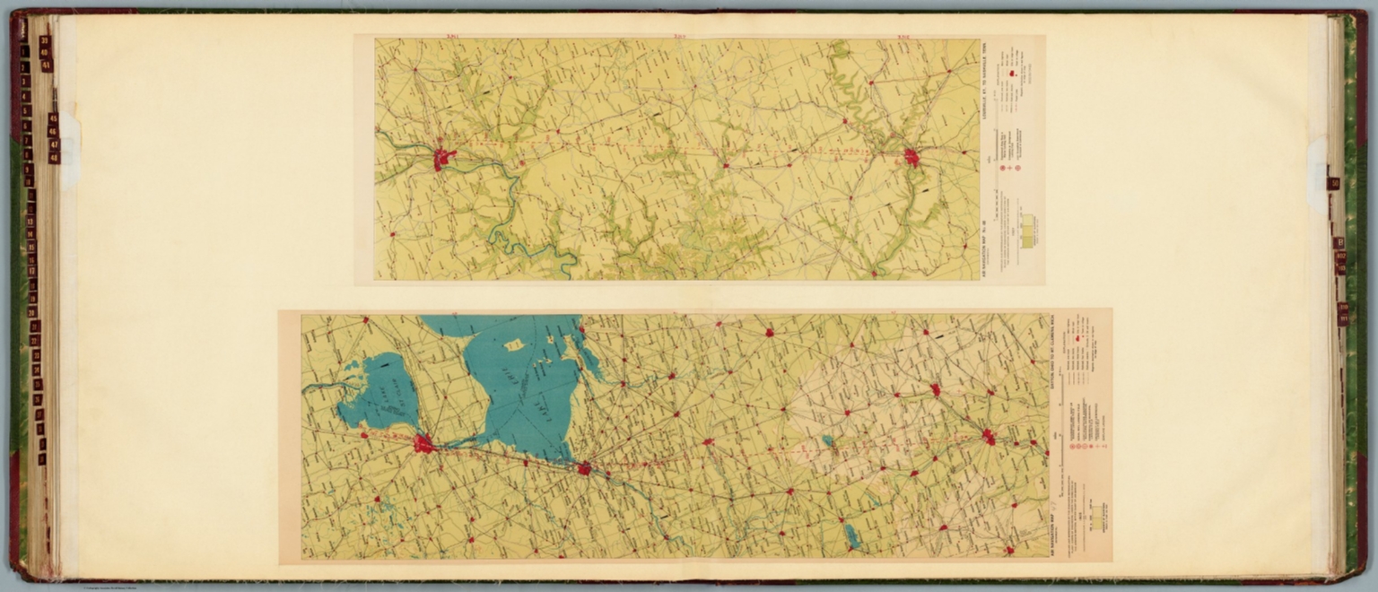
4. Air navigation map [47] (experimental) : Dayton, Ohio to Mt. Clemens, Mich. Compiled and reproduced by the Engineer Reproduction Plant, Corps of Engineers. Under the direction of the Airways Section, Office Chief of Air Service. 1925. Engineer Reproduction Plant, U.S. Army, Washington Barracks, D.C. 4915-47. 1926. -- Air navigation map 48 (experimental) : Louisville, Ky. to Nashville, Tenn. Compiled and reproduced by the Engineer Reproduction Plant, Corps of Engineers. Under the direction of the Airways Section, Office Chief of Air Corps. 1927. Engineer Reproduction Plant, U.S. Army, Washington Barracks, D.C. 6275-48.
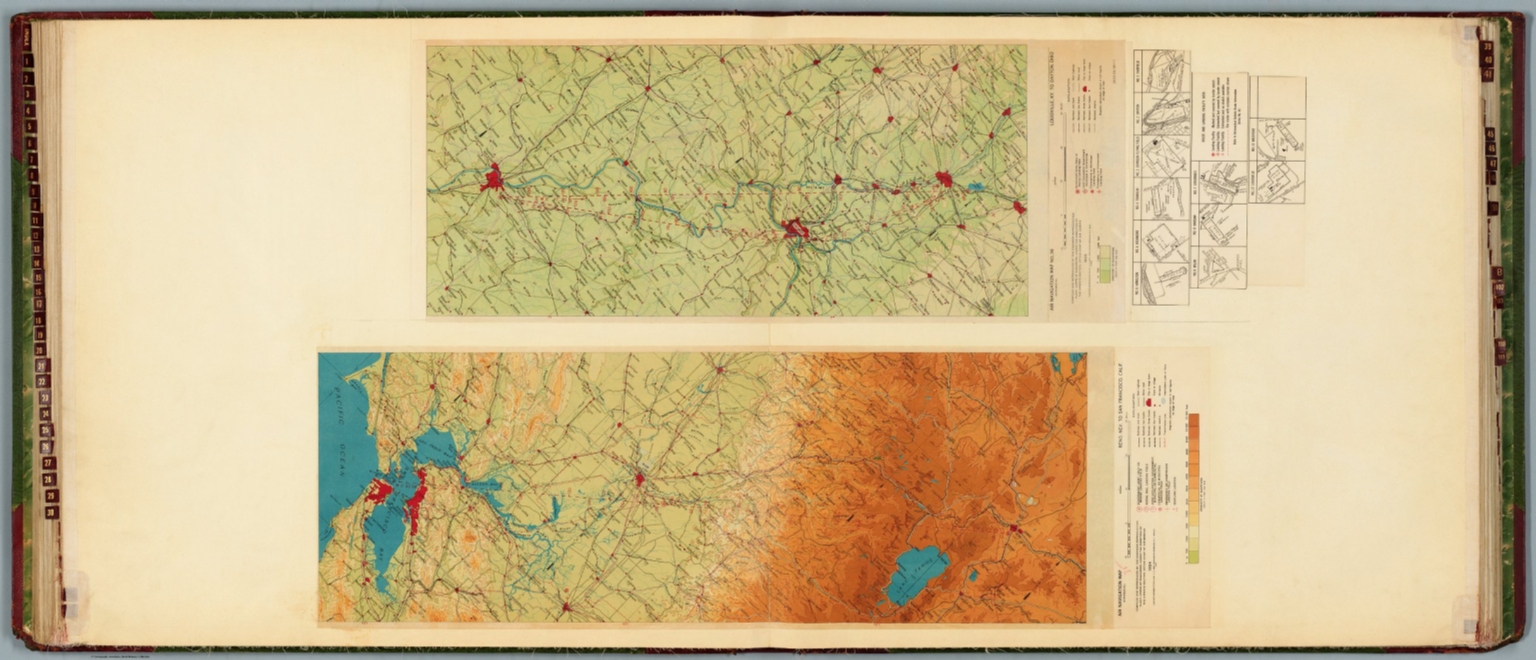
5. Air navigation map [35] (experimental) : Reno, Nev. to San Francisco, Calif. Compiled and reproduced by the Engineer Reproduction Plant, Corps of Engineers. Under the direction of the Airways Section, Office Chief of Air Service. 1924. Engineer Reproduction Plant, U.S. Army, Washington Barracks, D.C. 4915-35. 1926. -- Air navigation map no. 36 (experimental) : Louisville, Ky. to Dayton, Ohio. Compiled and reproduced by the Engineer Reproduction Plant, Corps of Engineers. Under the direction of the Airways Section, Office Chief of Air Corps. 1925. Engineer Reproduction Plant, U.S. Army, Washington Barracks, D.C. 4915. R-1928.
6. Air navigation map [33] (experimental) : Salt Lake City, Utah to Elko, Nev. Compiled and reproduced by the Engineer Reproduction Plant, Corps of Engineers. Under the direction of the Airways Section, Office Chief of Air Service. 1924. Engineer Reproduction Plant, U.S. Army, Washington Barracks, D.C. 1926. 4915-33. -- Air navigation map [34] (experimental) : Elko to Reno, Nev. Compiled and reproduced by the Engineer Reproduction Plant, Corps of Engineers. Under the direction of the Airways Section, Office Chief of Air Corps. 1924. Engineer Reproduction Plant, U.S. Army, Washington Barracks, D.C. 4915-34.

7. Air navigation map no. 27 (experimental) : Beaumont to San Antonio, Texas. Compiled and reproduced by the Engineer Reproduction Plant, Corps of Engineers. Under the direction of the Airways Section, Office Chief of Air Corps. 1923. Engineer Reproduction Plant, U.S. Army, Washington Barracks, D.C. 4915. 1923 - R1927. -- Air navigation map [28] (experimental) : San Antonio to Dryden, Texas. Compiled and reproduced by the Engineer Reproduction Plant, Corps of Engineers. Under the direction of the Airways Section, Office Chief of Air Service. 1924. Engineer Reproduction Plant, U.S. Army, Washington Barracks, D.C. 1924. 4915.

8. Air navigation map [31] (experimental) : Nogales and Tucson to Phoenix, Arizona. Compiled and reproduced by the Engineer Reproduction Plant, Corps of Engineers. Under the direction of the Airways Section, Office Chief of Air Service. 1924. -- Air navigation map no. 32 (experimental) : Phoenix, Arizona to San Diego, Calif.. Compiled and reproduced by the Engineer Reproduction Plant, Corps of Engineers. Under the direction of the Airways Section, Office Chief of Air Corps. 1924. Engineer Reproduction Plant, U.S. Army, Washington Barracks, D.C. 4915-30. 1924 - R1927.

9. Air navigation map [25] (experimental) : Muskogee, Oklahoma to Ft. Worth and Dallas, Texas. Compiled and reproduced by the Engineer Reproduction Plant, Corps of Engineers. Under the direction of the Airways Section, Office Chief of Air Service. 1924. Engineer Reproduction Plant, U.S. Army, Washington Barracks, D.C. 1926. 4915-25. -- Air navigation map [26] (experimental) : Dallas and Ft. Worth to San Antonio, Texas. Compiled and reproduced by the Engineer Reproduction Plant, Corps of Engineers. Under the direction of the Airways Section, Office Chief of Air Service. 1923. Engineer Reproduction Plant, U.S. Army, Washington Barracks, D.C. 4915-25. 1924.

10. Air navigation map no. 23 (experimental) : Saint Louis to Kansas City, Mo. Compiled and reproduced by the Engineer Reproduction Plant, Corps of Engineers. Under the direction of the Airways Section, Office Chief of Air Corps. 1923. Engineer Reproduction Plant, U.S. Army, Washington Barracks, D.C. 4915. 1926. R1927. -- Air navigation map [24] (experimental) : Kansas City, Mo. to Muskogee, Okla. Compiled and reproduced by the Engineer Reproduction Plant, Corps of Engineers. Under the direction of the Airways Section, Office Chief of Air Service. 1923. Engineer Reproduction Plant, U.S. Army, Washington Barracks, D.C. 1924. 4915-24.

11. Air navigation map [21] (experimental) : Cleveland, Ohio to Chicago, Ill. Compiled and reproduced by the Engineer Reproduction Plant, Corps of Engineers. Under the direction of the Airways Section, Office Chief of Air Service. 1923. Engineer Reproduction Plant, U.S. Army, Washington Barracks, D.C. 1926. 4915-21. -- Air navigation map [22] (experimental) : Chicago, Ill. to St. Louis, Mo. Compiled and reproduced by the Engineer Reproduction Plant, Corps of Engineers. Under the direction of the Airways Section, Office Chief of Air Service. 1923. Engineer Reproduction Plant, U.S. Army, Washington Barracks, D.C. 1926. 4915-22.

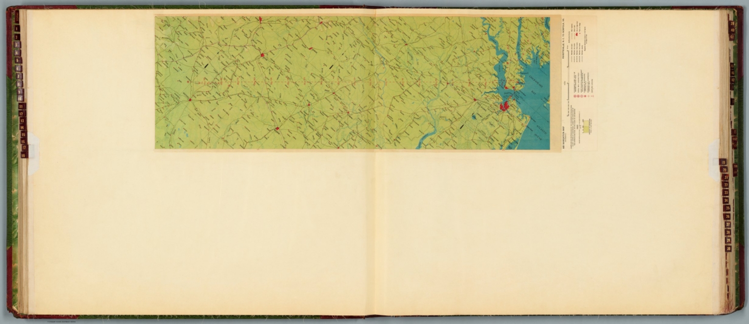
12. Air navigation map [18] (experimental) : Fayetteville, N.C. to Norfolk, Va. Compiled and reproduced by the Engineer Reproduction Plant, Corps of Engineers. Under the direction of the Airways Section, Office Chief of Air Service. 1925. Engineer Reproduction Plant, U.S. Army, Washington Barracks, D.C. 5737-18.
13. Air navigation map [13] (experimental) : Cheyenne to Rock Springs, Wyoming. Compiled and reproduced by the Engineer Reproduction Plant, Corps of Engineers. Under the direction of the Airways Section, Office Chief of Air Service. 1925. Engineer Reproduction Plant, U.S. Army, Washington Barracks, D.C. 4915-13. -- Air navigation map [14] (experimental) : Rock Springs, Wyoming to Salt Lake City, Utah. Compiled and reproduced by the Engineer Reproduction Plant, Corps of Engineers. Under the direction of the Airways Section, Office Chief of Air Service. 1925. Engineer Reproduction Plant, U.S. Army, Washington Barracks, D.C. 4915-14.

14. Air navigation map [11] (experimental) : Omaha to North Platte, Nebraska. Prepared under the direction of the Airways Section of the Chief of Air Service by the Topographic Branch, U.S. Geological Survey. 1925. Engineer Reproduction Plant, U.S. Army, Washington Barracks, D.C. 6068-11. 1925. -- Air navigation map [12] (experimental) : North Platte, Neb. to Cheyenne, Wyo. Compiled and reproduced by the Engineer Reproduction Plant, Corps of Engineers. Under the direction of the Airways Section, Office Chief of Air Service. 1925. Engineer Reproduction Plant, U.S. Army, Washington Barracks, D.C.

15. (Ordnance, ordnance stores, etc.). Julius Bien & Co., Lith., N.Y. (1891-1895)

16. Copy of a map. Sheet no. 1 military reconnaissance, Department of Virginia, Major-General Wool commanding. Drawn by Sergt. Ch. Worret and compiled under the direction of Col. T.J. Cram, Chief Top. Engrs., Dept. Va. (with) Campaign maps, Army of the Potomac. Map no. 1 Yorktown to Williamsburg. Prepared by command of Maj. Gen. George B. McClellan ..., Brig. Gen. A. A. Humphreys ... Map compilation under the direction of Brig. Gen. A.A. Humphreys, by Capt. H.L. Abbot, Top. Engrs., September 1862. Julius Bien & Co., Lith., N.Y. (1891-1895)

17. Map of the United States of America showing the boundaries of the Union and Confederate geographical divisions and departments, Dec. 31, 1862. Julius Bien & Co., Lith., N.Y. (1891-1895)

18. General topographical map. Sheet XX. Julius Bien & Co., Lith., N.Y. (1891-1895)

19. Map of the United States of America showing the boundaries of the Union and Confederate geographical divisions and departments, June 30, 1862. Julius Bien & Co., Lith., N.Y. (1891-1895)

20. Map of the United States of America showing the boundaries of the Union and Confederate geographical divisions and departments, April 9, 1865. Julius Bien & Co., Lith., N.Y. (1891-1895)

21. (Corps flags, badges, etc.). Julius Bien & Co., Lith., N.Y. (1891-1895)

22. (Care of and means of transportation of sick or wounded). Julius Bien & Co., Lith., N.Y. (1891-1895)

23. (Uniforms, officers and enlisted men). (with) Badges to distinguish rank, U.S. Army, epaulettes, shoulder straps, chevrons. (with) Buttons, U.S. Army. (with) Collar badges, C.S. Army. (with) Sleeve badges, C.S. Army. (with) Chevrons, C.S. Army. (with) Caps, C.S. Army. (with) Buttons, C.S. Army. Julius Bien & Co., Lith., N.Y. (1891-1895)

24. Part of map of portions of the military departments of Washington, Pennsylvania, Annapolis and Northeastern Virginia. Compiled in the Bureau of Topographical Engrs., War Department &c., July 1861 ... report of Maj. Gen. Geo. B. McClellan ... and Maj. A.J. Myer ... Battle-fields of South Mountain showing the positions of the forces of the United States and of the enemy during the battle fought by the Army of the Potomac under the command of Maj. Gen. Geo. B. McClellan, Sept. 14, 1862. Prepared in the Bureau of Topographical Engineers. (with) Map accompanying Lieutenant General Pemberton's report of operations near Vicksburg, Miss., December 21, 1862, January 2, 1863. Surveyed and drawn by H.A. Pattison, Civil Engr. Julius Bien & Co., Lith., N.Y. (1891-1895)

25. Map of Fort Anderson, N.C. Captured February 19th 1865 by the Army of the Ohio. Maj. Gen. J.M. Schofield, Comd'g. Official Wm. J. Twining, Capt. and Ch'f. Engr. (with) Map of Franklin, Tenn. Including field works and positions of troops 4th and 23rd Corps, during the engagement of November 30th 1864. Maj. Gen. Schofield, Comd'g. ... (with) Map of the battle-field of Droop Mountain drawn from a partial survey by Henry Topping. 6th Nov. 1863. (with) Battle-ground near White Sulphur Springs. August 26 and 27, 1863. Drawn by Lieut. J.R. Meigs, U.S. Engrs. (with Savannah and Wright rivers, S.C., Feb. 6, 1862). Accompanying report of Maj. O.T. Beard ... Julius Bien & Co., Lith., N.Y. (1891-1895)

26. Engineer Office, Military Division of the Gulf. Map no. 5. Upper Potomac from McCoy's Ferry to Conrad's Ferry and adjacent portions of Maryland and Virginia showing the operations of the Army of the Shenandoah. Commanded by Maj. Gen. P.H. Sheridan, U.S.A. Drawn and lithographed under the direction of Bvt. Maj. G.L. Gillespie ... October 1865. (with) Sheet no. 2. Map of the battle-field of Cedar Creek, Va. fought Oct. 19th, 1864 and cavalry fight of Tom's Brook fought Oct. 9th 1864. Union forces commanded by Maj. Gen. P.H. Sheridan, U.S.A. Confederate forces commanded by Lieut. Gen. J.A. Early, C.S.A. Drawn and lithographed under the direction of ... Col. G. Gillespie ... (with) Map showing the march routes of the Army of the Tennessee from Atlanta to Savannah during the campaign in Georgia, under the command of Maj. Gen. O.O. Howard. Compiled and drawn under the direction of Capt. C.B. Reese ... by L. Helmle ... (with) Plate showing positions of the 15th Army Corps, Maj. Gen. P.J. Osterhaus, commanding in front of Savannah, Ga., Dec. 1864. Drawn by C. v. Seutter. Julius Bien & Co., Lith., N.Y. (1891-1895)

27. General topographical map. Sheet IX. Julius Bien & Co., Lith., N.Y. (1891-1895)

28. General topographical map. Sheet IV. (with) Entrance to Cape Fear River, North Carolina. Julius Bien & Co., Lith., N.Y. (1891-1895)

29. General topographical map. Sheet VII. Julius Bien & Co., Lith., N.Y. (1891-1895)

30. Map of a part of Virginia exhibiting the routes of Genl. W.W. Averell, in his three expeditions of August, November & December, 1863. Drawn under the direction of Lieut. J.R. Meigs, Corps of Engineers, Chief Engr. Dept. W. Va. (with) Map of the New Creek Sta., B.& O.R.R. Drawn by John R. Meigs ... Aug. 1863. (with) Map of Tete de Pont and battle of Big Black Bridge, May 17th, 1863. Saml. H. Lockett ... (with) Map of the battle-field of Baker's Creek, May 16th 1863. Saml. H. Lockett. Wm. L. Sheppard, draughtsman. Field works at Franklin, Tenn. Occupied by the 23rd and 4th Corps during engagements of Nov. 30th 1864. Maj. Gen. J.M. Schofield, com'd'g. Official: Wm. J. Twining ... Julius Bien & Co., Lith., N.Y. (1891-1895)

31. Campaign maps, Army of the Potomac. Map no. 3. White House to Harrison's Landing. Prepared by command of Maj. Gen. George B. McClellan ... Brig. Gen. A.A. Humphreys, Chief of Top. Engrs., Army of the Potomac. (with) Official plan of the Siege of Yorktown, Va. conducted by the Army of the Potomac under the command of Maj. Gen. George B. McClellan, U.S.A., April 5th to May 3rd 1862. Prepared under the direction of Brig. Gen. J.G. Barnard ... by Lieut. Henry L. Abbot ... (with) Campaign maps, Army of the Potomac. Map no. 2. Williamsburg to White House ... (with) Sketch no. 1, Mulberry Island, Va. (with) Sketch no. 2. Principal work on Mulberry Island, Va. Julius Bien & Co., Lith., N.Y. (1891-1895)

32. Section of G. Woolworth Colton's new guide map of the United States and Canada with railroads, counties, etc. 1863. Used by General Grant in marking the proposed lines of operations of the armies of the United States, in 1864. Julius Bien & Co., Lith., N.Y. (1891-1895)

33. Sketch showing the positions of the Army on the battle-field of Chancellorsville, Va., May 1 to 5. E.F. Hoffmann, Lieut. 35th U.S. Inftry. ... Section of Map of Buckingham and Appomattox counties, Va. Surveyed under direction of A.H. Campbell ... D.V.N., by Charles E. Cassell, Lieut. Eng'rs. P.A.C.S. December 25th 1863. (with) Map of the battle-field of Wilson's Creek, Mo, Aug. 10, 1861. Wm. Hoelcke ... Hdqrs., Departmt. of the Mo., St. Louis, 1865. (with) Battle of Cedar Mountain, Va. Fought August 9th 1862. (with) Map of Hanover, Henrico and part of Chesterfield counties, Va. Section. Chief Engineer's Office, D.N.V., Col. J.F. Gilmer, Chief Engineer. Under the direction of A.H. Campbell ... 1864. Draughtsman, S.B. Linton. (with) Defenses of Macon, Ga., 1864. Julius Bien & Co., Lith., N.Y. (1891-1895)

34. Section of map of parts of Brunswick and New Hanover counties showing the approaches to Wilmington, N.C. Department of Cape Fear, Maj. Gen. W.H.C. Whiting, commanding. Made under the direction of W.H. James, Ch. Eng'r. by B.L. Blackford ... Fort Caswell and adjoining works at western bar Cape Fear, N.C. Evacuated Jan. 16th 1865. Taken possession of ... Jan. 17th 1865. Line of rebel works, Smith's Island, N.C. Evacuated Jan. 16th 1865. Taken possession of ... Jan. 17th 1865. (both) North Atlantic Squadron, Read-Admiral D.D. Porter, commanding. Defenses of Augusta, Ga. From original in possession of Gen. Braxton Bragg, C.S. Army. (with) Fort Johnston, Smithville, N.C. ... (with) Augusta, Ga., 1864. (with) Plan of the fortifications at Columbus, Ga., 1864. (with) Map of the battle-field of Champion's Hill, Miss., May 16, 1863. Engineer's Office, Dept. of the Tenn., Capt. C.B. Comstock, Chief Engr. From surveys by F. Tunica ... and sketches by Brig. Gen. A.P. Hovey and Capt. A. Hickenlooper. Drawn by H.A. Ulffers ... Julius Bien & Co., Lith., N.Y. (1891-1895)

35. Topographical map of California, Nevada, Oregon and part of Idaho. Prepared from field surveys and other reliable data. Under the direction of Bvt. Lt. Col. R.S. Williamson, Corps of Engineers, U.S.A. Drawn by W.B. Hyde. 1867.. Julius Bien & Co., Lith., N.Y. (1891-1895)

36. Position of iron clads, January 15th, 1865. Engine 'Hero' destroyed partially by rebels when avacuating (sic) Atlanta, Ga. (with) Rebel lines, Atlanta, Ga. looking across Augusta R.R. to the southward. (with) Rebel line on Augusta R.R. ... looking south. (with) Rebel lines on west side of Atlanta, Ga. looking southward. (with) Rebel lines, Atlanta, Ga. (with) U.S. Rolling Mill at Chattanooga, Tenn. (with) Ruins of rolling mill and cars destroyed by rebels on evacuation of Atlanta, Ga. (with) Round-house, Chattanooga R.R. at Atlanta, Ga. (with) Potter House, Atlanta, Ga. showing effects of bombardment. Julius Bien & Co., Lith., N.Y. (1891-1895)

37. Map of Charleston and its defenses, compiled from surveys of portions of St. Andrew's and Christ Ch. parishes by Lieut. John Johnson, C.S. Engrs ... Under the direction of Maj. Wm. H. Echols, C.S. Engr's Corps ... by Wm. A Walker, draughtsman ... Drawn by John R. Key ... Charleston, S.C., Nov. 28th 1863. (with) Map of New Berne, N.C. and defenses. Copied from Cleveland Rockwell's U.S. Coast Survey chart of New Berne and approaches, with additions under the direction of Lieut. Wm. R. King, U.S. Eng'rs. by Solon M. Allis, 27th Mass., July 1864. (with) Diagrams illustrating the 1st and 7th positions occupied by the 4th Division, 17th Army Corps, during the battle of Atlanta, Ga., July 22, 1864. Julius Bien & Co., Lith., N.Y. (1891-1895)

38. Panoramic view of Knoxville, Tenn. from cupola of University of East Tennessee, March 18th 1864. Knoxville, Tenn. from Fort Stanley, March 19, 1864. Panoramic view of Knoxville, Tenn. from cupola of University of East Tennessee. March 18th 1864. Chattanooga, Tennessee, 1864. Knoxville, Tenn. from Mabry's Hill. Chattanooga, Tennessee 1864. Julius Bien & Co., Lith., N.Y. (1891-1895)

39. Map illustrating the battle of Bentonville, N.C., fought March 19th 1865 between the United States forces commanded by Maj. Gen. H.W. Slocum and the rebel forces commanded by Gen. Jos. E. Johnston and the operations of March 20th and 21st under direction of Maj. Gen. W.T. Sherman ... Compiled under direction of O.M. Poe, Bvt. Col. U.S.A., by Major E.F. Hoffmann. (with) Map illustrating the battle of Averasborough, N.C. fought March 16th 1865 ... (with) Savannah, Ga., submitted with my report ... March 30th 1862. Q.A. Gillmore ... (with) Map of Bird's Point, Mo., from surveys in the summer of 1861. J.D. Webster, Mar. Actg. Engr. Julius Bien & Co., Lith., N.Y. (1891-1895)

40. Federal Fort No. 11, Atlanta, Ga. ... looking toward No. 12. Federal Fort No. 12 ... looking towards City Hall ... Federal Fort No. 12 ... looking towards No. 11. Federal Fort No. 13 ... Federal Fort No. 19 ... looking north. Federal Fort No. 19 ... looking south. Rebel fort, south of Chattanooga R.R., Atlanta, Ga. Rebel fort, Atlanta, Ga. between Peach Tree Street and Chattanooga Railroad. Rebel fort on Chattanooga R.R., Atlanta, Ga., Potter's House. Rebel fort on Peach Tree Street, Atlanta, Ca. Casemated battery on salient of rebel line, near White Hall, looking north towards Chattanooga R.R., 2 miles S.W. of Atlanta, Ga. Rebel battery, Peach Tree Street, Atlanta, Ga. Julius Bien & Co., Lith., N.Y. (1891-1895)

41. Capitol, Richmond, Va. Front view taken May 1865. Libby Prison, north side. Taken May 1865. Libby Prison, south side, taken May 1865. (with) Post Hospital, City Point, Va., 1865. Rebel Fort, now Federal No. 7 of new lines, Atlanta Ga. (with) Federal Fort No. 7, Atlanta, Ga. New line of defenses looking towards No. 8. Federal Fort No. 8, Atlanta, Ga. New line of defenses looking towards No. 7. Federal Fort No. 9, Atlanta, Ga, new line of defenses ... (with) Federal Fort No. 10, Atlanta, Ga. New line of defenses looking toward No. 9. (with) Federal Fort No. 10, Atlanta, Ga. New line of defenses, looking east ... (with) Federal Fort No. 11, Atlanta, Ga. New line of defenses, looking towards No. 10. Julius Bien & Co., Lith., N.Y. (1891-1895)

42. Rebel lines, Atlanta, Ga. south of Chattanooga R.R. with Federal Fort No. 7. Rebel lines near Chattanooga Railroad ... showing battery silenced by our fire. Rebel line near Chattanooga Railroad ... looking across R.R. towards the south. Rebel lines near Chattanooga Railroad ... looking across Rail Road to the southwest ... Rebel lines near Chattanooga Railroad ... showing nature of obstructions. Rebel lines from Chattanooga Railroad ... Rebel lines, north side of Atlanta, Ga. Rebel lines, north side of Atlanta, Ga. between Peach Tree Street and Chattanooga Rail Road. Rebel lines east of Atlanta, Ga. looking toward Decatur. Rebel lines south-east of Atlanta, Ga., looking towards Augusta R.R. Rebel lines south-east of Atlanta, Ga. looking towards McPherson's battle-ground of July 22d. Rebel lines south-east of Atlanta, Ga. Julius Bien & Co., Lith., N.Y. (1891-1895)

43. Nashville, Tenn., from the south-east, showing the State Capitol. Accompanying letter of Col. W.E. Merrill ... (with) Fort on St. Cloud Hill, Nashville, Tenn. in course of construction, Oct. 15th '62. (with) Point of Lookout Mountain, Tenn. taken during high water, looking down the river. (with) Rossville Gap., Ga. (with) Buzzard Roost Gap and Rocky Face Ridge, Ga. (with) 100 pdr. gun battery, intrenchments at Dutch Gap, Va. (with) Canvass pontoon bridge, Appomattox River, Broadway, Va. (with) Battery Spofford, Va. (with) Signal station, Va. at Fort Wisconsin, left of line. Julius Bien & Co., Lith., N.Y. (1891-1895)

44. Battery Sawyer, Va. Battery Pruyn, Va. Redoubt Carpenter, Va. Redoubt Anderson, Va., No. 3. Redoubt McConihe, Va. Redoubt Dutton, Va. Redoubt Weed, Va. Redoubt Drake, Va. Castle Thunder, Richmond, Va. May, 1865. Dutch Gap Canal, as finished April, 1865. Pontoon Bridge on the James River above Jones' Landing, from the north side, 68 boats. Julius Bien & Co., Lith., N.Y. (1891-1895)

45. View of terre-plein of the gorge of Fort Sumter showing the guns on barbette, April 15th, 1861. Parade of Fort Moultrie showing south-western portion of soldiers barracks &c. April 16th, 1861 ... North-western angle of Fort Moultrie, interior of ramparts, back of western barracks, western side of Citadel, brick traverse for protection of magazine, sandbags covering magazine ... View of terre-pleine and parapet of eastern flank of Fort Sumter, also showing traverse constructed to counteract enfilading fire ... Barracks on north face of parade, Fort Moultrie ... South-western angle and face of Fort Moultrie ... Officers quarters, eastern portion of parade, Fort Moultrie ... Western barracks, Fort Moultrie seen from parapets showing the back of the buildings ... Channel face and south-western angle of the ramparts of Fort Moultrie ... (all) Charleston Harbor, S.C.. Accompanying report of Brig. Gen. G.T. Beauregard, C.S. Army. Julius Bien & Co., Lith., N.Y. (1891-1895)

46. Chattanooga, Tenn. from Cameron Hill, taken April 1864. Made under the direction of Capt. W.E. Merrill, Chief Engr., D.C. (with) U.S. military bridge over the Tennessee at Chattanooga, taken March 1864 ... (with) Part of Missionary Ridge, Tenn. (with) Govt. wagon yard at Chattanooga, Tenn. showing Cameron Hill and Fort Carpenter. (with) Blockhouse for defense of R.R. yard at Chattanooga, Tenn. (with) The Suck--Tenn. River below Chattanooga, looking up the river. (with) The Suck--Tenn. River below Chattanooga, looking down the river. Julius Bien & Co., Lith., N.Y. (1891-1895)

47. Engineer Bureau, War Department. Section of map of the states of Kansas and Texas and Indian Territory, with parts of the territories of Colorado and New Mexico. From the most recent official surveys and explorations and other authentic information. 1867. Julius Bien & Co., Lith., N.Y. (1891-1895)

48. Fort Donelson, Tenn. Copied from the original plan prepared under the direction of Col. Wm. E. Merrill by Maj. James R. Willett ... From a survey by John H. Willett, Jan. 1865 ... Track of interior crest Fort Pickering, Memphis, Tenn. showing the interior works ... copied from a tracing ... by Maj. Gen. Gillmore. W. Claypoole, del. Z.B. Tower, Brig. Gen. and Insp. Gen. Fortifications, Mil. Div. Miss. Memphis and its environs ... 1865. (with) Defenses of Nashville, Tenn. Fort at Hyde's Ferry ... (with) ... Plan and section of redoubt on north side of Cumberland River 3/4 mile from the railroad bridge ... (with) ... Fort Harker. Planned and built by Brig. Gen. St. Clair Morton ... Julius Bien & Co., Lith., N.Y. (1891-1895)

49. Exterior view of the gorge of Fort Sumter on the 14th April 1861, after its evacuation by Maj. Robert Anderson ... Channel face of Fort Moultrie with bomb-proof shelter and flag staff, April 16th 1861 ... Sullivan's Island, Battery Beauregard 1864 ... Fort Sumter, December 9th 1863, view of south-east angle. Fort Sumter, December 9th 1863, interior view of three-gun battery. Fort Sumter December 9th 1863, view from south-west angle. Fort Sumter, December 9th 1863, view of entrance to three-gun battery. Julius Bien & Co., Lith., N.Y. (1891-1895)

50. Territory and Military Department of Utah, compiled in the Bureau of Topograph(ica)l. Engrs. of the War Depart(men)t. chiefly for military purposes. Under the authority of Hon. J.B. Floyd, Sec. of War. 1860. (with) March routes of Army of the Tennessee from Savannah, Ga. to Columbia, S.C., 1865. Accompanying the report of Maj. Gen. O.O. Howard, U.S. Army. Julius Bien & Co., Lith., N.Y. (1891-1895)

Catalog
Books, media, physical & digital resources
Discovery Service for Jio Institute Digital Library
For full access to our library's resources, please sign in.