Back to Search
Start Over
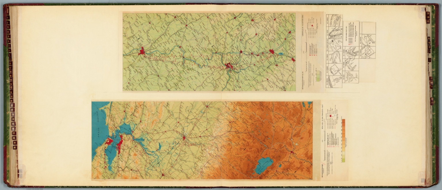
Air navigation map [35] (experimental) : Reno, Nev. to San Francisco, Calif. Compiled and reproduced by the Engineer Reproduction Plant, Corps of Engineers. Under the direction of the Airways Section, Office Chief of Air Service. 1924. Engineer Reproduction Plant, U.S. Army, Washington Barracks, D.C. 4915-35. 1926. -- Air navigation map no. 36 (experimental) : Louisville, Ky. to Dayton, Ohio. Compiled and reproduced by the Engineer Reproduction Plant, Corps of Engineers. Under the direction of the Airways Section, Office Chief of Air Corps. 1925. Engineer Reproduction Plant, U.S. Army, Washington Barracks, D.C. 4915. R-1928.
- Publication Year :
- 1928
- Publisher :
- Ford Motor Company, Washington, D.C., 1928.
-
Abstract
- Two aeronautical charts representing the areas from Reno, Nevada, to San Francisco, California, and from Louisville, Kentucky, to Dayton, Ohio. Features military, municipal, commercial, emergency, and seaplane landing fields. Also shows political boundaries, roads, railways, cities, towns, topography, bodies of water, drainage, and coastlines. Relief shown with contour lines and color coding. Maps include latitudinal and longitudinal lines, legend, scale statements, and bar scales given in miles, as well as compass roses oriented toward top of sheet (with slight variation between the two maps). aeronautical chart no. 36 includes eleven inset maps showing route and landing facilities. Color lithographs. Together, maps are 56 x 85 cm, on double sheet, 60 x 135 cm. Map number 35 provided with a handwritten annotation.<br />Airway Maps - Ford Motor Company. Folio. Cover is green printed fabric with red leather corners, gilt title and decoration. With gilt spine title and decorated leather spine. French fold binding. Charts were commissioned by the Ford Motor Company, and compiled by the United States Department of Commerce, Army Air Corps, and Hydrographic Office in Washington, D.C., 1923-1930. In total, the atlas includes 74 aeronautical charts on 39 double sheets. Charts feature military, municipal, commercial, emergency, and seaplane landing fields, as well as beacons. Charts also shows political boundaries, roads, railways, cities, towns, topography, bodies of water, drainage, shorelines and coastlines. Charts are color lithographs pasted onto folio sheets. This is a unique, comprehensive collection of the earliest official air navigation charts produced in the United States. This custom composite atlas was compiled for the Ford Motor Company amidst the production of their iconic Trimotor aircraft, which was produced from 1926 to 1933. This atlas incorporates the three earliest series of official American air navigation charts, spanning from 1923 to 1930, presenting an unparalleled picture of the birth of nationwide civil aviation in the United States. The atlas includes charts from the Army Air Corps, the Department of Commerce, and the U.S. Hydrographic Office. Each chart showcases the evolving standards and methodologies of air navigation, reflecting the advancements in aviation technology and the political considerations that shaped American aviation policy in the 1920s. The birth of American commercial aviation traces its genesis to the early 20th century, following significant advancements in aviation technology and the success of military flight operations during World War I. In 1914, the world's first scheduled passenger airline service, operated by the St. Petersburg-Tampa Airboat Line, took flight in Florida, using a Benoist XIV airboat. This pioneering venture catalyzed the establishment of more organized and expansive air services. The Air Mail Act of 1925, commonly known as the Kelly Act, further accelerated the growth of the commercial aviation sector in the United States by authorizing the United States Post Office to contract with private airlines to transport mail. Subsequent legislation, including the Air Commerce Act of 1926, provided federal oversight and regulations for this nascent industry. By the 1930s, with infrastructural developments like airports and improvements in aircraft technology, commercial airlines had become integral components of the American transportation landscape, revolutionizing long-distance travel and setting the stage for the global aviation industry of the 20th century. On February 22, 1921, a pioneering experiment was conducted to determine the feasibility of cross-country flights without halting at nightfall. Two planes, each taking off from opposite coasts, attempted to traverse the route between New York and San Francisco. To aid night navigation, bonfires were strategically placed along the path. Of the participants, one mail plane, piloted by the aviator Jack Knight and equipped solely with a railroad map and a compass, successfully completed the journey. The first daytime, coast-to-coast airmail flight had only been completed the year before. Around the same time, in 1921, the United States Army Air Corps began an extensive evaluation of aeronautical charts, aiming to establish a standardized map for aerial navigation. As a result of this study, in 1923, the Air Corps began to issue a series of air navigation maps covering the country's main air routes. Before 1926, these maps were produced in collaboration between the U.S. Geological Survey and the U.S. Army Engineer Reproduction Plant. However, with the passage of the Air Commerce Act in 1926, the responsibility for creating these maps transitioned to the U.S. Coast and Geodetic Survey under the authority of the Department of Commerce. From this point forward, the objective was to integrate the burgeoning commercial airways system with the existing military network. The U.S. Navy and Hydrographic Office also determined to create a set of air navigation maps focused on the coasts of the United States. Sets of these maps from the 1920s are exceedingly rare, largely because pilots of that era would only carry individual maps pertinent to their specific routes. Given that a pilot would typically be responsible for only a handful of routes at any given time, there was rarely a need to possess a comprehensive collection. Furthermore, the number of long-haul pilots in the United States during this period was quite limited, which further decreased the circulation of these maps. Compounding their rarity, as aviation technology and knowledge advanced, these maps were swiftly updated and replaced, leading to the disposal of earlier versions. In some cases, it is clear that newer versions of individual charts have been pasted over earlier editions. This atlas contains a comprehensive collection of charts from the three previously mentioned series, extending up to approximately March 1930. This means that many of the maps in the Department of Commerce series had not yet been completed and printed, and that only two charts from the Hydrographic Office had been completed when the atlas was compiled. Charts not included are numbers 17, 106-109, 113, 116-118, 120-126, 135-137 (titles listed below): Air Navigation Map No. 17 [left blank according to Airway Bulletin 11a] Airway Map No. 106 Pilottown - New Orleans Airway Map No. 107 New Orleans - Jackson Airway Map No. 108 Jackson - Memphis Airway Map No. 109 Memphis - St. Louis Airway Map No. 113 Twin Cities - Fargo Airway Map No. 116 Cincinnati - Dayton - Cleveland Airway Map No. 117 Cleveland - Buffalo Airway Map No. 118 Detroit - Buffalo Airway Map No. 120 Albany - Boston Airway Map No. 121 New York - Albany Airway Map No. 122 Albany - Montreal Airway Map No. 123 Miami - West Palm Beach - Titusville Airway Map No. 124 Tampa - Titusville Airway Map No. 125 Titusville - Jacksonville Airway Map No. 126 Jacksonville - Atlanta Airway Map No. 135 Salt Lake City - Boise Airway Map No. 136 Boise - Pasco Airway Map No. 137 Pasco - Seattle Historical notes supplied by Barry Lawrence Ruderman, Antique Maps Inc.
- Subjects :
- Aeronautical charts
Airlines
Subjects
Details
- Database :
- LUNA Commons
- Publication Type :
- Map
- Accession number :
- edsluc.RUMSEY.8.1.358284.90125235
- Document Type :
- National Atlas<br />Atlas Map