68 results
Search Results
2. Educational and Occupational Attainment of Migrants and Nonmigrants from a Colombian Highland Community. Research Paper 63.
3. Student Loans in Developing Countries: An Evaluation of the Colombian Performance. Bank Staff Working Paper No. 182.
4. Income Distribution and Colombian Rural Education. Program of Development Studies Paper No. 54.
5. Public Expenditures on Education and Income Distribution in Colombia. World Bank Staff Occasional Papers Number Eighteen.
6. [Innovative Programs in Adult Education: Foreign.]
7. Urbanization in Colombia. An International Urbanization Survey Report to the Ford Foundation.
8. The Piece of Paper.
9. Bull-Ring Massacre.
10. The Wheel of Hate.
11. Over the Fence Is Out.
12. Black Art.
13. Censorship as Usual.
14. Starving Soldiers.
15. Rebuke from the Church.
16. The Urge to Kill.
17. Group Life.
18. Good Deal.
19. Aftermath.
20. LATIN AMERICA: A DIVIDED CHURCH.
21. Billy in Catholic Country: He Collides with Clergy.
22. Ancienne Colombie. Nle. Grenade, Venezuela, Equateur. Guyanes. Atlas spheroidal & universel de geographie dresse par F.A. Garnier, geographe. Paris, Ve. Jules Renouard, Editeur, Rue de Tournon, no. 6. 1860. Paris, Sarazin Impr., rue Git-le-Coeur, 8.

23. (Covers to) H. Kiepert's Karte des nordlichen tropischen America. A new map of Tropical-America north of the equator comprising the West-Indies, Central-America, Mexico, New Granada and Venezuela. Composed with the help of all cartographic and litterary (sic) materials hitherto published and dedicated by permission to His Excellency Baron Alexander von Humboldt By H. Kiepert, Ph. Dr. M.R., Acad. Berlin, F. Geogr. Soc. of. Berlin, Paris and Vienna. 1858. Published by Dietrich Reimer, Berlin. Lithogr. and printed by C. Monecke, Berlin. Lith. Inst. von C. Monecke in Berlin. (with) Central part of the Mexican Republic ... based on the surveys published by A.v. Humboldt, v. Gerolt, Heller, Smith and the Sociedad Mejicana de Geografia t Estadistica.

24. H. Kiepert's Karte des nordlichen tropischen America. A new map of Tropical-America north of the equator comprising the West-Indies, Central-America, Mexico, New Granada and Venezuela. Composed with the help of all cartographic and litterary (sic) materials hitherto published and dedicated by permission to His Excellency Baron Alexander von Humboldt By H. Kiepert, Ph. Dr. M.R., Acad. Berlin, F. Geogr. Soc. of. Berlin, Paris and Vienna. 1858. Published by Dietrich Reimer, Berlin. Lithogr. and printed by C. Monecke, Berlin. Lith. Inst. von C. Monecke in Berlin. (with) Central part of the Mexican Republic ... based on the surveys published by A.v. Humboldt, v. Gerolt, Heller, Smith and the Sociedad Mejicana de Geografia t Estadistica.

25. Padlocked Flagship.
26. New President.
27. Collared by the Cops.
28. The Cocacolos.
29. General Satisfaction.
30. Backlands Bolshevism.
31. Conversation in a West Indian Taxi: An Ethnolinguistic Analysis
32. The Reproductive Performance of British Breeds of Sheep in an Equatorial Environment. II. Lowland Breeds
33. Observations on Mosquito Density in an Endemic Malarious Area in Eastern Colombia
34. [Psychodynamics of ideological democracy]
35. [University crisis and student psychiatric service]
36. A simplified system for surgical operations: The economics of treating hernia
37. Carte Panoramique de L'isthme de Darien Central [Etats-Unis de Colombie] Publiee Par La Societe Internationale du Canal Colombien (41, Rue de Douai) D'apres la Carte de Mr. L. de Puydt, Chef des expeditions scientifiques en Colombie pendant les annees 1861-1865 & 1866.

38. America Centr., India Occid., Columbia, Venezuela e Guaiana : Carta fisico-politica. Istituto Geografico de Agostini - Novara, di Cesare Rossi e dott. A. Marco Boroli.

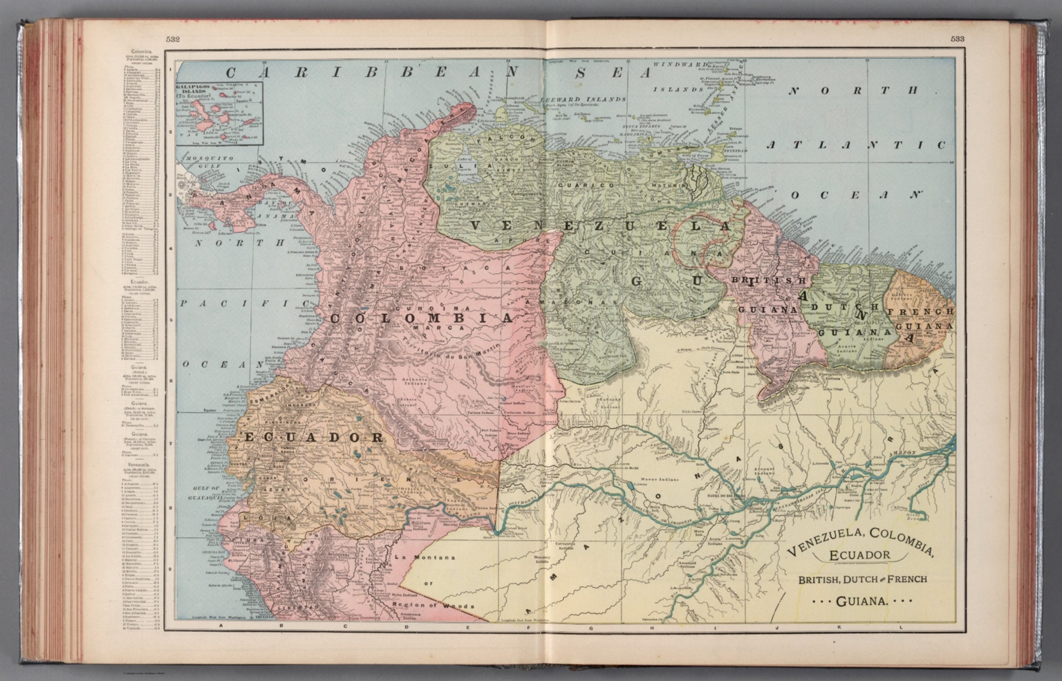
39. Venezuela, Colombia, Ecuador, British, Dutch and French Guiana.
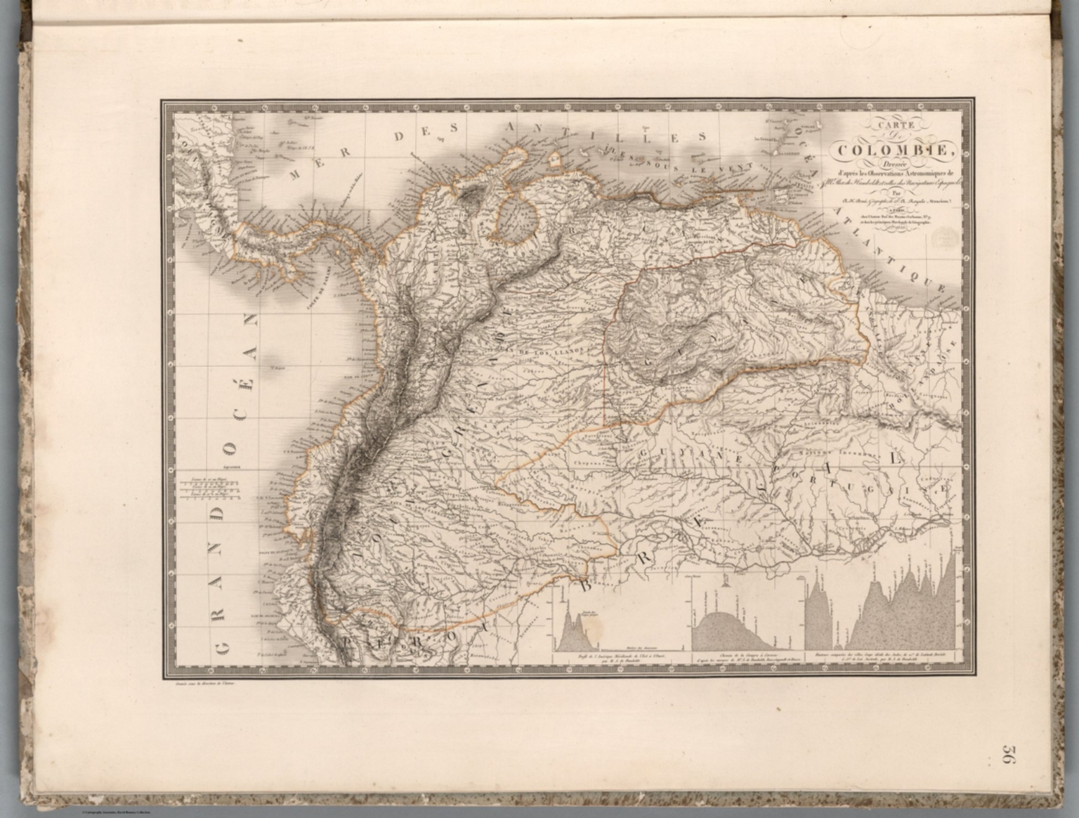
40. Carte de Colombie : dressee d'apres les Observations Astronomiques de Mr. Alex. de Humboldt et celles des Navigateurs Espagnols, par A. Brue ... Paris. 1823. Chez l'Auteur. (to accompany) Atlas physique et politique des cinq parties du monde, par H. Brue.
41. Venezuela, New Grenada & Equador. 43. Entered ... 1859, by Charles Desilver ... Pennsylvania. (inset) Map of the Communications by Railroad across the Isthmus of Darien from Aspinwall to Panama. (to accompany) A New Universal Atlas Containing Maps of the various Empires, Kingdoms, States and Republics Of The World.

42. Carte de la Republique de Colombie. Par L. Vivien, Geographe. Grave par Giraldon Bovinet. 1826. Paris. Chez Menard et Desenne, Rue Git le Coeur, No. 8.

43. Colombia. Drawn and Published by F. Lucas Jr., Baltimore. Young & Delleker, Sc. Philada. (1822)

44. Republica de Colombia, Mapa Fisico Politica.

45. Carthagena. Engraved for Luffman's Select plans. Engrav'd & Publish'd Feby. 1.1802, by J. Luffman. London.

46. XXII. Carte generale de Colombia.

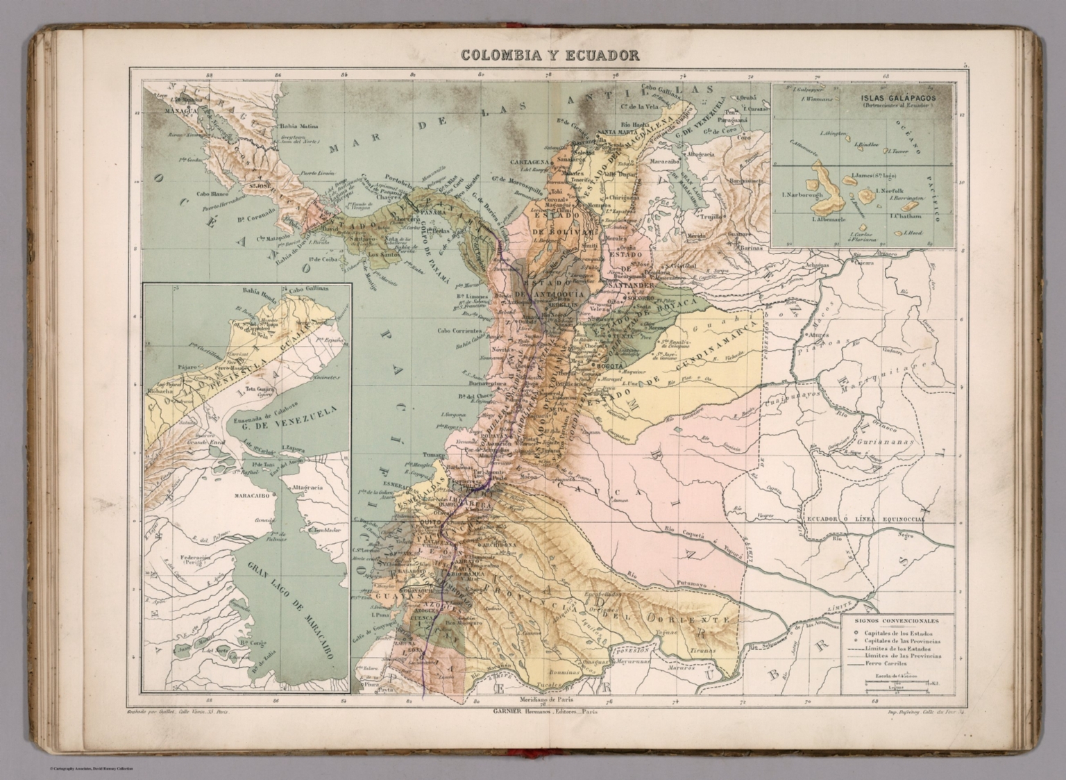
47. Colombia y Ecuador. Grabado por Guillot. Garnier Hermanos, Editores, Paris. Imp. Dufrenoy. (To accompany) Atlas geografico de America ... Por N. Estevanez. Paris : Libreria de Garnier Hermanos. 1885. (insets) Peninsula de Guajira. (with) Islas Galapagos.
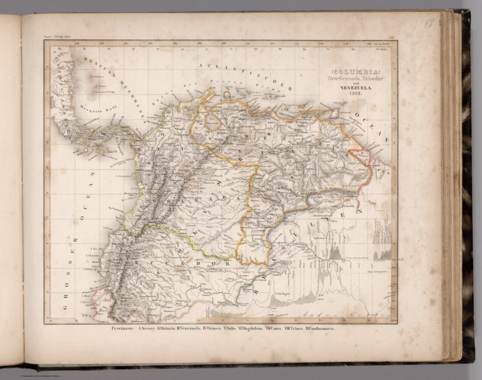
48. (Columbia) Neu-Granada, Ecuador und Venezuela. 1849. (in upper margin) Meyer's Zeitung Atlas. No.17. (to accompany) Neuester Zeitungs-Atlas fur Alte und Neue Erdkunde. Herausgegeben von J. Meyer. (inset Profiles) Andes Kette. (with) Fall des Amazonen Stroms.
49. Carte generale de Colombie, de la Guyane Francaise, Hollandaise et Anglaise. Redigee par A.H. Brue, Geographe du Rio ... Paris, 1826. Chez l'Auteur, rue des Macons-Sorbonne, no. 9, et chez les principaux m(archan)ds de cartes geographiques. (to accompany) Atlas de choix ou Recueil de cartes de geographie ancienne et moderne.

50. Ecuador, Colombia, Venezuela, Guiana. (inset) Bogota. (inset) Caracas. Pergamon World Atlas. Pergamon Press, Ltd. & P.W.N. Poland 1967. Sluzba Topograficzna W.P.

Discovery Service for Jio Institute Digital Library
For full access to our library's resources, please sign in.