10 results
Number of results to display per page
Search Results

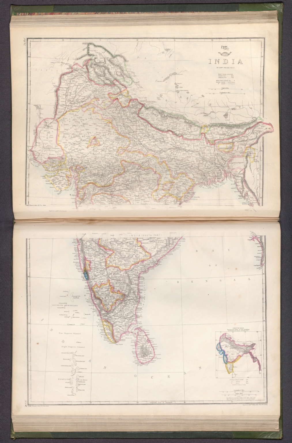
2. (Composite Map to) India : (South part) -- India : [North part] / by Edwd. Weller F. R. G. S. ; engraved by Edwd. Weller, Duke Street Bloomsbury.

- Author
-
Weekly Dispatch and Weller, Edward, 1819-1884
- Subjects
Military - Abstract
Composite map of India (south and north parts). Shows political boundaries (delineating British territories and independent states), cities, military stations, railways, topography, bodies of water, drainage, coastlines and islands. Relief shown with hachures. Includes latitudinal and longitudinal lines, as well as a legend and bar scales given in English and geographical miles. With inset map: Sketch map, showing the extent of each Presidency and the Protected States attached to it. Hand-colored lithograph. Map is 60 x 42 cm, on two sheets, together 69 x 48 cm. Sheets presented in sequence. Appears in Vol. II : Foreign., The dispatch atlas, in two volumes: Vol. I : British and .Vol. II : Foreign. Published by the Weekly Dispatch, London, 1863. Includes a preface, directions for binding and a table of contents for both volumes, which lists the maps in order of appearance, with plate numbers handwritten beside map titles. Preface begins: The subscribers to the Weekly Dispatch have in this collection the most full and accurate survey of the world's surface that has yet been presented to the public in any single series. Both volumes bound in board covered in dark green linen, with spine and corners in calf. Gilded spine titles, as well as ornamentation on spines and front and back covers. With marbled end papers and gilded page edges. Collation: Volume I: [6] pages, 129 leaves of plates (some double); Volume II: 147 leaves of plates (some double). The work’s total 276 plates contain 300 maps. Each plate number handwritten in ink above map. First volume focuses on the British Isles, especially England. Second volume covers the larger globe, featuring Europe, the Middle East, Asia, Africa, North America, Central America, South America, Australia, New Zealand, the Pacific Ocean and the Arctic. Maps show political boundaries, cities, fortresses, railways, roads, bridges, canals, ocean routes, topography, glaciers, bodies of water, drainage, coastlines, shoals, islands and water depths. Maps of the Americas include territories of indigenous peoples. Maps of the United States south delineate between Federal, Border and Confederate States. Some maps feature English translations of terms from other languages that describe geographic features, including the “Explanation of Arabic words" - such as nahr for river - in the Map of Syria. Maps created by Edward Weller, J. W. Lowry, B. R. Davies, John Dower and T. Ettling; printed by Edward Weller and Day & Son, Lithographers to The Queen.
- Published
- 1863
3. A map of the Peninsula of India from the 19th degree north latitude to Cape Comorin. MDCCXCII. London, printed for W. Faden, Geographer to the King and to the Prince of Wales, Charing Cross, May 1st, 1793. R. Baker, sculp. Islington. (2)

- Author
-
Faden, William, 1749-1836 and Baker, R.
- Subjects
Political - Abstract
Map of India, showing southern half of Peninsula, as of 1792. Shows political boundaries, cities, roads, topography, bodies of water, drainage, coastlines, islands and sand banks. Relief shown with hachures. Includes latitudinal and longitudinal lines, as well as a legend. Decorative cartouche. Explanatory note and descriptive text throughout, including notes on exploration. Hand-colored engraving. Map is 49 x 80 cm, on fold-out sheet 55 x 86 cm. With stamp: Liverpool Library. Second of two sheets; first sheet shows northern half of the Indian Peninsula., Published in London, 1794. Composite world atlas by William Faden (1749-1836). Bound in 19th century half red calf over purple pebble-grain cloth, with gilt spine title. Pink end papers. Bookplate: Liverpool Library, Lyceum, Bold Street. Stamp for the “Liverpool Library” on many of the maps within. Elephant folio. Collation: 2° : [1], 48 leaves of plates. With a contemporary manuscript index listing forty-eight subjects in order of appearance, including the wall-maps of the Mediterranean, Asia, India, Africa and the Americas, each joined in two sections and listed as two subjects. Geographic coverage spans the globe, including maps of the Western, Eastern, Northern and Southern Hemispheres, as well as Europe, the United States and the West Indies. Maps show political boundaries, cities, roads, canals, topography, deserts, bodies of water, drainage, coastlines, islands, water depths and anchorage. Maps feature routes of European exploration, such as the voyages of Captain Cook. Maps include decorative cartouches and descriptive text, including notes on voyages. Engravings with original hand-coloring. See our 2104.000 for a later 1802 edition and our 15054.000 for the 1804 Cedid Atlas (the first Ottoman world atlas) derived from this atlas and the 1802 edition. William Faden was a partner in the Jeffreys’ cartographic firm. “With the onset of peace and his reputation made, Faden had the necessary capital and contacts to expand the range of maps he offered. The War of the French Directory was a further opportunity for Faden. This atlas was evidently prepared around 1794, the latest date found on any of the maps, with the European section buttressed by a range of rare Faden maps issued to illustrate the theaters of war, including the plan of the environs of Toulon, his re-issues of the index map to Dury’s wall-map of the Kingdom of Sardinia, and the sheet with insets of Corsica and Sardinia from Dury’s wall-map of the Genoese states, as well as general maps of France, the Low Countries and Delarochette’s map of the English Channel from 1794. The additional maps of England and Spain bear the imprint of Sayer; Asia, Africa Egypt, America and the West Indies are from the stock of Laurie and Whittle, all used in editions of the Sayer/Laurie and Whittle General atlas. Among other highlights in this atlas are Delarochette’s map of Cape Providence (1782), Henry Robert’s maps of the world and the northwest coast of America based upon the discoveries of Cook’s voyages (1784) and Faden’s map of the United States, the second of two states dated 1793, with numerous additions within the map, marking the short-lived state of Franklinia.” (Notes taken from dealer.)
- Published
- 1792
4. A map of the Peninsula of India from the 19th degree north latitude to Cape Comorin. MDCCXCII. London, printed for W. Faden, Geographer to the King and to the Prince of Wales, Charing Cross, May 1st, 1793. R. Baker, sculp. Islington. (1)

- Author
-
Faden, William, 1749-1836 and Baker, R.
- Subjects
Political ,Historical - Abstract
Map of India, showing northern half of Peninsula, as of 1792. Shows political boundaries, cities, roads, topography, bodies of water, drainage, coastlines, islands and sand banks. Relief shown with hachures. Includes latitudinal and longitudinal lines, as well as a legend. (Decorative cartouche on second sheet). Explanatory note and descriptive text throughout, including notes on exploration. Hand-colored engraving. Map is 49 x 80 cm, on fold-out sheet 55 x 86 cm. With stamp: Liverpool Library. First of two sheets; second sheet shows southern half of the Indian Peninsula., Published in London, 1794. Composite world atlas by William Faden (1749-1836). Bound in 19th century half red calf over purple pebble-grain cloth, with gilt spine title. Pink end papers. Bookplate: Liverpool Library, Lyceum, Bold Street. Stamp for the “Liverpool Library” on many of the maps within. Elephant folio. Collation: 2° : [1], 48 leaves of plates. With a contemporary manuscript index listing forty-eight subjects in order of appearance, including the wall-maps of the Mediterranean, Asia, India, Africa and the Americas, each joined in two sections and listed as two subjects. Geographic coverage spans the globe, including maps of the Western, Eastern, Northern and Southern Hemispheres, as well as Europe, the United States and the West Indies. Maps show political boundaries, cities, roads, canals, topography, deserts, bodies of water, drainage, coastlines, islands, water depths and anchorage. Maps feature routes of European exploration, such as the voyages of Captain Cook. Maps include decorative cartouches and descriptive text, including notes on voyages. Engravings with original hand-coloring. See our 2104.000 for a later 1802 edition and our 15054.000 for the 1804 Cedid Atlas (the first Ottoman world atlas) derived from this atlas and the 1802 edition. William Faden was a partner in the Jeffreys’ cartographic firm. “With the onset of peace and his reputation made, Faden had the necessary capital and contacts to expand the range of maps he offered. The War of the French Directory was a further opportunity for Faden. This atlas was evidently prepared around 1794, the latest date found on any of the maps, with the European section buttressed by a range of rare Faden maps issued to illustrate the theaters of war, including the plan of the environs of Toulon, his re-issues of the index map to Dury’s wall-map of the Kingdom of Sardinia, and the sheet with insets of Corsica and Sardinia from Dury’s wall-map of the Genoese states, as well as general maps of France, the Low Countries and Delarochette’s map of the English Channel from 1794. The additional maps of England and Spain bear the imprint of Sayer; Asia, Africa Egypt, America and the West Indies are from the stock of Laurie and Whittle, all used in editions of the Sayer/Laurie and Whittle General atlas. Among other highlights in this atlas are Delarochette’s map of Cape Providence (1782), Henry Robert’s maps of the world and the northwest coast of America based upon the discoveries of Cook’s voyages (1784) and Faden’s map of the United States, the second of two states dated 1793, with numerous additions within the map, marking the short-lived state of Franklinia.” (Notes taken from dealer.)
- Published
- 1792
5. Hind, Hindoostan, or India. By L. S. de la Rochette, MDCCLXXXVIII. London, published by William Faden, Geographer to the King, as the Act directs, Jany. 1st. 1788. W. Palmer sculp.

- Author
-
Faden, William, 1749-1836, Delarochette, L. (Louis), 1731-1802, and Palmer, William, 1766-1808
- Subjects
Political - Abstract
Map of India, as of 1788. Shows political boundaries, cities, roads, topography, bodies of water, drainage, coastlines, islands and sand banks. Features European colonial states. Relief shown pictorially. Includes latitudinal and longitudinal lines, as well as a legend and four bar scales. Decorative cartouche. Hand-colored engraving. Map is 71 x 53 cm, on double sheet 75 x 55 cm. With stamp: Liverpool Library., Published in London, 1794. Composite world atlas by William Faden (1749-1836). Bound in 19th century half red calf over purple pebble-grain cloth, with gilt spine title. Pink end papers. Bookplate: Liverpool Library, Lyceum, Bold Street. Stamp for the “Liverpool Library” on many of the maps within. Elephant folio. Collation: 2° : [1], 48 leaves of plates. With a contemporary manuscript index listing forty-eight subjects in order of appearance, including the wall-maps of the Mediterranean, Asia, India, Africa and the Americas, each joined in two sections and listed as two subjects. Geographic coverage spans the globe, including maps of the Western, Eastern, Northern and Southern Hemispheres, as well as Europe, the United States and the West Indies. Maps show political boundaries, cities, roads, canals, topography, deserts, bodies of water, drainage, coastlines, islands, water depths and anchorage. Maps feature routes of European exploration, such as the voyages of Captain Cook. Maps include decorative cartouches and descriptive text, including notes on voyages. Engravings with original hand-coloring. See our 2104.000 for a later 1802 edition and our 15054.000 for the 1804 Cedid Atlas (the first Ottoman world atlas) derived from this atlas and the 1802 edition. William Faden was a partner in the Jeffreys’ cartographic firm. “With the onset of peace and his reputation made, Faden had the necessary capital and contacts to expand the range of maps he offered. The War of the French Directory was a further opportunity for Faden. This atlas was evidently prepared around 1794, the latest date found on any of the maps, with the European section buttressed by a range of rare Faden maps issued to illustrate the theaters of war, including the plan of the environs of Toulon, his re-issues of the index map to Dury’s wall-map of the Kingdom of Sardinia, and the sheet with insets of Corsica and Sardinia from Dury’s wall-map of the Genoese states, as well as general maps of France, the Low Countries and Delarochette’s map of the English Channel from 1794. The additional maps of England and Spain bear the imprint of Sayer; Asia, Africa Egypt, America and the West Indies are from the stock of Laurie and Whittle, all used in editions of the Sayer/Laurie and Whittle General atlas. Among other highlights in this atlas are Delarochette’s map of Cape Providence (1782), Henry Robert’s maps of the world and the northwest coast of America based upon the discoveries of Cook’s voyages (1784) and Faden’s map of the United States, the second of two states dated 1793, with numerous additions within the map, marking the short-lived state of Franklinia.” (Notes taken from dealer.)
- Published
- 1788
6. (Composite Map to) A map of the Peninsula of India from the 19th degree north latitude to Cape Comorin. MDCCXCII. London, printed for W. Faden, Geographer to the King and to the Prince of Wales, Charing Cross, May 1st, 1793. R. Baker, sculp. Islington.

- Author
-
Faden, William, 1749-1836 and Baker, R.
- Subjects
Political ,Historical - Abstract
Composite map of India, showing northern half of Peninsula, as of 1792. Shows political boundaries, cities, roads, topography, bodies of water, drainage, coastlines, islands and sand banks. Relief shown with hachures. Includes latitudinal and longitudinal lines, as well as a legend. Decorative cartouche. Explanatory note and descriptive text throughout, including notes on exploration. Hand-colored engraving. Map is 98 x 80 cm, on two fold-out sheets, together 110 x 86 cm. With stamp: Liverpool Library., Published in London, 1794. Composite world atlas by William Faden (1749-1836). Bound in 19th century half red calf over purple pebble-grain cloth, with gilt spine title. Pink end papers. Bookplate: Liverpool Library, Lyceum, Bold Street. Stamp for the “Liverpool Library” on many of the maps within. Elephant folio. Collation: 2° : [1], 48 leaves of plates. With a contemporary manuscript index listing forty-eight subjects in order of appearance, including the wall-maps of the Mediterranean, Asia, India, Africa and the Americas, each joined in two sections and listed as two subjects. Geographic coverage spans the globe, including maps of the Western, Eastern, Northern and Southern Hemispheres, as well as Europe, the United States and the West Indies. Maps show political boundaries, cities, roads, canals, topography, deserts, bodies of water, drainage, coastlines, islands, water depths and anchorage. Maps feature routes of European exploration, such as the voyages of Captain Cook. Maps include decorative cartouches and descriptive text, including notes on voyages. Engravings with original hand-coloring. See our 2104.000 for a later 1802 edition and our 15054.000 for the 1804 Cedid Atlas (the first Ottoman world atlas) derived from this atlas and the 1802 edition. William Faden was a partner in the Jeffreys’ cartographic firm. “With the onset of peace and his reputation made, Faden had the necessary capital and contacts to expand the range of maps he offered. The War of the French Directory was a further opportunity for Faden. This atlas was evidently prepared around 1794, the latest date found on any of the maps, with the European section buttressed by a range of rare Faden maps issued to illustrate the theaters of war, including the plan of the environs of Toulon, his re-issues of the index map to Dury’s wall-map of the Kingdom of Sardinia, and the sheet with insets of Corsica and Sardinia from Dury’s wall-map of the Genoese states, as well as general maps of France, the Low Countries and Delarochette’s map of the English Channel from 1794. The additional maps of England and Spain bear the imprint of Sayer; Asia, Africa Egypt, America and the West Indies are from the stock of Laurie and Whittle, all used in editions of the Sayer/Laurie and Whittle General atlas. Among other highlights in this atlas are Delarochette’s map of Cape Providence (1782), Henry Robert’s maps of the world and the northwest coast of America based upon the discoveries of Cook’s voyages (1784) and Faden’s map of the United States, the second of two states dated 1793, with numerous additions within the map, marking the short-lived state of Franklinia.” (Notes taken from dealer.)
- Published
- 1792
7. A map of Bengal, Bahar, Oude & Allahabad with part of Agra and Delhi exhibiting the course of the Ganges from Hurdwar to the sea. By James Rennell, F. R. S., late Surveyor Genl. in Bengal. London, printed for Wm. Faden, Geogr. to the King, Charing Cross, Jany. 1st. 1786.

- Author
-
Faden, William, 1749-1836 and Rennell, James, 1742-1830
- Subjects
Political - Abstract
Map of Bengal, Bahar, Oudh and Allahabad, with parts of Agra and Delhi, as well as the Ganges River, India, as of 1786. Shows political boundaries, cities, roads, topography, vegetation, bodies of water, drainage, coastline and islands. Relief shown pictorially. Includes latitudinal and longitudinal lines, as well as a bar scale and compass rose with north oriented toward top of sheet. With explanatory note and dedication. Decorative cartouche. Hand-colored engraving. Map is 71 x 107 cm, on fold-out sheet 77 x 111 cm. With stamp: Liverpool Library., Published in London, 1794. Composite world atlas by William Faden (1749-1836). Bound in 19th century half red calf over purple pebble-grain cloth, with gilt spine title. Pink end papers. Bookplate: Liverpool Library, Lyceum, Bold Street. Stamp for the “Liverpool Library” on many of the maps within. Elephant folio. Collation: 2° : [1], 48 leaves of plates. With a contemporary manuscript index listing forty-eight subjects in order of appearance, including the wall-maps of the Mediterranean, Asia, India, Africa and the Americas, each joined in two sections and listed as two subjects. Geographic coverage spans the globe, including maps of the Western, Eastern, Northern and Southern Hemispheres, as well as Europe, the United States and the West Indies. Maps show political boundaries, cities, roads, canals, topography, deserts, bodies of water, drainage, coastlines, islands, water depths and anchorage. Maps feature routes of European exploration, such as the voyages of Captain Cook. Maps include decorative cartouches and descriptive text, including notes on voyages. Engravings with original hand-coloring. See our 2104.000 for a later 1802 edition and our 15054.000 for the 1804 Cedid Atlas (the first Ottoman world atlas) derived from this atlas and the 1802 edition. William Faden was a partner in the Jeffreys’ cartographic firm. “With the onset of peace and his reputation made, Faden had the necessary capital and contacts to expand the range of maps he offered. The War of the French Directory was a further opportunity for Faden. This atlas was evidently prepared around 1794, the latest date found on any of the maps, with the European section buttressed by a range of rare Faden maps issued to illustrate the theaters of war, including the plan of the environs of Toulon, his re-issues of the index map to Dury’s wall-map of the Kingdom of Sardinia, and the sheet with insets of Corsica and Sardinia from Dury’s wall-map of the Genoese states, as well as general maps of France, the Low Countries and Delarochette’s map of the English Channel from 1794. The additional maps of England and Spain bear the imprint of Sayer; Asia, Africa Egypt, America and the West Indies are from the stock of Laurie and Whittle, all used in editions of the Sayer/Laurie and Whittle General atlas. Among other highlights in this atlas are Delarochette’s map of Cape Providence (1782), Henry Robert’s maps of the world and the northwest coast of America based upon the discoveries of Cook’s voyages (1784) and Faden’s map of the United States, the second of two states dated 1793, with numerous additions within the map, marking the short-lived state of Franklinia.” (Notes taken from dealer.)
- Published
- 1786
8. India : (South part) [North part]. / by Edwd. Weller F. R. G. S. ; engraved by Edwd. Weller, Duke Street Bloomsbury.
- Author
-
Weekly Dispatch and Weller, Edward, 1819-1884
- Subjects
Military - Abstract
Map of India (south and north parts). Shows political boundaries (delineating British territories and independent states), cities, military stations, railways, topography, bodies of water, drainage, coastlines and islands. Relief shown with hachures. Includes latitudinal and longitudinal lines, as well as a legend and bar scales given in English and geographical miles. With inset map: Sketch map, showing the extent of each Presidency and the Protected States attached to it. Hand-colored lithograph. Map is 60 x 42 cm, on two sheets, together 69 x 48 cm. Sheets presented in sequence. Appears in Vol. II : Foreign., The dispatch atlas, in two volumes: Vol. I : British and .Vol. II : Foreign. Published by the Weekly Dispatch, London, 1863. Includes a preface, directions for binding and a table of contents for both volumes, which lists the maps in order of appearance, with plate numbers handwritten beside map titles. Preface begins: The subscribers to the Weekly Dispatch have in this collection the most full and accurate survey of the world's surface that has yet been presented to the public in any single series. Both volumes bound in board covered in dark green linen, with spine and corners in calf. Gilded spine titles, as well as ornamentation on spines and front and back covers. With marbled end papers and gilded page edges. Collation: Volume I: [6] pages, 129 leaves of plates (some double); Volume II: 147 leaves of plates (some double). The work’s total 276 plates contain 300 maps. Each plate number handwritten in ink above map. First volume focuses on the British Isles, especially England. Second volume covers the larger globe, featuring Europe, the Middle East, Asia, Africa, North America, Central America, South America, Australia, New Zealand, the Pacific Ocean and the Arctic. Maps show political boundaries, cities, fortresses, railways, roads, bridges, canals, ocean routes, topography, glaciers, bodies of water, drainage, coastlines, shoals, islands and water depths. Maps of the Americas include territories of indigenous peoples. Maps of the United States south delineate between Federal, Border and Confederate States. Some maps feature English translations of terms from other languages that describe geographic features, including the “Explanation of Arabic words" - such as nahr for river - in the Map of Syria. Maps created by Edward Weller, J. W. Lowry, B. R. Davies, John Dower and T. Ettling; printed by Edward Weller and Day & Son, Lithographers to The Queen.
- Published
- 1863
9. India / drawn & engraved by Edwd. Weller, Duke Street Bloomsbury.
- Author
-
Weekly Dispatch and Weller, Edward, 1819-1884
- Subjects
- India
- Abstract
Map of India. Shows political boundaries (delineating British territories and independent states), cities, railways, topography, bodies of water, drainage, coastlines and islands. Relief shown with hachures. Includes latitudinal and longitudinal lines, as well as two bar scales given in geographical and British miles. Hand-colored lithograph. Map is 42 x 32 cm, on sheet 48 x 33 cm. Plate number handwritten in ink at upper right corner of sheet. Appears in Vol. II : Foreign., The dispatch atlas, in two volumes: Vol. I : British and .Vol. II : Foreign. Published by the Weekly Dispatch, London, 1863. Includes a preface, directions for binding and a table of contents for both volumes, which lists the maps in order of appearance, with plate numbers handwritten beside map titles. Preface begins: The subscribers to the Weekly Dispatch have in this collection the most full and accurate survey of the world's surface that has yet been presented to the public in any single series. Both volumes bound in board covered in dark green linen, with spine and corners in calf. Gilded spine titles, as well as ornamentation on spines and front and back covers. With marbled end papers and gilded page edges. Collation: Volume I: [6] pages, 129 leaves of plates (some double); Volume II: 147 leaves of plates (some double). The work’s total 276 plates contain 300 maps. Each plate number handwritten in ink above map. First volume focuses on the British Isles, especially England. Second volume covers the larger globe, featuring Europe, the Middle East, Asia, Africa, North America, Central America, South America, Australia, New Zealand, the Pacific Ocean and the Arctic. Maps show political boundaries, cities, fortresses, railways, roads, bridges, canals, ocean routes, topography, glaciers, bodies of water, drainage, coastlines, shoals, islands and water depths. Maps of the Americas include territories of indigenous peoples. Maps of the United States south delineate between Federal, Border and Confederate States. Some maps feature English translations of terms from other languages that describe geographic features, including the “Explanation of Arabic words" - such as nahr for river - in the Map of Syria. Maps created by Edward Weller, J. W. Lowry, B. R. Davies, John Dower and T. Ettling; printed by Edward Weller and Day & Son, Lithographers to The Queen.
- Published
- 1863
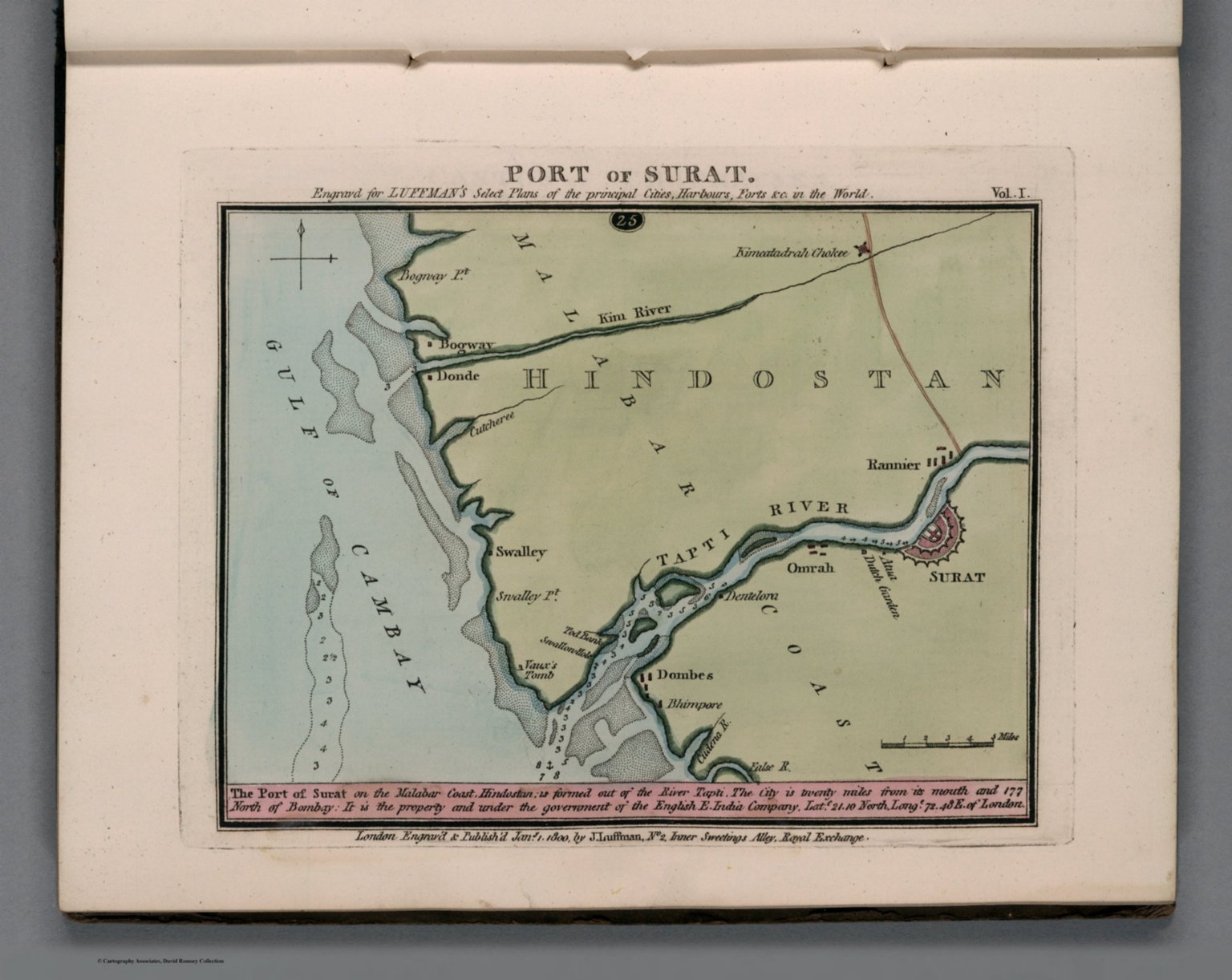
10. Port of Surat. Engraved for Luffman's Select plans of the principal cities, ports, harbours, forts, &c. in the world. London. Engraved and published Jany. 1, 1800, by John Luffman.
- Author
-
Luffman, John, 1756-1846
- Subjects
Military ,Nautical Charts - Abstract
Hand colored chart. Prime meridian is London. Relief shown by hachures. Depth shown by soundings. Includes historical text at the foot of map., Luffman's atlas consists of 2 volumes, including engraved hand colored detailed plans of various cities, harbors and ports around the world, Luffman also included maps of some countries, regions, and islands. Showing roads, railroads, cities, towns, fortifications, rivers and canals. They are engraved and published by John Luffman between 1799 and 1802, often with numbered key. Includes index to each volume and historical text at foot of maps. Relief shown by hachures, pictorially and depth shown by soundings. Bound in light green paper covered boards, with title "J. Luffman plans of fortified cities, forts and harbours, coloured " in gilt pasted on spine., Phillips, 62. Tooley, 404.
- Published
- 1800
Discovery Service for Jio Institute Digital Library
For full access to our library's resources, please sign in.