256 results
Number of results to display per page
Search Results

2. Asie Meridionale : comprenant la presqu'île de l'Inde, la Perse, l'Afghanistan et le Beloutchistan. Paris - 1862. E. Andriveau-Goujon. Rue du Bac. 21. Dressee par A. Vuillemin. Grave le trait et les montagnes par Gerin; les Ecritures par P. Rousset. Les Eaux par Mme. Fontaine. Imp. A. Chardon. (to accompany) Atlas classique et universel de geograparphie ancienne et moderne ... Nouvelle edition. 1863.

- Author
-
Andriveau-Goujon, Eugene, Vuillemin, Alexandre Aime, 1812-1886, Fontaine, Mme., Gerin, Rousset, P., and Chardon, A.
- Subjects
- India, Iran, Afghanistan, Pakistan, South Asia, Asia
- Abstract
Hand color map. Shows political boundaries and possessions of European in South Asia. Relief shown by hachures. Includes explanation., New edition of the classic and universal atlas of ancient and modern geography. Edited and published by J. Andriveau-Goujon in 1863. Adopted by the Minister of War for regimental libraries. Containing 50 plates, 49 hand double page or folding maps, dated 1854-1863, and 1 plate includes Flags of the nations. Some maps on 2 or more plates. Maps showing the most recent exploration, discoveries, and historical work on geography, political and administrative boundaries, major cities, villages, forts, coastal cities, canals, rivers and mountains. Includes descriptive text. In and mountains. Relief shown by hachures and pictorially. Plate 21 has been repeated (21 & 21A) bound after plate 22. Atlas contains descriptive text and index. Handwritten label in pencil indicating the title. Bound in quarter leather brown marbled paper covered boards with a green paper label reading "Atlas classique & universel de geographie ancienne et moderne. Publie par J. Andriveau-Goujon." The spine is embossed with "Andriveau. Atlas universel" in gilt.
- Published
- 1862
3. Box1_45 plate

- Author
-
Anonymous and Bey, Abdürrahim Hilmi
- Subjects
Ottoman Mapping - Abstract
"This is an extraordinary privately assembled encyclopaedia, focused on Mecca as the Navel of the World. Written in manuscript in thin black and red pens in Ottoman language, it contains over 580 pages of manuscript in tiny characters, sometimes accompanied with charts, over 380 manuscript maps, made with extreme care in precision in colours and with gold and silver highlights, over 225 prints from magazines, books, atlases and other sources from the late 19th and early 20th centuries, often joined in collages and compositions with hand-drawn maps. The maps are made with a greatest precision in well planned configuration. The colours are carefully applied to give an instant effect of a modern data visualisation. The gilt highlights and small details in black ink express the author’s endless patience and dedication to the project. The manuscripts, maps and illustrations are tastefully and carefully joined together thematically in foldouts and pamphlets, bound together with linen or paper stripes or strings. Shorter subjects and uncut plates also appear as separate leaves. We could count 217 such separate units. The whole collection is housed in three charming boxes, possibly made by the author from commercial boxes and leftovers of the linen, which he used for drawings of some of the maps. The anonymous author, doubtless a Muslim intellectual, took the information from the contemporary sources and atlases and smartly combined them in his own unique compositions. He also often added his own annotations, colouring and keys to the prints, which he took from the books and magazines. The manuscripts give an impression of a coherent collection, which was probably never meant for a publication. It was possibly an author private project, to which he dedicated years or decades of his life. It is possible that the collection was meant for a private education. Focus on Mecca The maps with geographic, historic and thematic data focus on the Arabian Peninsula with Mecca as a center. Throughout the series the city is often smartly positioned in the middle of the folds, to give the impression, that the world and around it opens like a flower. In the collection we could trace approximately 23 maps, where Mecca is represented in the central point of the world, 24 maps showcasing only the Arabian Peninsula or parts of it or / and the Red Sea, circa 25 maps of Mecca or/and its surroundings and sketches of the Kaaba and 11 views and prints of Mecca. The latter ones have been taken from other publications and integrated into the encyclopaedia by the author. Medina is represented with two manuscript maps and 8 views. The views here are as well taken from other publications. Separate pamphlets also focus on the history of the Arabian Peninsula and the history of its inhabitants with a chart on the tribes of Arabia. With this work the author geographically represented Mecca as the central point, a navel of the global culture and history from the ancient times up to the present days. Other Subjects The pamphlets and fold-outs are bound together thematically and represent the cultures, history and geography of the World from its beginnings until the early 20th century. The manuscript units with maps, charts and illustrations describe subjects such as geology, time through the Ottoman time charts, astronomy and astrology, ancient cultures and monuments (Babylon, Mesopotamia, Ancient Greece, Baalbek etc.), old geographic representations, such as Tabula Peutingeriana and parts of Fra Mauro’s map, America on old maps, discoveries on America and later discoveries and explorations, thematic maps of the world and parts of the world etc. A large portion of the maps is dedicated to the Mediterranean Basement (ca 152 maps) and the Balkans, with the large Ottoman battles. The other maps focus on Asia, America (ca 5 maps of North America, 2 maps of Central America), other continents and the whole world (27 maps of the world). The author seems unattached an ambivalent to Istanbul and Turkey, as the region is almost neglected in the manuscripts, which is the opposite of the contemporary glorification of the newly founded Turkey and the magnificent history of Istanbul. Also hardly represented are the African regions, including the Muslim ones. It is possible, that the author spent most of his life on the Arabian Peninsula and was not attached to the cultural and political center Istanbul. Authorship and Date The author of the work is not signed, neither are the maps dated. According to the attached note, the collection was allegedly connected with the family of the Turkish writer Ahmed Cemil Akıncı (1914-1984). His father and a possible author, Abdürrahim Hilmi Bey (Sipahizâde) was of Sipahi origins from Rumelia and was educated at the Fatih Madrasa in Istanbul. Hilmi Bey was in charge for the railway and education in Egypt, Palestine, Syria and Hejaz, where he spent a large part of his life. This would explain the author’s unattachment to Istanbul and Turkey. The paper, style and material of the boxes indicate the late 1910s and 1920s. Some of the maps confirm this period of time: a series of thematic world maps (possibly drafted after a contemporary Ottoman atlas) showcase the world in 1915 (1331 Rumi years). An illustration from a magazine, representing a map A Child’s Map of the Ancient World, by Alice York and Ilonka Karasz, was published in 1926. It is the youngest dated document, which we could trace in the collection. References: Unrecorded. [S. l., s. d. Possibly Ottoman Empire / Turkey, late 1910s-1920s]. A magnificent hand-written privately assembled encyclopaedia of the World, affectionately assembled and curated by an enlightened Muslim scholar in the last years of the Ottoman Empire, with over 580 text pages and 380 hand drawn detailed maps with gilt highlights, represents Mecca as the Navel of the World and the connecting point between the ancient civilisations and culture and the modern East and West. Collation: 3 red privately custom-made boxes, constructed of thick card with red linen surface with debossed lettering and decoration, patterned paper mounted inside, each with a black cloth loop with a knot, edges originally reinforced with linen, some linen parts with details of manuscript maps, 9 x 14 x 20 cm (3.5 x 5.5 x 7.8 inches). The boxes contain: - 217 separate units of fold-outs (leporellos), pamphlets and maps composed of sheets of paper, privately joined with straps of linen, sporadically also with stripes of paper or bound together with a sting. Most units with 4-8 pp., but also single sheet units and pamphlets with up to 16 pp. manuscript text. Most of the text accompanied with manuscript maps, mostly mounted verso. Some manuscript maps on loose linen waxed paper. Also includes sporadic single prints from books and magazines and postcards, not edited by the author. - The 217 units include: - - Over 580 manuscript text pages, some with charts in text, plus additional text comments and keys. Black and red ink on paper of various quality and thick card, each 18 x 11,5 cm (7 x 4.5 inches) when folded. - - More than 380 manuscript maps, including multiple maps on one sheet and folding maps. The maps are mostly mounted or drawn on cards on the inner side of the fold-outs and pamphlets, on the back of the text sheets. Some manuscript maps on loose waxed linen paper sheets. Most of the maps are ornated with gilt highlights. Black, purple and red ink and water colours on paper and linen paper, from 18 x 11,5 cm to 18 x 44 cm (7 x 4.5 inches to 7 x 17.3 inches), mostly mounted on the back of text pages, but also loose sheets. - - More than 225 prints, mostly mounted in compositions with maps, pictorial panels and more than 35 collages. The prints of various, mostly small sizes include maps, lithographs, chromolithographs, steel engravings, wood-cuts, postcards (cut and uncut), photo-reproductions, illustrations from books and magazines etc. Some prints (mostly illustrations from books and postcards) are added as unedited and uncut sheets. The prints have been taken from mostly Ottoman, but also German, French and English publications. Various techniques, some with manuscript annotations in black ink or with hand colour. - Additional unsorted sheets of manuscript and illustrations. Condition report: Boxes with some staining and minor wear on the edges, manuscripts and maps overall in a good clean condition with minor staining, foxing and wear. Sporadic maps and manuscripts are left unfinished." (Alexander Johnson and Dasa Pahor, 2020)
- Published
- 1918
4. Box3_25 plate

- Author
-
Bey, Abdürrahim Hilmi and Anonymous
- Subjects
Ottoman Mapping - Abstract
"This is an extraordinary privately assembled encyclopaedia, focused on Mecca as the Navel of the World. Written in manuscript in thin black and red pens in Ottoman language, it contains over 580 pages of manuscript in tiny characters, sometimes accompanied with charts, over 380 manuscript maps, made with extreme care in precision in colours and with gold and silver highlights, over 225 prints from magazines, books, atlases and other sources from the late 19th and early 20th centuries, often joined in collages and compositions with hand-drawn maps. The maps are made with a greatest precision in well planned configuration. The colours are carefully applied to give an instant effect of a modern data visualisation. The gilt highlights and small details in black ink express the author’s endless patience and dedication to the project. The manuscripts, maps and illustrations are tastefully and carefully joined together thematically in foldouts and pamphlets, bound together with linen or paper stripes or strings. Shorter subjects and uncut plates also appear as separate leaves. We could count 217 such separate units. The whole collection is housed in three charming boxes, possibly made by the author from commercial boxes and leftovers of the linen, which he used for drawings of some of the maps. The anonymous author, doubtless a Muslim intellectual, took the information from the contemporary sources and atlases and smartly combined them in his own unique compositions. He also often added his own annotations, colouring and keys to the prints, which he took from the books and magazines. The manuscripts give an impression of a coherent collection, which was probably never meant for a publication. It was possibly an author private project, to which he dedicated years or decades of his life. It is possible that the collection was meant for a private education. Focus on Mecca The maps with geographic, historic and thematic data focus on the Arabian Peninsula with Mecca as a center. Throughout the series the city is often smartly positioned in the middle of the folds, to give the impression, that the world and around it opens like a flower. In the collection we could trace approximately 23 maps, where Mecca is represented in the central point of the world, 24 maps showcasing only the Arabian Peninsula or parts of it or / and the Red Sea, circa 25 maps of Mecca or/and its surroundings and sketches of the Kaaba and 11 views and prints of Mecca. The latter ones have been taken from other publications and integrated into the encyclopaedia by the author. Medina is represented with two manuscript maps and 8 views. The views here are as well taken from other publications. Separate pamphlets also focus on the history of the Arabian Peninsula and the history of its inhabitants with a chart on the tribes of Arabia. With this work the author geographically represented Mecca as the central point, a navel of the global culture and history from the ancient times up to the present days. Other Subjects The pamphlets and fold-outs are bound together thematically and represent the cultures, history and geography of the World from its beginnings until the early 20th century. The manuscript units with maps, charts and illustrations describe subjects such as geology, time through the Ottoman time charts, astronomy and astrology, ancient cultures and monuments (Babylon, Mesopotamia, Ancient Greece, Baalbek etc.), old geographic representations, such as Tabula Peutingeriana and parts of Fra Mauro’s map, America on old maps, discoveries on America and later discoveries and explorations, thematic maps of the world and parts of the world etc. A large portion of the maps is dedicated to the Mediterranean Basement (ca 152 maps) and the Balkans, with the large Ottoman battles. The other maps focus on Asia, America (ca 5 maps of North America, 2 maps of Central America), other continents and the whole world (27 maps of the world). The author seems unattached an ambivalent to Istanbul and Turkey, as the region is almost neglected in the manuscripts, which is the opposite of the contemporary glorification of the newly founded Turkey and the magnificent history of Istanbul. Also hardly represented are the African regions, including the Muslim ones. It is possible, that the author spent most of his life on the Arabian Peninsula and was not attached to the cultural and political center Istanbul. Authorship and Date The author of the work is not signed, neither are the maps dated. According to the attached note, the collection was allegedly connected with the family of the Turkish writer Ahmed Cemil Akıncı (1914-1984). His father and a possible author, Abdürrahim Hilmi Bey (Sipahizâde) was of Sipahi origins from Rumelia and was educated at the Fatih Madrasa in Istanbul. Hilmi Bey was in charge for the railway and education in Egypt, Palestine, Syria and Hejaz, where he spent a large part of his life. This would explain the author’s unattachment to Istanbul and Turkey. The paper, style and material of the boxes indicate the late 1910s and 1920s. Some of the maps confirm this period of time: a series of thematic world maps (possibly drafted after a contemporary Ottoman atlas) showcase the world in 1915 (1331 Rumi years). An illustration from a magazine, representing a map A Child’s Map of the Ancient World, by Alice York and Ilonka Karasz, was published in 1926. It is the youngest dated document, which we could trace in the collection. References: Unrecorded. [S. l., s. d. Possibly Ottoman Empire / Turkey, late 1910s-1920s]. A magnificent hand-written privately assembled encyclopaedia of the World, affectionately assembled and curated by an enlightened Muslim scholar in the last years of the Ottoman Empire, with over 580 text pages and 380 hand drawn detailed maps with gilt highlights, represents Mecca as the Navel of the World and the connecting point between the ancient civilisations and culture and the modern East and West. Collation: 3 red privately custom-made boxes, constructed of thick card with red linen surface with debossed lettering and decoration, patterned paper mounted inside, each with a black cloth loop with a knot, edges originally reinforced with linen, some linen parts with details of manuscript maps, 9 x 14 x 20 cm (3.5 x 5.5 x 7.8 inches). The boxes contain: - 217 separate units of fold-outs (leporellos), pamphlets and maps composed of sheets of paper, privately joined with straps of linen, sporadically also with stripes of paper or bound together with a sting. Most units with 4-8 pp., but also single sheet units and pamphlets with up to 16 pp. manuscript text. Most of the text accompanied with manuscript maps, mostly mounted verso. Some manuscript maps on loose linen waxed paper. Also includes sporadic single prints from books and magazines and postcards, not edited by the author. - The 217 units include: - - Over 580 manuscript text pages, some with charts in text, plus additional text comments and keys. Black and red ink on paper of various quality and thick card, each 18 x 11,5 cm (7 x 4.5 inches) when folded. - - More than 380 manuscript maps, including multiple maps on one sheet and folding maps. The maps are mostly mounted or drawn on cards on the inner side of the fold-outs and pamphlets, on the back of the text sheets. Some manuscript maps on loose waxed linen paper sheets. Most of the maps are ornated with gilt highlights. Black, purple and red ink and water colours on paper and linen paper, from 18 x 11,5 cm to 18 x 44 cm (7 x 4.5 inches to 7 x 17.3 inches), mostly mounted on the back of text pages, but also loose sheets. - - More than 225 prints, mostly mounted in compositions with maps, pictorial panels and more than 35 collages. The prints of various, mostly small sizes include maps, lithographs, chromolithographs, steel engravings, wood-cuts, postcards (cut and uncut), photo-reproductions, illustrations from books and magazines etc. Some prints (mostly illustrations from books and postcards) are added as unedited and uncut sheets. The prints have been taken from mostly Ottoman, but also German, French and English publications. Various techniques, some with manuscript annotations in black ink or with hand colour. - Additional unsorted sheets of manuscript and illustrations. Condition report: Boxes with some staining and minor wear on the edges, manuscripts and maps overall in a good clean condition with minor staining, foxing and wear. Sporadic maps and manuscripts are left unfinished." (Alexander Johnson and Dasa Pahor, 2020)
- Published
- 1918
5. Box2_43 plate

- Author
-
Bey, Abdürrahim Hilmi and Anonymous
- Subjects
Ottoman Mapping - Abstract
"This is an extraordinary privately assembled encyclopaedia, focused on Mecca as the Navel of the World. Written in manuscript in thin black and red pens in Ottoman language, it contains over 580 pages of manuscript in tiny characters, sometimes accompanied with charts, over 380 manuscript maps, made with extreme care in precision in colours and with gold and silver highlights, over 225 prints from magazines, books, atlases and other sources from the late 19th and early 20th centuries, often joined in collages and compositions with hand-drawn maps. The maps are made with a greatest precision in well planned configuration. The colours are carefully applied to give an instant effect of a modern data visualisation. The gilt highlights and small details in black ink express the author’s endless patience and dedication to the project. The manuscripts, maps and illustrations are tastefully and carefully joined together thematically in foldouts and pamphlets, bound together with linen or paper stripes or strings. Shorter subjects and uncut plates also appear as separate leaves. We could count 217 such separate units. The whole collection is housed in three charming boxes, possibly made by the author from commercial boxes and leftovers of the linen, which he used for drawings of some of the maps. The anonymous author, doubtless a Muslim intellectual, took the information from the contemporary sources and atlases and smartly combined them in his own unique compositions. He also often added his own annotations, colouring and keys to the prints, which he took from the books and magazines. The manuscripts give an impression of a coherent collection, which was probably never meant for a publication. It was possibly an author private project, to which he dedicated years or decades of his life. It is possible that the collection was meant for a private education. Focus on Mecca The maps with geographic, historic and thematic data focus on the Arabian Peninsula with Mecca as a center. Throughout the series the city is often smartly positioned in the middle of the folds, to give the impression, that the world and around it opens like a flower. In the collection we could trace approximately 23 maps, where Mecca is represented in the central point of the world, 24 maps showcasing only the Arabian Peninsula or parts of it or / and the Red Sea, circa 25 maps of Mecca or/and its surroundings and sketches of the Kaaba and 11 views and prints of Mecca. The latter ones have been taken from other publications and integrated into the encyclopaedia by the author. Medina is represented with two manuscript maps and 8 views. The views here are as well taken from other publications. Separate pamphlets also focus on the history of the Arabian Peninsula and the history of its inhabitants with a chart on the tribes of Arabia. With this work the author geographically represented Mecca as the central point, a navel of the global culture and history from the ancient times up to the present days. Other Subjects The pamphlets and fold-outs are bound together thematically and represent the cultures, history and geography of the World from its beginnings until the early 20th century. The manuscript units with maps, charts and illustrations describe subjects such as geology, time through the Ottoman time charts, astronomy and astrology, ancient cultures and monuments (Babylon, Mesopotamia, Ancient Greece, Baalbek etc.), old geographic representations, such as Tabula Peutingeriana and parts of Fra Mauro’s map, America on old maps, discoveries on America and later discoveries and explorations, thematic maps of the world and parts of the world etc. A large portion of the maps is dedicated to the Mediterranean Basement (ca 152 maps) and the Balkans, with the large Ottoman battles. The other maps focus on Asia, America (ca 5 maps of North America, 2 maps of Central America), other continents and the whole world (27 maps of the world). The author seems unattached an ambivalent to Istanbul and Turkey, as the region is almost neglected in the manuscripts, which is the opposite of the contemporary glorification of the newly founded Turkey and the magnificent history of Istanbul. Also hardly represented are the African regions, including the Muslim ones. It is possible, that the author spent most of his life on the Arabian Peninsula and was not attached to the cultural and political center Istanbul. Authorship and Date The author of the work is not signed, neither are the maps dated. According to the attached note, the collection was allegedly connected with the family of the Turkish writer Ahmed Cemil Akıncı (1914-1984). His father and a possible author, Abdürrahim Hilmi Bey (Sipahizâde) was of Sipahi origins from Rumelia and was educated at the Fatih Madrasa in Istanbul. Hilmi Bey was in charge for the railway and education in Egypt, Palestine, Syria and Hejaz, where he spent a large part of his life. This would explain the author’s unattachment to Istanbul and Turkey. The paper, style and material of the boxes indicate the late 1910s and 1920s. Some of the maps confirm this period of time: a series of thematic world maps (possibly drafted after a contemporary Ottoman atlas) showcase the world in 1915 (1331 Rumi years). An illustration from a magazine, representing a map A Child’s Map of the Ancient World, by Alice York and Ilonka Karasz, was published in 1926. It is the youngest dated document, which we could trace in the collection. References: Unrecorded. [S. l., s. d. Possibly Ottoman Empire / Turkey, late 1910s-1920s]. A magnificent hand-written privately assembled encyclopaedia of the World, affectionately assembled and curated by an enlightened Muslim scholar in the last years of the Ottoman Empire, with over 580 text pages and 380 hand drawn detailed maps with gilt highlights, represents Mecca as the Navel of the World and the connecting point between the ancient civilisations and culture and the modern East and West. Collation: 3 red privately custom-made boxes, constructed of thick card with red linen surface with debossed lettering and decoration, patterned paper mounted inside, each with a black cloth loop with a knot, edges originally reinforced with linen, some linen parts with details of manuscript maps, 9 x 14 x 20 cm (3.5 x 5.5 x 7.8 inches). The boxes contain: - 217 separate units of fold-outs (leporellos), pamphlets and maps composed of sheets of paper, privately joined with straps of linen, sporadically also with stripes of paper or bound together with a sting. Most units with 4-8 pp., but also single sheet units and pamphlets with up to 16 pp. manuscript text. Most of the text accompanied with manuscript maps, mostly mounted verso. Some manuscript maps on loose linen waxed paper. Also includes sporadic single prints from books and magazines and postcards, not edited by the author. - The 217 units include: - - Over 580 manuscript text pages, some with charts in text, plus additional text comments and keys. Black and red ink on paper of various quality and thick card, each 18 x 11,5 cm (7 x 4.5 inches) when folded. - - More than 380 manuscript maps, including multiple maps on one sheet and folding maps. The maps are mostly mounted or drawn on cards on the inner side of the fold-outs and pamphlets, on the back of the text sheets. Some manuscript maps on loose waxed linen paper sheets. Most of the maps are ornated with gilt highlights. Black, purple and red ink and water colours on paper and linen paper, from 18 x 11,5 cm to 18 x 44 cm (7 x 4.5 inches to 7 x 17.3 inches), mostly mounted on the back of text pages, but also loose sheets. - - More than 225 prints, mostly mounted in compositions with maps, pictorial panels and more than 35 collages. The prints of various, mostly small sizes include maps, lithographs, chromolithographs, steel engravings, wood-cuts, postcards (cut and uncut), photo-reproductions, illustrations from books and magazines etc. Some prints (mostly illustrations from books and postcards) are added as unedited and uncut sheets. The prints have been taken from mostly Ottoman, but also German, French and English publications. Various techniques, some with manuscript annotations in black ink or with hand colour. - Additional unsorted sheets of manuscript and illustrations. Condition report: Boxes with some staining and minor wear on the edges, manuscripts and maps overall in a good clean condition with minor staining, foxing and wear. Sporadic maps and manuscripts are left unfinished." (Alexander Johnson and Dasa Pahor, 2020)
- Published
- 1918
6. Box1_45 plate
- Author
-
Anonymous and Bey, Abdürrahim Hilmi
- Subjects
Ottoman Mapping - Abstract
"This is an extraordinary privately assembled encyclopaedia, focused on Mecca as the Navel of the World. Written in manuscript in thin black and red pens in Ottoman language, it contains over 580 pages of manuscript in tiny characters, sometimes accompanied with charts, over 380 manuscript maps, made with extreme care in precision in colours and with gold and silver highlights, over 225 prints from magazines, books, atlases and other sources from the late 19th and early 20th centuries, often joined in collages and compositions with hand-drawn maps. The maps are made with a greatest precision in well planned configuration. The colours are carefully applied to give an instant effect of a modern data visualisation. The gilt highlights and small details in black ink express the author’s endless patience and dedication to the project. The manuscripts, maps and illustrations are tastefully and carefully joined together thematically in foldouts and pamphlets, bound together with linen or paper stripes or strings. Shorter subjects and uncut plates also appear as separate leaves. We could count 217 such separate units. The whole collection is housed in three charming boxes, possibly made by the author from commercial boxes and leftovers of the linen, which he used for drawings of some of the maps. The anonymous author, doubtless a Muslim intellectual, took the information from the contemporary sources and atlases and smartly combined them in his own unique compositions. He also often added his own annotations, colouring and keys to the prints, which he took from the books and magazines. The manuscripts give an impression of a coherent collection, which was probably never meant for a publication. It was possibly an author private project, to which he dedicated years or decades of his life. It is possible that the collection was meant for a private education. Focus on Mecca The maps with geographic, historic and thematic data focus on the Arabian Peninsula with Mecca as a center. Throughout the series the city is often smartly positioned in the middle of the folds, to give the impression, that the world and around it opens like a flower. In the collection we could trace approximately 23 maps, where Mecca is represented in the central point of the world, 24 maps showcasing only the Arabian Peninsula or parts of it or / and the Red Sea, circa 25 maps of Mecca or/and its surroundings and sketches of the Kaaba and 11 views and prints of Mecca. The latter ones have been taken from other publications and integrated into the encyclopaedia by the author. Medina is represented with two manuscript maps and 8 views. The views here are as well taken from other publications. Separate pamphlets also focus on the history of the Arabian Peninsula and the history of its inhabitants with a chart on the tribes of Arabia. With this work the author geographically represented Mecca as the central point, a navel of the global culture and history from the ancient times up to the present days. Other Subjects The pamphlets and fold-outs are bound together thematically and represent the cultures, history and geography of the World from its beginnings until the early 20th century. The manuscript units with maps, charts and illustrations describe subjects such as geology, time through the Ottoman time charts, astronomy and astrology, ancient cultures and monuments (Babylon, Mesopotamia, Ancient Greece, Baalbek etc.), old geographic representations, such as Tabula Peutingeriana and parts of Fra Mauro’s map, America on old maps, discoveries on America and later discoveries and explorations, thematic maps of the world and parts of the world etc. A large portion of the maps is dedicated to the Mediterranean Basement (ca 152 maps) and the Balkans, with the large Ottoman battles. The other maps focus on Asia, America (ca 5 maps of North America, 2 maps of Central America), other continents and the whole world (27 maps of the world). The author seems unattached an ambivalent to Istanbul and Turkey, as the region is almost neglected in the manuscripts, which is the opposite of the contemporary glorification of the newly founded Turkey and the magnificent history of Istanbul. Also hardly represented are the African regions, including the Muslim ones. It is possible, that the author spent most of his life on the Arabian Peninsula and was not attached to the cultural and political center Istanbul. Authorship and Date The author of the work is not signed, neither are the maps dated. According to the attached note, the collection was allegedly connected with the family of the Turkish writer Ahmed Cemil Akıncı (1914-1984). His father and a possible author, Abdürrahim Hilmi Bey (Sipahizâde) was of Sipahi origins from Rumelia and was educated at the Fatih Madrasa in Istanbul. Hilmi Bey was in charge for the railway and education in Egypt, Palestine, Syria and Hejaz, where he spent a large part of his life. This would explain the author’s unattachment to Istanbul and Turkey. The paper, style and material of the boxes indicate the late 1910s and 1920s. Some of the maps confirm this period of time: a series of thematic world maps (possibly drafted after a contemporary Ottoman atlas) showcase the world in 1915 (1331 Rumi years). An illustration from a magazine, representing a map A Child’s Map of the Ancient World, by Alice York and Ilonka Karasz, was published in 1926. It is the youngest dated document, which we could trace in the collection. References: Unrecorded. [S. l., s. d. Possibly Ottoman Empire / Turkey, late 1910s-1920s]. A magnificent hand-written privately assembled encyclopaedia of the World, affectionately assembled and curated by an enlightened Muslim scholar in the last years of the Ottoman Empire, with over 580 text pages and 380 hand drawn detailed maps with gilt highlights, represents Mecca as the Navel of the World and the connecting point between the ancient civilisations and culture and the modern East and West. Collation: 3 red privately custom-made boxes, constructed of thick card with red linen surface with debossed lettering and decoration, patterned paper mounted inside, each with a black cloth loop with a knot, edges originally reinforced with linen, some linen parts with details of manuscript maps, 9 x 14 x 20 cm (3.5 x 5.5 x 7.8 inches). The boxes contain: - 217 separate units of fold-outs (leporellos), pamphlets and maps composed of sheets of paper, privately joined with straps of linen, sporadically also with stripes of paper or bound together with a sting. Most units with 4-8 pp., but also single sheet units and pamphlets with up to 16 pp. manuscript text. Most of the text accompanied with manuscript maps, mostly mounted verso. Some manuscript maps on loose linen waxed paper. Also includes sporadic single prints from books and magazines and postcards, not edited by the author. - The 217 units include: - - Over 580 manuscript text pages, some with charts in text, plus additional text comments and keys. Black and red ink on paper of various quality and thick card, each 18 x 11,5 cm (7 x 4.5 inches) when folded. - - More than 380 manuscript maps, including multiple maps on one sheet and folding maps. The maps are mostly mounted or drawn on cards on the inner side of the fold-outs and pamphlets, on the back of the text sheets. Some manuscript maps on loose waxed linen paper sheets. Most of the maps are ornated with gilt highlights. Black, purple and red ink and water colours on paper and linen paper, from 18 x 11,5 cm to 18 x 44 cm (7 x 4.5 inches to 7 x 17.3 inches), mostly mounted on the back of text pages, but also loose sheets. - - More than 225 prints, mostly mounted in compositions with maps, pictorial panels and more than 35 collages. The prints of various, mostly small sizes include maps, lithographs, chromolithographs, steel engravings, wood-cuts, postcards (cut and uncut), photo-reproductions, illustrations from books and magazines etc. Some prints (mostly illustrations from books and postcards) are added as unedited and uncut sheets. The prints have been taken from mostly Ottoman, but also German, French and English publications. Various techniques, some with manuscript annotations in black ink or with hand colour. - Additional unsorted sheets of manuscript and illustrations. Condition report: Boxes with some staining and minor wear on the edges, manuscripts and maps overall in a good clean condition with minor staining, foxing and wear. Sporadic maps and manuscripts are left unfinished." (Alexander Johnson, 2020)
- Published
- 1918
7. A Royal Lion Hunt
- Author
-
Museum of Fine Arts, Boston
- Subjects
- India
- Published
- 1650
8. Hindoostan. Drawn by A. Arrowsmith. Engraved by Sy. Hall. 14 Bury Stt. Bloomsby. Published, 1817, by A. Constable & Co. Edinburgh and Longman & Compy., London.

- Author
-
Arrowsmith, Aaron, Corbould, H., Heath, Chas., Hall, S., and Thomson & Hall.
- Subjects
- India, London
- Abstract
First edition of Arrowsmith atlas published in 1817. Although the maps are not large, they are dense with information. This complete atlas features index and 53 copperplate maps, drawn by Arrowsmith and engraved by Sidney Hall, with a few engraved by Thomson in collaboration with Hall. The maps include two world, 29 related to Europe and Scandinavia, 16 on Asia, Africa, and Oceania, and six related to the Americas. The United States map shows Georgia extending from the coast to the Mississippi River. The area west of the Mississippi is blank and labeled Louisiana. Engraved title page has Atlas holding the globe above two putti, one sailing a dingy, the other engaged in cartographic studies with a globe, map and dividers. Hardbound with marbled paper and original paper label printed with "Arrowsmith's New General Atlas Comprehended in Fifty three Maps From Original Drawings. Price L 2,12,6. coloured". Black leather spine has a label embossed with "Atlas (18)17" in gilt. Maps have original outline color, with many tissue guards still in place., First edition of Arrowsmith atlas published in 1817. This complete atlas features index and 53 copperplate maps, drawn by Arrowsmith and engraved by Sidney Hall, with a few engraved by Thomson in collaboration with Hall. The maps include two world, 29 related to Europe and Scandinavia, 16 on Asia, Africa, and Oceania, and six related to the Americas. The United States map shows Georgia extending from the coast to the Mississippi River. The area west of the Mississippi is blank and labeled Louisiana. Engraved title page has Atlas holding the globe above two putti, one sailing a dingy, the other engaged in cartographic studies with a globe, map and dividers. Hardbound with marbled paper and original paper label printed with "Arrowsmith's New General Atlas Comprehended in Fifty three Maps From Original Drawings. Price L 2,12,6. coloured". Black leather spine has a label embossed with "Atlas (18)17" in gilt. Maps have original outline color, with many tissue guards still in place.
- Published
- 1817
9. Asie Meridionale, Inde Anglaise et Indo-Chine. Atlas spheroidal & universel de geographie dresse par F.A. Garnier, geographe. Paris, Ve. Jules Renouard, Editeur, r. de Tournon, no. 6. 1860. Imp. de Louis Antoine, Rue de Cluny, 1, Paris.

- Author
-
Garnier, F. A., 1803-1863, Antoine, Louis, and P.-A. Bourdier et Cie.
- Subjects
- India, Paris, South Asia, Southeast Asia, Asia
- Abstract
Full col. Relief shown by hachures. Prime meridian: Paris. On globe in cartouche: Sphericite de la terre., This atlas is exceptional for its "spheroidal" maps of the globe, showing the various continents and poles, shaded to give the effect of a sphere floating in space. The remaining maps are also very well executed and colored, mostly by hand, a few in colored litho. In recent years, this atlas has become rare in the trade. This is the only atlas that Garnier produced, according to Phillips. Tooley lists an 1860 edition. Covers are quarter leather marbled paper covered boards with a paper label; the burgundy leather spine is embossed with "F.A. Garnier. Atlas Universel et Spheroidal de Geographie" in gilt. On verso of half-title: Paris -- Imprimerie de P.-A. Bourdier et Cie., Rue Mazarine, 30., Phillips, 836.
- Published
- 1862
10. Hindostan. Neele sculp. Published Jany. 1st. 1819, by Pinnock & Maunder Strand.

- Author
-
Pawley, Neele, Samuel John, 1758-1824, Neele, George, Pinnock and Maunder, and Samuel & George Neele
- Subjects
- India, London
- Abstract
Map of Hindostan [India] and vicinity. Shows political boundaries (including British colonies), cities, railroads, topography, major lakes and drainage, coastlines and islands. Relief shown with hachures. Indexed and includes latitudinal and longitudinal lines, as well as a compass rose and bar scale, given in British statute miles. Hand-colored engraving, including illustration of clouds behind title. Map is 29 x 22 cm, on sheet 34 x 26 cm., Pawley's minor atlas, published in London by G. and W. B. Whittaker, 1822. Bound in board, covered with faded red and blue marbled papers. End papers comprised of the same marbling, but not faded. With leather spine and corners. Gilded spine title: Pawley's minor atlas. Collation: 2° : [1] page, [2] plates, I-XXXVI, [XXXVII], XXXVIII-XLIII leaves of plates, [1] page. First and last pages are blank. Forty-three plates containing 43 maps. All double plates except for II-V. Engraved title page and index. Title page dated 1822; Index and all maps dated 1819, with the exception of the map on plate XVII, which is dated 1823. Maps dated 1819 have the imprint Pinnock & Co. Strand or Pinnock & Maunder Strand. Maps show political boundaries, cities, railroads, routes, topography, deserts, vegetation, major lakes and drainage, coastlines and islands. Maps of North America also feature the indigenous peoples living therein. Maps include latitudinal and longitudinal lines, as well as compass roses, bar scales and historical notes. Hand-colored engravings.
- Published
- 1819
11. Peninsula of India. Neele sculp. Published Jany. 1st. 1819, by Pinnock & Maunder Strand.

- Author
-
Pawley, Neele, Samuel John, 1758-1824, Neele, George, Pinnock and Maunder, and Samuel & George Neele
- Subjects
- India, London
- Abstract
Map of the Indian subcontinent and vicinity. Shows political boundaries (including British colonies), cities, railroads, topography, major lakes and drainage, coastlines and islands. Relief shown with hachures. Indexed and includes latitudinal and longitudinal lines, as well as a compass rose and bar scale, given in British statute miles. Hand-colored engraving, including illustration of clouds and sunbeams behind title. Map is 27 x 21 cm, on sheet 34 x 26 cm., Pawley's minor atlas, published in London by G. and W. B. Whittaker, 1822. Bound in board, covered with faded red and blue marbled papers. End papers comprised of the same marbling, but not faded. With leather spine and corners. Gilded spine title: Pawley's minor atlas. Collation: 2° : [1] page, [2] plates, I-XXXVI, [XXXVII], XXXVIII-XLIII leaves of plates, [1] page. First and last pages are blank. Forty-three plates containing 43 maps. All double plates except for II-V. Engraved title page and index. Title page dated 1822; Index and all maps dated 1819, with the exception of the map on plate XVII, which is dated 1823. Maps dated 1819 have the imprint Pinnock & Co. Strand or Pinnock & Maunder Strand. Maps show political boundaries, cities, railroads, routes, topography, deserts, vegetation, major lakes and drainage, coastlines and islands. Maps of North America also feature the indigenous peoples living therein. Maps include latitudinal and longitudinal lines, as well as compass roses, bar scales and historical notes. Hand-colored engravings.
- Published
- 1819
12. India. (to accompany) Atlas Of Global Geography. By Erwin Raisz. Lectures in Cartography, Institute Of Geographical Exploration, Harvard University, Cambridge, Mass. ... Global Press Corporation, Publishers. New York, N.Y. Sole Distributors: Harper & Brothers, New York. (on verso) Copyright 1944, by Global Press Corporation.

- Author
-
Raisz, Erwin
- Subjects
- India, New York
- Abstract
Color maps. Accompanied by text, charts, and ills. Relief shown pictorially and by gradient tints. With paper dust jacket. On the jacket it states that this is an "entirely new kind of atlas - A beautiful and informative book of 'global' maps, giving a plane's-eye view of tomorrow's geography...", Maps in color. With paper dust jacket. On the jacket it states that this is an "entirely new kind of atlas - A beautiful and informative book of 'global' maps, giving a plane's-eye view of tomorrow's geography..." Inside dust jacket's back cover: short biography of Dr. Edwin Raisz, Photo by Backarch. Raisz perfected a unique style of hand drawn cartography that was a great contribution to 20th century cartography. More information about him may be found at www. raiszmaps.com, P7191.
- Published
- 1944
13. Hindoostan. 66. (1848)

- Author
-
Bourquin, Frederick, Mitchell, Samuel Augustus, and Tanner, Henry S.
- Subjects
- India, Sri Lanka, Philadelphia, Asia
- Abstract
Lithographed. Relief shown with hachures. Inset of the Delta of the Ganges. Table of British and Independent States keyed to map. Table of French, Portugese, and Danish territories., This is a unique copy of the Mitchell/Tanner Universal Atlas. Frederick Bourquin and his employer, Peter Duval, received a Third Premium Award from the Franklin Institute in November, 1848, for their achievement in transferring the Universal Atlas from copper plates to lithographic stones. The catalog of the exhibition lists it as "No. 52. Universal Atlas in folio, a most beautiful specimen of the art of transferring and lithographic printing, from the press of P.S. Duval, Philadelphia, transferred by Bourquin." This copy of the atlas was their submission to the Franklin Institute to be considered for the award. It is made up of sheets from the atlas, all uncolored, all oversized, and all taken from various editions of the atlas from 1846 to 1848 (one map is dated 1849, but we believe it was issued in late 1848). It appears that these sheets were offprints that remained in the lithographer's shop and that the atlas was made up from them. Atlas is bound in half leather marbled paper covered boards with leather label on the front reading "Atlas Transferred From Copper To And Printed From Stone By Frederick Bourquin." The atlas stayed with the Franklin Institute, each page having the Institute's stamp on it, and was eventually sold by the Institute in the mid twentieth century. There are several erasures of dates that are earlier than 1848 (perhaps an attempt to make the book seem up to date) and several erasures of Tanner's name (on the title page) to conform to the fact that in 1848 this was known as Mitchell's atlas. The map borders vary between the "Mitchell" and the "Tanner" borders. And the paper thickness and quality varies as well. These sheets may have been some of the first "pulls" of each map in the various 1846-48 editions. This is a fascinating compilation and throws light on the transition in printing from copper plate to lithographic stone., Ristow p. 311 (award actually received in 1848).
- Published
- 1848
14. Hindoostan. Drawn by J. Wyld. (engraved by) Hewitt Sc. ... Published by John Thomson & Co. Edinburgh. (to accompany) A General Atlas, Containing Maps illustrating some important periods in Ancient History; and distinct Maps of the several Empires, Kingdoms and States In The World, From Original Drawings according to the latest Treaties by J. Wyld and Engraved by N.R. Hewitt. Edinburgh, Printed for John Thomson & Co for Baldwin, Cradock & Joy, London & John Cumming, Dublin.

- Author
-
Thomson, John, Wyld, James, 1790-1836, Lizars, W.H., and Hewitt, N.R.
- Subjects
Classical - Abstract
Detailed map, with outline colored boundaries. With a vignette "View of Calcutta from Ft. William". Includes reference to colors, showing provinces, and settlements. The atlas is the second edition and includes the extra map of the Arctic and two extra maps of Australia. The text adds a section on Voyages of Discovery. Two additional maps are laid in, one of South America, the other of Mexico. Each map has a small vignette illustrating a subject related to the map. Half leather paper-covered boards with label pasted on front printed with title. Prime meridian is Greenwich. Relief shown pictorially., This is the second edition and includes the extra map of the Arctic and two extra maps of Australia. The text adds a section on Voyages of Discovery. Two additional maps are laid in, one of South America, the other of Mexico. Half leather paper-covered boards with label pasted on front printed with title., cfP6043.
- Published
- 1824
15. Geographical, Historical, and Statistical Map of India. Hindoostan; or, India: Drawn from the Most Recent Authorities, for the Illustration of Lavoisne's Genealogical, Historical, Chronological, and Geographical Atlas, by J. Aspin. 1820. No. 65. Published by M. Carey & Son. Philad. 1820. Kneass, Sc. Philadelphia, 1820 - Printed by T.H. Palmer, for M. Carey & Son, from the London edition of 1817, with corrections & additions.

- Author
-
Carey, Mathew, Lavoisne, M., and T. H. Palmer
- Subjects
- India, Sri Lanka, Philadelphia
- Abstract
Text provides a history and description of India. Locations of battles and seiges shown in chronological lists keyed to little flags on the maps. Full color map. Relief shown with sketches., This is the first American edition which is based on the 1817 London edition published by J. Barfield (see our 1814 Barfield edition). Full color. Bound in half leather brown boards with gold stamped title on the spine reading "Lavoisne. Genealogical, Historical, Chronological And Geographical Atlas.", cfP131.
- Published
- 1820
16. Peking. Kalkutta. Innerasien, Indien, China. Gotha : Justus Perthes. Sydow-Wagners method. Schul-Atlas. XXII.

- Author
-
Sydow, Emil von., 1812-1873, Wagner, Hermann, 1840-1929, Haack, Hermann, 1872-1966, Lautensach, Hermann, 1886-1971, and Stollt, O.
- Subjects
- Beijing (China), Calcutta (India), India, China
- Abstract
2 city plans on 1 sheet., 1943. 22nd. Edition of Sydow-Wagner's methodical school atlas of the world. Edited by H. Haack and H. Lautensach. cartographically reviewed and revised by O. Stollt, published by Justus Perthes in Gotha, 1943. Contains 15 pages of text, and 61 double-page colored map pages, 59 main map and 258 secondary maps, in variable scales. Maps include color coded reference, text, legend, secondary title page, some with location map and index. Atlas consists of political and thematic maps, city plans and views. Showing political boundaries, major cities, towns, roads, railroads, telegraph cables, rivers, lakes shipping routes, distances, rivers and mountains. Also showing routes of voyages and discovery. Relief shown by hachures, spot heights and gradient tints. Depth shown by bathymetric tints, isolines and soundings. Prime meridian: Greenwich. Bound in hard cover green paper with linen spine and title “Sydow-Wagners methodischer Schul-Atlas, Justus Perthes”. Atlas accompanied by supplemental alphabetical index: “Namenverzeichniz” in 38 pages. In lower left: L/0998.
- Published
- 1943
17. Innerasien, Indien, China. Gotha : Justus Perthes. Sydow-Wagners method. Schul-Atlas. XXII.

- Author
-
Sydow, Emil von., 1812-1873, Wagner, Hermann, 1840-1929, Haack, Hermann, 1872-1966, Lautensach, Hermann, 1886-1971, and Stollt, O.
- Subjects
Physical - Abstract
Map of Inner Asiaian countries. Bonne'sche Projektion., 1943. 22nd. Edition of Sydow-Wagner's methodical school atlas of the world. Edited by H. Haack and H. Lautensach. cartographically reviewed and revised by O. Stollt, published by Justus Perthes in Gotha, 1943. Contains 15 pages of text, and 61 double-page colored map pages, 59 main map and 258 secondary maps, in variable scales. Maps include color coded reference, text, legend, secondary title page, some with location map and index. Atlas consists of political and thematic maps, city plans and views. Showing political boundaries, major cities, towns, roads, railroads, telegraph cables, rivers, lakes shipping routes, distances, rivers and mountains. Also showing routes of voyages and discovery. Relief shown by hachures, spot heights and gradient tints. Depth shown by bathymetric tints, isolines and soundings. Prime meridian: Greenwich. Bound in hard cover green paper with linen spine and title “Sydow-Wagners methodischer Schul-Atlas, Justus Perthes”. Atlas accompanied by supplemental alphabetical index: “Namenverzeichniz” in 38 pages. In lower left: L/0998.
- Published
- 1943
18. India.

- Author
-
Cram, George Franklin, 1841-1928
- Subjects
Railroad - Abstract
Map of India. Shows political boundaries, cities, railroads, topography, bodies of water, drainage, coastlines and islands. Relief shown with hachures. Includes latitudinal and longitudinal lines, as well as a bar scale given in miles. Provides figures for square milage and population. Map indexed to indicate place names. Inset map: South eastern provinces of India (or Further India). Colored lithograph. Map is 40 x 27 cm, on sheet 45 x 33 cm., Cram's standard American railway system atlas of the world, by George F. Cram; published in New York and Chicago, 1899. Bound in dark teal-colored board, which has been reinforced with duct tape. Front cover includes title, advertisement and "Index to United States, Canada and Mexico maps". With green floral end papers. Collation: 2° : [1-4], 5-510, 515-608, [1-42] pages. Atlas comprised of 231 maps, with geographic coverage of the United States as a whole and each of its fifty states, as well as Canada, Central America, South America, the West Indies, Europe, the Middle East, Asia, Africa, the East Indies, Australia and New Zealand. Also, with several city maps, including San Francisco, New York, Philadelphia, Detroit, Atlanta, Dallas and Denver. Maps show political boundaries, counties, towns, Indian reservations, mines, railroads, roads, steamship lines, topography, bodies of water, drainage, coastlines, islands and water routes with distances. Some maps provide figures for square mileage and population. Volume includes title page, table of contents, and index pages associated with state maps, as well as 42 (unnumbered) pages with “Special list of attorneys in every banking town in the United States” and “Bank directory containing one or more principal banks and bankers in each city and town in the United States, who make a specialty of collections and general banking business”. According to the title, “Maps of the United States are the largest scale and clearest print of any maps published. Foreign maps are compiled largely from charts of the Royal Geographical Society and are geographically correct.” For the 1901 edition of the atlas, see Pub List No. 2809.000.
- Published
- 1899
19. (Composite Map to) India : (South part) -- India : [North part] / by Edwd. Weller F. R. G. S. ; engraved by Edwd. Weller, Duke Street Bloomsbury.

- Author
-
Weekly Dispatch and Weller, Edward, 1819-1884
- Subjects
Military - Abstract
Composite map of India (south and north parts). Shows political boundaries (delineating British territories and independent states), cities, military stations, railways, topography, bodies of water, drainage, coastlines and islands. Relief shown with hachures. Includes latitudinal and longitudinal lines, as well as a legend and bar scales given in English and geographical miles. With inset map: Sketch map, showing the extent of each Presidency and the Protected States attached to it. Hand-colored lithograph. Map is 60 x 42 cm, on two sheets, together 69 x 48 cm. Sheets presented in sequence. Appears in Vol. II : Foreign., The dispatch atlas, in two volumes: Vol. I : British and .Vol. II : Foreign. Published by the Weekly Dispatch, London, 1863. Includes a preface, directions for binding and a table of contents for both volumes, which lists the maps in order of appearance, with plate numbers handwritten beside map titles. Preface begins: The subscribers to the Weekly Dispatch have in this collection the most full and accurate survey of the world's surface that has yet been presented to the public in any single series. Both volumes bound in board covered in dark green linen, with spine and corners in calf. Gilded spine titles, as well as ornamentation on spines and front and back covers. With marbled end papers and gilded page edges. Collation: Volume I: [6] pages, 129 leaves of plates (some double); Volume II: 147 leaves of plates (some double). The work’s total 276 plates contain 300 maps. Each plate number handwritten in ink above map. First volume focuses on the British Isles, especially England. Second volume covers the larger globe, featuring Europe, the Middle East, Asia, Africa, North America, Central America, South America, Australia, New Zealand, the Pacific Ocean and the Arctic. Maps show political boundaries, cities, fortresses, railways, roads, bridges, canals, ocean routes, topography, glaciers, bodies of water, drainage, coastlines, shoals, islands and water depths. Maps of the Americas include territories of indigenous peoples. Maps of the United States south delineate between Federal, Border and Confederate States. Some maps feature English translations of terms from other languages that describe geographic features, including the “Explanation of Arabic words" - such as nahr for river - in the Map of Syria. Maps created by Edward Weller, J. W. Lowry, B. R. Davies, John Dower and T. Ettling; printed by Edward Weller and Day & Son, Lithographers to The Queen.
- Published
- 1863
20. Innerasien, Indien, China. Gotha : Justus Perthes. Sydow-Wagners method. Schul-Atlas. XXI.

- Author
-
Sydow, Emil von., 1812-1873, Wagner, Hermann, 1840-1929, Haack, Hermann, 1872-1966, and Lautensach, Hermann, 1886-1971
- Subjects
Physical - Abstract
Map of Inner Asiaian countries. With insets: Peiping. Kalkutta. Bonne'sche Projektion., 1940. 21st. edition of Sydow-Wagner's methodical school atlas of the world. Edited by H. Haack and H. Lautensach. Revised and reprint from the original edition of 1889 and published by Justus Perthes in Gotha, 1940. Contains XVI, 64 page, 67 main map, some double page, 232 secondary maps, in variable scales in color and black and white, Maps include color coded reference, text, legend, secondary title page, some with location map and index. Atlas consists of political and thematic maps, city plans and views. Showing political boundaries, major cities, towns, roads, railroads, rivers, lakes shipping routes, distances, and mountains. Also showing routes of voyages and discovery. Relief shown by hachures, spot heights and gradient tints. Depth shown by bathymetric tints, isolines and soundings. Prime meridian: Greenwich. Bound in hard cover green paper with linen spine and title “Sydow-Wagners methodischer Schul-Atlas, Justus Perthes”. Atlas accompanied by supplemental alphabetical index: Namenverzeichniz in 42 pages, a manuscript map and a postcard map “Landtcarte von dem Nortfrieslande … Anno 1651”.
- Published
- 1940
21. 1 Partie de la nouvelle grande carte des Indes Orientales, contenant les Terres du Mogol, Surate, Malabar, Cormandel, Bengale, Aracan, Pegu, Siam, Camboje, Tonquin, & une partie de la Chine dressée avec soin, sur pluseurs cartes manuscrites, par un habile connoisseur; & publiée a Amsterdam par Jan Bt. Elwe. MDCCXCII.

- Author
-
Elwe, Jan Barend
- Subjects
- India, Pakistan, Afghanistan, Thailand, Camdodia, Malabar Region (India), Coromandel Coast (India), Bengal Basin
- Abstract
Map of Asia, including the Mughal Empire [current-day India, Pakistan and Afghanistan], the Malabar, Coromandel, Bengal and Aracan regions, Siam [current-day Thailand], Camdodia, Tonquin [current-day Vietnam] and China. Shows countries, regions, cities, topography, vegetation, bodies of water, drainage, coastlines and islands. Relief shown pictorially. Includes a compass rose with north oriented toward top of sheet, four bar scales, latitudinal and longitudinal lines, and descriptive notes throughout. Hand-colored engraving. Map is 49 x 59 cm, on double sheet 58 x 70 cm. First of four sheets., Atlas der wereld, by Jan Barend Elwe; published in Amsterdam, 1792. Title translates to: Atlas of the world. Bound in contemporary half-calf over marbled paper boards. With gilt ornamentation and title on spine. Collation - Folio: 22 pages, 40 leaves of plates. Comprised of letterpress text, an engraved title page, 37 maps, one timeline and one table of distances for Europe. Geographic coverage includes Europe, Russia, the Middle East, the Holy Land, East and Southeast Asia, Africa, North America and South America. Maps show continents, countries, regions, cities, churches, railways, topography, deserts, bodies of water, drainage, coastlines, islands and routes of exploration. With pictorial vignettes of figures, fauna and flora. This historical atlas in which Elwe re-issued maps by De L’Isle, Ottens, Jaillot, and other 17th-century cartographers continued the 17th-century Franco-Dutch mapmaking tradition long after it had been eclipsed by the 18th-century English mapmakers. The work is an intriguing bookend on a cartographic tradition - “the golden age of cartography” - that shaped much of the modern world.
- Published
- 1792
22. (Composite Map to) 1 Partie de la nouvelle grande carte des Indes Orientales, contenant les Terres du Mogol, Surate, Malabar, Cormandel, Bengale, Aracan, Pegu, Siam, Camboje, Tonquin, & une partie de la Chine -- 2 Partie de la nouvelle grande carte des Indes Orientales, contenant les Empires de la Chine & du Japon, les Isles Philippines, Couchin, & les Isles Marianes -- 3 Partie de la nouvelle grande carte des Indes Orientales, contenant les Isles Maldives, Ceyi, An, Malacca, Sumatra &c. avec les terres adjacentes de Couchin, Negombo, Colombo & Sourabaia -- 4 Partie de la nouvelle grande carte des Indes Orientales, contenant les Isles de Borneo, Java, Celebes, Mindanao, Gilolo, Molucques, La Nouvelle Guinée, La Nouvelle Bretagne, & les Nouvelles Philippines; avec les Isles de Sumbawa, Serbira, Solor, Bouton & Pangesane dressée avec soin, sur pluseurs cartes manuscrites, par un habile connoisseur; & publiée a Amsterdam par Jan Bt. Elwe. MDCCXCII.

- Author
-
Elwe, Jan Barend
- Subjects
- India, Pakistan, Afghanistan, Thailand, Camdodia, Malabar Region (India), Coromandel Coast (India), Bengal Basin, Mariana Islands, Sumatra (Indonesia), Asia
- Abstract
Composite map of Asia, including the Mughal Empire [current-day India, Pakistan and Afghanistan], the Malabar, Coromandel, Bengal and Aracan regions, Siam [current-day Thailand], Camdodia, Tonquin [current-day Vietnam], China, Japan, the Philippines, the Mariana Islands, Maldives, Ceylon [current-day Sri Lanka], Malaysia, Sumatra (Indonesia), Borneo, Java, Celebes [Sulawesi], Gilolo [Halmahera], the Maluku Islands (Indonesia), Mindanao (Philippines) and Papua New Guinea. Shows countries, regions, cities, topography, vegetation, bodies of water, drainage, coastlines and islands. Relief shown pictorially. Includes compass roses with north oriented toward top of sheet, bar scales, latitudinal and longitudinal lines, and descriptive notes throughout. Inset maps: Carte de Royaume de Couchin de Coilan et de Cranganor -- Carte de Nigombo, Colombo -- Carte de Princepaute de Soerabaye et Terre de Grissik -- Isle de Sumbawa -- Isles de Serbira et de Solor -- Isles de Bouton et Pangesane. Hand-colored engraving. Composite map is 98 x 118 cm, on four double sheets, together 116 x 140 cm., Atlas der wereld, by Jan Barend Elwe; published in Amsterdam, 1792. Title translates to: Atlas of the world. Bound in contemporary half-calf over marbled paper boards. With gilt ornamentation and title on spine. Collation - Folio: 22 pages, 40 leaves of plates. Comprised of letterpress text, an engraved title page, 37 maps, one timeline and one table of distances for Europe. Geographic coverage includes Europe, Russia, the Middle East, the Holy Land, East and Southeast Asia, Africa, North America and South America. Maps show continents, countries, regions, cities, churches, railways, topography, deserts, bodies of water, drainage, coastlines, islands and routes of exploration. With pictorial vignettes of figures, fauna and flora. This historical atlas in which Elwe re-issued maps by De L’Isle, Ottens, Jaillot, and other 17th-century cartographers continued the 17th-century Franco-Dutch mapmaking tradition long after it had been eclipsed by the 18th-century English mapmakers. The work is an intriguing bookend on a cartographic tradition - “the golden age of cartography” - that shaped much of the modern world.
- Published
- 1792
23. Carte generale des Indes en-deca et au-dela du Gange, par A.H. Brue. A Paris, Chez l'Auteur ... 1821. (to accompany) Atlas physique et politique des cinq parties du monde, par H. Brue.

- Author
-
Brue, Adrien Hubert, 1786-1832
- Subjects
- India, Korea, Thailand, South asia, Southeast Asia, Asia
- Abstract
Outline hand color engraved map of Turkey in Asia. In upper right margin: "Atlas Universel Pl. 28." Includes color coded reference., Physical and political atlas of the world, by Adrien Hubert Brue, containing maps of ancient and modern geography. Published in Paris, by J. Goujon, Geographer-Editor. Unusual edition of Brue's Atlas, complete with its 36 maps on heavy paper, dated between 1762 and 1825 and supplementary 8 maps, in addition to the 36 plates. including: Comparative and figurative table of the height of the main mountains … 1829; La Palestine 1767; 3 plates from an atlas of Africa (nos. 1, 3 and 2); Plate no. 59 United States of Mexico, 1830, and plates nos. 64-65, South America, 1828-1830. Maps are engraved hand color in outline. Most maps double page, with title cartouche, some on multiple plates. Showing political and administrative boundaries, cities, towns, roads, exploration routes, rovers, canals and mountains. Relief shown by hachures and pictorially. Depth shown by soundings. Prime meridian: Ferro and Paris.
- Published
- 1821
24. India, Pakistan, Burma And Ceylon.The Geographical Institute, Edinburgh, 1952. Copyright - John Bartholomew & Son, Ltd. (inset of Kashmir & Jammu) Continuation on the same scale. (inset) Ceylon ...

- Author
-
Bartholomew, John and Geographical Institute, Edinburgh.
- Subjects
- India, Pakistan, Sri Lanka, Myanmar
- Abstract
Printed in full color. Map is backed with linen and folded into light gray paper end sheets 22x13 reading "Contour-Coloured World Map Series. India Burma & Ceylon With Boundaries, Roads and Railways. Scale 1:4,000,000. Printed And Published In Great Britain By John Bartholomew & Son Ltd. Edinburgh ..."
- Published
- 1952
25. A map of the Peninsula of India from the 19th degree north latitude to Cape Comorin. MDCCXCII. London, printed for W. Faden, Geographer to the King and to the Prince of Wales, Charing Cross, May 1st, 1793. R. Baker, sculp. Islington. (2)

- Author
-
Faden, William, 1749-1836 and Baker, R.
- Subjects
Political - Abstract
Map of India, showing southern half of Peninsula, as of 1792. Shows political boundaries, cities, roads, topography, bodies of water, drainage, coastlines, islands and sand banks. Relief shown with hachures. Includes latitudinal and longitudinal lines, as well as a legend. Decorative cartouche. Explanatory note and descriptive text throughout, including notes on exploration. Hand-colored engraving. Map is 49 x 80 cm, on fold-out sheet 55 x 86 cm. With stamp: Liverpool Library. Second of two sheets; first sheet shows northern half of the Indian Peninsula., Published in London, 1794. Composite world atlas by William Faden (1749-1836). Bound in 19th century half red calf over purple pebble-grain cloth, with gilt spine title. Pink end papers. Bookplate: Liverpool Library, Lyceum, Bold Street. Stamp for the “Liverpool Library” on many of the maps within. Elephant folio. Collation: 2° : [1], 48 leaves of plates. With a contemporary manuscript index listing forty-eight subjects in order of appearance, including the wall-maps of the Mediterranean, Asia, India, Africa and the Americas, each joined in two sections and listed as two subjects. Geographic coverage spans the globe, including maps of the Western, Eastern, Northern and Southern Hemispheres, as well as Europe, the United States and the West Indies. Maps show political boundaries, cities, roads, canals, topography, deserts, bodies of water, drainage, coastlines, islands, water depths and anchorage. Maps feature routes of European exploration, such as the voyages of Captain Cook. Maps include decorative cartouches and descriptive text, including notes on voyages. Engravings with original hand-coloring. See our 2104.000 for a later 1802 edition and our 15054.000 for the 1804 Cedid Atlas (the first Ottoman world atlas) derived from this atlas and the 1802 edition. William Faden was a partner in the Jeffreys’ cartographic firm. “With the onset of peace and his reputation made, Faden had the necessary capital and contacts to expand the range of maps he offered. The War of the French Directory was a further opportunity for Faden. This atlas was evidently prepared around 1794, the latest date found on any of the maps, with the European section buttressed by a range of rare Faden maps issued to illustrate the theaters of war, including the plan of the environs of Toulon, his re-issues of the index map to Dury’s wall-map of the Kingdom of Sardinia, and the sheet with insets of Corsica and Sardinia from Dury’s wall-map of the Genoese states, as well as general maps of France, the Low Countries and Delarochette’s map of the English Channel from 1794. The additional maps of England and Spain bear the imprint of Sayer; Asia, Africa Egypt, America and the West Indies are from the stock of Laurie and Whittle, all used in editions of the Sayer/Laurie and Whittle General atlas. Among other highlights in this atlas are Delarochette’s map of Cape Providence (1782), Henry Robert’s maps of the world and the northwest coast of America based upon the discoveries of Cook’s voyages (1784) and Faden’s map of the United States, the second of two states dated 1793, with numerous additions within the map, marking the short-lived state of Franklinia.” (Notes taken from dealer.)
- Published
- 1792
26. A map of the Peninsula of India from the 19th degree north latitude to Cape Comorin. MDCCXCII. London, printed for W. Faden, Geographer to the King and to the Prince of Wales, Charing Cross, May 1st, 1793. R. Baker, sculp. Islington. (1)

- Author
-
Faden, William, 1749-1836 and Baker, R.
- Subjects
Political ,Historical - Abstract
Map of India, showing northern half of Peninsula, as of 1792. Shows political boundaries, cities, roads, topography, bodies of water, drainage, coastlines, islands and sand banks. Relief shown with hachures. Includes latitudinal and longitudinal lines, as well as a legend. (Decorative cartouche on second sheet). Explanatory note and descriptive text throughout, including notes on exploration. Hand-colored engraving. Map is 49 x 80 cm, on fold-out sheet 55 x 86 cm. With stamp: Liverpool Library. First of two sheets; second sheet shows southern half of the Indian Peninsula., Published in London, 1794. Composite world atlas by William Faden (1749-1836). Bound in 19th century half red calf over purple pebble-grain cloth, with gilt spine title. Pink end papers. Bookplate: Liverpool Library, Lyceum, Bold Street. Stamp for the “Liverpool Library” on many of the maps within. Elephant folio. Collation: 2° : [1], 48 leaves of plates. With a contemporary manuscript index listing forty-eight subjects in order of appearance, including the wall-maps of the Mediterranean, Asia, India, Africa and the Americas, each joined in two sections and listed as two subjects. Geographic coverage spans the globe, including maps of the Western, Eastern, Northern and Southern Hemispheres, as well as Europe, the United States and the West Indies. Maps show political boundaries, cities, roads, canals, topography, deserts, bodies of water, drainage, coastlines, islands, water depths and anchorage. Maps feature routes of European exploration, such as the voyages of Captain Cook. Maps include decorative cartouches and descriptive text, including notes on voyages. Engravings with original hand-coloring. See our 2104.000 for a later 1802 edition and our 15054.000 for the 1804 Cedid Atlas (the first Ottoman world atlas) derived from this atlas and the 1802 edition. William Faden was a partner in the Jeffreys’ cartographic firm. “With the onset of peace and his reputation made, Faden had the necessary capital and contacts to expand the range of maps he offered. The War of the French Directory was a further opportunity for Faden. This atlas was evidently prepared around 1794, the latest date found on any of the maps, with the European section buttressed by a range of rare Faden maps issued to illustrate the theaters of war, including the plan of the environs of Toulon, his re-issues of the index map to Dury’s wall-map of the Kingdom of Sardinia, and the sheet with insets of Corsica and Sardinia from Dury’s wall-map of the Genoese states, as well as general maps of France, the Low Countries and Delarochette’s map of the English Channel from 1794. The additional maps of England and Spain bear the imprint of Sayer; Asia, Africa Egypt, America and the West Indies are from the stock of Laurie and Whittle, all used in editions of the Sayer/Laurie and Whittle General atlas. Among other highlights in this atlas are Delarochette’s map of Cape Providence (1782), Henry Robert’s maps of the world and the northwest coast of America based upon the discoveries of Cook’s voyages (1784) and Faden’s map of the United States, the second of two states dated 1793, with numerous additions within the map, marking the short-lived state of Franklinia.” (Notes taken from dealer.)
- Published
- 1792
27. Hind, Hindoostan, or India. By L. S. de la Rochette, MDCCLXXXVIII. London, published by William Faden, Geographer to the King, as the Act directs, Jany. 1st. 1788. W. Palmer sculp.

- Author
-
Faden, William, 1749-1836, Delarochette, L. (Louis), 1731-1802, and Palmer, William, 1766-1808
- Subjects
Political - Abstract
Map of India, as of 1788. Shows political boundaries, cities, roads, topography, bodies of water, drainage, coastlines, islands and sand banks. Features European colonial states. Relief shown pictorially. Includes latitudinal and longitudinal lines, as well as a legend and four bar scales. Decorative cartouche. Hand-colored engraving. Map is 71 x 53 cm, on double sheet 75 x 55 cm. With stamp: Liverpool Library., Published in London, 1794. Composite world atlas by William Faden (1749-1836). Bound in 19th century half red calf over purple pebble-grain cloth, with gilt spine title. Pink end papers. Bookplate: Liverpool Library, Lyceum, Bold Street. Stamp for the “Liverpool Library” on many of the maps within. Elephant folio. Collation: 2° : [1], 48 leaves of plates. With a contemporary manuscript index listing forty-eight subjects in order of appearance, including the wall-maps of the Mediterranean, Asia, India, Africa and the Americas, each joined in two sections and listed as two subjects. Geographic coverage spans the globe, including maps of the Western, Eastern, Northern and Southern Hemispheres, as well as Europe, the United States and the West Indies. Maps show political boundaries, cities, roads, canals, topography, deserts, bodies of water, drainage, coastlines, islands, water depths and anchorage. Maps feature routes of European exploration, such as the voyages of Captain Cook. Maps include decorative cartouches and descriptive text, including notes on voyages. Engravings with original hand-coloring. See our 2104.000 for a later 1802 edition and our 15054.000 for the 1804 Cedid Atlas (the first Ottoman world atlas) derived from this atlas and the 1802 edition. William Faden was a partner in the Jeffreys’ cartographic firm. “With the onset of peace and his reputation made, Faden had the necessary capital and contacts to expand the range of maps he offered. The War of the French Directory was a further opportunity for Faden. This atlas was evidently prepared around 1794, the latest date found on any of the maps, with the European section buttressed by a range of rare Faden maps issued to illustrate the theaters of war, including the plan of the environs of Toulon, his re-issues of the index map to Dury’s wall-map of the Kingdom of Sardinia, and the sheet with insets of Corsica and Sardinia from Dury’s wall-map of the Genoese states, as well as general maps of France, the Low Countries and Delarochette’s map of the English Channel from 1794. The additional maps of England and Spain bear the imprint of Sayer; Asia, Africa Egypt, America and the West Indies are from the stock of Laurie and Whittle, all used in editions of the Sayer/Laurie and Whittle General atlas. Among other highlights in this atlas are Delarochette’s map of Cape Providence (1782), Henry Robert’s maps of the world and the northwest coast of America based upon the discoveries of Cook’s voyages (1784) and Faden’s map of the United States, the second of two states dated 1793, with numerous additions within the map, marking the short-lived state of Franklinia.” (Notes taken from dealer.)
- Published
- 1788
28. (Composite Map to) A map of the Peninsula of India from the 19th degree north latitude to Cape Comorin. MDCCXCII. London, printed for W. Faden, Geographer to the King and to the Prince of Wales, Charing Cross, May 1st, 1793. R. Baker, sculp. Islington.

- Author
-
Faden, William, 1749-1836 and Baker, R.
- Subjects
Political ,Historical - Abstract
Composite map of India, showing northern half of Peninsula, as of 1792. Shows political boundaries, cities, roads, topography, bodies of water, drainage, coastlines, islands and sand banks. Relief shown with hachures. Includes latitudinal and longitudinal lines, as well as a legend. Decorative cartouche. Explanatory note and descriptive text throughout, including notes on exploration. Hand-colored engraving. Map is 98 x 80 cm, on two fold-out sheets, together 110 x 86 cm. With stamp: Liverpool Library., Published in London, 1794. Composite world atlas by William Faden (1749-1836). Bound in 19th century half red calf over purple pebble-grain cloth, with gilt spine title. Pink end papers. Bookplate: Liverpool Library, Lyceum, Bold Street. Stamp for the “Liverpool Library” on many of the maps within. Elephant folio. Collation: 2° : [1], 48 leaves of plates. With a contemporary manuscript index listing forty-eight subjects in order of appearance, including the wall-maps of the Mediterranean, Asia, India, Africa and the Americas, each joined in two sections and listed as two subjects. Geographic coverage spans the globe, including maps of the Western, Eastern, Northern and Southern Hemispheres, as well as Europe, the United States and the West Indies. Maps show political boundaries, cities, roads, canals, topography, deserts, bodies of water, drainage, coastlines, islands, water depths and anchorage. Maps feature routes of European exploration, such as the voyages of Captain Cook. Maps include decorative cartouches and descriptive text, including notes on voyages. Engravings with original hand-coloring. See our 2104.000 for a later 1802 edition and our 15054.000 for the 1804 Cedid Atlas (the first Ottoman world atlas) derived from this atlas and the 1802 edition. William Faden was a partner in the Jeffreys’ cartographic firm. “With the onset of peace and his reputation made, Faden had the necessary capital and contacts to expand the range of maps he offered. The War of the French Directory was a further opportunity for Faden. This atlas was evidently prepared around 1794, the latest date found on any of the maps, with the European section buttressed by a range of rare Faden maps issued to illustrate the theaters of war, including the plan of the environs of Toulon, his re-issues of the index map to Dury’s wall-map of the Kingdom of Sardinia, and the sheet with insets of Corsica and Sardinia from Dury’s wall-map of the Genoese states, as well as general maps of France, the Low Countries and Delarochette’s map of the English Channel from 1794. The additional maps of England and Spain bear the imprint of Sayer; Asia, Africa Egypt, America and the West Indies are from the stock of Laurie and Whittle, all used in editions of the Sayer/Laurie and Whittle General atlas. Among other highlights in this atlas are Delarochette’s map of Cape Providence (1782), Henry Robert’s maps of the world and the northwest coast of America based upon the discoveries of Cook’s voyages (1784) and Faden’s map of the United States, the second of two states dated 1793, with numerous additions within the map, marking the short-lived state of Franklinia.” (Notes taken from dealer.)
- Published
- 1792
29. A map of Bengal, Bahar, Oude & Allahabad with part of Agra and Delhi exhibiting the course of the Ganges from Hurdwar to the sea. By James Rennell, F. R. S., late Surveyor Genl. in Bengal. London, printed for Wm. Faden, Geogr. to the King, Charing Cross, Jany. 1st. 1786.

- Author
-
Faden, William, 1749-1836 and Rennell, James, 1742-1830
- Subjects
Political - Abstract
Map of Bengal, Bahar, Oudh and Allahabad, with parts of Agra and Delhi, as well as the Ganges River, India, as of 1786. Shows political boundaries, cities, roads, topography, vegetation, bodies of water, drainage, coastline and islands. Relief shown pictorially. Includes latitudinal and longitudinal lines, as well as a bar scale and compass rose with north oriented toward top of sheet. With explanatory note and dedication. Decorative cartouche. Hand-colored engraving. Map is 71 x 107 cm, on fold-out sheet 77 x 111 cm. With stamp: Liverpool Library., Published in London, 1794. Composite world atlas by William Faden (1749-1836). Bound in 19th century half red calf over purple pebble-grain cloth, with gilt spine title. Pink end papers. Bookplate: Liverpool Library, Lyceum, Bold Street. Stamp for the “Liverpool Library” on many of the maps within. Elephant folio. Collation: 2° : [1], 48 leaves of plates. With a contemporary manuscript index listing forty-eight subjects in order of appearance, including the wall-maps of the Mediterranean, Asia, India, Africa and the Americas, each joined in two sections and listed as two subjects. Geographic coverage spans the globe, including maps of the Western, Eastern, Northern and Southern Hemispheres, as well as Europe, the United States and the West Indies. Maps show political boundaries, cities, roads, canals, topography, deserts, bodies of water, drainage, coastlines, islands, water depths and anchorage. Maps feature routes of European exploration, such as the voyages of Captain Cook. Maps include decorative cartouches and descriptive text, including notes on voyages. Engravings with original hand-coloring. See our 2104.000 for a later 1802 edition and our 15054.000 for the 1804 Cedid Atlas (the first Ottoman world atlas) derived from this atlas and the 1802 edition. William Faden was a partner in the Jeffreys’ cartographic firm. “With the onset of peace and his reputation made, Faden had the necessary capital and contacts to expand the range of maps he offered. The War of the French Directory was a further opportunity for Faden. This atlas was evidently prepared around 1794, the latest date found on any of the maps, with the European section buttressed by a range of rare Faden maps issued to illustrate the theaters of war, including the plan of the environs of Toulon, his re-issues of the index map to Dury’s wall-map of the Kingdom of Sardinia, and the sheet with insets of Corsica and Sardinia from Dury’s wall-map of the Genoese states, as well as general maps of France, the Low Countries and Delarochette’s map of the English Channel from 1794. The additional maps of England and Spain bear the imprint of Sayer; Asia, Africa Egypt, America and the West Indies are from the stock of Laurie and Whittle, all used in editions of the Sayer/Laurie and Whittle General atlas. Among other highlights in this atlas are Delarochette’s map of Cape Providence (1782), Henry Robert’s maps of the world and the northwest coast of America based upon the discoveries of Cook’s voyages (1784) and Faden’s map of the United States, the second of two states dated 1793, with numerous additions within the map, marking the short-lived state of Franklinia.” (Notes taken from dealer.)
- Published
- 1786
30. Indie, Afghánistán, Pákistán. Československý vojenský atlas̊.

- Author
-
Československá akademie věd., Klíma, Jan, and Czechoslovakia. Ministerstvo národní obrany.
- Subjects
Administrative and political divisions ,Rivers - Abstract
8 maps on 1 sheet. Showing boundaries, regions, capitals, major cities and rivers. Including Mouth of Gang River and South part of India and Sri Lanka. Relief shown by shadings and spot heights. Depth shown by bathymetric tints, isolines and soundings. Prime meridian: Greenwich., Czechoslovakian military atlas. Published in 2 volumes, The atlas published in 1965, and the name list published in 1966, this might be one of the most complex post WW2 atlases produced in Europe. The 210 000 names in the separately published in 256 pages, name register prove the amount of data present in the atlas is enormous. Bound in red covers with title in gilt on front cover and spine. The atlas is in 376 pages, in red covers and paper colored dust covers with map of the world and title on front sheet and spine. Atlas divided into two main sections, first part includes world geographical, political, physical and statistical maps, and the second part depicting military historical and the geographical anatomy of the most important battles of history as well as showing battle formations and war strategies from many thousand years B.C. until the Cuban revolution in 1959. Atlas includes color maps, descriptive text, index to and 2 sheets of legends, with separate loose sheets of legend and Supplement to the Map of Asia- Language Division of the Czechoslovak Socialist Republic p. 161. Atlas provides a rich assortment of thematic as well as hundreds of physical and political maps,depicting in full detail the topography, coastlines, islands. water system, administrative divisions, roads, railroads, subways, agriculture, industry, energy, population and economic development, Relief shown by gradient tints, shadings, contours and spot heights. Depth shown by bathymetric tints, isolines. Most maps include descriptive text, tables and diagrams. Military historical maps showing political boundaries and battle grounds, military bases. Arrows and text pointing out the diversion of planes and warships to the strategic places. Atlas printed in the amount of 15 000 copies, it was officially distributed among military commanders. Although it is no surprise the military part of this atlas is affected by communistic propaganda to a rather high degree, it doesn’t make the cartographic part any less an admirable achievement. Around 300 people from Czechoslovakian Ministry of Defense, Charles University in Prague and Czech Academy of Science participated in making of this atlas, including Jane Klim, Editor in-Chief, Josef Paxa, Deputy of the editorial board, Bohuslav Simak, Editor of the Geographical section, Karel Blazek, Military historical section, and Josef Vlastnk, technical editor. Cartographically processed by the Military Cartographic Institute in Bánská Bystrica and the Military Geographical Institute in Prague.
- Published
- 1965
31. Přední Indie a Vysoká Asie. Československý vojenský atlas̊.

- Author
-
Československá akademie věd., Klíma, Jan, and Czechoslovakia. Ministerstvo národní obrany.
- Subjects
Administrative and political divisions ,Physical - Abstract
Political and physical Map of India and South Asia. Equidistant Kuzelov projection. Shows boundaries, regions, capitals and major cities. Relief shown by gradient tints, hachures and spot heights. Depth shown by bathymetric tints, isolines and soundings., Czechoslovakian military atlas. Published in 2 volumes, The atlas published in 1965, and the name list published in 1966, this might be one of the most complex post WW2 atlases produced in Europe. The 210 000 names in the separately published in 256 pages, name register prove the amount of data present in the atlas is enormous. Bound in red covers with title in gilt on front cover and spine. The atlas is in 376 pages, in red covers and paper colored dust covers with map of the world and title on front sheet and spine. Atlas divided into two main sections, first part includes world geographical, political, physical and statistical maps, and the second part depicting military historical and the geographical anatomy of the most important battles of history as well as showing battle formations and war strategies from many thousand years B.C. until the Cuban revolution in 1959. Atlas includes color maps, descriptive text, index to and 2 sheets of legends, with separate loose sheets of legend and Supplement to the Map of Asia- Language Division of the Czechoslovak Socialist Republic p. 161. Atlas provides a rich assortment of thematic as well as hundreds of physical and political maps,depicting in full detail the topography, coastlines, islands. water system, administrative divisions, roads, railroads, subways, agriculture, industry, energy, population and economic development, Relief shown by gradient tints, shadings, contours and spot heights. Depth shown by bathymetric tints, isolines. Most maps include descriptive text, tables and diagrams. Military historical maps showing political boundaries and battle grounds, military bases. Arrows and text pointing out the diversion of planes and warships to the strategic places. Atlas printed in the amount of 15 000 copies, it was officially distributed among military commanders. Although it is no surprise the military part of this atlas is affected by communistic propaganda to a rather high degree, it doesn’t make the cartographic part any less an admirable achievement. Around 300 people from Czechoslovakian Ministry of Defense, Charles University in Prague and Czech Academy of Science participated in making of this atlas, including Jane Klim, Editor in-Chief, Josef Paxa, Deputy of the editorial board, Bohuslav Simak, Editor of the Geographical section, Karel Blazek, Military historical section, and Josef Vlastnk, technical editor. Cartographically processed by the Military Cartographic Institute in Bánská Bystrica and the Military Geographical Institute in Prague.
- Published
- 1965
32. Asie - Jižní a Jihovýchodní část. Československý vojenský atlas̊.

- Author
-
Československá akademie věd., Klíma, Jan, and Czechoslovakia. Ministerstvo národní obrany.
- Subjects
Administrative and political divisions ,Physical - Abstract
Political and physical Map of South and Southeast Asia. Equidistant Kuzelov projection. Shows boundaries, regions, capitals and major cities. Relief shown by gradient tints, hachures and spot heights. Depth shown by bathymetric tints, isolines and soundings., Czechoslovakian military atlas. Published in 2 volumes, The atlas published in 1965, and the name list published in 1966, this might be one of the most complex post WW2 atlases produced in Europe. The 210 000 names in the separately published in 256 pages, name register prove the amount of data present in the atlas is enormous. Bound in red covers with title in gilt on front cover and spine. The atlas is in 376 pages, in red covers and paper colored dust covers with map of the world and title on front sheet and spine. Atlas divided into two main sections, first part includes world geographical, political, physical and statistical maps, and the second part depicting military historical and the geographical anatomy of the most important battles of history as well as showing battle formations and war strategies from many thousand years B.C. until the Cuban revolution in 1959. Atlas includes color maps, descriptive text, index to and 2 sheets of legends, with separate loose sheets of legend and Supplement to the Map of Asia- Language Division of the Czechoslovak Socialist Republic p. 161. Atlas provides a rich assortment of thematic as well as hundreds of physical and political maps,depicting in full detail the topography, coastlines, islands. water system, administrative divisions, roads, railroads, subways, agriculture, industry, energy, population and economic development, Relief shown by gradient tints, shadings, contours and spot heights. Depth shown by bathymetric tints, isolines. Most maps include descriptive text, tables and diagrams. Military historical maps showing political boundaries and battle grounds, military bases. Arrows and text pointing out the diversion of planes and warships to the strategic places. Atlas printed in the amount of 15 000 copies, it was officially distributed among military commanders. Although it is no surprise the military part of this atlas is affected by communistic propaganda to a rather high degree, it doesn’t make the cartographic part any less an admirable achievement. Around 300 people from Czechoslovakian Ministry of Defense, Charles University in Prague and Czech Academy of Science participated in making of this atlas, including Jane Klim, Editor in-Chief, Josef Paxa, Deputy of the editorial board, Bohuslav Simak, Editor of the Geographical section, Karel Blazek, Military historical section, and Josef Vlastnk, technical editor. Cartographically processed by the Military Cartographic Institute in Bánská Bystrica and the Military Geographical Institute in Prague.
- Published
- 1965
33. Války v Asii v 15. -17. stol. - Války v Evrope v 2 poloviné 17 a počátkem 18. stol.Československý vojenský atlas.

- Author
-
Československá akademie věd., Klíma, Jan, and Czechoslovakia. Ministerstvo národní obrany.
- Subjects
Military ,Historical - Abstract
2 Timeline maps, with 2 inset map, text and legends on 1 sheets. Showing the war in India and China. And War in Europe., Czechoslovakian military atlas. Published in 2 volumes, The atlas published in 1965, and the name list published in 1966, this might be one of the most complex post WW2 atlases produced in Europe. The 210 000 names in the separately published in 256 pages, name register prove the amount of data present in the atlas is enormous. Bound in red covers with title in gilt on front cover and spine. The atlas is in 376 pages, in red covers and paper colored dust covers with map of the world and title on front sheet and spine. Atlas divided into two main sections, first part includes world geographical, political, physical and statistical maps, and the second part depicting military historical and the geographical anatomy of the most important battles of history as well as showing battle formations and war strategies from many thousand years B.C. until the Cuban revolution in 1959. Atlas includes color maps, descriptive text, index to and 2 sheets of legends, with separate loose sheets of legend and Supplement to the Map of Asia- Language Division of the Czechoslovak Socialist Republic p. 161. Atlas provides a rich assortment of thematic as well as hundreds of physical and political maps,depicting in full detail the topography, coastlines, islands. water system, administrative divisions, roads, railroads, subways, agriculture, industry, energy, population and economic development, Relief shown by gradient tints, shadings, contours and spot heights. Depth shown by bathymetric tints, isolines. Most maps include descriptive text, tables and diagrams. Military historical maps showing political boundaries and battle grounds, military bases. Arrows and text pointing out the diversion of planes and warships to the strategic places. Atlas printed in the amount of 15 000 copies, it was officially distributed among military commanders. Although it is no surprise the military part of this atlas is affected by communistic propaganda to a rather high degree, it doesn’t make the cartographic part any less an admirable achievement. Around 300 people from Czechoslovakian Ministry of Defense, Charles University in Prague and Czech Academy of Science participated in making of this atlas, including Jane Klim, Editor in-Chief, Josef Paxa, Deputy of the editorial board, Bohuslav Simak, Editor of the Geographical section, Karel Blazek, Military historical section, and Josef Vlastnk, technical editor. Cartographically processed by the Military Cartographic Institute in Bánská Bystrica and the Military Geographical Institute in Prague.
- Published
- 1965
34. Valky v Období vzniku a počátečního rozvoje starovékých Otrokářských státú. Československý vojenský atlas̊.

- Author
-
Československá akademie věd., Klíma, Jan, and Czechoslovakia. Ministerstvo národní obrany.
- Subjects
Military ,Historical - Abstract
4 maps, with 4 insets on double sheet. Including: map A, showing the origin of the ancient states. Map B, showing development of the War of the ancient Slave States. Map C, showing War of ancient India and China. Map D. Middle East war early 9th and mid-6th centuries. Maps include legend and text., Czechoslovakian military atlas. Published in 2 volumes, The atlas published in 1965, and the name list published in 1966, this might be one of the most complex post WW2 atlases produced in Europe. The 210 000 names in the separately published in 256 pages, name register prove the amount of data present in the atlas is enormous. Bound in red covers with title in gilt on front cover and spine. The atlas is in 376 pages, in red covers and paper colored dust covers with map of the world and title on front sheet and spine. Atlas divided into two main sections, first part includes world geographical, political, physical and statistical maps, and the second part depicting military historical and the geographical anatomy of the most important battles of history as well as showing battle formations and war strategies from many thousand years B.C. until the Cuban revolution in 1959. Atlas includes color maps, descriptive text, index to and 2 sheets of legends, with separate loose sheets of legend and Supplement to the Map of Asia- Language Division of the Czechoslovak Socialist Republic p. 161. Atlas provides a rich assortment of thematic as well as hundreds of physical and political maps,depicting in full detail the topography, coastlines, islands. water system, administrative divisions, roads, railroads, subways, agriculture, industry, energy, population and economic development, Relief shown by gradient tints, shadings, contours and spot heights. Depth shown by bathymetric tints, isolines. Most maps include descriptive text, tables and diagrams. Military historical maps showing political boundaries and battle grounds, military bases. Arrows and text pointing out the diversion of planes and warships to the strategic places. Atlas printed in the amount of 15 000 copies, it was officially distributed among military commanders. Although it is no surprise the military part of this atlas is affected by communistic propaganda to a rather high degree, it doesn’t make the cartographic part any less an admirable achievement. Around 300 people from Czechoslovakian Ministry of Defense, Charles University in Prague and Czech Academy of Science participated in making of this atlas, including Jane Klim, Editor in-Chief, Josef Paxa, Deputy of the editorial board, Bohuslav Simak, Editor of the Geographical section, Karel Blazek, Military historical section, and Josef Vlastnk, technical editor. Cartographically processed by the Military Cartographic Institute in Bánská Bystrica and the Military Geographical Institute in Prague.
- Published
- 1965
35. Vorder Indien entworfen und gezeichnet von C. F. Weiland. Weimar, im Verlag des Geograph. Instituts, 1827.
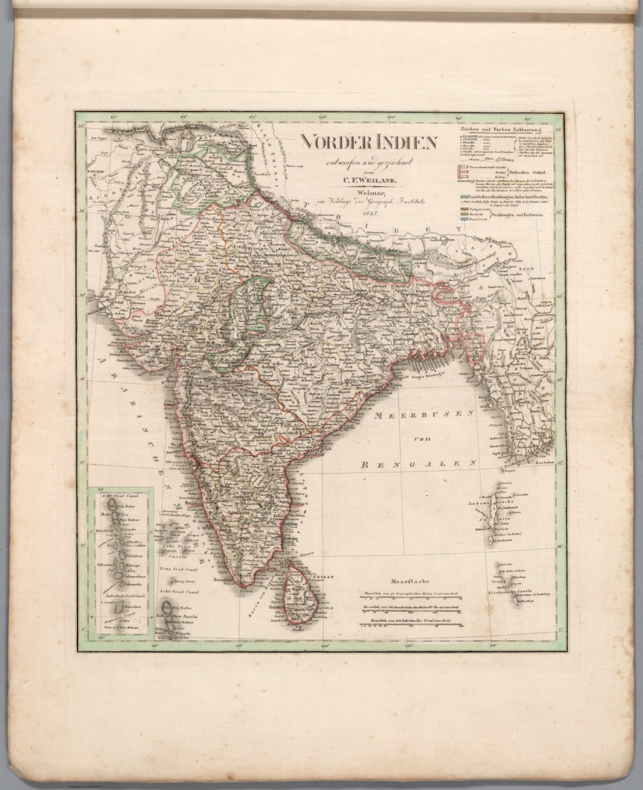
- Author
-
Weiland, C. F. (Carl Ferdinand), 1782-1847
- Subjects
- India
- Abstract
Map of India, as of 1827. Shows political boundaries, cities, railways, canals, population, topography, bodies of water, drainage, coastlines and islands. Relief shown with hachures. Includes latitudinal and longitudinal lines, as well as a legend and three bar scales. With inset map: Acht Grad Canal. Hand-colored engraving. Map is 37 x 34 cm, on sheet 57 x 45 cm. (Plate number taken from table of contents.), Hand-Atlas über alle Theile der Erde zunächst für Bürgerschulen und Zeitungsleser bestimmt by Carl Ferdinand Weiland; published in Weimar, 1829. (Date inferred based upon date of latest map within atlas.) Title translates to: General hand-atlas for all parts of the world, initially intended for public schools and newspaper readers. Bound in blue paper covers. which are blank. Collation: 2° : [2], I-XII, XIV-XIX, XXI-XXII, XX, XXIII-LX leaves of plates. This copy missing map number XIII, entitled “Preussische Monarchie”. Atlas comprised of title page and table of contents, followed by fifty-nine maps with global coverage, including two world maps (divided into Western, Eastern, Northern and Southern Hemispheres), Europe, the Middle East, Asia, Africa, North America, South America, Australia and the West Indies. Maps show political boundaries (including European colonies), cities, forts, population, railways, canals, population, topography, deserts, bodies of water, drainage, coastlines, islands and water routes. Map of North America displays territories of certain indigenous peoples. Hand-colored copper engravings with hand-drawn annotations on some maps.
- Published
- 1827
36. India : (South part) [North part]. / by Edwd. Weller F. R. G. S. ; engraved by Edwd. Weller, Duke Street Bloomsbury.
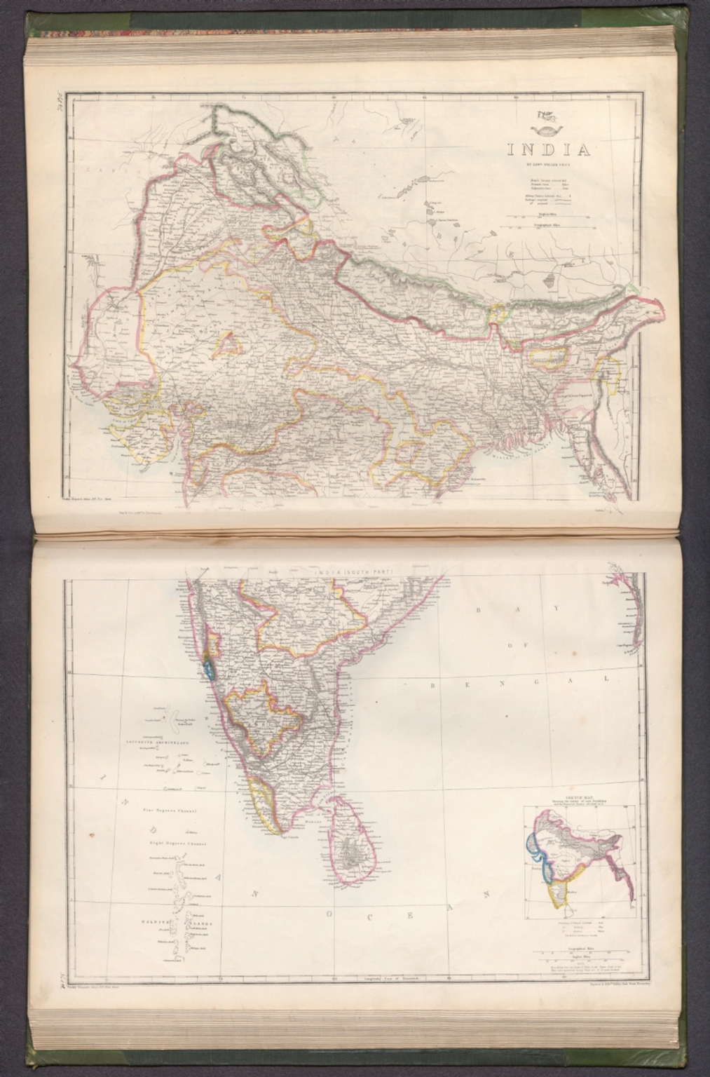
- Author
-
Weekly Dispatch and Weller, Edward, 1819-1884
- Subjects
Military - Abstract
Map of India (south and north parts). Shows political boundaries (delineating British territories and independent states), cities, military stations, railways, topography, bodies of water, drainage, coastlines and islands. Relief shown with hachures. Includes latitudinal and longitudinal lines, as well as a legend and bar scales given in English and geographical miles. With inset map: Sketch map, showing the extent of each Presidency and the Protected States attached to it. Hand-colored lithograph. Map is 60 x 42 cm, on two sheets, together 69 x 48 cm. Sheets presented in sequence. Appears in Vol. II : Foreign., The dispatch atlas, in two volumes: Vol. I : British and .Vol. II : Foreign. Published by the Weekly Dispatch, London, 1863. Includes a preface, directions for binding and a table of contents for both volumes, which lists the maps in order of appearance, with plate numbers handwritten beside map titles. Preface begins: The subscribers to the Weekly Dispatch have in this collection the most full and accurate survey of the world's surface that has yet been presented to the public in any single series. Both volumes bound in board covered in dark green linen, with spine and corners in calf. Gilded spine titles, as well as ornamentation on spines and front and back covers. With marbled end papers and gilded page edges. Collation: Volume I: [6] pages, 129 leaves of plates (some double); Volume II: 147 leaves of plates (some double). The work’s total 276 plates contain 300 maps. Each plate number handwritten in ink above map. First volume focuses on the British Isles, especially England. Second volume covers the larger globe, featuring Europe, the Middle East, Asia, Africa, North America, Central America, South America, Australia, New Zealand, the Pacific Ocean and the Arctic. Maps show political boundaries, cities, fortresses, railways, roads, bridges, canals, ocean routes, topography, glaciers, bodies of water, drainage, coastlines, shoals, islands and water depths. Maps of the Americas include territories of indigenous peoples. Maps of the United States south delineate between Federal, Border and Confederate States. Some maps feature English translations of terms from other languages that describe geographic features, including the “Explanation of Arabic words" - such as nahr for river - in the Map of Syria. Maps created by Edward Weller, J. W. Lowry, B. R. Davies, John Dower and T. Ettling; printed by Edward Weller and Day & Son, Lithographers to The Queen.
- Published
- 1863
37. India / drawn & engraved by Edwd. Weller, Duke Street Bloomsbury.
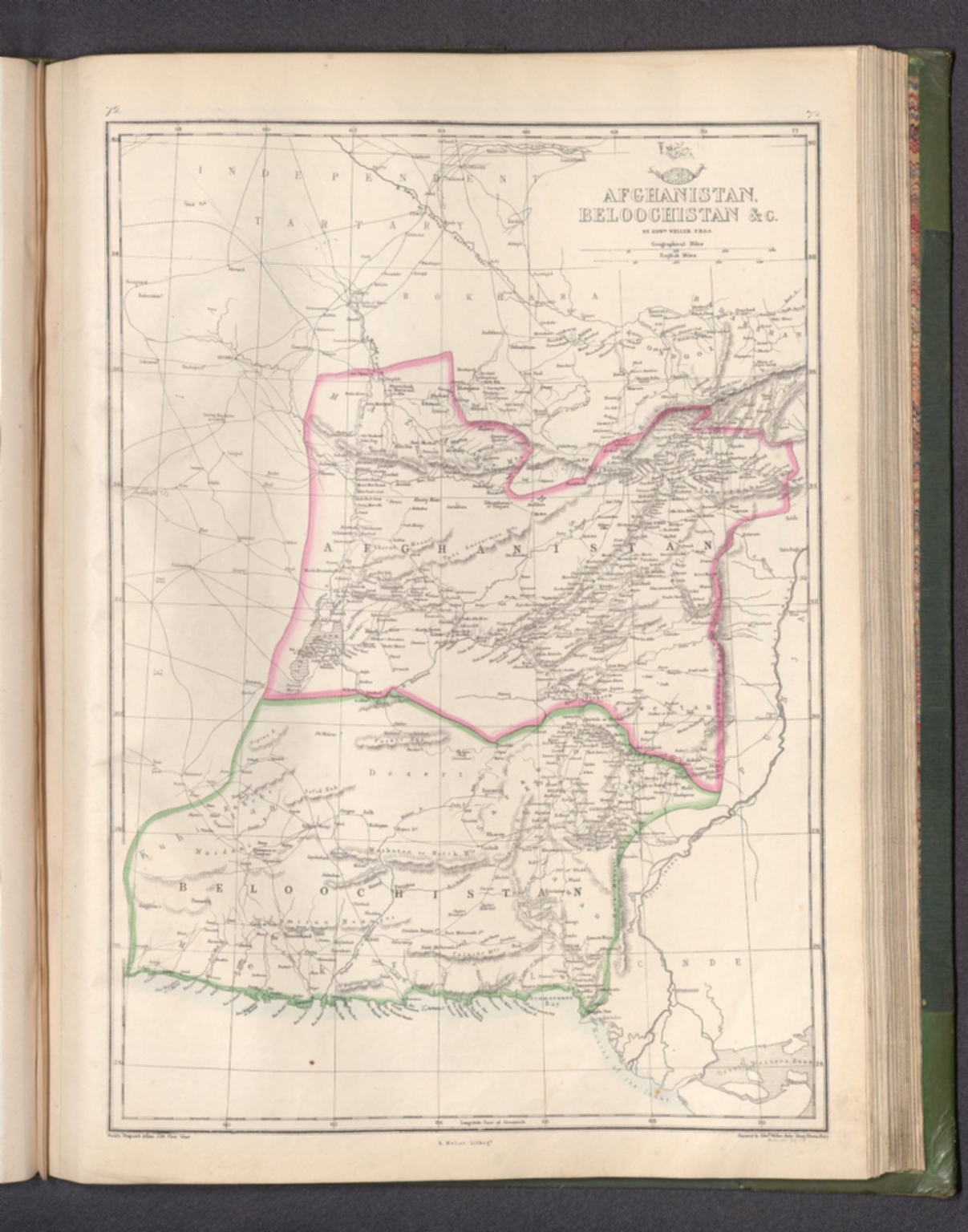
- Author
-
Weekly Dispatch and Weller, Edward, 1819-1884
- Subjects
- India
- Abstract
Map of India. Shows political boundaries (delineating British territories and independent states), cities, railways, topography, bodies of water, drainage, coastlines and islands. Relief shown with hachures. Includes latitudinal and longitudinal lines, as well as two bar scales given in geographical and British miles. Hand-colored lithograph. Map is 42 x 32 cm, on sheet 48 x 33 cm. Plate number handwritten in ink at upper right corner of sheet. Appears in Vol. II : Foreign., The dispatch atlas, in two volumes: Vol. I : British and .Vol. II : Foreign. Published by the Weekly Dispatch, London, 1863. Includes a preface, directions for binding and a table of contents for both volumes, which lists the maps in order of appearance, with plate numbers handwritten beside map titles. Preface begins: The subscribers to the Weekly Dispatch have in this collection the most full and accurate survey of the world's surface that has yet been presented to the public in any single series. Both volumes bound in board covered in dark green linen, with spine and corners in calf. Gilded spine titles, as well as ornamentation on spines and front and back covers. With marbled end papers and gilded page edges. Collation: Volume I: [6] pages, 129 leaves of plates (some double); Volume II: 147 leaves of plates (some double). The work’s total 276 plates contain 300 maps. Each plate number handwritten in ink above map. First volume focuses on the British Isles, especially England. Second volume covers the larger globe, featuring Europe, the Middle East, Asia, Africa, North America, Central America, South America, Australia, New Zealand, the Pacific Ocean and the Arctic. Maps show political boundaries, cities, fortresses, railways, roads, bridges, canals, ocean routes, topography, glaciers, bodies of water, drainage, coastlines, shoals, islands and water depths. Maps of the Americas include territories of indigenous peoples. Maps of the United States south delineate between Federal, Border and Confederate States. Some maps feature English translations of terms from other languages that describe geographic features, including the “Explanation of Arabic words" - such as nahr for river - in the Map of Syria. Maps created by Edward Weller, J. W. Lowry, B. R. Davies, John Dower and T. Ettling; printed by Edward Weller and Day & Son, Lithographers to The Queen.
- Published
- 1863
38. 7. General Karte von Vorderindien zur Übersicht der Hauptverhältnisse den Manen James'Rennell dargebrach

- Author
-
Berghaus, Heinrich, 1797-1884
- Subjects
- India
- Abstract
Digital copy only courtesy of Barry Ruderman maps., Here we show 11 of the originally published 15 maps of the Atlas von Asien - 9 original paper copies and 2 digital copies. Of the original 18 maps announced (number 19 should be 18) only 15 were ever published and these three were never completed: No. 1 - Generalkarte von Asia, No. 3 - Das Westliche Hochasia, No. 4 - Die Halbinsel von Kleinasia [Turkey]. While financially the atlas was a failure, the cartography was outstanding and made Justus Perthes world famous instantly. These are the largest and best German maps of that era and area - published by Justus Perthes in Gotha. From my dealer Martin N. -"I was in Gotha in the Perthes archive some years ago and they told me that the Atlas Asia was - in its time - a business disaster: much too expensive to get a broader audience, the publication of the maps - not all planed maps were finally published - took more than 25 years. To make a long story short: Based on the archive documentation only around 20 sets were bound and sold by Perthes publishing. The rest of the edition - between 200 and 550 depending on the map - were sold individually and only a handful of these sets are found in a complete bound form today." "We can begin by looking at the famed German cartographer Heinrich Berghaus’s Atlas von Asia (1832–1837), published by Justus Perthes in Gotha and residing in the Perthes Collection. Best known for his Physikalischer Atlas (1838–1848) and work with Alexander von Humboldt, Berghaus was trained as a surveyor yet never left Europe. Atlas von Asia contains ten land maps and seven nautical charts derived from British, Dutch, and Portuguese colonial administration, scientific expeditions, and diplomatic missions. While Berghaus’s maps originated between the early 1830s and the 1850s, some of their geographic and hydrographic information was collected over a century earlier, when Jesuit missionaries worked in close collaboration with Qing court surveyors to map the empire (Cams 2017). This was the Asia that was reachable and navigable by the intrepid European—accompanied by local guides and beasts of burden—on foot, by horse, or aboard ships. In this sense, Asia was defined not by geographic markers, but the limits of body and technology. If we are to consider the logistics of the atlas, an even more interesting picture emerges. Rather than being sold as a single volume, Berghaus’s maps of Asia could be purchased individually through a subscription service, allowing European consumers to literally assemble an image of Asia that aligned with their interests and income. One could conceptualize an itinerary from the comfort of home. From the Levant and the Arabian Peninsula, over the Ural Mountains and down to the South Pacific, each map is a visually remarkable object: they combine alphanumeric notation, hatching and stippling, color wash, and textual narrative to convey decades’ worth of information. Die Chinesische Küste der Provinz Kuang-tung, zu beiden Seiten des Meridians von Macao (1834), for example, depicts the southern coastal region and its adjacent islands in the South China Sea in chorographic and coastal view. In a lengthy explanatory note running down the center of this rare map, Berghaus gives an overview of the oceanic and meteorological conditions of the region and cites the work hydrographers and surveyors of the East India Company as well as the results of the McCartney Mission (1793), the first British diplomatic endeavor to China, which occurred nearly four decades earlier. Berghaus’s Asia transcended continental divides, delimited instead by the legacy of mercantile capitalism and imperial ambition. Berghaus’s Asia was also an intellectual project. Viewed together, his disparate maps of territories east of Europe form a cartographic palimpsest that reveal a lineage of Orientalist scholars and their relation to the imperialist imaginary. His map of China and Japan (1843), published as the second sheet in the map sequence, is a product of nineteenth-century philological interest and inquiry. In addition to referencing the work of Jesuit missionaries and the cartographer Jean-Baptiste d’Anville (1697–1782), Berghaus consulted maps created by the prominent German philologist and Orientalist Julius Klaproth (1783–1835), who travelled through the Caucuses and gained expertise in the region’s various tongues. Klaproth was also a cartographer and included a map of the over forty languages spoken in East and Central Asia in his 1823 volume Asia polyglotta. His representations of East Asia, on the other hand, were created not from direct observation, but were a compilation of sources that he was able to decipher in European, Central Asian, and East Asian languages. These included indigenous maps, surveys, and dictionaries. Berghaus in turn adapted this work; his map of China and Japan includes a chart of geographic terms in nine languages, including Turkish, Tibetan, and Ainu, offering a glimpse into the linguistic and cultural richness of the region." Mimi Chung, 2021 - see pub reference field). From an 1885 review and history the atlas: "In 1832 he distributed the announcement and invitation to subscribe for the following work: GROSSER ATLAS o the non-European parts of the earth In large eagle format. First department: ASIA Submitted and His Majesty, Frederick William III, Kings of Prussia granted with your highest permission dr HENRY BERGHAUS. Asia« first, 19 sheets in two sections: A. Maps, B. Sea charts, in the Koloffal size of 90 X 60 cm on average. and the publication was justified by the fact that "in German mapmaking, too little consideration has been given to the geography of the continents outside of Europe". On December 15, 1832, the first delivery, consisting of 3 cards with extensive text, was issued; it was followed by one more over the next four years, until the fifth and last was issued in 1837. Although 15 sheets had been published, one had to pause, the undertaking had already swallowed up enormous amounts for that time, and the further one advanced with it, the more one realized that a continuation 1816-1853 not to allow free. But if the outer side wasn't satisfactory either, it was definitely the inner side. If the direct benefit was nil, or even worse than that, the company must have felt this disfavour for years - the indirect benefit was immeasurable! The Atlas of Asia made Juftus Perthes a global company in one fell swoop. Certainly the Stieler's atlas had found great recognition, found wide distribution abroad, which itself was busy with similar publications, but it had hardly found its way, for which it already lacked sufficient elegance and pretentious appearance. Berghaus' Asia, however, was able to meet the most excellent foreign geographical publications in terms of its outward appearance. In the light of its scientific content, it was far above those, it surpassed everything that had been done before. In particular, the memoranda prepared for most of the maps testified to the immense diligence and diligent work of the author, they gave an account of the then state of geographical knowledge of the countries shown in a way that is only possible with such a precise connection of map and text can happen, some of the same highly valuable literature references still form today, e.g. B. the Memoir of the Map of Affam, which contains no less than 182 pages in 4°. It would hardly have been possible for Wilhelm Perthes to bring this costly undertaking to publication if he had not received the means to do so on the other hand through considerable results from his other publishing house, this was the case through - Stieler's school Atlas." Further notes from Perthes Catalog "dr Henry Berghaus' Atlas of Asia. XVIII leaves in large eagle format, with detailed text in large 4to. A. Maps: CONTENTS B. Seekarten: 1. General Map of Asia. 2. Chinese Empire and Japan. Bangka-Strasse. 11. Sumatra Island, Laccadives, Maldives, Singapore Island, 8. Western High Asia. 4. The Peninsula of Asia Minor. 12. The Persian Gulf. 18. The Philippines and the Salu Archipelago. 14. The China Sea. Southern leaf. 5. Syria. 6. Arabia and the Nile. 7. Near India. 8. Indo-India. 15. The China Sea. Northern Leaf. 16. The Chinese coast on both sides of Macao. 17. The Sands or Borneo Sea, also as a map of Djava, 9. Assam mit Bhotan, Djinthia, Katschbar, Munipur. 10, Theil des Himalaya in Kumaon, Gurhwal, Sirmar eto 18. (19) The Ural Mountains. Teselskning No. 19. is an engraving error, the Lesser Sunda Islands, Celebes, etc. 18. (see after No. 10). The cards (Nos. 1, 3, 4 did not appear) were also handed in individually, each at Thlr. with text depending on the strength of the same su different price. The memorandum for No. 5 is missing." In original German: "Dr. Heinr. Berghaus' Atlas von Asia. XVIII Blätter in gross Adlerformat, mit ausführlichem Text in gross 4to. A. Landkarten: INHALT B. Seekarten: 1. Generalkarte von Asia. 2. Chinesisches Reich und Japan. Bangka-Strasse. 11. Insel Sumatra, die Laccadiven, Malediven, Insel Singapore, 8. Das westliche Hochasia. 4. Die Halbinsel von Kleinasia. 12. Der Persische Meerbusen. 18. Die Philippinen und der Salu-Archipelagus. 14. Das Chinesische Meer. Südliches Blatt. 5. Syrien. 6. Arabia und das Nilland. 7. Vorderindien. 8. Hinterindien. 15. Das Chinesische Meer. Nördliches Blatt. 16. Die Chinesische Küste zu beiden Seiten von Macao. 17. Das Sands- oder Borneo-Meer, zugleich als Karte von Djava, 9. Assam mit Bhotan, Djinthia, Katschbar, Munipur. 10, Theil des Himalaya in Kumaon, Gurhwal, Sirmar eto 18. (19) Das Ural-Gebirge. Teselskning Nr. 19. ist ein Stichfehler, den kleinen Sunda-Inseln, Celebes etc. 18. (s. nach Nr. 10). Die Karten (Nr. 1. 3. 4. sind nicht erschienen) wurden auch einzeln abgegeben, jede zu Thlr. mit Text je nach Stärke desselben su verschiedenem Preis. Die Denkschrift zu Nr. 5 fehlt.", Mimi Cheng, "Cartographic Orientalism," in Mapping Africa and Asia, 08/09/2021, https://karafas.hypotheses.org/350., For the full text of Berghaus's descriptions of many of the maps in this atlas see https://books.google.com/books?id=_-sDAAAAQAAJ&dq=asia%20sammlung%20von%20denkschriften&hl=de&pg=PP7#v=onepage&q=asia%20sammlung%20von%20denkschriften&f=false
- Published
- 1836
39. (Outline map of Southern Asia) .جغرافیای عمومی اطلسی = Atlas of general geography. Istanbul 1300 (1923).
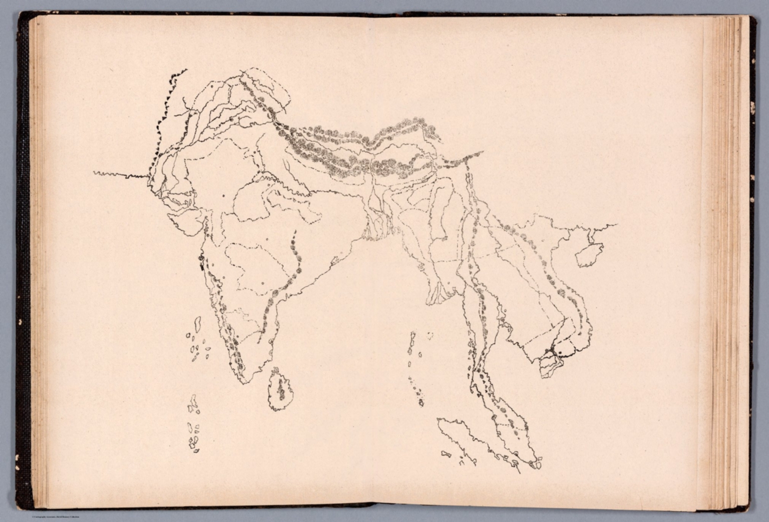
- Author
-
Hossein
- Subjects
School - Abstract
Outline map India and part of Southern Asia., Atlas of General Geography in Ottoman Turkish, The work of Hussein : Rushdieh Schools of Geography, military service. Published in Istanbul 1300 (1923). Includes 26 manuscript outline maps of the world regions and countries. Published without title for student’s practice. Titles provided by cataloger. Maps illustrating physical and geographic features of land. The work of Hussein : Rushdieh Schools of Geography, military service. Published in Istanbul 1300 (1923). Some maps showing political and administrative boundaries in color, mountains, rivers and forests. Relief Shown by hachures. Some maps bound upside down. The collection is bound in embossed black paper covers with “اطلاس = Atlas” on spine in gilt.
- Published
- 1923
40. India, Burma & Ceylon. Designer: B. S., B. A.
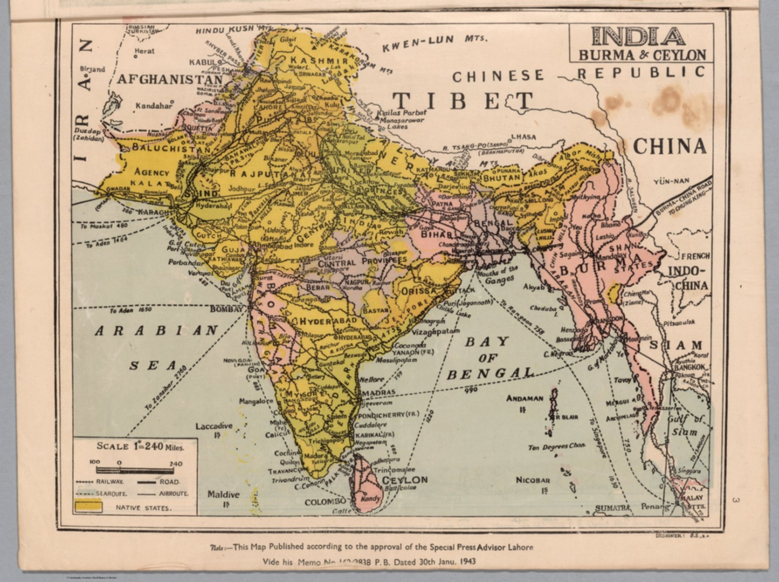
- Author
-
Map House & Indian Book Depot, Kaushal, B. S. (Biba Singh), and Vir Milap Press
- Subjects
Pictorial map - Abstract
Colored map of India, Burma [Myanmar] and Ceylon [Sri Lanka]. Shows political boundaries, major cities, railroads, roads, lakes, drainage and coastlines, as well as air routes and ocean routes with distances between ports. Features the delineation of "Native states". Includes a legend, bar scale and scale statement: 1" = 240 miles. "Note: This map published according to the approval of the Special Press Advisor Lahore Vide his Memo No 162/2838 P. B. Dated 30th Janu. 1943." Map is 24 x 30 cm, on sheet 27 x 36 cm., Atlas of India, published by the Map House & Indian Book Depot in Lahore, 1943. Staple-bound in tan-colored paper with title and imprint in red lettering on front cover. Includes a table of contents. Contains fifteen maps (fourteen in color) of different regions in India, as well as current-day Pakistan, Myanmar and Sri Lanka. Maps show political boundaries, major cities, railroads, roads, lakes, drainage and coastlines, as well as air routes and bay and ocean routes with distances between ports. Many maps have insets showing the elevation of the main maps, with color coding. Maps also accompanied by pictorial views of significant sites. (Date based upon map dates within.)
- Published
- 1943
41. Map of the Northern Part of the Punjab and of Kashmir, also of the frontiers of Ladak and Little Tibet: compiled from the Surveys of G.T. Vigne, Esq., Captain C. Wade, Lieuts. J. Anderson and H.M. Durand ... by J. Walker. Engraved by J. & C. Walker. Published by John Walker, Geographer to the East India Company, March 30th. 1846.

- Author
-
Walker, John, Vigne, G. T., Snderson, J., Wade, C., and Durand, H. M.
- Subjects
- India, Punjab, Kashmir (India)
- Abstract
Engraved outline color map on sheet 98x68, with inset: and in the lower part covers Punjab, with inset map "., Engraved outline color map on sheet 98x68, dissected and folded into red embossed covers with title "Kashmir Punjab &C." in gold on front cover. Map centered on the Vale of Kashmir, divided by colored lines into Himalayan uplands of Kashmir and Ladak and in the lower part covers Punjab, with inset map "Sketch map of countries north of Iskardo and Ladak". Map labels roads, trails, mountain passes, cities, villages forts and mountain ranges. Includes annotations from explorers on the nature of the terrain, vegetation, geology and sources of great rivers. Relief shown by hachures. Notes on the map from Alex Johnson: "An exceedingly rare, large format map published by for the private use of the East India Company directors and senior civil and military officials depicting Northern Punjab, Jammu & Kashmir as well as great arch of the Western Himalayas, predicated upon the very best available sources, created just as the British were gaining victory during the First Anglo-Sikh War; the map was a vital tool in Britain’s successful quest to gain mastery over North-western India; the present example owned by Johann Detleff Prochnow, a prominent missionary and explorer operating the Himalayas. Copper engraving with original outline hand colour, dissected into 30 sections and mounted upon original linen, folding into original red cloth covers with Greek Key blindstamped borders and gilt-debossed title, manuscript owner’s inscription of “J.D. Prochnow” [Johann Detleff Prochnow] in ink to front endpaper (Excellent condition, map clean and crisp, just some very slight marginal wear to covers), 98 x 67.5 cm (38.5 x 67.5 inches). This important and impressive map was issued on the orders of the directors of the East India Company (EIC) for high-level official use in the immediate wake of the First Anglo-Sikh War (1845-6). During this conflict, which occurred within the context of the ‘Great Game’ (Britain’s cold war with Russia over control of the heart of Asia), Britain and the once mighty Sikh Empire, which controlled the Punjab and the Kashmir, came to blows. Britain ended up defeating the Sikhs and gaining control of Kashmir and the Bist Doab, the prosperous area southeast of the Sikh capital, the great city of Lahore. From that point onwards, Britain would continue to apply further pressure on the Sikh Empire, until finally vanquishing it and annexing its lands during the Second Anglo-Sikh War (1848-9). The map was issued by the EIC’s official geographer John Walker in London to not only show the theatre of the First Anglo-Sikh War but to give senior officials an idea of the territories they hoped to conqueror or otherwise control in the near future (the map was printed on March 30, 1846, before news of the end of the war had reached London, but after initial British victories made Whitehall reasonably confident of victory). While the map is composite work, with a very diverse quality of geographic coverage, it importantly brings together the very best available sources on the mapping of the Northern Punjab, Kashmir and as the adjacent Himalayan region together in a single map for the first time, including new intelligence fresh from the battle theatre. The great rarity of the map – the present offering seems to be 1 of only 2 known examples – is due the fact that it was a private issue reserved for the use of high-level officials (i.e. British politicians, EIC Directors and military officers); there is no evidence that it was offered for sale on the public market. Walker would have executed only a very small print run, and the survival rate of such large maps is very low. The present example of the map belonged to Johann Detelff Prochnow, one of the most important Protestant missionaries in India through the 1840s and ‘50s, as well as an explorer of the Western Himalayas, who resided in in Kothgar, near Shimla. He was likely able to obtain an example of the map from one of his many contacts in the EIC hierarchy. The map is divided into Punjab (generally fertile lowlands) and the Himalayan uplands (Kashmir, Ladakh, Gilgit, etc.) by coloured lines that run across the scene about a third of the way up from the bottom (pink borders Punjab, while green borders the Himalayan zone). The map embraces a considerable amount of territory, extending from just below 31°N to just below 38°N latitude, and from 72°E to 79°E longitude. Roughly centred on the Vale of Kashmir, it embraces the Punjab down as far as Ferozepur and Ludhiana, and extends as far north as the Pamirs in what is today Tajikistan; the map ranges, in the west from Attock (the northernmost tip of Punjab) as far east as part of what it today Himachal Pradesh, with the key hill station of Shimla (the future ‘summer capital’ the British Raj), being located in the lower right corner. The map is a composite of the best available sources, created before any part of the region was subject to systematic trigonometric surveys. It shows that some areas were reasonably well known to the British, while others were still complete enigmas; consequently, some parts of the map are impressively accurate, while other places are products of conjecture, or event left blank. The map labels innumerable roads, trails, mountain passes, cities, villages and forts, while some mountain ranges are expressed through hachures, while others are faint conjectural lines. The map features many fascinating annotations from explores on the nature of the terrain, its vegetation, geology and the mysterious sources of great rivers. The depiction of the Vale of Kashmir is quite well formed, while the depiction of the Himalayan areas beyond is less precise, based on fragmentary intelligence collected during various exploring expeditions. Much of the information on the montane regions was compiled by Godfrey Vigne (1801-63), an extraordinary Early Victorian figure. Educated at Harrow, before training as a lawyer at Lincoln’s Inn, he gained fame as a professional cricket player. However, bored with aristocratic life in England, in 1831 he travelled to Persia and then India. From 1835 to 1838, he extensively explored Kashmir and Ladakh, making numerous sketch maps, including of the Vale of Kashmir’s mountain passes. Vigne also made a politically consequential trip to Afghanistan. His memoirs of his time in Asia were published as Travels in Kashmir, Ladak, Iskardo, the countries adjoining the mountain-course of the Indus, and the Himalaya, north of the Panjab, 2 vols. (London, 1842), accompanied by large map, of which we will discuss later. Vigne, in turn based much of his information on the Himalayan region from the excellent maps from the expedition of William Moorcroft (1767-1825), a famed veterinarian and equestrian and who between 1819 and 1825 travelled through what it today Himachal Pradesh, Ladakh, Kashmir, Peshawar, Afghanistan and Bokhara (Uzbekistan), in search of fine Central Asian horses for the use of the East India Company. Moorcroft’s cartographer was the youthful, but exceedingly talented, George Trebeck (1800-25), who made some of the finest expedition sketch maps ever made in India or Central Asia. While both men sadly perished during the mission, their papers and maps were safely delivered to Calcutta, where then were disseminated to the right people and later, in part, published. John Arrowsmith notably created a fine overview map of Moorcroft and Trebeck’s discoveries, Himalayan provinces of Hindustan and the Panjab, in Ladakh and Kashmir; in Peshawar, Kabul, Kunduz, and Bokhara (1841). The depiction of the Punjab, the fertile lowlands below the Himalayas, is derived from several recent, high quality sources. The great river systems (Punjab means the “Land of Five Waters” referring to the rivers Jhelum, Chenab, Ravi, Sutlej and Beas) is, in good part, derived from Captain Claude Wade’s map Indus and Punjab Rivers (1833). Wade was a diplomat and explorer, who maintained stellar relations with the Sikh court of Ranjt Singh, which allowed him the opportunity to map much of the Punjab. The coverage of the Punjab’s main transport corridors, densely packed with cities and villages connected by roads, running diagonally from the southeast to the northwest, from ‘Lodeana’ (Ludhiana) through Lahore to ‘Kuller Kahar’ (Kallar Kahar), is largely derived from the itinerary surveys conducted by Lieutenants John Anderson (1810-57) and Henry Durand (1812-71), the official cartographers of the Army of the Indus, the massive British force that traversed the Punjab on their way to invade Afghanistan in 1838-9. However, as will be discussed later, the coverage of the area features many important new details mapped by British officials and soldiers in the years since. The cartographic inset in the upper left corner of the composition showcases the vast region extending from Skardu (today in Pakistani Kashmir) up and over the Karakorum Range as far as Kashgar (today in Xinjiang, China). The Story Behind the Map’s Publication In 1841, When George Vigne returned to London from his decade of travels in India, Persia and Central Asia, he procced to write his grand memoir of his travels. Vigne, a high-society figure was personal friends with many of the EIC Directors, who were naturally eager to learn from Vigne’s experiences. It seems that the directors put Vigne in touch with John Walker (1787 - 1873), the Official Geographer to the East India Company. Walker, a partner in the firm of J. & C. Walker, was a prominent figure in the British cartography scene; he was also the official chart engraver for the Admiralty. Vigne and Walker worked together to fashion a grand map of Northern Punjab, Kashmir and the Western Himalayan region from the excellent sources described above. The EIC agreed to pay for the publication of the map, entitled Map of Kashmir with its passes; Ladak & Little Tibet, the mountain course of the Indus and the Alpine Punjab generally taken principally from the MSS. Surveys of G.T. Vigne, Esqr. F.G.S., which was issued loose within a pocket in the back of the first volume of Vigne’s 1842 memoirs. Please view a scan of the Vigne-Walker map from the collection of the American Geographical Society at the University of Wisconsin-Milwaukee: https://collections.lib.uwm.edu/digital/collection/agdm/id/14907/ Vigne and Walker’s work was a masterpiece of frontier cartography that revealed the general geographic nature of the Northern Punjab and Kashmir for the first time on a single map, as well as giving a fragmentary, yet valuable, depiction of the Western Himalayan region beyond. It was an excellent starting point for further discovery. However, by the time of the First Anglo-Sikh War, the EIC Directors urgently needed better information on the geography of the Northern Punjab; the British territories immediately to the west; as well as the territory between the Punjab and Kashmir. This information was vital for planning where to station and deploy troops; where to set up headquarters of civil administration; and where to fund infrastructure (road and bridge building) projects; and, of course, were to draw future political boundaries. The depiction of the areas that were the theatre of the First AngloSikh War, taking up roughly the southern third of the Vigne map, were now seen as inadequate for the director’s requirements. As they hoped that the war was concluding int their favour, the directors commissioned Walker to provide them with an improved map. The Vigne map was an excellent piece of cartography, and Walker still possessed the original copperplate, which remained the legal property of the EIC. As there were very few new discoveries in the region that made of the upper two thirds of the map (Kashmir and northwards), to create the new and improved map Walker decided to use the Vigne plate, but to rework its lower third. In converting the Vigne map into the present work, beyond the fact that Walker changed and moved the title from the lower-left to the upper right, the map shows revisions in the lower third of the map that are so extensive as to make the resulting work an entirely new and different map. To begin with, in what is today Himachal Pradesh and western Kashmir (below Ladakh), which are shown in only the vaguest forms on Vigne’s map, have been extensively filled in with fresh information, gained both from a more detailed study of Moorcroft and Trebeck’s maps, as well as very recent mapping conducted by the Indian Army. While much more surveying would need to occur, the present map ensures that these areas are no longer enigmas. Importantly, the present map features a wealth of new new information on the main settlement corridors of Northern Punjab; the main rivers and key roads are now showcased in great detail, along with the precise placement of hundreds of villages that were not present on Vigne’s map. This area was and would continue to be the main theatre of the Anglo-Sikh conflict, and senior administrators and army officers would have considered it mapping to be of vital importance. Notably, the present map shows that London was by this time well aware of the key British victory over the Sikhs at Ferozeshah (December 21-22, 1845), which is engraved just below the middle of the bottom neatline (near the British cantonment of Ferozepore. The map also features information on travel corridors between the Punjab and Jammu & Kashmir. Importantly, the present map would have been critically useful during the interbellum period, as well as during the Second Anglo-Sikh War whereby the EIC conquered all the Punjab, adding the final large Indian jewel to the British imperial crown. Curiously, one will notice that the map features only a partial left-hand neatline, while some incomplete portions of words are engraved entering the map in the upper left. These details were present on the original Vigne plate and remained unchanged in the publication of the present map. To be clear, the present map is complete as issued; however, for reasons unknown, it seems that Walker may have once considered making the plate into part of a map that extended further westwards but, for reasons unknown, abandoned the project. The present map would not be generally superseded until teams of the Great Trigonometrical Survey (GTS) under William Johnson completed advanced scientific systematic surveys of Northern Punjab all the way to Attock in 1854. Kashmir would be revealed in its full modern geographical form following the surveys conducted by Captain Thomas George Montgomerie between 1857 and 1860, an endeavour that is rightly considered to be one of the greatest technical feats of surveying of the 19th Century. The Provenance of the Present Map: Johann Prochnow – Missionary and Explorer in the Himalayas The present example of the map bears the manuscript owner’s inscription inside the front cover of “J.D. Prochnow”, being Reverend Dr. Johann Detleff Prochnow (1814 - 1888), one of the most prominent Protestant missionaries in the Himalayan regions of India, as well as an acclaimed explorer. After being accused by the authorities in his native Prussia of ‘anti-government activities’, Prochnow travelled to India in 1840 to join the Gossner Missionary Society. He later joined the Himalayan chapter of the leading British Protestant organisation in India, the Christian Missionary Society (CMS), eventually becoming its director. Based in in Kotghar (labelled on the present map as ‘Kotghur’ in the lower right corner), Prochnow extensively explored the Western Himalayas, on long, dangerous high-altitude treks in search of villages that might be receptive to his religious message. While many EIC officers viewed missionaries with great scepticism, Prochnow was well-liked and highly respected by the authorities in India. His close connections and ‘street cred’ as an explorer would have allowed him to obtain the present map, which was otherwise not publicly available. Prochnow would have been intensely interested in the map, as it not only showed his base region in amazing new detail, but it revealed new horizons for possible missionary activity in Kashmir and the Punjab (although these largely Muslim regions would never be particularly receptive to missionaries). Prochnow, who returned to Germany in 1858, was also a fine author who wrote valuable memoirs of his time in India as well as analysis of the Hindi language. A Note of Rarity Befitting such a large map issued in a small print run for a high-level private consumption, the present map is exceedingly rare. We can trace only a single institutional example, at the British Library. We cannot trace a sales record for another example since a listing in a 1905 Arthur Probsthain catalogue. Historical Context: The British Conquest North-western India The Directors of the East India Company commissioned the present map at a critical juncture during a transformative decade (1839-49) of British aggression and expansion in the Indian Subcontinent. By 1818, the EIC, upon vanquishing the Maratha Confederacy, controlled almost all of India (either directly or via allied ‘princely states’). The last major region of the Subcontinent not under their control was the Northwest and the far north, including Baluchistan, the Sindh, Punjab, Kashmir and Jammu. The Punjab was the heart of the Sikh Empire (1799-1849), a powerful and culturally sophisticated state ruled by Maharajah Ranjit Singh, a strong and wise leader, backed by the Khalsa, a modern Western-trained army. The Sikhs recently conquered Kashmir and were allied with the British. Since 1820, Jammu had been ruled by Raja Gulab Singh, of the Hindu Dogra Dynasty, likewise a British ally. The Sindh was ruled by the Talpur Dynasty, a Shia regime that had been in power since 1783. Baluchistan, a wild transitional area between India and Persia, was controlled by several tribal kingdoms. Through the 1820s, the EEC felt little motivation to expand their power beyond the Sutlej (the river the Punjab than marked the Anglo-Sikh boundary). Both the Sikhs and the Dogra were reliable and strong allies, while the entities beyond were too remote to be considered troublesome. Things began to change in the 1830s, due to two mutually reinforcing factors. First, the East India Company, a commercial enterprise, found the costs of the civil administration of the subcontinent to be unexpectedly burdensome. While some provinces such as Bengal were highly profitable, much of India was a financial drain on the Company’s coffers. Punjab, the ‘Breadbasket of India’ was an immensely wealthy land, anchored by the great cultural and commercial centre of Lahore. Many key figures came to believe that the British Empire in India would not be complete without the Punjab which had the ability to export food across the subcontinent, while providing millions of rupees annually to the EIC Treasury. Second, Russia was aggressively conquering parts of the Caucuses and Central Asia, and many came to believe that St. Petersburg’s ultimate goal to make a run on India. Encouraged by jingoistic writers, many officials in Calcutta and London were becoming downright paranoid, and by the early 1830s the Anglo-Russian rivalry was deemed the ‘Great Game’. However, the Russian term for the showdown, the ‘Torment of Shadows’ was perhaps more apt, as the contest was largely a ‘cold war’, fueled by overreactions to rumors, as opposed to genuine threats to India. In any event, the mere missive of any Russian action anywhere in Asia, sent British officials into a frenzy, often motivating them to pursue extreme measures totally out of proportion to the matter at hand. In this climate, the Northwest of India and, by extension, Afghanistan, was seen as the firewall protecting India from Russian aggression. Of course, it also must be recognized that some EIC officials who merely wanted Britain to conquer all of India (but privately though the Great Game to be silly), cynically wound up their ‘Russia-paranoid’ colleagues in support of their expansionist objectives. Russian interference in Afghanistan during the Persian Siege of Herat (1837-8) convinced the Great Game ‘hawks’ that Russia was poised to take over Afghanistan, and that they would be upon the gates of India in short order. This motivated the EIC to mount the breathtakingly stupid invasion of Afghanistan in the what became known as the First Anglo-Afghan War (1839-42). This venture resulted in what is often described as worst defeat in the history of the British Empire, highlighted by the fact that only a single soldier from the British garrison in Kabul made it home alive. The British failure to take Afghanistan, far from discouraging further aggression, heightened the EIC’s desire to conquer the Northwest of India, as the Sindh and the Punjab were seen as the Subcontinent’s last lines of defense. The British made short work of the Sindh, toppling the Talpur Dynasty and annexing the province in 1843. This gave them control of the mouths of the Indus and great seaport of Karachi. Meanwhile, the state of play had radically changed in the Sikh Empire. The death of Ranjit Singh created a power vacuum, as the country was ruled by rapid succession of incompetent, weak, debauched and eventually adolescent leaders. The powerful Khalsa army became listless, as the once formidable British ally became a rogue state that was a danger to itself and a liability to Britain (especially if the Russians ever appeared at the Khyber Pass). This played into the hands of the expansionists in the EIC hierarchy who coveted the green fields and wealthy merchant towns of the Punjab. Indeed, many British officials and military commanders had been given a chance to view this valuable country first-hand as their troops were stationed there during the late Afghan War. The exact causes of the what became known as the First Anglo-Sikh War (December 11, 1845 – March 9, 1846) are still a matter of debate. It seems that the British instigated the conflict and even bribed several Sikh commanders to sabotage their own cause before and during the conflict. In any event, on December 11, 1845 the Khalsa, having been provoked by the EIC, invaded British territory, crossing the Sutlej River and attacking that key British cantonment of Ferozepore. The British initially had great difficulty containing the situation, and the Sikh army made its way some miles into British territory until the two sides met at the Battle of Ferozeshah (December 21-22, 1845). Here the British won a victory that halted the Sikh invasion, even though the messy and chaotic performance of the British forces led many to question its ‘match fitness’. The British went on to invade the Sikh Punjab, winning the Battle of Aliwal (January 28, 1846) and the decisive Battle of Sobraon (February 10,1846), during which the main Sikh Army was crushed. The British then marched into Lahore, where they demanded a hard bargain. At the Treaty of Lahore (March 9, 1846), the British demanded that the Sikhs surrender the Bist Doab (labelled on the present map as the ‘Doab of Baree’), a precious strip of territory between the Sutlej and Beas Rivers. They also required that the Sikhs pay Britain an indemnity of 15 million gold rupees, a sum so high as be unpayable. In lieu of clearing the debt, the British compelled the Sikhs to surrender Kashmir. This left the British with a geostrategic chokehold on the ailing Sikh state, as they now controlled the territory leading to the gates of Lahore, as well as the Himalayan highlands above the Punjabi plains. At the Treaty of Amritsar (March 16, 1846), the British sold Kashmir to Gulab Singh, the ruler of Jammu, for 7.5 million rupees. This refilled the EIC’s sorely depleted treasury and transferred the expensive future responsibilities of governing a vast Himalayan territory to a diehard British ally. The British spent the next two years meddling in the affairs of the ailing Sikh Empire, which provoked the Second Anglo-Sikh War (April 18, 1848 – March 30, 1849). During that conflict the British utterly vanquished the Sikhs, dissolving their empire and annexing the Punjab to British India. While some peripheral areas of the subcontinent were still to be conquered, Britain had now completed the task of controlling all of India, an achievement that had eluded all the other historical empires that had attempted the same. References: British Library: Cartographic Items Maps 57540.(7.); Probsthain’s Oriental Catalogue, no. VII (London, 1905), no. 322 (p. 13); F. S. Aijazuddin, Rare maps of Pakistan (2000), p. xiv. Cf. R.H. Phillimore, Historical Records of the Survey of India, vol. IV (Dehra Dun, 1958), pp. 219, 240, 246, 282, 290, 292, 360, 389, 417, 446.
- Published
- 1846
42. (Covers to) Map of the Northern Part of the Punjab and of Kashmir, also of the frontiers of Ladak and Little Tibet: compiled from the Surveys of G.T. Vigne, Esq., Captain C. Wade, Lieuts. J. Anderson and H.M. Durand ... by J. Walker. Engraved by J. & C. Walker. Published by John Walker, Geographer to the East India Company, March 30th. 1846.

- Author
-
Walker, John, Vigne, G. T., Snderson, J., Wade, C., and Durand, H. M.
- Subjects
- India
- Abstract
Engraved outline color map on sheet 98x68, dissected and folded into red embossed covers with title "Kashmir Punjab &C." in gold on front cover., Engraved outline color map on sheet 98x68, dissected and folded into red embossed covers with title "Kashmir Punjab &C." in gold on front cover. Map centered on the Vale of Kashmir, divided by colored lines into Himalayan uplands of Kashmir and Ladak and in the lower part covers Punjab, with inset map "Sketch map of countries north of Iskardo and Ladak". Map labels roads, trails, mountain passes, cities, villages forts and mountain ranges. Includes annotations from explorers on the nature of the terrain, vegetation, geology and sources of great rivers. Relief shown by hachures. Notes on the map from Alex Johnson: "An exceedingly rare, large format map published by for the private use of the East India Company directors and senior civil and military officials depicting Northern Punjab, Jammu & Kashmir as well as great arch of the Western Himalayas, predicated upon the very best available sources, created just as the British were gaining victory during the First Anglo-Sikh War; the map was a vital tool in Britain’s successful quest to gain mastery over North-western India; the present example owned by Johann Detleff Prochnow, a prominent missionary and explorer operating the Himalayas. Copper engraving with original outline hand colour, dissected into 30 sections and mounted upon original linen, folding into original red cloth covers with Greek Key blindstamped borders and gilt-debossed title, manuscript owner’s inscription of “J.D. Prochnow” [Johann Detleff Prochnow] in ink to front endpaper (Excellent condition, map clean and crisp, just some very slight marginal wear to covers), 98 x 67.5 cm (38.5 x 67.5 inches). This important and impressive map was issued on the orders of the directors of the East India Company (EIC) for high-level official use in the immediate wake of the First Anglo-Sikh War (1845-6). During this conflict, which occurred within the context of the ‘Great Game’ (Britain’s cold war with Russia over control of the heart of Asia), Britain and the once mighty Sikh Empire, which controlled the Punjab and the Kashmir, came to blows. Britain ended up defeating the Sikhs and gaining control of Kashmir and the Bist Doab, the prosperous area southeast of the Sikh capital, the great city of Lahore. From that point onwards, Britain would continue to apply further pressure on the Sikh Empire, until finally vanquishing it and annexing its lands during the Second Anglo-Sikh War (1848-9). The map was issued by the EIC’s official geographer John Walker in London to not only show the theatre of the First Anglo-Sikh War but to give senior officials an idea of the territories they hoped to conqueror or otherwise control in the near future (the map was printed on March 30, 1846, before news of the end of the war had reached London, but after initial British victories made Whitehall reasonably confident of victory). While the map is composite work, with a very diverse quality of geographic coverage, it importantly brings together the very best available sources on the mapping of the Northern Punjab, Kashmir and as the adjacent Himalayan region together in a single map for the first time, including new intelligence fresh from the battle theatre. The great rarity of the map – the present offering seems to be 1 of only 2 known examples – is due the fact that it was a private issue reserved for the use of high-level officials (i.e. British politicians, EIC Directors and military officers); there is no evidence that it was offered for sale on the public market. Walker would have executed only a very small print run, and the survival rate of such large maps is very low. The present example of the map belonged to Johann Detelff Prochnow, one of the most important Protestant missionaries in India through the 1840s and ‘50s, as well as an explorer of the Western Himalayas, who resided in in Kothgar, near Shimla. He was likely able to obtain an example of the map from one of his many contacts in the EIC hierarchy. The map is divided into Punjab (generally fertile lowlands) and the Himalayan uplands (Kashmir, Ladakh, Gilgit, etc.) by coloured lines that run across the scene about a third of the way up from the bottom (pink borders Punjab, while green borders the Himalayan zone). The map embraces a considerable amount of territory, extending from just below 31°N to just below 38°N latitude, and from 72°E to 79°E longitude. Roughly centred on the Vale of Kashmir, it embraces the Punjab down as far as Ferozepur and Ludhiana, and extends as far north as the Pamirs in what is today Tajikistan; the map ranges, in the west from Attock (the northernmost tip of Punjab) as far east as part of what it today Himachal Pradesh, with the key hill station of Shimla (the future ‘summer capital’ the British Raj), being located in the lower right corner. The map is a composite of the best available sources, created before any part of the region was subject to systematic trigonometric surveys. It shows that some areas were reasonably well known to the British, while others were still complete enigmas; consequently, some parts of the map are impressively accurate, while other places are products of conjecture, or event left blank. The map labels innumerable roads, trails, mountain passes, cities, villages and forts, while some mountain ranges are expressed through hachures, while others are faint conjectural lines. The map features many fascinating annotations from explores on the nature of the terrain, its vegetation, geology and the mysterious sources of great rivers. The depiction of the Vale of Kashmir is quite well formed, while the depiction of the Himalayan areas beyond is less precise, based on fragmentary intelligence collected during various exploring expeditions. Much of the information on the montane regions was compiled by Godfrey Vigne (1801-63), an extraordinary Early Victorian figure. Educated at Harrow, before training as a lawyer at Lincoln’s Inn, he gained fame as a professional cricket player. However, bored with aristocratic life in England, in 1831 he travelled to Persia and then India. From 1835 to 1838, he extensively explored Kashmir and Ladakh, making numerous sketch maps, including of the Vale of Kashmir’s mountain passes. Vigne also made a politically consequential trip to Afghanistan. His memoirs of his time in Asia were published as Travels in Kashmir, Ladak, Iskardo, the countries adjoining the mountain-course of the Indus, and the Himalaya, north of the Panjab, 2 vols. (London, 1842), accompanied by large map, of which we will discuss later. Vigne, in turn based much of his information on the Himalayan region from the excellent maps from the expedition of William Moorcroft (1767-1825), a famed veterinarian and equestrian and who between 1819 and 1825 travelled through what it today Himachal Pradesh, Ladakh, Kashmir, Peshawar, Afghanistan and Bokhara (Uzbekistan), in search of fine Central Asian horses for the use of the East India Company. Moorcroft’s cartographer was the youthful, but exceedingly talented, George Trebeck (1800-25), who made some of the finest expedition sketch maps ever made in India or Central Asia. While both men sadly perished during the mission, their papers and maps were safely delivered to Calcutta, where then were disseminated to the right people and later, in part, published. John Arrowsmith notably created a fine overview map of Moorcroft and Trebeck’s discoveries, Himalayan provinces of Hindustan and the Panjab, in Ladakh and Kashmir; in Peshawar, Kabul, Kunduz, and Bokhara (1841). The depiction of the Punjab, the fertile lowlands below the Himalayas, is derived from several recent, high quality sources. The great river systems (Punjab means the “Land of Five Waters” referring to the rivers Jhelum, Chenab, Ravi, Sutlej and Beas) is, in good part, derived from Captain Claude Wade’s map Indus and Punjab Rivers (1833). Wade was a diplomat and explorer, who maintained stellar relations with the Sikh court of Ranjt Singh, which allowed him the opportunity to map much of the Punjab. The coverage of the Punjab’s main transport corridors, densely packed with cities and villages connected by roads, running diagonally from the southeast to the northwest, from ‘Lodeana’ (Ludhiana) through Lahore to ‘Kuller Kahar’ (Kallar Kahar), is largely derived from the itinerary surveys conducted by Lieutenants John Anderson (1810-57) and Henry Durand (1812-71), the official cartographers of the Army of the Indus, the massive British force that traversed the Punjab on their way to invade Afghanistan in 1838-9. However, as will be discussed later, the coverage of the area features many important new details mapped by British officials and soldiers in the years since. The cartographic inset in the upper left corner of the composition showcases the vast region extending from Skardu (today in Pakistani Kashmir) up and over the Karakorum Range as far as Kashgar (today in Xinjiang, China). The Story Behind the Map’s Publication In 1841, When George Vigne returned to London from his decade of travels in India, Persia and Central Asia, he procced to write his grand memoir of his travels. Vigne, a high-society figure was personal friends with many of the EIC Directors, who were naturally eager to learn from Vigne’s experiences. It seems that the directors put Vigne in touch with John Walker (1787 - 1873), the Official Geographer to the East India Company. Walker, a partner in the firm of J. & C. Walker, was a prominent figure in the British cartography scene; he was also the official chart engraver for the Admiralty. Vigne and Walker worked together to fashion a grand map of Northern Punjab, Kashmir and the Western Himalayan region from the excellent sources described above. The EIC agreed to pay for the publication of the map, entitled Map of Kashmir with its passes; Ladak & Little Tibet, the mountain course of the Indus and the Alpine Punjab generally taken principally from the MSS. Surveys of G.T. Vigne, Esqr. F.G.S., which was issued loose within a pocket in the back of the first volume of Vigne’s 1842 memoirs. Please view a scan of the Vigne-Walker map from the collection of the American Geographical Society at the University of Wisconsin-Milwaukee: https://collections.lib.uwm.edu/digital/collection/agdm/id/14907/ Vigne and Walker’s work was a masterpiece of frontier cartography that revealed the general geographic nature of the Northern Punjab and Kashmir for the first time on a single map, as well as giving a fragmentary, yet valuable, depiction of the Western Himalayan region beyond. It was an excellent starting point for further discovery. However, by the time of the First Anglo-Sikh War, the EIC Directors urgently needed better information on the geography of the Northern Punjab; the British territories immediately to the west; as well as the territory between the Punjab and Kashmir. This information was vital for planning where to station and deploy troops; where to set up headquarters of civil administration; and where to fund infrastructure (road and bridge building) projects; and, of course, were to draw future political boundaries. The depiction of the areas that were the theatre of the First AngloSikh War, taking up roughly the southern third of the Vigne map, were now seen as inadequate for the director’s requirements. As they hoped that the war was concluding int their favour, the directors commissioned Walker to provide them with an improved map. The Vigne map was an excellent piece of cartography, and Walker still possessed the original copperplate, which remained the legal property of the EIC. As there were very few new discoveries in the region that made of the upper two thirds of the map (Kashmir and northwards), to create the new and improved map Walker decided to use the Vigne plate, but to rework its lower third. In converting the Vigne map into the present work, beyond the fact that Walker changed and moved the title from the lower-left to the upper right, the map shows revisions in the lower third of the map that are so extensive as to make the resulting work an entirely new and different map. To begin with, in what is today Himachal Pradesh and western Kashmir (below Ladakh), which are shown in only the vaguest forms on Vigne’s map, have been extensively filled in with fresh information, gained both from a more detailed study of Moorcroft and Trebeck’s maps, as well as very recent mapping conducted by the Indian Army. While much more surveying would need to occur, the present map ensures that these areas are no longer enigmas. Importantly, the present map features a wealth of new new information on the main settlement corridors of Northern Punjab; the main rivers and key roads are now showcased in great detail, along with the precise placement of hundreds of villages that were not present on Vigne’s map. This area was and would continue to be the main theatre of the Anglo-Sikh conflict, and senior administrators and army officers would have considered it mapping to be of vital importance. Notably, the present map shows that London was by this time well aware of the key British victory over the Sikhs at Ferozeshah (December 21-22, 1845), which is engraved just below the middle of the bottom neatline (near the British cantonment of Ferozepore. The map also features information on travel corridors between the Punjab and Jammu & Kashmir. Importantly, the present map would have been critically useful during the interbellum period, as well as during the Second Anglo-Sikh War whereby the EIC conquered all the Punjab, adding the final large Indian jewel to the British imperial crown. Curiously, one will notice that the map features only a partial left-hand neatline, while some incomplete portions of words are engraved entering the map in the upper left. These details were present on the original Vigne plate and remained unchanged in the publication of the present map. To be clear, the present map is complete as issued; however, for reasons unknown, it seems that Walker may have once considered making the plate into part of a map that extended further westwards but, for reasons unknown, abandoned the project. The present map would not be generally superseded until teams of the Great Trigonometrical Survey (GTS) under William Johnson completed advanced scientific systematic surveys of Northern Punjab all the way to Attock in 1854. Kashmir would be revealed in its full modern geographical form following the surveys conducted by Captain Thomas George Montgomerie between 1857 and 1860, an endeavour that is rightly considered to be one of the greatest technical feats of surveying of the 19th Century. The Provenance of the Present Map: Johann Prochnow – Missionary and Explorer in the Himalayas The present example of the map bears the manuscript owner’s inscription inside the front cover of “J.D. Prochnow”, being Reverend Dr. Johann Detleff Prochnow (1814 - 1888), one of the most prominent Protestant missionaries in the Himalayan regions of India, as well as an acclaimed explorer. After being accused by the authorities in his native Prussia of ‘anti-government activities’, Prochnow travelled to India in 1840 to join the Gossner Missionary Society. He later joined the Himalayan chapter of the leading British Protestant organisation in India, the Christian Missionary Society (CMS), eventually becoming its director. Based in in Kotghar (labelled on the present map as ‘Kotghur’ in the lower right corner), Prochnow extensively explored the Western Himalayas, on long, dangerous high-altitude treks in search of villages that might be receptive to his religious message. While many EIC officers viewed missionaries with great scepticism, Prochnow was well-liked and highly respected by the authorities in India. His close connections and ‘street cred’ as an explorer would have allowed him to obtain the present map, which was otherwise not publicly available. Prochnow would have been intensely interested in the map, as it not only showed his base region in amazing new detail, but it revealed new horizons for possible missionary activity in Kashmir and the Punjab (although these largely Muslim regions would never be particularly receptive to missionaries). Prochnow, who returned to Germany in 1858, was also a fine author who wrote valuable memoirs of his time in India as well as analysis of the Hindi language. A Note of Rarity Befitting such a large map issued in a small print run for a high-level private consumption, the present map is exceedingly rare. We can trace only a single institutional example, at the British Library. We cannot trace a sales record for another example since a listing in a 1905 Arthur Probsthain catalogue. Historical Context: The British Conquest North-western India The Directors of the East India Company commissioned the present map at a critical juncture during a transformative decade (1839-49) of British aggression and expansion in the Indian Subcontinent. By 1818, the EIC, upon vanquishing the Maratha Confederacy, controlled almost all of India (either directly or via allied ‘princely states’). The last major region of the Subcontinent not under their control was the Northwest and the far north, including Baluchistan, the Sindh, Punjab, Kashmir and Jammu. The Punjab was the heart of the Sikh Empire (1799-1849), a powerful and culturally sophisticated state ruled by Maharajah Ranjit Singh, a strong and wise leader, backed by the Khalsa, a modern Western-trained army. The Sikhs recently conquered Kashmir and were allied with the British. Since 1820, Jammu had been ruled by Raja Gulab Singh, of the Hindu Dogra Dynasty, likewise a British ally. The Sindh was ruled by the Talpur Dynasty, a Shia regime that had been in power since 1783. Baluchistan, a wild transitional area between India and Persia, was controlled by several tribal kingdoms. Through the 1820s, the EEC felt little motivation to expand their power beyond the Sutlej (the river the Punjab than marked the Anglo-Sikh boundary). Both the Sikhs and the Dogra were reliable and strong allies, while the entities beyond were too remote to be considered troublesome. Things began to change in the 1830s, due to two mutually reinforcing factors. First, the East India Company, a commercial enterprise, found the costs of the civil administration of the subcontinent to be unexpectedly burdensome. While some provinces such as Bengal were highly profitable, much of India was a financial drain on the Company’s coffers. Punjab, the ‘Breadbasket of India’ was an immensely wealthy land, anchored by the great cultural and commercial centre of Lahore. Many key figures came to believe that the British Empire in India would not be complete without the Punjab which had the ability to export food across the subcontinent, while providing millions of rupees annually to the EIC Treasury. Second, Russia was aggressively conquering parts of the Caucuses and Central Asia, and many came to believe that St. Petersburg’s ultimate goal to make a run on India. Encouraged by jingoistic writers, many officials in Calcutta and London were becoming downright paranoid, and by the early 1830s the Anglo-Russian rivalry was deemed the ‘Great Game’. However, the Russian term for the showdown, the ‘Torment of Shadows’ was perhaps more apt, as the contest was largely a ‘cold war’, fueled by overreactions to rumors, as opposed to genuine threats to India. In any event, the mere missive of any Russian action anywhere in Asia, sent British officials into a frenzy, often motivating them to pursue extreme measures totally out of proportion to the matter at hand. In this climate, the Northwest of India and, by extension, Afghanistan, was seen as the firewall protecting India from Russian aggression. Of course, it also must be recognized that some EIC officials who merely wanted Britain to conquer all of India (but privately though the Great Game to be silly), cynically wound up their ‘Russia-paranoid’ colleagues in support of their expansionist objectives. Russian interference in Afghanistan during the Persian Siege of Herat (1837-8) convinced the Great Game ‘hawks’ that Russia was poised to take over Afghanistan, and that they would be upon the gates of India in short order. This motivated the EIC to mount the breathtakingly stupid invasion of Afghanistan in the what became known as the First Anglo-Afghan War (1839-42). This venture resulted in what is often described as worst defeat in the history of the British Empire, highlighted by the fact that only a single soldier from the British garrison in Kabul made it home alive. The British failure to take Afghanistan, far from discouraging further aggression, heightened the EIC’s desire to conquer the Northwest of India, as the Sindh and the Punjab were seen as the Subcontinent’s last lines of defense. The British made short work of the Sindh, toppling the Talpur Dynasty and annexing the province in 1843. This gave them control of the mouths of the Indus and great seaport of Karachi. Meanwhile, the state of play had radically changed in the Sikh Empire. The death of Ranjit Singh created a power vacuum, as the country was ruled by rapid succession of incompetent, weak, debauched and eventually adolescent leaders. The powerful Khalsa army became listless, as the once formidable British ally became a rogue state that was a danger to itself and a liability to Britain (especially if the Russians ever appeared at the Khyber Pass). This played into the hands of the expansionists in the EIC hierarchy who coveted the green fields and wealthy merchant towns of the Punjab. Indeed, many British officials and military commanders had been given a chance to view this valuable country first-hand as their troops were stationed there during the late Afghan War. The exact causes of the what became known as the First Anglo-Sikh War (December 11, 1845 – March 9, 1846) are still a matter of debate. It seems that the British instigated the conflict and even bribed several Sikh commanders to sabotage their own cause before and during the conflict. In any event, on December 11, 1845 the Khalsa, having been provoked by the EIC, invaded British territory, crossing the Sutlej River and attacking that key British cantonment of Ferozepore. The British initially had great difficulty containing the situation, and the Sikh army made its way some miles into British territory until the two sides met at the Battle of Ferozeshah (December 21-22, 1845). Here the British won a victory that halted the Sikh invasion, even though the messy and chaotic performance of the British forces led many to question its ‘match fitness’. The British went on to invade the Sikh Punjab, winning the Battle of Aliwal (January 28, 1846) and the decisive Battle of Sobraon (February 10,1846), during which the main Sikh Army was crushed. The British then marched into Lahore, where they demanded a hard bargain. At the Treaty of Lahore (March 9, 1846), the British demanded that the Sikhs surrender the Bist Doab (labelled on the present map as the ‘Doab of Baree’), a precious strip of territory between the Sutlej and Beas Rivers. They also required that the Sikhs pay Britain an indemnity of 15 million gold rupees, a sum so high as be unpayable. In lieu of clearing the debt, the British compelled the Sikhs to surrender Kashmir. This left the British with a geostrategic chokehold on the ailing Sikh state, as they now controlled the territory leading to the gates of Lahore, as well as the Himalayan highlands above the Punjabi plains. At the Treaty of Amritsar (March 16, 1846), the British sold Kashmir to Gulab Singh, the ruler of Jammu, for 7.5 million rupees. This refilled the EIC’s sorely depleted treasury and transferred the expensive future responsibilities of governing a vast Himalayan territory to a diehard British ally. The British spent the next two years meddling in the affairs of the ailing Sikh Empire, which provoked the Second Anglo-Sikh War (April 18, 1848 – March 30, 1849). During that conflict the British utterly vanquished the Sikhs, dissolving their empire and annexing the Punjab to British India. While some peripheral areas of the subcontinent were still to be conquered, Britain had now completed the task of controlling all of India, an achievement that had eluded all the other historical empires that had attempted the same. References: British Library: Cartographic Items Maps 57540.(7.); Probsthain’s Oriental Catalogue, no. VII (London, 1905), no. 322 (p. 13); F. S. Aijazuddin, Rare maps of Pakistan (2000), p. xiv. Cf. R.H. Phillimore, Historical Records of the Survey of India, vol. IV (Dehra Dun, 1958), pp. 219, 240, 246, 282, 290, 292, 360, 389, 417, 446.
- Published
- 1846
43. Hindoostan. H. S.Tanner, Sc. (to accompany) Atlas Modern. (The Cyclopedia; or, Universal Dictionary of Arts, Sciences, and Literature. 41 vol, 6 vol. of Plates, Ancient and modern atlas.)

- Author
-
Rees, Abraham and Tanner, Henry Schenck
- Subjects
- India, Phila.
- Abstract
Engraved double page map. Shows boundaries and division, major cities, rivers and mountains. Relief shown by hachures. Prime meridian is Greenwich., Modern Atlas, with Melish U.S. 1820 edition. Includes separate North America and United States by Arrowsmith for the English edition. Bound in quarter leather with with paper covered boards with "Atlas. Modern." on a cover label. The atlas includes uncolored maps, with no pagination and no tile page. Map count includes 2 separate maps. 41 unnumbered maps of the modern world double page, some folded. Shows political and administrative divisions, major cities, towns, roads, railroads, canals, rivers, lakes, and mountains. Relief shown by hachures. Prime meridian is Greenwich. Includes handwritten index. For "Atlas Ancient" see Publist # 0843.000., Walsh S-09234; P711,4312a.
- Published
- 1820
44. Chart of the coasts of Sindh and Cutch including the Gulf of Cutch…

- Author
-
Grieve, A. M., Lieutenant and Ward, C. Y., Lieutenant
- Subjects
- Pakistan, India, Bombay (India), Sindh Region (Pakistan), Kutch Region (India)
- Abstract
Originally surveyed in 1848-50., "Bombay printed map of the coasts of Sindh and Cutch. January 1868. Bombay. [Education Society s Press, published in the Transactions of the Bombay Geographical Society]. Fold marks, overall very good. 790 x 680 mm. Important map, published in one of the most significant publications of India of the time, which included first-hand news of the member s explorations, journeys, and scientific researches in Asia, the Middle East, India and Africa, several being here published for the first time. Sindh is one of four provinces of Pakistan, second in amount of population, it is located in the Southeast of the country across the Arabian Peninsula through the Arabian Sea, in the Gulf of Oman, and bordering with India; historically is known as the Valley of Mehran, home of the Singhi people. Kutch is the largest district in India. Each volume included the papers submitted by the members of the Society, which vary in nature however encompass mostly subjects of scientific research, even when dealing with explorations in the region (India, Africa and the Golf), we find observations on the geological, hydrographical, historical reality of the places visited, not mere accounts of pleasure." (HS Rare Books, 2020) Depths in fathoms shown by various colors.
- Published
- 1868
45. Hindoostan. Published by T. Brown & W. & D. Lizars, Edinburgh. (to accompany) New Edinburgh general atlas ... The maps drawn and engraved by W. & D. Lizars.

- Author
-
Lizars, William Home, 1788-1859 and Lizars, Daniel
- Subjects
- India, Pakistan, Sri Lanka, Edinburgh, South Asia
- Abstract
Hand colored engraved map, with inset map: Isle of Ceylon. Shows administrative boundaries. Relief shown by hachures and pictorially. Prime meridian is Greenwich., Lizars' New Edinburgh general atlas of the world, contains engraved title page, with decorative borders, text and contents, 44 lithographed hand colored maps on 62 plates, some double and folded. Maps show political and administrative boundaries, cities, villages, rivers, post roads, exploration routes, rivers, lakes and mountains. Relief shown by hachures. Some maps includes notes. Prime meridian is Greenwich. The map of the United States, covers eastern and central states. Covers are brown half leather paper covered boards with title in black on front cover, the spine in seven compartments with six raised bands, gilt-lettered in one and stamped in the rest with title" New Edinrg. Atlas". Manuscript notes inside front cover and verso of title page.
- Published
- 1818
46. Indiya i Indokitay : Ekonomicheskaia karta. Prof. M. I. Silishchenskiy. Gos. Kartogr. Institut NTU-VSNKH-SSR. Kartografiya Leningrad. (to accompany) Geograficheskiy atlas Chast 1.

- Author
-
Silishchensky, Mitrofan Ivanovich 1878 - 1944, Baransky, Nikolay Nikolayevich 1881-1963, and Kamenetsky, Vladimir Alexandrovich , 1881-1947
- Subjects
Commerce ,Economics ,Administrative and political divisions - Abstract
Economic map of Southeast Asia. Includes legend and tables., Geographic Atlas Part 1. Approved as a guide to school libraries. Compiled by Prof. M. I. Silishchensky edited by N. N. Baransky and V. A. Kamenetsky . Published by Soviet Encyclopedia Moscow, 1929. Bound in green paper covers with circular map of the earth and title” Prof. M. I. Silishchenskiy. Geograficheskiy atlas. Akts. O-Vo. “Sov. Ents.” Moskva 1929 g. Atlas consist of 20 pages of table of contents, list of maps, descriptive text, diagrams, sample of thematic maps, views and 18 pages of index. Includes 34 thematic and geographic color maps, showing political and administrative boundaries, cities, capitals, roads, railroads, shipping routes, naval basis, distances, forests, ports, etc.
- Published
- 1902
47. Ost-Indien. Gezeichnet von F. v. Stulpnagel. Nachtr v. Hm. Bgs. Alt sc. Stieler's Hand-Atlas No. 66. Gotha: Justus Perthes. 1874.

- Author
-
Stieler, Adolf, 1775–1836, Stulpnagel, F.von, Berghaus, Hermann, and Alt
- Subjects
- India, Indonesia, Philippines, China, Gotha, Asia
- Abstract
Outline color map of India, China, Indonesia and the Philippines. Showing European possession and route of expeditions in the region., 1875, 6th. edition of Stieler’s Hand atlas of the world and of the universe. Published by Justus Perthes of Gotha. It went through ten editions from 1816 to 1945. The first edition, published in 1817 by Stieler and Christian Gottlieb Reichard, with editions continuing well into the 20th century. This is the 6th. edition, with 90 maps dated 1871–75, edited by August Petermann, Hermann Berghaus and Carl Vogel. With additional set of special map of Australia on 9 sheets. This copy is a series of outline color unbound loose maps published in separate paper folders (several of which are included) over several years, placed in hard cover slip case. Some maps on multiple sheets. Maps showing political and administrative boundaries, cities, roads, railroads, canals, rivers, lakes, and mountains. Also showing European possessions and exploration routes. Relief shown by hachures and spot heights. Depths showing by soundings. Prime meridians: Greenwich, Ferro and Paris. Includes legend, text, profiles, and color coded references. All scans made at 800ppi because the loose maps could be scanned though the sheet scanner at higher resolution than the overhead camera scanner for bound atlases.
- Published
- 1874
48. Indien & Inner-Asien In 2 Blattern. Von A. Petermann. Druck v. Hellfarth in Gotha. Stieler's Hand-Atlas No. 63. Gotha: Justus Perthes. 1875.

- Author
-
Stieler, Adolf, 1775–1836, Petermann, August, and Hellfarth, C.
- Subjects
- India, Sri Lanka, Gotha, Asian, Central
- Abstract
Southern sheet: 1 outline color map on 2 sheets. Covers Central Asia, India, Sri Lanka, Burma, Pakistan, Bangladesh, and Nepal. With inset maps: Die Insel Bombay; Calcutta und Umgebung; Madras und Umgebung., 1875, 6th. edition of Stieler’s Hand atlas of the world and of the universe. Published by Justus Perthes of Gotha. It went through ten editions from 1816 to 1945. The first edition, published in 1817 by Stieler and Christian Gottlieb Reichard, with editions continuing well into the 20th century. This is the 6th. edition, with 90 maps dated 1871–75, edited by August Petermann, Hermann Berghaus and Carl Vogel. With additional set of special map of Australia on 9 sheets. This copy is a series of outline color unbound loose maps published in separate paper folders (several of which are included) over several years, placed in hard cover slip case. Some maps on multiple sheets. Maps showing political and administrative boundaries, cities, roads, railroads, canals, rivers, lakes, and mountains. Also showing European possessions and exploration routes. Relief shown by hachures and spot heights. Depths showing by soundings. Prime meridians: Greenwich, Ferro and Paris. Includes legend, text, profiles, and color coded references. All scans made at 800ppi because the loose maps could be scanned though the sheet scanner at higher resolution than the overhead camera scanner for bound atlases.
- Published
- 1875
49. Indien & Inner-Asien, Nordliches Blatt. Von A. Petermann. Bearbeitet von E. Debes & H. Habenicht. Druck v. Hellfarth in Gotha. Stieler's Hand-Atlas No. 64. Gotha: Justus Perthes. 1875.

- Author
-
Stieler, Adolf, 1775–1836, Petermann, August, Hellfarth, C., Debes, E., and Habenicht, H.
- Subjects
- India, Sri Lanka, Gotha, Asian, Central
- Abstract
Northern sheet: 1 outline color map on 2 sheets. Covers Central Asia, India, Sri Lanka, Tibet, China and lower Mongolia., 1875, 6th. edition of Stieler’s Hand atlas of the world and of the universe. Published by Justus Perthes of Gotha. It went through ten editions from 1816 to 1945. The first edition, published in 1817 by Stieler and Christian Gottlieb Reichard, with editions continuing well into the 20th century. This is the 6th. edition, with 90 maps dated 1871–75, edited by August Petermann, Hermann Berghaus and Carl Vogel. With additional set of special map of Australia on 9 sheets. This copy is a series of outline color unbound loose maps published in separate paper folders (several of which are included) over several years, placed in hard cover slip case. Some maps on multiple sheets. Maps showing political and administrative boundaries, cities, roads, railroads, canals, rivers, lakes, and mountains. Also showing European possessions and exploration routes. Relief shown by hachures and spot heights. Depths showing by soundings. Prime meridians: Greenwich, Ferro and Paris. Includes legend, text, profiles, and color coded references. All scans made at 800ppi because the loose maps could be scanned though the sheet scanner at higher resolution than the overhead camera scanner for bound atlases.
- Published
- 1875
50. (Composite to) Indien & Inner-Asien In 2 Blattern. Von A. Petermann. Bearbeitet von E. Debes & H. Habenicht. Druck v. Hellfarth in Gotha. Stieler's Hand-Atlas No. 63-64. Gotha: Justus Perthes. 1875.

- Author
-
Stieler, Adolf, 1775–1836, Petermann, August, Hellfarth, C., Debes, E., and Habenicht, H.
- Subjects
- India, Sri Lanka, Gotha, Asian, Central
- Abstract
Composite map of sheets 63-64: Southern and Northern sheets: India, Sri Lanka, Pakistan, Bangladesh, Nepal, Bhutan, Tibet, and parts of China, Burma, Afghanistan and Central Asia., 1875, 6th. edition of Stieler’s Hand atlas of the world and of the universe. Published by Justus Perthes of Gotha. It went through ten editions from 1816 to 1945. The first edition, published in 1817 by Stieler and Christian Gottlieb Reichard, with editions continuing well into the 20th century. This is the 6th. edition, with 90 maps dated 1871–75, edited by August Petermann, Hermann Berghaus and Carl Vogel. With additional set of special map of Australia on 9 sheets. This copy is a series of outline color unbound loose maps published in separate paper folders (several of which are included) over several years, placed in hard cover slip case. Some maps on multiple sheets. Maps showing political and administrative boundaries, cities, roads, railroads, canals, rivers, lakes, and mountains. Also showing European possessions and exploration routes. Relief shown by hachures and spot heights. Depths showing by soundings. Prime meridians: Greenwich, Ferro and Paris. Includes legend, text, profiles, and color coded references. All scans made at 800ppi because the loose maps could be scanned though the sheet scanner at higher resolution than the overhead camera scanner for bound atlases.
- Published
- 1875
Discovery Service for Jio Institute Digital Library
For full access to our library's resources, please sign in.