Back to Search
Start Over
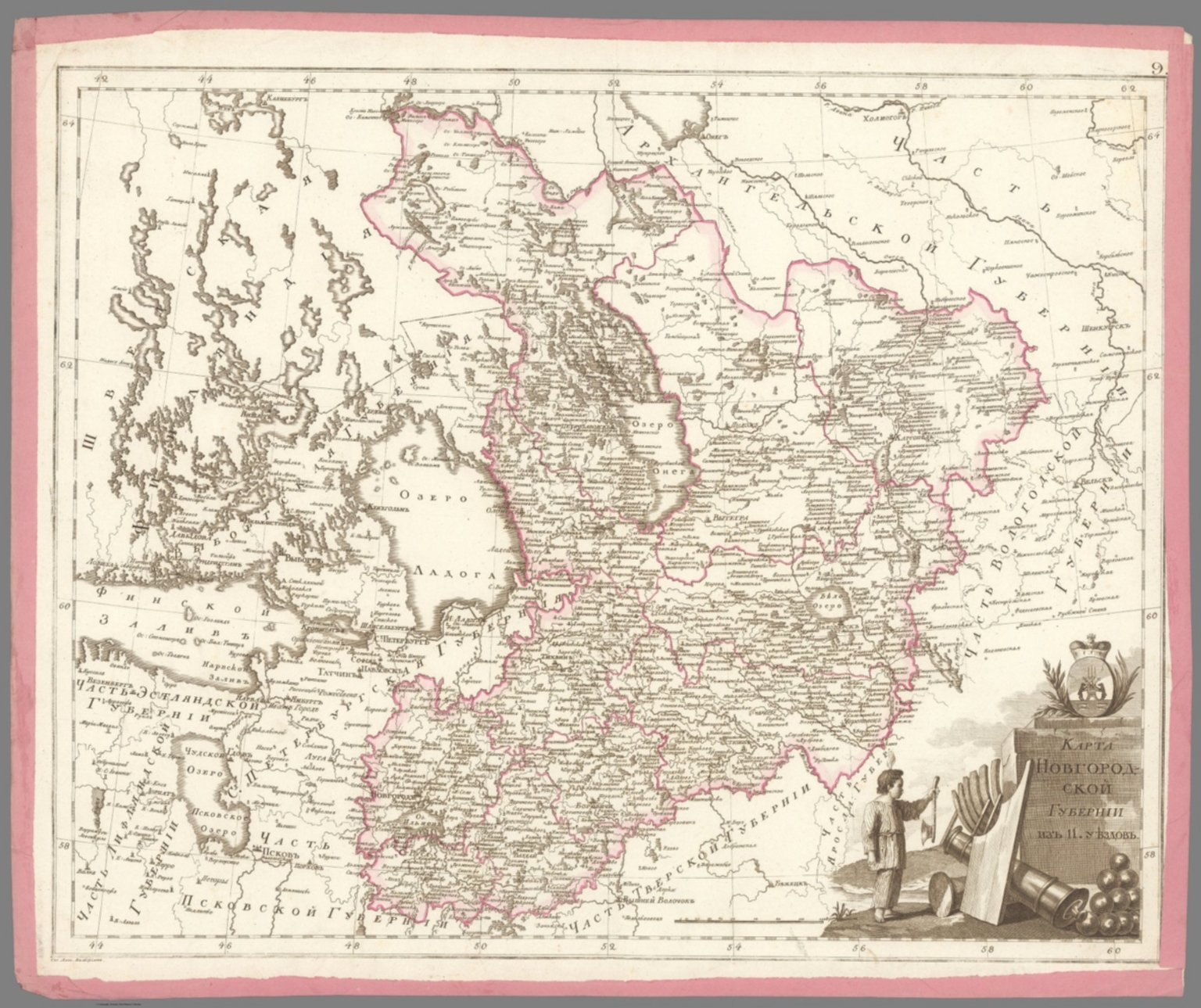
9. Карта Новгородской губернии из 11 уездов. [Map of the Novgorod Province of 11 Districts].
- Publication Year :
- 1800
- Publisher :
- Географический департамент [Geographical Department], St. Petersburg, 1800.
-
Abstract
- "Folio Atlas, but here with Complete Contents contemporarily left unbound and presented as 47 separate copper engraved leaves, each with contemporary pink paper edging. Extremely rare and historically important – the finest Enlightenment Era atlas of the Russian Empire, being the second edition of the work, made on the orders of Czar Paul I to present his new jurisdictional reforms, created by Aleksandr Mikhailovich Wilbrecht, the Chief Geographer and Cartographer to the Imperial Court, from the best sources and surveys, a complete example with 43 maps and 2 preliminary leaves, including a giant 3-sheet general map of the Russian Empire with an important inset depicting the Gulf of Alaska and northern British Columbia coasts, dozens of maps of individual Russian ‘gubernia’ (provinces) of unprecedented accuracy, as well as a map focusing upon Alaska and Kamchatka predicated upon intelligence gained from numerous Russian and British exploring expeditions; all maps beautifully decorated with allegorical cartouches, with text in Russian Cyrillic, published in St. Petersburg by the Czar’s Geographical Department; an extraordinary example clearly never bound, but preserved ‘in plano’ with all leaves with original outline hand colour and contemporary pink paper edging. This work is the finest Enlightenment Era atlas of the Russian Empire (which then included Alaska), and one of the foundational monuments of Russian scientific cartography and geographic intelligence. It is the revised second edition of a work first issued in 1792, and was made by Aleksandr Mikhailovich Wilbrecht, an exceedingly talented geographer, cartographer, mathematician and astronomer, who was the chief geographer and mapmaker to the Imperial Court. This revised edition of the atlas was created on the orders of Czar Paul I especially to show the empire’s new internal jurisdictions which were imposed per his reforms. The folio atlas features 43 maps, including a giant 3-sheet general map of the entire Russian Empire featuring an inset bearing a historically significant map depicting Alaska and much of the coast of British Columbia; individual maps of all of Russia’s first-level jurisdictions predicated upon the best surveys and sources; plus, a large format map of Kamchatka, Alaska and the northern BC Coast, predated upon intelligence from ground-breaking exploring expeditions. All maps are beautifully adored with allegorical cartouches that portray Russia to be a powerful, autocratic state, enlightened by science, culture and commerce, and which vanquishes its enemies. The present example of the atlas is complete, featuring 47 engraved leaves (2 preliminaries, and 43 maps on 45 leaves – the maximum called for); however, it was clearly never bound (the sheets are of dissonant sizes), with the borders of each sheet contemporarily edged with pink paper, allowing the maps to be conveniently enjoyed in plano. The first edition of the atlas, Российский атлас, из сорока четырёх карт состоящий и на сорок два наместничества империю разделяющий [Russian Atlas, consisting of Forty- Four Maps and dividing the Empire into Forty-Two Vice-royalties] (1792), was created by Wilbrecht on the orders of Empress Catherine II the Great (r. 1762-96) to show the new internal jurisdictions of the Russian Empire as imposed by her decree, ‘Institutions for the Management of the Provinces’ (November 7, 1775). Changing the nature and boundaries of the first-level jurisdictions in Russa was not simply a bureaucratic matter, but rather it had a profound impact upon land rights, taxation and economic and infrastructure development. Catherine II’s jurisdictional reforms, which were fully implemented in 1785, saw the empire divided into 38 наместничества (namestnichestva / vice-royalties), 3 provinces, 1 region and 1 special autonomous entity (governed by the Don Cossacks). During the 1790s, Catherine ordered further revisions to the Russian jurisdictions, such that upon her death, in 1796, the empire had 48 namestnichestva. The Wilbrecht atlas was only the second official atlas of the Russian Empire, having been preceded only by the Imperial Academy of Sciences’s Атлас Российской, состоящий из девятнадцати специальных карт… [The Russian Atlas, consisting of Nineteen Special Maps…] (St. Petersburg, 1745), which while a triumph in its time, by the 1790s was considered so outdated as to be practically obsolete. Catherine II’s son and successor, Czar Paul I (r. 1796 - 1801), a clinically insane ruler (who was eventually murdered on the orders of his own son!) absolutely despised his mother and went to great efforts to erase or change virtually anything that he attributed to her rule – including her jurisdictional reforms. He dissolved the 51 namestnichestva and converted them into 42 губе́рния (gubernia / provinces), an act which had significant effects upon public affairs across the empire. Paul I’s jurisdictional reforms naturally made the 1792 Wilbrecht atlas in good measure obsolete. The present 1800 edition of the atlas features largely the same maps and topographical content but sees the plates heavily reworked to show the new jurisdictions, with the titles altered accordingly (ex. on the Title Page and on Map no. 1, Catherine II’s cypher had been replaced by that of Paul I). The atlas fully preserves its important depictions of the Alaska and the northern BC coasts. To clear up any confusion, in the period between 1792 and 1800, Wilbrecht seemingly issued many of the atlas’s constituent maps separately, while groupings of maps were consolidated into what seems to have been atlas factice, such that many surviving examples of the atlas, even some held by elite institutions, are today found incomplete. Thus, the present example is notable for being complete with the maximum number of maps called for. * While the present example of the Wilbrecht Atlas is not bound, it features all the contents as called for, including: 1 Title Page, 1 Contents Register, and 43 maps (1 of which is comprised of 3 un-joined sheets). Some Highlights of the Atlas All the maps in the atlas are of very high quality, and the individual maps of the gubernia are the finest and, in many cases, the first accurate maps of these regions. They are predicated upon a composite of sources, in some cases, good scientific surveys, while accompanied by spectacular iconographic adornment. From an international perspective, the most significant elements are the depictions of the Russian Far East, Russian America (Alaska), and the adjacent coastlines of what is today British Columbia, as the true scientific conception of these regions was then emerging due to on-going exploring expeditions conducted by both Russian and British mariners. Map no. 42B., Восточная часть Иркутской губернии с прилежащими островами и западным берегом Америки [The Eastern Part of the Irkutsk Province with Adjacent Islands and the Western Coast of America], showcases a historically important depiction of Alaska and Kamchatka, derived from expeditions ranging from the 1720s to the 1780s. It is derived from Wilbrecht’s separately issued Карта представляющая открытия Российских мореплавателей на Тихом океане и английского капитана Кукка [Map representing the Discoveries of Russian Navigators in the Pacific Ocean and of the English Captain Cook] (1787), although its projection is quite different. For the littoral areas of Alaska, the map shows a sophisticated awareness of the pre-Cook Russian expeditions of Vitus Bering, Aleksei Chirikov, Pyotyr Krenitsyn and Martin Spanberg, etc., while fully embracing the discoveries from Cook’s Third Voyage (1778-9). The map also presents recent revelations due to the likes of Gerasim Ismailov, who discovered the Kenai Peninsula, and Dimitry Bocharov’s exploration of Kodiak Island and the Alaska Peninsula. In the deep interior (in the modern Northwest Territories), the map shows the discoveries of Samuel Hearn. In a similar vein, the inset on Map No. 1 (the general map of the Russian Empire), Карта представляющая частьзападного берега Америки от полуострова Аляски до залива Нутки положеннаго по новейшим открытиям зделанным Российскими и Английскими мореплавателями в 1784, 1786 и 1787 годах [A Map Representing Part of the Western Coast of America from the Alaska Peninsula to Nootka Bay based on the Latest Discoveries made by Russian and English Navigators in the years 1784, 1786 and 1787], shows the Pacific coast of North America, from the base of the Alaska Peninsula, in the northwest, down the just past Nootka Sound, Vancouver Island, in the southeast. The depiction of the Alaska coast is, in some ways, more advanced than that of Map 42B, especially with respect to its portrayal of places like the Kodiak Archipelago and Prince William Sound. The BC Coast shows an awareness of the discoveries of George Dixon and Nathaniel Portlock (1786-7), especially with regards to the Queen Charlotte Islands (Haida Gwaii) and vicinity. The mapping of north-central Siberia showcased by Map No. 41. Карта Тобольской губернии из 16 уездов [Map of the Tobolsk Province of 16 Counties], is quite interesting, capturing such details as the locations of villages, winter encampments, fortresses, monasteries, mines, salt and fishing works, and the routes of the exploration expeditions of Stepan Malygin (1734-5), Aleksei Ivanovich Skuratov (1734-5), Dmitry Ovtsyn (1735), Muraviev & Pavlov (1737) and Fedor Rozmyslov (1768), while also noting the place where Willem Barents’s expedition wintered in 1596. Aleksandr Mikhailovich Wilbrecht: Leading Russian Cartographer of the Enlightnement Aleksandr Mikhailovich Wilbrecht [Александр Михайлович Вильбрехт] (1757 - 1823) was a cartographer, geographer, astronomer and mathematician, who was the most important mapmaker in the Russian Empire during the late 18th and early 19th centuries, and generally a major force in Enlightenment science in the country. Born to an affluent St. Peterburg family, of partial German ancestry, Wilbrecht studied at the Academy of Arts and the School of the Army Noble Corps. After his graduation, he became a map draughtsman at the Geographical Department of the Imperial Academy of Sciences, before working in more senior roles at the Geographical Department of the Cabinet, the Military Topographic Depot, and the Geographical Department of the Ministry of Education. Wilbrecht came to the personal attention of Catherine the Great and, in 1785, was appointed to head the Higher School of Mathematics of the Imperial Mining School, as well as being the Chief Geographer of the Geographical Department of the Cabinet of Her Imperial Majesty. In these capacities, Wilbrecht’s greatest achievement was the present atlas of the Russian Empire (1792, 1800), with other highlights including his important map of the North Pacific, Карта представляющая открытия Российских мореплавателей на Тихом океане и английского капитана Кукка [A Map Representing the Discoveries of Russian Navigators in the Pacific Ocean and the English Captain Cook] (1787); Карта театра войны Российской империи против шведов сочиненная [Map of the Theatre of War of the Russian Empire against the Swedes, Composed] (1789); and the Подробная карта Российской империи и близлежащих заграничных владений [A Detailed Map of the Russian Empire and nearby Foreign Possessions] (1804, revised 1816), nicknamed the “Stolist Map” a colossal 100-sheet map of the European Russia. As the Russia’s leading geographic educator, Wilbrecht published the important works Новый Атлас или собрание карт всех частей земного шара, почерпнутый из разных сочинителей и напечатанный в Санкт-Петербурге для употребления Юношества в 1793 году при Горном училище [The New Atlas or a Collection of Maps of all Parts of the Globe, drawn from Different Writers and Printed in St. Petersburg for the Use of Youth in 1793 at the Mining School] (1793) and Атлас Российской империи изданной для употребления юношества [Atlas of the Russian Empire published for the Use of the Youth] (1794). Late in life, Wilbrecht became the Director of the Military Topographic Depot, whereupon he introduced top-notch scientific cartography to the Russian Army. A Note on Rarity The atlas, in either the 1792 or 1800 editions, and its intermediate variations, is very rare, especially as complete with all maps as called for in the registers. While there are surely several complete examples of the atlas in various Russian institutions, the only complete example of the 1800 edition we could is trace is held by the National Library of Russia (St. Petersburg). Outside of Russia, the only complete examples of the atlas we can locate are two 1792 editions, held by the Royal Geographical Society and the Beinecke Library (Yale University), although it is possible that there could be a couple more examples that are not properly catalogued online. Incomplete examples of the 1792 edition are held by the Harvard University Library, British Library and the National Library of Scotland, while an incomplete example of the 1800 edition is held by the University of California-Berkeley. The only complete example of the atlas we can trace as having been on the market since 1969 is for an example of the 1792 edition, sold in 2006 at Bonhams’s New York. A substantially incomplete example of the 1792 edition, with only 30 maps, was sold at Sotheby’s London in 2019. (Alexander Johnson/Dasa Pahor, 2023)<br />National Library of Russia (St. Petersburg): К 1-Росс 8/14; cf. [1792 ed.:] 1792: Royal Geographical Society: mr 1.C.112, Beinecke Library (Yale University): 1976 Folio 105; Leo BAGROW, ed. Henry W. Castner, A History of Russian Cartography up to 1800 (Wolfe Island, Ontario: Walker Press, 1975), Part V, pp. 212, 215.
- Subjects :
- Russia
Subjects
Details
- Database :
- LUNA Commons
- Publication Type :
- Map
- Accession number :
- edsluc.RUMSEY.8.1.356363.90123303
- Document Type :
- National Atlas<br />Atlas Map