Search

Your search keyword '"Yeager, E."' showing total 371 results

Search Constraints

Start Over You searched for: Author "Yeager, E." Remove constraint Author: "Yeager, E."
371 results on '"Yeager, E."'

Search Results

1. On the Corr\'adi-Hajnal Theorem and a question of Dirac

2. The (2k-1)-connected multigraphs with at most k-1 disjoint cycles

5. Illinois. Drawn by J.H. Young. Engraved by J.H. Young & E. Yeager. Philadelphia, Published by Anthony Finley 1834. (to accompany) A new general atlas, comprising a complete set of maps, representing the grand divisions of the globe ... 1836.

6. (Contents to) A New Universal Atlas Containing Maps of the various Empires, Kingdoms, States and Republics Of The World. With a special map of each of the United States, Plans of Cities &c. Comprehended in eighty one sheets and forming a series of One Hundred And Forty Five Maps, Plans And Sections ... Philadelphia, Charles Desilver, 714 Chesnut Street. 1859. Entered ... 1859, by Charles Desilver ... Pennsylvania. (title page by) J. Knight Sc.

7. A new map of the United States of America. 5-6. By J.H. Young. Philadelphia. Published by Charles Desilver, No. 714 Chesnut St. 1959. Engraved by J.L. Hazzard & E. Yeager. Entered ... 1859, by Charles Desilver ... Pennsylvania. (insets) Gold Region of California. (and) District of Columbia. (to accompany) A New Universal Atlas Containing Maps of the various Empires, Kingdoms, States and Republics Of The World.

8. (Title Page to) A New Universal Atlas Containing Maps of the various Empires, Kingdoms, States and Republics Of The World. With a special map of each of the United States, Plans of Cities &c. Comprehended in eighty one sheets and forming a series of One Hundred And Forty Five Maps, Plans And Sections ... Philadelphia, Charles Desilver, 714 Chesnut Street. 1859. Entered ... 1859, by Charles Desilver ... Pennsylvania. (title page by) J. Knight Sc.

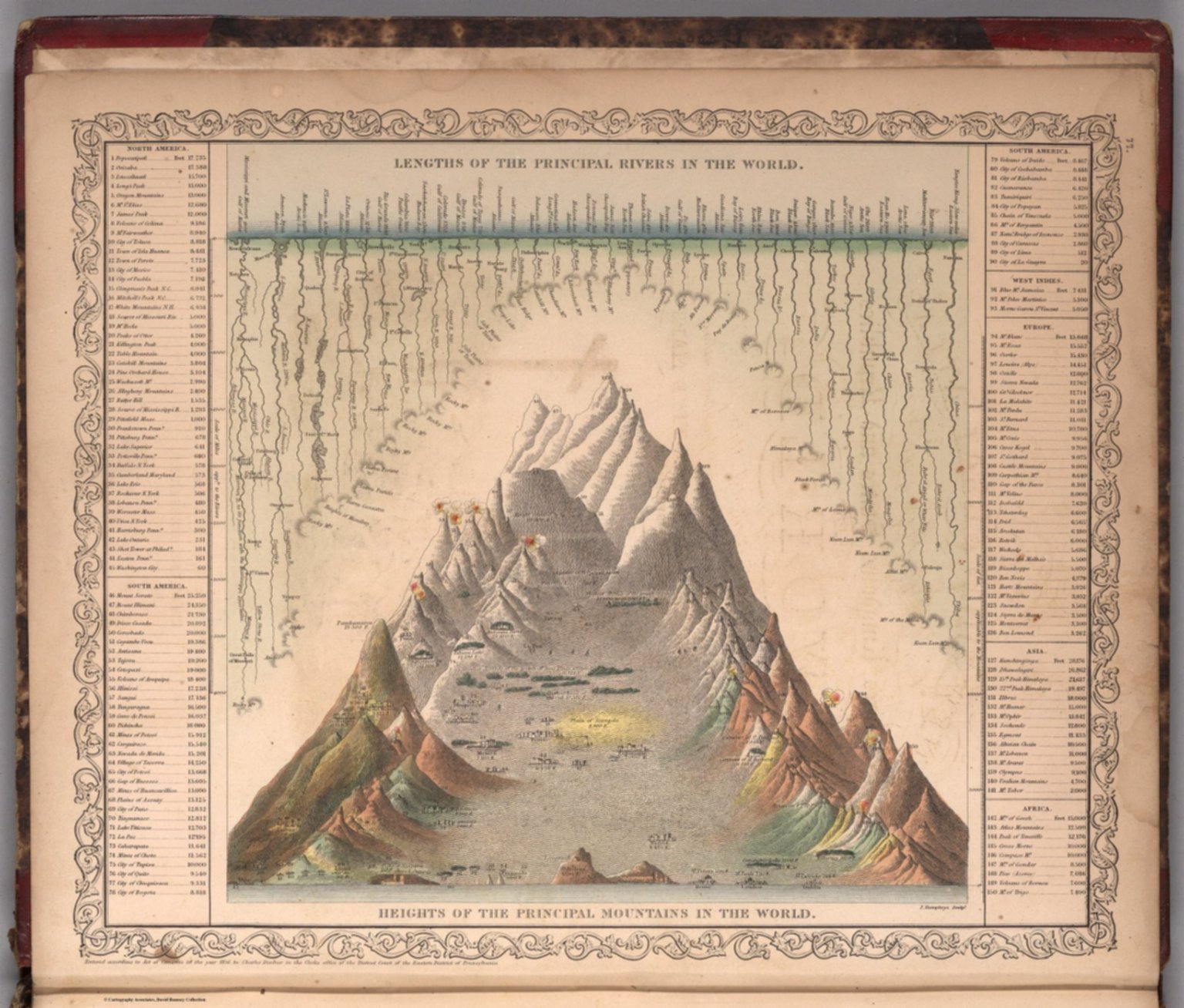
9. Lengths of the Principal Rivers in the World. Heights of the Principal Mountains in the World. F. Humphrys, Sculpt. Entered according to Act of Congress in the year 1856 by Charles Desilver in the Clerk's office if the District Court of the Eastern District of Pennsylvania. (to accompany) A New Universal Atlas Containing Maps of the various Empires, Kingdoms, States and Republics Of The World. 1859.

10. A New Map of the United States of America by J.H. Young. Philadelphia, Published By Charles Desilver, No. 1229 Chesnut Street. Entered according to Act of Congress in the year 1860 by Charles Desilver in the Clerk's office if the District Court of the Eastern District of Pennsylvania. 6. Engraved by J.L. Hazzard & E. Yeager.

11. Mitchell's Reference & Distance Map Of The United States. By J.H. Young. Published By S. Augustus Mitchell. Philadelphia: For Sale By S. Augustus Mitchell, No. 8-1/2 South Seventh Street. 1845. Engraved by J.H. Young, F. Dankworth, E. Yeager & E. F. Woodward. Entered ... 1845 by S. Augustus Mitchell ... Pennsylvania. (illustration) Designed by W. Mason. (inset) A General Map Of The United States with the contiguous British & Mexican Possessions. (with 10 additional inset maps).

12. The Tourist's Pocket Map Of The State Of Kentucky Exhibiting Its Internal Improvements Roads Distances &c. by J.H. Young. Philadelphia: Published By S. Augustus Mitchell. 1850. Sold By Thomas, Cowperthwait & Co. No. 253 Market Street. Entered ... 1834 by S. Augustus Mitchell ... Pennsylvania. Engraved by Edward Yeager. (inset) Vicinity Of Louisville. (inset) Vicinity Of Frankfort & Lexington.

13. (Covers to) The Tourist's Pocket Map Of The State Of Kentucky Exhibiting Its Internal Improvements Roads Distances &c. by J.H. Young. Philadelphia: Published By S. Augustus Mitchell. 1850. Sold By Thomas, Cowperthwait & Co. No. 253 Market Street. Entered ... 1834 by S. Augustus Mitchell ... Pennsylvania. Engraved by Edward Yeager. (inset) Vicinity Of Louisville. (inset) Vicinity Of Frankfort & Lexington.

14. Mitchell's Reference & Distance Map Of The United States. By J.H. Young. Published By S. Augustus Mitchell. Philadelphia: For Sale By R.L. Barnes, No. 50 North Fourth Street, 1841. Engraved by J.H. Young, F. Dankworth, E. Yeager & E. F. Woodward. Entered ... 1833 by S. Augustus Mitchell ... Pennsylvania ... (illustration) Designed by W. Mason. (inset) A General Map Of The United States with the contiguous British & Mexican Possessions. (with 10 additional inset maps).

15. Mitchell's Reference & Distance Map Of The United States By J.H. Young. Published By S. Augustus Mitchell. Philadelphia For Sale By Mitchell & Hinman, No. 6 North Fifth Street 1836. Engraved by J.H. Young, F. Dankworth, E. Yeager & E. F. Woodward. Entered ... 1833 by S. Augustus Mitchell ... Pennsylvania ... (illustration) Designed by W. Mason. (inset) A General Map Of The United States with the contiguous British & Mexican Possessions. (with 12 additional inset maps).

16. Reference & Distance Map Of The United States By J.H. Young. Published By S. Augustus Mitchell. Philadelphia For Sale By Mitchell & Hinman, No. 6 North Fifth Street 1834. Engraved by J.H. Young, F. Dankworth, E. Yeager & E. F. Woodward. Entered ... 1833 by S. Augustus Mitchell ... Pennsylvania ... (illustration) Designed by W. Mason. (inset) A General Map Of The United States with the contiguous British & Mexican Possessions. (with 12 additional inset maps).

17. (Covers to) Reference & Distance Map Of The United States By J.H. Young. Published By S. Augustus Mitchell. Philadelphia For Sale By Mitchell & Hinman, No. 6 North Fifth Street 1834. Engraved by J.H. Young, F. Dankworth, E. Yeager & E. F. Woodward. Entered ... 1833 by S. Augustus Mitchell ... Pennsylvania ... (illustration) Designed by W. Mason. (inset) A General Map Of The United States with the contiguous British & Mexican Possessions. (with 12 additional inset maps).

18. A New Map of the United States of America by J.H. Young. Philadelphia, Published By Charles Desilver, No. 714 Chestnut Street. Entered according to Act of Congress in the year 1856 by Charles Desilver in the Clerk's office if the District Court of the Eastern District of Pennsylvania. 6. Engraved by J.L. Hazzard & E. Yeager.

20. (Covers to) A New Map Of The United States of America By J.H. Young. Philadelphia Published By Charles DeSilver 251 Market St. 1857. Entered ... 1856 by Charles Desilver ... Pennsylvania. Engraved by J.L Hazzard & E. Yeager. (inset) Gold Region Of California. (inset) District Of Columbia.

21. A New Map Of The United States of America By J.H. Young. Philadelphia Published By Charles DeSilver 251 Market St. 1857. Entered ... 1856 by Charles Desilver ... Pennsylvania. Engraved by J.L Hazzard & E. Yeager. (inset) Gold Region Of California. (inset) District Of Columbia.

22. A New Map of the United States. By J.H. Young. Published By S. Augustus Mitchell. Philadelphia: For Sale By Mitchell & Hinman. No. 6 North Fifth Street, 1834. Engraved by J.H. Young, F. Dankworth, E. Yeager, & E.F. Woodward. Entered ... 1833 by S. Augustus Mitchell ... Pennsylvania. (title illustration) Designed by W. Mason. (inset) A General Map Of The United States with the contiguous British & Mexican Possessions. (with 12 additional inset maps).

23. Mitchell's Reference & Distance Map Of The United States By J.H. Young. Published By S. Augustus Mitchell. Philadelphia For Sale By Mitchell & Hinman, No. 6 North Fifth Street 1834. Engraved by J.H. Young, F. Dankworth, E. Yeager & E. F. Woodward. Entered ... 1833 by S. Augustus Mitchell ... Pennsylvania ... (illustration) Designed by W. Mason. (inset) A General Map Of The United States with the contiguous British & Mexican Possessions. (with 12 additional inset maps).

24. (Covers to) Mitchell's Reference & Distance Map Of The United States By J.H. Young. Published By S. Augustus Mitchell. Philadelphia For Sale By Mitchell & Hinman, No. 6 North Fifth Street 1834. Engraved by J.H. Young, F. Dankworth, E. Yeager & E. F. Woodward. Entered ... 1833 by S. Augustus Mitchell ... Pennsylvania ... (illustration) Designed by W. Mason. (inset) A General Map Of The United States with the contiguous British & Mexican Possessions. (with 12 additional inset maps).

25. Mitchell's New Traveller's Guide Through The United States, Showing the Rail Roads, Canals, Stage Roads &c. With Distances from Place to Place. Drawn and Engraved by I.S. Drake & J.L. Hazzard. Philadelphia 1856. (with 5 inset maps) Map of New England or Eastern States; Map of Maritime and Overland Routes to California; Map of the Gold and Quicksilver District of California; Map of Coper Mine Region; Vicinity of Niagara Falls. Published by Charles Desilver, No. 253 Market St. Entered ... 1856 by Charles Desilver... Pennsylvania.

26. (Title page to) Mitchell's New Traveller's Guide Through The United States and the Canadas, Containing The Principal Cities And Towns. Alphabetically Arranged, Together with Rail Road, Steamboat, Stage, and Canal Routes, With table of Places, and Distances from Place to Place. Illustrated By An Accurate Map Of The United States, Showing the Lines of Finished Rail Roads, And their More Important Connections. Philadelphia: Charles Desilver, 253 Market Street. 1856. (on verso) Entered ... 1855, by Charles Desilver ... Pennsylvania.

27. A New Map Of The United States of America. By J.H. Young. Philadelphia. (with 2 inset maps) Gold Regions of California and District of Columbia. Published by Charles Desilver, No. 253 Market St.

28. (Covers to) Mitchell's New Traveller's Guide Through The United States and the Canadas, Containing The Principal Cities And Towns ... Illustrated By An Accurate Map Of The United States ... Philadelphia: Charles Desilver, 253 Market Street. 1856. (on verso) Entered ... 1855, by Charles Desilver ... Pennsylvania. (with) A New Map Of The United States of America. By J.H. Young. Philadelphia. Published by Charles Desilver ... Entered ... 1856, by Charles Desilver ... Pennsylvania (with 2 inset maps). (with map) Mitchell's New Traveller's Guide Through The United States ... Drawn and Engraved by I.S. Drake & J.L. Hazzard. Philadelphia 1856. Published by Charles Desilver ... Entered ... 1856 by Charles Desilver... Pennsylvania (with 5 inset maps).

29. Mitchell's Reference & Distance Map Of The United States. By J.H. Young. Published By S. Augustus Mitchell. Philadelphia For Sale By S. Augustus Mitchell, N.E. corner of Market & Seventh Streets; 1845. Engraved by J.H. Young, F. Dankworth, E. Yeager & E. F. Woodward. Entered ... 1845 by S. Augustus Mitchell ... Pennsylvania ... (illustration) Designed by W. Mason. (inset) A General Map Of The United States with the contiguous British & Mexican Possessions. (with 10 additional inset maps).

30. Mitchell's Reference & Distance Map Of The United States By J.H. Young. Published By S. Augustus Mitchell. Philadelphia: For Sale By Mitchell & Hinman, No. 6 North Fifth Street 1835. Engraved by J.H. Young, F. Dankworth, E. Yeager & E. F. Woodward. Entered ... 1833 by S. Augustus Mitchell ... Pennsylvania ... (illustration) Designed by W. Mason. (inset) A General Map Of The United States with the contiguous British & Mexican Possessions. (with 12 additional inset maps).

31. Mitchell's New Traveller's Guide Through The United States ... Drawn and Engraved by J.L. Hazzard & I.S. Drake. Philadelphia. Published by Charles Desilver ... 1860. Entered ... 1848 by Charles Desilver ... Pennsylvania (with 5 inset maps). (with map) A New Map Of The United States of America. By J.H. Young. Philadelphia. Published By Charles Desilver ... Entered ... 1859, by Charles Desilver ... Pennsylvania (with 2 inset maps). (with text) Mitchell's New Traveller's Guide Through The United States and the Canadas, Containing The Principal Cities And Towns ... Illustrated By An Accurate Map Of The United States ... Philadelphia: Charles Desilver, No. 714 Chestnut Street, Opposite The Masonic Hall. 1860. (on verso) Entered ... 1859, by Charles Desilver ... Pennsylvania.

32. (Title Page to) Mitchell's New Traveller's Guide Through The United States and the Canadas, Containing The Principal Cities And Towns ... Illustrated By An Accurate Map Of The United States ... Philadelphia: Charles Desilver, No. 714 Chestnut Street, Opposite The Masonic Hall. 1860. (on verso) Entered ... 1859, by Charles Desilver ... Pennsylvania. (with) A New Map Of The United States of America. By J.H. Young. Philadelphia. Published By Charles Desilver ... Entered ... 1859, by Charles Desilver ... Pennsylvania (with 2 inset maps). (with map) Mitchell's New Traveller's Guide Through The United States ... Drawn and Engraved by J.L. Hazzard & I.S. Drake. Philadelphia. Published by Charles Desilver ... 1860. Entered ... 1848 by Charles Desilver ... Pennsylvania (with 5 inset maps).

33. A New Map Of The United States of America. By J.H. Young. Philadelphia. Published By Charles Desilver ... Entered ... 1859, by Charles Desilver ... Pennsylvania (with 2 inset maps). (with map) Mitchell's New Traveller's Guide Through The United States ... Drawn and Engraved by J.L. Hazzard & I.S. Drake. Philadelphia. Published by Charles Desilver ... 1860. Entered ... 1848 by Charles Desilver ... Pennsylvania (with 5 inset maps). (with text) Mitchell's New Traveller's Guide Through The United States and the Canadas, Containing The Principal Cities And Towns ... Illustrated By An Accurate Map Of The United States ... Philadelphia: Charles Desilver, No. 714 Chestnut Street, Opposite The Masonic Hall. 1860. (on verso) Entered ... 1859, by Charles Desilver ... Pennsylvania.

34. (Covers to) Mitchell's New Traveller's Guide Through The United States and the Canadas, Containing The Principal Cities And Towns ... Illustrated By An Accurate Map Of The United States ... Philadelphia: Charles Desilver, No. 714 Chestnut Street, Opposite The Masonic Hall. 1860. (on verso) Entered ... 1859, by Charles Desilver ... Pennsylvania. (with) A New Map Of The United States of America. By J.H. Young. Philadelphia. Published By Charles Desilver ... Entered ... 1859, by Charles Desilver ... Pennsylvania (with 2 inset maps). (with map) Mitchell's New Traveller's Guide Through The United States ... Drawn and Engraved by J.L. Hazzard & I.S. Drake. Philadelphia. Published by Charles Desilver ... 1860. Entered ... 1848 by Charles Desilver ... Pennsylvania (with 5 inset maps).

35. Preliminary chart of Key-West Harbor and approaches. From a trigonometrical survey under the direction of A.D. Bache, Superintendent of the Survey of the Coast of the United States. Triangulation by J.E. Hilgard, assistant. Topography by I.H. Adams, asst. Hydrography by the party under the command of Lt. John Rodgers, U.S.N. & asst. U.S.C.S. 1852. Second edition. Reduction for engraving by E.K. Knorr. Outlines & topography engraved by A. Rolle; lettering by Edw. Yeager. Electrotype copy no. 1 by G. Mathiot, U.S.C.S. (with logo) U.S. Coast Survey Office.

36. San Diego Entrance and approaches, California. From a trigonometrical survey under the direction of A.D. Bache, Superintendent of the Survey of the Coast of the United States. R.D. Cutts & Geo. Davidson, assistants and A.M. Harrison, sub assistant. Published in 1853. (with) General sketch of San Diego Bay and Los Coronados. Redd. drng. by F. Herbst. Engg. by S. Siebert, G. McCoy & E. Yeager. Electrotype copy no. 1 by G. Mathiot, U.S.C.S. No. 45. (with logo) U.S. Coast Survey Office.

37. Map Of Pennsylvania, constructed from the County Surveys authorized by the State; and other original Documents. Revised And Improved under the supervision of Wm. E. Morris, Civil Engineer ... Published By R.L. Barnes S.E. Corner Of Seventh And Market Sts. Philadelphia. 1849. Engraved by Edwd. Yeager. Entered ... 1848, by R.L. Barnes ... Pennsylvania. (title illustration) Drawn by F. Kearny.

38. Problem Department

44. Catalysts for ultrahigh current density oxygen cathodes for space fuel cell applications

45. Catalysts for ultrahigh current density oxygen cathodes for space fuel cell applications

Catalog

Books, media, physical & digital resources