1. مصر خريطه سى [Map of Egypt]

اركان خربيه عموميه مطبعه سى and [Erkan-i Harbiye-i Umumiye Matbaası / General War Printing Office]

شكوفه مقبل [Şukufe Mukbil]

Pasa, Ali Seref, Esref, Hafiz Ali, and Hasan Ferid

Reilly, Franz Johann Joseph von (1766-1820), Kininger, Vinzenz Georg, Schutz, Karl, Anville, Jean-Baptiste Bourguignon, d (1697-1782), and Stober, Jos

شكوفه مقبل [Şukufe Mukbil]

Meḥmed Remzi

Pasa, Ali Seref, Esref, Hafiz Ali, and Hasan Ferid

Meḥmed Remzi

United States. Central Intelligence Agency
4 color maps on 2 pages: Age of the Caliphs; Early Crusade; Ottoman Empire; Colonial past. Includes explanatory text., Color maps, with explanatory text, appendices: A. National facts. B. Index, gazetteer, and legend, and C. Selected bibliography, in two parts: Part one: Regions of Middle East. Part two: Nations of Middle East. Includes two folded color maps attached to atlas, on 1 sheet, back to back : Middle East. Scale 1:4,500,000. "802122 (R00015) 4-93," and Middle East oil and gas. Scale 1:4,500,000. "802094 (R00646, inset R00647) 4-93, and 35 small maps, with insets, covering population density, economic activity, land use historical data, location map, explanatory text and statistical diagrams. In 76 pages, in orange spiral bound covers 30.5x42. Title page includes : Preface. Notes: On verso of title page: "This document also may be purchased from: National Technical Information Service or Document Expediting (DOCEX) Project ..."

Cevdet, Mehmed Efendi
Date estimated., "A stunning, rare, seemingly unrecorded and exceedingly early Ottoman geographical primer broadside, made by one of the pioneers of modern education in the time of the Tanzimat, Mehmed Cevdet. Mehmed Cevdet Efendi, who signed the broadside in the upper part, was a pioneer of modern Ottoman education during the Tanzimat period in the second half of the 19th century. He received his education at the Imperial Military and Medical Schools and began his career at the latter institution from 1847 to 1849. Starting in 1857, he worked as an assistant at the Ministry of Public Education for 11 years. During this time, he also served as a geography teacher at the School of Public Administration (Mekteb-i Mülkiye-i Şahane) and later as a lecturer at Darülfünun, the first modern Ottoman university from 1863 onwards. The news about his new employment was published in the influential magazine Servet-i Fünun on September 5, 1863 (İbrahim Caner Turk, Osmanlı Devleti sureli yayınlarında maarif (eğitim), 2014, pp. 69-70)). Mehmed Cevdet gained attention in modern Turkish literature for his Ottoman alphabet primer called "Feyz’ul amim fi esrari’t-ta'lim" ( فيض العميم فى اسرار التعليم , also known as "Feyz ül-`amim fi esrar ul-ta`lim" or "Feyzu'l-amim fi Esraru'l-talim (Ozege) et al."). This primer is considered to be one of the pioneering publications of modern teaching and learning methods in Ottoman schools. In this work, Mehmed Cevdet aimed to create new methods for teaching children and adults, focusing on building connections between information rather than traditional rote memorization taught in madrasas. The book went through several editions and was republished until the early 20th century. Mehmed Cevdet later served as a director and teacher at Dâru'l Muallimîn-i Sıbyân (Teacher Training School, founded in 1868) and as a headmaster of several other important educational institutions. He retired in 1886 and passed away three years later. The Broadside in Focus The present seemingly unrecorded broadside was created, according to the inscription, during Mehmed Cevdet’s employment as an assistant at the Ministry of Public Education and as a geography teacher at the School of Public Administration (Mekteb-i Mülkiye-i Şahane), probably around 1860 or in the 1860s. The comprehensive geographical chart explains the basics of astronomy and modern geography in a clear and innovative way. The text in the upper three squares illustrates the meaning of the images above: the movement of the moon, spherical models of Earth, and movement of the sun. Below it lists the most important countries in the world by continents, along with their capitals, independent territories, population numbers, and their locations on maps. The last four rows indicate the countries bordering them in the four cardinal directions. A Note on Rarity The broadside is extremely rare, with no records in literature or other examples in institutions or on the market. The lithography of this size is very unusual for the time in the Ottoman Empire. It was probably printed only in small numbers and would be resulting in a very low survival rate until today." (Alexander Johnson/Dasa Pahor, 2024), Cf.: M. Alper Yalcinkaya, Learned Patriots Debating Science, State, and Society in the Nineteenth-Century Ottoman Empire, 2015 p. 74; Ekmeleddin İhsanoğlu, The House of Sciences, The First Modern University in the Muslim World, 2019, p. 26, Mehmet Ali Ayni, Aykut Kazancıgil, Darulfunun tarihi, 2007, p. 17. et al.

Cumhuriyet matbaası [State Press Turkey]
"A poster-size map, representing the judicial network in Turkey in 1927. The map represents the judicial network in Turkey in 1927, three years after the constitution founded independent courts and abolished religious courts. This chart illustrates the success of the new system. The map is a revised version of a similar map from 1925, which was printed by Zelich in Istanbul (featured in our December 2022 catalogue). Symbols and various lines showcase the modern judicial districts, different types of courts, law schools, various other institutions and inspectorates, with the system centered on the new capital, Ankara. The print was published in the last year of the use of the Ottoman script, before it was replaced by the Latin alphabet. The square in the left-hand side of the image contains explanations of various new symbols of the Ottoman alphabet, introduced in that year as a last attempt to modernize the old script and make it more suitable for writing modern words. We are not aware of any other examples of the map" (Alexander Johnson/Dasa Pahor, 2024)

Kiepert, Heinrich, 1818-1899

Efendi, Said
Istanbul: Imperial Military Office 1285 [1868 or 1869]., "The first wall map of the Vilayet Aleppo - A rare, large and impressive early Ottoman lithographed map. Vilayets – administrative divisions of the late Ottoman Empire were founded with the Vilayet Law of 21 January 1867, which was a part of the Tanzimat reform, trying to modernize the large and old-fashioned empire. This large impressive map of the Aleppo Vilayet, embracing a large area of south Anatolia, today’s Syria and Iraq along the Euphrates river, was made a year after the foundation of Vilayet Aleppo, a soon-to-be important political formation, from surveys, made on the field by the Ottomans. The north part of the map was based on the surveys of Fırka-i Islahiye, or a Reform Office, established by Ahmed Cevdet Pasha (1822 – 1895) and active in 1865 and 1866, with a goal to modernize the rural area of south Anatolia. The part of Syria and Iraq was surveyed by Said Efendi, a captain of the 4th Cavalry Regiment. Based on these researches, the map was drafted by the Military School in Istanbul and lithographed by the press of the same institution. The format of the map is exceedingly impressive for such an early time of lithography in Ottoman map-making. We could not find any other institutional examples nor any other examples on the market." (Alexander Johnson/Dasa Pahor, 2024) Translation of full title on map: The text is in Ottoman Turkish, which uses a modified Arabic script. Here's a translation of the content: "Map of the Province of Aleppo" "Edna and Mersin and Qozan and Piyas" "According to the official report of the Chief of the General Staff, Hussein Hissabik." "Aleppo and Urfa and Deir" "The gathering of the troops of the Army of Aleppo, and the administrative order is detailed in the attached chart. The timing and routes of the troop movements are specified." "As for the towns under the jurisdiction of the Army of Aleppo, the approved schedule and map indicate the following:" "Signatures: Saad Efendi and Ahmet Efendi." The text appears to be a military document, detailing the distribution and movements of troops in the province of Aleppo and surrounding areas. It specifies that the information is based on a report by a high-ranking official and includes signatures from two individuals likely responsible for the document.

Ministry of Justice Turkey
The image is the cover of an Ottoman-era calendar or almanac. Here is the translation and explanation of the elements present in the image: Translation: Title (Top Left): جریده عدلیه (Jarida Adliyye) - This translates to "The Justice Gazette." Top Right: سنه ۳ (Sene 3) - "Year 3" صادق ۲۸ (Sadık 28) - Likely refers to the specific date or edition number, "Sadık 28." Central Text: The text in the middle of the circular chart appears to be the Shahada (Islamic declaration of faith), commonly used in Islamic art and manuscripts. Labels around the circle: These are dates and years of the Ottoman calendar. Bottom Right (Legend): واحده (Wahde) - "Unit" بنگله جوز کوک فهمننده (Bengleh Joz Kuk Fahmenende) - This text is not entirely clear, but seems to be referring to some units or symbols explained further. صادقه (Sadık) - "Sadiq" or "Sadiqah," which might refer to a trustworthy or truthful measurement. Explanation: This cover represents a detailed calendar or almanac used during the Ottoman period. The circular chart in the middle might be depicting a timeline or various astronomical events, with blue and yellow circles likely representing different dates, events, or celestial bodies. The intricate lines connecting the center to the outer circle represent the connections or timelines of these events or dates. The content suggests the publication's focus on timekeeping, astronomical observations, and possibly religious or governmental matters, indicated by the presence of the Shahada in the center and the meticulous recording of dates. Visual Elements: Center: Arabic calligraphy, possibly religious text. Outer Circle: Alternating blue and yellow circles representing different time units. Connecting Lines: Indicative of connections or significant events between the central and outer elements. This cover reflects the rich tradition of scientific and religious scholarship in the Ottoman Empire, emphasizing the importance of accurate timekeeping and astronomical observations., "First editions, first impressions, of this attractive court journal from the fledglingTurkish Republic, employing various eye-catching methods of data visualization such as fan charts and circular bar plots in order to project courthouse statistics. This journal was first published in 1873 by the Ministry of Justice, under the same Cerfde-IMehakim, later Ceride- 1Adliye. It provided the latest news from theTanzimat Nizamiye courts, with summaries of statistics, rulings, and newly adopted regulations. "The publication of Cerfde-1Mehakimwas emblematic of the spirit of Tanzimat and the determination of the reformers to establish a new relationship between the Ottoman Empire, and its subjects, future citizens" (Levy-Aksu, p. 116). The journal was uninterrupted under the reign of Abdulhamid II. The present run dates from the early years of the Republic of Tiirkiye, shortly after the dissolution of the Ottoman Empire in 1922. It was a period of transition towards a civil law legal system, and it was not until February 1926 that the secular Turkish Civil Code was enacted. The run employs a number of innovative data visualizations, including bar and fan charts, graphs, circular bar plots and diagrams, pictorial tables, roundels, maps, and vignettes. They present data on documents processed by the Ministry of Justice and the chief prosecutor's office, prisoners, homicide crime rates, and the workload of civil and criminal courts. (Peter Harrington, 2024) See our 15819.000 for three additional covers (one of them a duplicate of this sets' first cover, 16065.001 Translation and text analytic in the note fields are done by ChatGPT4

شكوفه مقبل [Şukufe Mukbil]
Dimensions are sheet size., "49 full page hand-drawn maps in black ink, coloured with colour pencils, recto, and 21 flags verso, one page with manuscript in Ottoman and French in black and blue ink, other sheets blank, original brown cloth binding with gilt name of the author on the cover, hand-patterned endpapers (at least 3 maps cut out, repairs to cracks in the butters of endpapers, otherwise in a good condition). One of the earliest known atlases, made by an Ottoman and Islamic female mapmaker, designed in a wonderful minimalistic early art deco style This stunning WWI manuscript atlas of the world in art deco forms was made in 1916 by a female Ottoman student and it is an early, if not the first known atlas by a female mapmaker in the Islamic world. The author is signed as Şukufe Mukbil and the atlas was made as a school project. Each map is signed by a teacher, as “controlled”. The two inscriptions on the last page, made by the author and possibly a teacher (please see below), confirm this. The maps represent various continents, countries and parts of the world, some of them with railway systems. The maps are represented in unique minimalistic forms and coloured with attractive colours in outline. First Classes in Geography for Women in the Ottoman Empire - İnas Darülfünun The atlas was made in the time of a major feminist movement in the Ottoman Empire, when women demanded same rights as men, and could be possibly connected with the first Ottoman female university for women İnas Darülfünun, which was established in 1912 as a part of growing female emaciation in the Ottoman Empire and as a reply on similar foreign schools for girls. Geography and ethnography were obligatory subjects in the first year (Ali Arslan - Özlem Akpınar, İnas , Darülfünunu (1914- 1921) Osmanlı Bilimi Araştırmaları VI/2, 2005, p. 227). The classes, which started in October of 1914, were free and were in the first year attended by 22 girls, of which 20 graduated three years later. All together 53 female students received the diploma until 1919, when the university joined with the regular Istanbul university Darülfünun, which was until then only reserved for men. The initiative to joint with the male university was made in 1918 by a female student, a later famous author and feminist Şükûfe Nihal Başar (1896-1973), who in a few years became the first Ottoman female to finish the regular Ottoman university and the first official Ottoman mapmaker. She could be identical with Şükûfe Mukbil, who made our atlas. Date and Author The book is dated under the hand-written dedication at the end with a year, which first seems like 1322 AH or 1906 AD, but the borders of the countries on the maps suggest, that the atlas was made after the Balkan Wars, that is why the hand written date should be rather read as 1333 AH (please note the almost identical Arabic digits 2 and 3, when written per hand) or 1916 of the Christian calendar. The year 1916 also supports the image of the territory of Silistra, which was at the year juggled between Romania and Bulgaria. The author is signed on the cover as Şukufe Mukbil, a female Ottoman student. The atlas bears inscriptions by two hands on the verso of the last map. The first one says, that this is an extraordinary work by a female student, signed by Mehmed, probably a teacher. The dedication below in Ottoman and French was made by the author herself. She quotes, that she is giving this book to her female teacher as a present on November 1st 1333 (1916). Today no records are known yet about Şukufe Mukbil, which is not surprising, as most of the early data of Ottoman women were traditionally not recorded. She could be possibly identical with the first Ottoman female mapmaker Şükûfe Nihal (1896-1973), who entered İnas Darülfünun, the first Ottoman university for women in 1916, the same year that our atlas was made. She was 20 years old at the time, married for 4 years and mother of a small son. Previously schooled by foreign tutors and speaking several languages, she could only enter the university with the permission of her husband. Şükûfe would become the first Ottoman woman to finish the university along with the male students and the first women in the empire, who earned a degree in mapmaking. Şükûfe, who later filed for a divorce and married her fellow student, the geographer Ahmet Hamdi Başar (1897-1971), later became one of the most famous female poets of the early Turkish Republic and a fierce fighter for female rights. No researches so far have been made on her early work as a mapmaker. At the moment the question, if Şukufe Mukbil is identical to Şükûfe Nihal, who lived and was schooled in the same milieu at the same time, remains open. Until the surname law in Turkey in 1934, which was a part of the reformations of the old system under Atatürk, the family names were not fixed and they changed depending on the status, profession and place of living of the individual. The females were usually only referred to by their first name, followed by “Hanım”, meaning a woman. The name Mukbil means fortunate, fortune or fortuna, and could be adopted only for short period of time by the author. It is also possible, that this highly talented mapmaker never created any other recorded maps and decided to traditionally dedicate herself to a family life after finishing her education. In any case this exceptional, visually highly progressive atlas remains one of the earlier examples of mapmaking by a female author in the Ottoman Empire and in the Islamic World. We could not find any similar examples." (Alexander Johnson and Dasa Pahor, 2021)

Mercator, Gerhard, 1512-1594, Hondius, Jodocus, 1563-1612, and Hondius, Hendrik, 1597-1651
"This is the first edition with the name of Henricus Hondius on the title page. The Latin Atlas is enlarged with the same six new maps of French provinces as appeared in the 1619 French edition (1:113): (49) Saintonge, (54) Picardie, (55) Champagne, (56) Beauvais, (60) Bourbonnais, and (62) ~ercy. As in the 1619 French edition the 1585 Mercator map of France (map 46) is replaced by a 'new' one: Jodocus Hondius map of 1600, some copies of the 1623 edition have a later state of this map with the date altered to 1622. Mercator's map of Bohemia (map 106) is replaced by Blaeu's map of the same region." (Van der Krogt 1:105). This copy has unusually fine color. It was long held in a collection in Germany., Koeman Me 27A; van der Krogt 1:105

Ministry of Justice Turkey
Date estimated from cover., "3 issues of the Ottoman law magazine Cerîde-i Adliyye with 3 colourful statistic covers. Presented here are 3 issues of a Turkish governmental magazine in Ottoman language, published in 1924 and 1925. 3 title pages of the issues include unique graphical presentations of the governmental statistics, unlike any others in Turkey nor in the western countries. The charts represent the financial data of the government, court, agriculture etc. in patterns, mimicking the title of the main subject, and combine the visual aspect with the sophisticated data in surrealistic complicated patterns. The magazine was first published by the Ministry of Justice on December 18th, 1909, and is still issued as a bimonthly today. The name changed from the original Cerîde-i Mehâkim-i Adliyye to Cerîde-i Adliyye to Resmi Kararlar Dergisi, Adalet Dergisi and finally to Adalet Dergisi (The Journal of Justice). The magazines only rarely survive with original covers and we could not establish how many were issued with data visualization charts. In 2017, some of the covers of the magazines were included in the exhibition Gözlere Konuşmak or Speak to the Eyes. Visualizing Information from the Ottoman Era to the Republic at Studio-X, founded at the initiative of Columbia University Graduate School of Architecture, Planning and Preservation (GSAPP) in Istanbul. The magazine is scarce in the western Libraries. The Bavarian State Library and Orient-Institute in Istanbul house a complete series until no. 20 of 1929, as the Berlin State Library owes sporadic series. " (Alexander/Johnson, Dasa Pahor, 2021)

Ministry of Justice Turkey
September 1340 (1924), "3 issues of the Ottoman law magazine Cerîde-i Adliyye with 3 colourful statistic covers. Presented here are 3 issues of a Turkish governmental magazine in Ottoman language, published in 1924 and 1925. 3 title pages of the issues include unique graphical presentations of the governmental statistics, unlike any others in Turkey nor in the western countries. The charts represent the financial data of the government, court, agriculture etc. in patterns, mimicking the title of the main subject, and combine the visual aspect with the sophisticated data in surrealistic complicated patterns. The magazine was first published by the Ministry of Justice on December 18th, 1909, and is still issued as a bimonthly today. The name changed from the original Cerîde-i Mehâkim-i Adliyye to Cerîde-i Adliyye to Resmi Kararlar Dergisi, Adalet Dergisi and finally to Adalet Dergisi (The Journal of Justice). The magazines only rarely survive with original covers and we could not establish how many were issued with data visualization charts. In 2017, some of the covers of the magazines were included in the exhibition Gözlere Konuşmak or Speak to the Eyes. Visualizing Information from the Ottoman Era to the Republic at Studio-X, founded at the initiative of Columbia University Graduate School of Architecture, Planning and Preservation (GSAPP) in Istanbul. The magazine is scarce in the western Libraries. The Bavarian State Library and Orient-Institute in Istanbul house a complete series until no. 20 of 1929, as the Berlin State Library owes sporadic series. " (Alexander/Johnson, Dasa Pahor, 2021)

Anonymous
Date estimated., MILITARY ANTEBELLUM OTTOMAN MAP OF EAST & SOUTHEAST ANATOLIA AND THE CAUCASUS BORDERS. In Ottoman script (Old Turkish with Arabic letters). Extremely rare huge chromo-lithograph map in 24 sheets mounted on canvas, showing a large antebellum zone including the borders to Russia on the northeast, and to Armenia, Azerbaijan on the east, with Midyat (Mardin), Mosul, Mt. Cilo (Resko-Buzul) on the southeast; Kahta (Adiyaman), Munzur Mt., Divrigi (Sivas) on the west; the Black Sea on the north. In addition, it shows roads, mountains and hills, lakes, telegraphs and postways, and borders in different panels. An attractive map with its huge size and decorative surface. Several toponyms are underlined in red ink.

Lapie, M. (Pierre), 1779-1850
"Rare 15 Sheet Map of The Turkish Empire in Europe -- From the Library of General Nicolas Charles Oudinot Highly detailed map of the Western part of the Turkish Empire, compiled for Lapie and published by Charles Picquet. Includes inset maps of the Dardanelles, the environs of Istanbul, a plan of Salonica and a plan of Rhodes. A "nouvelle edition" of the map was issued in 1847. General Nicolas Charles Oudinot A final detail that gives this map particular importance is the identity of its former owner, Nicolas Charles Oudinot, 1st Comte Oudinot, 1st Duc de Reggio (1767 - 1848), and a Marshal of France. A fierce fighter, the man was wounded no less than 34 times during his military career! The only one of nine siblings to live past childhood, Oudinot joined the army without a noble pedigree, and therefore without a chance of high promotion. That all changed in 1792, with the outbreak of the French Revolution. In that year, Oudinot was elected lieutenant-colonel of the third battalion of the volunteers of the Meuse. After transfer to the regular army and admirable service in Belgium, he was promoted to the rank of general in June 1794 after the Battle of Kaiserslautern. From Belgium he shifted to the German and Swiss fronts, where he fought as a general of division and chief of staff to Andre Massena. Oudinot stood out at the Battle of Monzambano so much so that Napoleon himself presented him with a sword of honor, now known as the Legion d'Honneur. Napoleon did not forget him after he established his empire; now Emperor Napoleon recognized Oudinot again, this time with a Grand Cross of the Legion of Honor. During the Napoleonic Wars, Oudinot continued to acquit himself commendably. He was elected a member of the Chamber of Deputies, commanded a company of grenadiers nicknamed for him, and fought in battles from Vienna to Poland. In 1808, he was appointed governor of Erfurt and was made a Count of the French Empire. Finally, in 1809, after the Battle of Wagram, he was named a Marshal of France, France's highest military distinction. Oudinot continued to serve as an administrator in Holland and on the battlefield in the Russian campaign. After Napoleon's fall, Oudinot joined the Bourbon Restoration and stayed loyal to the King even after Napoleon's return in 1815. For his loyalty and service, he was named a peer of the realm. He served until 1823, when he participated in the French invasion of Spain. Then, he turned again to political and administrative appointments; he died while serving as governor of Les Invalides, at the veterans' hospital in Paris. Provenance Purchased at auction in Paris, from Artcuriel, Collections from the Castle of Malicorne Marshal Oudinot's Historical Souvenirs, June 13, 2017 (Lot 156). Rarity The map is quite rare. OCLC locates 3 examples (Princeton, British Library and BnF). We note only copy in The World Refolded (Bernard Shapero 2005, Lot 161 -- 2000 GBP)" (Ruderman, 2018), From The Library of General Nicholas Charles Oudinot

Zacharia, Captain, Ziya, Captain, and Mahir, Captain
"An exceedingly rare large Ottoman nautical chart of the Aegean Sea in two parts with in-set maps of most important ports. A stunning large Ottoman nautical chart in two parts (circa 120 cm x 98 cm / 47.2 x 38.6 inches, if assembled) represents the Aegean Sea, with Istanbul in the upper right part and Crete in the south. The inset maps represent the important ports. Manuscript additions in yellow and red mark lighthouses. The map was printed by the Naval Office, was based on an English draft and was corrected by Ottoman Captains Zacharia, Ziya and Mahir. All engraved Ottoman nautical charts are exceedingly rare and they only appear sporadically on the market. This is the first map in two parts in a notably good condition, that we have ever encountered. (Alexander Johnson and Dasa Pahor, 2023)

BINBASI HALIL IBRAHIM EFENDI, (Mekâtîb-i Fünûn-i Harbiye-i Sahâne'de topografya muallimi muavini)
"In Ottoman script (Old Turkish with Arabic letters). Scale: 1/50000. This map is one of the masterpieces of Ottoman cartographic history. This rare and attractive map shows the topography of Ioannina Greece (Ioannina often called Yannena within Greece, is the capital and largest city of the Ioannina regional unit and of Epirus, an administrative region in north-western Greece). The map includes several attractive hand-colored land views. A lower panoramic view of South Ioannina shows the Ottoman army deployed across the river and the bridge built by Sultan Mehmet II. The second one at the upper left of the map shows Loros village in Greece and Hamidiye Bridge on the river as an Ottoman architectural building. The third and fourth painted view shows the Castle of Ioannina with the Ottoman flag which is the fortified old town of the city of Ioannina in northwestern Greece. The present fortification dates largely to the reconstruction under Ali Pasha in the late Ottoman period, but incorporates also pre-existing Byzantine elements. The last vignette under the title part shows northern Greece and Rumeli (Roumeli). All views are captioned in Ottoman script with Arabic letters. The map includes the Ambracian Gulf, also known as the Gulf of Arta or the Gulf of Actium of the Ionian Sea on the south; and Loros Plains on the north. Binbasi [i.e. Major] Halil Ibrahim Efendi was a cartographer and topography teacher at the Ottoman Military School. He participated in the Greco-Turkish War of 1897 ('93 Harbi in Turkish). The Ottoman Military College or Imperial Military Staff College or Ottoman Army War College was a two-year military staff college of the Ottoman Empire. It was located in Constantinople (now Istanbul). Its mission was to educate staff officers for the Ottoman Army. The school, which was established in accordance with the decree of the Ottoman Sultan Abdülmecid I in 1845 and the decision taken by the Military Education Board consisting of Emin Pasha, Fuad Pasha, and Shaikh al-Islam Arif Hikmet Bey, started education and training in 1848 and Abdülkerim Pasha was appointed as the first principal. The Greco-Turkish War of 1897 or the Ottoman-Greek War of 1897 was a war fought between the Kingdom of Greece and the Ottoman Empire. Its immediate cause involved the status of the Ottoman province of Crete, whose Greek-majority population had long desired union with Greece. Despite the Ottoman victory on the field, an autonomous Cretan State under Ottoman suzerainty was established the following year (as a result of the intervention of the Great Powers after the war), with Prince George of Greece and Denmark as its first High Commissioner. (Wikipedia). We can't trace any copy in OCLC. One copy in SALT of Turkey, no copy in TBMM Library. Extremely rare." (Alican Aikin, 2023)

Lapie, Pierre M., 1779-1850
First edition was 1816., "Pierre Lapie's 1828 Map of the Ottoman Empire -- Issued on the Occasion of the Russo-Turkish War -- From the Library of General Nicolas Charles Oudinot. Large engraved folding map of the Ottoman Empire in Asia and Europe, by Pierre Lapie, issued just before the decisive Ottoman defeat that would start the Empire's ultimate decline. Russo-Turkish War Pierre Lapie issued several maps of the Ottoman Empire into the 1820s, with the present edition issued during the first year of the Russo-Turkish War (1828-29). The Greek struggle for independence sparked the Russo-Turkish War of 1828-29, in which Russian forces advanced into Bulgaria, the Caucasus, and northeastern Anatolia itself before the Turks sued for peace. The resulting Treaty of Edirne (Sept. 14, 1829) gave Russia most of the eastern shore of the Black Sea, and Turkey recognized Russian sovereignty over Georgia and parts of present-day Armenia. This map shows Ottoman territory before the substantial losses suffered in that war, which also marked a turning point on the ultimate downward trend that would last until its defeat and dissolution in the first quarter of the 20th century. This edition includes a pastedown key that explains the states identified: the Ottoman Empire; Russian Empire; Austrian Empire; Kingdom of Persia; and Greece. Interestingly, the map names and delineates the United States of the Ionian Islands, an amical protectorate of the United Kingdom from 1815 to 1864. It was the successor state of the Septinsular Republic. The map belongs to a class of large-scale modern surveys published by Pierre Lapie in the first quarter of the 19th century. These maps were on a larger scale and more detailed than any of his competitors at home or abroad. Pierre M. Lapie was a French cartographer and engraver. He was the father of cartographer Alexandre Emile Lapie. Lapie was a Colonel in the French army, where he worked in the corps of topographical engineers. Lapie worked closely with his son and published works together and individually. General Nicolas Charles Oudinot A final detail that gives this map particular importance is the identity of its former owner, Nicolas Charles Oudinot, 1st Comte Oudinot, 1st Duc de Reggio (1767 - 1848), and a Marshal of France. A fierce fighter, the man was wounded no less than 34 times during his military career! The only one of nine siblings to live past childhood, Oudinot joined the army without a noble pedigree, and therefore without a chance of high promotion. That all changed in 1792, with the outbreak of the French Revolution. In that year, Oudinot was elected lieutenant-colonel of the third battalion of the volunteers of the Meuse. After transfer to the regular army and admirable service in Belgium, he was promoted to the rank of general in June 1794 after the Battle of Kaiserslautern. From Belgium he shifted to the German and Swiss fronts, where he fought as a general of division and chief of staff to Andre Massena. Oudinot stood out at the Battle of Monzambano so much so that Napoleon himself presented him with a sword of honor, now known as the Legion d'Honneur. Napoleon did not forget him after he established his empire; now Emperor Napoleon recognized Oudinot again, this time with a Grand Cross of the Legion of Honor. During the Napoleonic Wars, Oudinot continued to acquit himself commendably. He was elected a member of the Chamber of Deputies, commanded a company of grenadiers nicknamed for him, and fought in battles from Vienna to Poland. In 1808, he was appointed governor of Erfurt and was made a Count of the French Empire. Finally, in 1809, after the Battle of Wagram, he was named a Marshal of France, France's highest military distinction. Oudinot continued to serve as an administrator in Holland and on the battlefield in the Russian campaign. After Napoleon's fall, Oudinot joined the Bourbon Restoration and stayed loyal to the King even after Napoleon's return in 1815. For his loyalty and service, he was named a peer of the realm. He served until 1823, when he participated in the French invasion of Spain. Then, he turned again to political and administrative appointments; he died while serving as governor of Les Invalides, at the veterans' hospital in Paris. Provenance Purchased at auction in Paris, from Artcuriel, Collections from the Castle of Malicorne Marshal Oudinot's Historical Souvenirs, June 13, 2017 (Lot 156)." (Ruderman, 2018), From the Library of General Nicolas Charles Oudinot.

Lapie, Pierre M., 1779-1850 and Orgiazzi, J.A.
Inset map of Instanbul at scale 1:46,000, "1828 Lapie-Orgiazzi Map of the Ottoman Empire -- Issued on the Occasion of the Russo-Turkish War -- From the Library of General Nicolas Charles Oudinot. Large engraved folding map of the Ottoman Empire in Asia and Europe, by Pierre Lapie and J. A. Orgiazzi, issued just before the decisive Ottoman defeat that would start the Empire's ultimate decline. The Orgiazzi-Lapie was issued in editions going back to the beginning of the 1820s. The map features a circular inset of Constantionple in the lower left corner. Russo-Turkish War Pierre Lapie issued several maps of the Ottoman Empire into the 1820s, with the present edition issued during the first year of the Russo-Turkish War (1828-29). The Greek struggle for independence sparked the Russo-Turkish War of 1828-29, in which Russian forces advanced into Bulgaria, the Caucasus, and northeastern Anatolia itself before the Turks sued for peace. The resulting Treaty of Edirne (Sept. 14, 1829) gave Russia most of the eastern shore of the Black Sea, and Turkey recognized Russian sovereignty over Georgia and parts of present-day Armenia. This map shows Ottoman territory before the substantial losses suffered in that war, which also marked a turning point on the ultimate downward trend that would last until its defeat and dissolution in the first quarter of the 20th century. This edition includes a pastedown key that explains the states identified: the Ottoman Empire; Russian Empire; Austrian Empire; Kingdom of Persia; and Greece. Interestingly, the map names and delineates the United States of the Ionian Islands, an amical protectorate of the United Kingdom from 1815 to 1864. It was the successor state of the Septinsular Republic. The map belongs to a class of large-scale modern surveys published by Pierre Lapie in the first quarter of the 19th century. These maps were on a larger scale and more detailed than any of his competitors at home or abroad. Pierre M. Lapie was a French cartographer and engraver. He was the father of cartographer Alexandre Emile Lapie. Lapie was a Colonel in the French army, where he worked in the corps of topographical engineers. Lapie worked closely with his son and published works together and individually. General Nicolas Charles Oudinot A final detail that gives this map particular importance is the identity of its former owner, Nicolas Charles Oudinot, 1st Comte Oudinot, 1st Duc de Reggio (1767 - 1848), and a Marshal of France. A fierce fighter, the man was wounded no less than 34 times during his military career! The only one of nine siblings to live past childhood, Oudinot joined the army without a noble pedigree, and therefore without a chance of high promotion. That all changed in 1792, with the outbreak of the French Revolution. In that year, Oudinot was elected lieutenant-colonel of the third battalion of the volunteers of the Meuse. After transfer to the regular army and admirable service in Belgium, he was promoted to the rank of general in June 1794 after the Battle of Kaiserslautern. From Belgium he shifted to the German and Swiss fronts, where he fought as a general of division and chief of staff to Andre Massena. Oudinot stood out at the Battle of Monzambano so much so that Napoleon himself presented him with a sword of honor, now known as the Legion d'Honneur. Napoleon did not forget him after he established his empire; now Emperor Napoleon recognized Oudinot again, this time with a Grand Cross of the Legion of Honor. During the Napoleonic Wars, Oudinot continued to acquit himself commendably. He was elected a member of the Chamber of Deputies, commanded a company of grenadiers nicknamed for him, and fought in battles from Vienna to Poland. In 1808, he was appointed governor of Erfurt and was made a Count of the French Empire. Finally, in 1809, after the Battle of Wagram, he was named a Marshal of France, France's highest military distinction. Oudinot continued to serve as an administrator in Holland and on the battlefield in the Russian campaign. After Napoleon's fall, Oudinot joined the Bourbon Restoration and stayed loyal to the King even after Napoleon's return in 1815. For his loyalty and service, he was named a peer of the realm. He served until 1823, when he participated in the French invasion of Spain. Then, he turned again to political and administrative appointments; he died while serving as governor of Les Invalides, at the veterans' hospital in Paris. Provenance Purchased at auction in Paris, from Artcuriel, Collections from the Castle of Malicorne Marshal Oudinot's Historical Souvenirs, June 13, 2017 (Lot 156)." (Ruderman, 2018, From the Library of General Nicolas Charles Oudinot.

Lapie, Pierre M., 1779-1850
One of several maps of the Ottoman Empire by Lapie made in the 1820-1850 period, large scale. See our other copies., From the Library of General Nicolas Charles Oudinot.

Lapie, Pierre M., 1779-1850
There was an edition of 1848. "This 1848 map of the Middle East and parts of Central and South Asia is by the French cartographer and engraver Pierre M. Lapie (1779-1850), a colonel in the French army and head of the topographical section in the Ministry of War. Accurate and beautifully detailed, the map reflects the high quality of French cartography, and military cartography in particular. The territory covered includes the Nile Valley and the Nile delta, Cyprus and present-day Turkey, the countries of the eastern Mediterranean, Persia, Afghanistan, and Bukhara and other khanates in Central Asia that within a few decades were to come under Russian rule. The map provides scales of distance in no fewer than nine different units: myriameters (10,000 meters), leagues, English miles, German miles, nautical miles, Turkish agachs, Persian fersangs, hours of walking or marching required to cover a given distance, and Russian versts. Paris is given as the prime meridian. The map at one time belonged to the Geographic Section, U.S. Department of State, but was transferred to the Library of Congress." World Digital Library.
اركان حربيه عموميه دائره سنك بشنجى فن شعبه سنده FIFTH DRAFTING DEPARTMENT OF THE GENERAL MILITARY OFFICE].
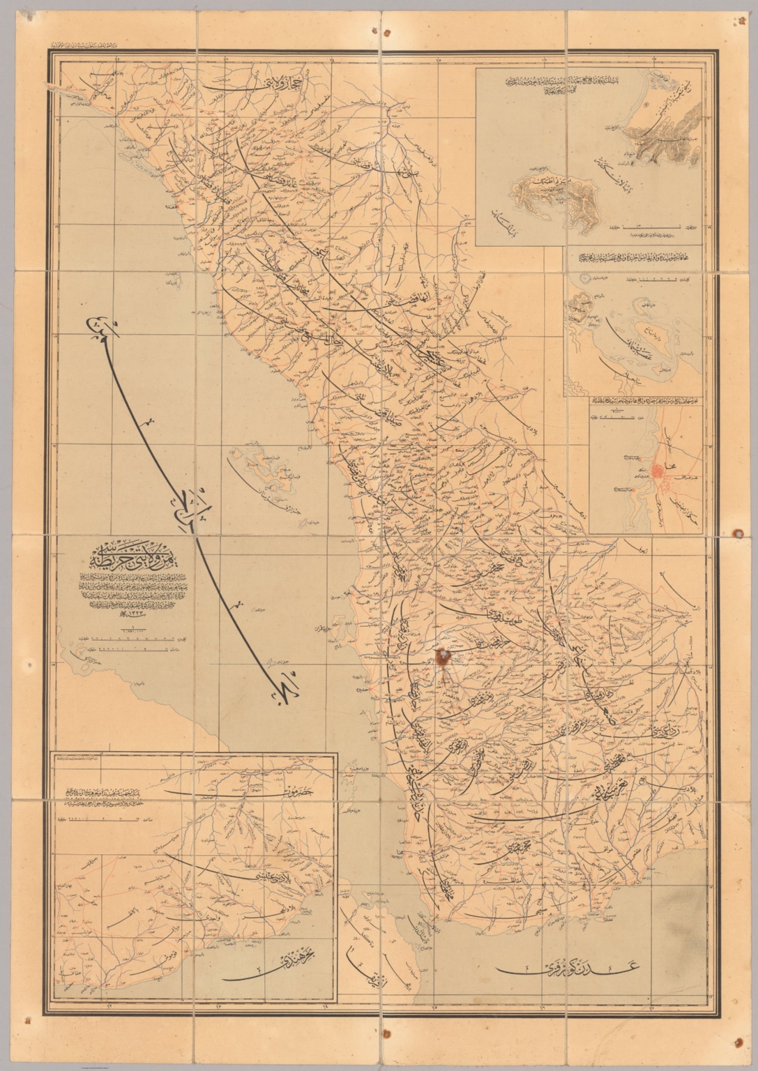
"Extremely rare - one of the two seminal printed Ottoman maps of Yemen, with the Asir, Jizan and Al Bahah areas of today’s Saudi Arabia, being the first scientific map of the region, predicated advanced surveys made by Ottoman Army Engineers completed during the Zaidi Rebellion (1904-11) in Yemen and the Idrisid Rebellion (1906-10) in Asir, which led large Ottoman army expeditions to traverse the interior; issued in Istanbul for the Ottoman War Ministry; its unprecedented degree of accuracy and high level of detail made it the apogee of the Ottoman mapping of Yemen and Asir, and it remained the authoritative operational and strategic guide for region until World War II. This extremely rare and important map represents the apogee of the Ottoman cartography of Yemen, and the regions of Asir, Jizan and Al Bahah (today part of Saudi Arabia), then de jure parts of the Ottoman Empire, but which were de facto largely under the control of various local potentates. It is the result of over a decade of surveys conducted by Ottoman Military Engineers, principally of its Fifth Drafting Department of the General Military Office (an elite surveying and reconnaissance unit), working under unimaginably difficult conditions, in the run up to and during the period when the greater region was inflamed by unrest, in the form of the Zaidi Rebellion (1904-11) in Yemen and the Idrisid Rebellion (1906-10) in Asir. Creating the map was a priority for the Ottomans, as a stellar knowledge of the forbidding interior was necessary for them to have any chance of combatting what were determined and skillfully led guerrilla insurgencies. The map is predicated upon trigonometrical survey of the major settled areas and transportation corridors, anchored basepoints determined by astronomical observations, making it the first scientific and planimetrically accurate map of Yemen and Asir, etc. The large-format, separately issued map was lithographed in 1907, in Istanbul, for the Erkan-ı Harbiye Umumiye (Ottoman War Ministry). The main map embraces all of Ottoman Yemen (North Yemen), the western part of the British Protectorate of Aden (South Yemen), while in the north the map extends as far as Al-Lith, in the Mecca region, so embracing of Asir, Jizan and Al Bahah. The coastlines are detailed with scientific precision, with all major rivers are depicted. Every city and town of any note is labelled, all fortis are marked, while the intricate network of roads and caravan routes, with the high roads emphasized, is portrayed in unprecedented detail, providing all the information needed to guide military movement. The map is augmented by four insets, with the one in the lower left corner depicting the Hadramawt (the western part of the Protectorate of Yemen); with in the upper right are the insets of the famed coffee port of Mocha (lower); Assab (centre, the port in Italian of Eritrea, just across the Red Sea from Yemen, which was of great strategic interest the Ottomans, as only four years later they would be at war with Italy); and, finally, a map of the Bab-el-Mandeb (top, the ‘Gate of Tears), marking the entrance to the Red Sea, with the strategically-placed British naval station of Perim Island and the adjacent mainland point of Ras Sheikh Said, home to a key ottoman fort, near the boundary between Ottoman and British Yemen. The present work is one of the two seminal Ottoman printed maps of Yemen and Asir, etc. It is the successor map of the first broadly accurate map of the region, Colonel Ahmed Muhtar’s Yemen Vilâyeti haritasi... (The Ottoman Vilayet of Yemen…) (Istanbul: Erkan-ı Harbiye Umumiye Matbaası, 1304 [1888]), a colossal composition (measuring 113 x 245 cm), that while an incredible accomplishment, being far more detailed than the present work, was nevertheless only semi-scientific, so was markedly less planimetrically accurate. One problem with the earlier map was that it was so large and heavy that it was far from ideal for field use and, as such, it had very limited operational applicability. Prior the creation of the 1888 map, the interior of Yemen and Asir, etc. was scarcely known to outsiders, and had never been charted in any serious sense due to the perceived hostility of the locals and the incredibly rugged, sunbaked nature of the landscape, although the coastlines had long been scientifically surveyed by the British Royal Navy. The present map, while still of a large format, could easily be carried by soldiers on horseback and consulted in the mountains and deserts during active campaigning. Its high accuracy, and fine level of detail rendered it a vital tool for operational planning, guiding military movement along the caravan routes towards bases and expected siege points. Like its predecessors, its relatively large scale would have allowed generals at headquarters, or those at the Sultan’s court in Istanbul, to consult the map for strategic planning (i.e., where to allocate resources in a general sense). As things turned out, the Ottomans would end up losing control over Asir in 1910 (the Idrisids having been successful in their revolt), while in Yemen they fought the Zaidis to a stalemate, resulting in the Sultan granting them effective local autonomy. However, the present work would remain by far and away the most accurate and authoritative map of the region (save for South Yemen, which was scientifically surveyed by the British) until the region was exactingly mapped during World War II. A Note on Rarity The present map is extremely rare. An expensive and informationally sensitive work, it would have been published in only a small print run, exclusively for use by senior Ottoman officers and politicians, while the survival rate of such large maps destined for active war zones is very low. We can locate only a single institutional example of the map, held by the University of Istanbul Library. Beyond that, we are aware of only 2 other examples of the map as having appeared on the market, being an example offered 3 years ago by a London dealer, as well as a record from an Istanbul auction. A Brief History of Ottoman Yemen & the Yemeni, or Zaidi, Rebellion of 1904-11 Yemen is one of the most ancient and culturally rich lands in the Middle East. It was traditionally also the source of great wealth; its interior produced coffee and silver, while its coastal ports were for millennia great marts of trade. Its strategic location often ensured that control of Yemen led to naval dominance of the Red Sea, a vital maritime link between South and East Asia and Europe. Yemen has also been closely associated with the regions of Asir, Jizan and Al Bahah (today in Saudi Arabia), located immediately to the north. At times these areas were parts of the political entity of Yemen, although they had their own distinct cultural identities. Asir was a valuable territory, as its relatively well-watered highlands were the most productive agricultural area in the entire Arabian Peninsula, capable of producing large yields of grains and fruits. Importantly, as in most many other parts of Arabia, practical power on a day to day basis was exercised by local tribal or village leaders, under the loose suzerainty of regional or imperial masters. Nobody ever comprehensively controlled Yemen and Asir on the ground, that was not the nature of region and its socities. For some generations up until the early 16th Century, much of Yemen and Asir was loosely ruled by the Mameluke Sultanate, which was based in Cairo. After the Ottomans vanquished the Mamelukes in 1517, a power vacuum ensued in Southern Arabia, leading to intense conflict between local powers. The Zaidi Imams were a dynasty led by scholar-warriors who representing a large Shia community in the Yemeni highlands, based in the great city of Sana’a. They were the leading power in the region, although their position was contested by local rivals. Meanwhile, The Ottomans secured Hejaz, with the holy cities of Mecca and Medina, which allowed the Ottoman Sultan to possess the title of Caliph, the defender of Islam. In 1538, the Zaidi Imamate, seeking protection from their regional rivals, invited the Ottoman army to come to Yemen, and to make the region a de jure part of the Ottoman Empire, while permitting the imam to maintain his internal autonomy. The Ottomans established the Eyelet of Yemen, and proceeded to extend their control along the tihama, while keeping a small garrison in Sana’a. For some decades, the Ottoman presence succeeded in buttressing the Zaidi regime, although the Sublime Porte’s authority over much of the country outside of main centres was weak. It is important to note that the Ottomans and the Zaidis were not natural allies; their outlooks differed greatly, starting with their conflicting Sunni-Shia theological identities. From the eyelet’s capital, the port of Mocha, the Ottomans derived considerable revenue from trading in the region’s commodities and slaves, while their presence in Yemen anchored their control of the Red Sea. However, the Ottomans eventually faced effective resistance from communities in the interior. Notably, the Zaidi imam Qasim the Great (ruled 1597-1620), came to resent the Ottoman presence in his country. He expelled the Ottomans from Sana’a and mounted a brutally effective guerrilla war against them. This cause was carried on by his son, Muhammad, and the Ottomans withdrew from Yemen altogether in 1636. The Zaidis then proceeded to conquer almost all of Yemen and Asir, creating one of the Middle East’s largest and most prosperous states. During the 18th century, Zaidi rule over most of the Yemen and Asir gradually collapsed. While the imamate retained control of Sana’a and its vicinity, the country fragmented under into the rule of numerous local potentates. The Ottomans, facing crises in the Caucuses and Balkans, showed little interest the region. In 1805, the religiously arch-conservative Wahhabis sprang with shocking speed and force out of their homeland in the desserts of the Nejd to conquer the holy cities of Mecca and Medina. This was a catastrophe for the Sublime Porte, as the loss of the holy cities undermined the Sultans’ claim to the Caliphate, which was, in many cases, the only thing that legitimized his rule over non-Turkish Muslims. Muhammad Ali, the Ottoman Viceroy of Egypt, was tasked with regaining control of the holy cities in the name of the sultan. This was achieved in 1811, after which he meted out harsh justice upon the Wahhabis. Nevertheless, the, albeit temporary, loss of Mecca and left the Sublime Porte rattled. Meanwhile, the situation in Yemen and Asir remained quite unstable, with the lobal powers likewise shaken by the Wahhabi surge into nearby Hejaz (the Shai Zaidi Imams held a special antipathy towards the Wahabis). During the First Ottoman Egyptian War (1831-3), Muhammed Ali rebelled against Ottoman rule and successfully took over Egypt, the Levant and Hejaz. He also managed to extend his authority along the tihama of Azir and Yemen, although his influence there was never strong. The Viceroy’s forces almost caused the collapse of the Sublime Porte in Turkey, before being convinced to back down. The Egyptians agreed to recognize the Sultan as their overlord, but only in the most technical sense; much of the Middle East would be, for all practical purposes, ruled from Cairo. Meanwhile, Yemen’s strategic location, guarding the Bab-el-Mandeb, the nexus between the Red Sea and Indian Ocean, came to the forefront of global geopolitics. Britain was alarmed by Muhammed Ali’s expansion, fearing that it could threaten Britain’s all-important interests in the Indian Ocean. In 1839, they founded a naval base at Aden, a stellar natural harbour on the Indian Ocean coast of Yemen. Following the Second Egyptian–Ottoman War (1840-1), Britain pressured Muhammed Ali into backing down. He agreed to essentially become the head of an autonomous dynasty in Egypt and Sudan in return for restoring Ottoman rule over the Levant and Hejaz. Egyptian forces where withdrawn from the tihama of Asir and Yemen, creating a power vacuum that added to the region’s instability. Even as the Egyptian thereat had been neutralized, the Sublime Porte was concerned that the growing British presence around Aden and the instability in Yemen and Asir (which bordered the Mecca region) endangered their hold on the holy cities. While initially reluctant to mount what would be a technically difficult and expensive campaign, in the late 1840s, the Ottomans decided to reclaim Asir and Yemen to shore up the empire’s position in Hejaz and Red Sea. It must be noted that this new ‘proactive’ Ottoman policy must be seen within the greater context of the Tanzimat Era (1839-76), whereupon the Sublime Porte’s comprehensive regime of reforms, including the modernisation of the military and renewed impetus to re-assert central authority in the empire’s peripheral regions. By April 1849, Ottoman expeditionary forces had taken control of the tihama of both Asir and much of Yemen, including the key port of Hodeida. Echoing the situation three centuries earlier, in July 1839, the Zaidi Imam Mohammed Yayha invited the Ottomans to come to Sana’a, where he concluded an agreement under which Zaidi lands would become subject to the Sublime Porte, while then imamate retained its local autonomy. A small Ottoman garrison was established in Sana’a, while the Sublime Porte extended its control over the tihama southwards down to the Bab-el-Mandeb, so re-establishing the Eyelet of Yemen. Perhaps predictably, the Ottomans and the Zaidi imamate soon had a falling out and the Ottoman garrison was expelled from the Sana’a. Turkish authority completely dissolved beyond the tihama. The Ottomans, preoccupied with grand faraway events, such as the Crimean War and conflicts in the Balkans, were unable to re-establish their authority beyond their coastal garrisons. This was not only because of a lack of manpower, but also due to the fact that the Ottomans possessed very scant knowledge of the geography of the interior of Asir and Yemen; they usually relied upon local guides even to traverse the highroads. As the Yemeni tribesmen who contested Ottoman rule were masters a guerrilla warfare, without a detailed knowledge of the terrain, even a large Turkish army would be doomed to ambush and entrapment. While decent sea charts of the coasts existed, the existing mapping of the interior was so vague as to be operationally worthless. The opening of the Suez Canal, controlled by France and Britain, in 1869 posed a new threat to the Ottoman control of the Hejaz and their presence in Arabia. Hitherto the Red Sea would become one of the globe’s busiest shipping lanes, with routes controlled by foreign imperialist powers. The Royal Navy centre at Aden was to be majorly upgraded into one of the world’s largest naval bases, while the British would, in 1872, declare all south-eastern Yemen to be their Aden Protectorate. Moreover, France was directing covetous eyes towards Yemen’s magnificent coffee industry. The Sublime Porte knew that it had to act fast to prevent its authority in Arabia from slipping away. In 1869, a large and well-equipped Ottoman army under Colonel Ahmed Muhtar (1839 - 1919) was sent to conquer Asir and North and Western Yemen. Ahmed Muhtar was no ordinary army commander, but a polymath scientist, writer and diplomat who while barely thirty years old had already played a critical role in modernizing the Ottoman military. The most versatile and clever Ottoman soldier of his era, he had an uncanny ability to master different battle theatres and proved to be equally adept at both guerrilla warfare in remote mountains as well as set piece field battles. Importantly, Ahmed Muhtar was a professional military engineer who placed extraordinary value on geographic knowledge and cartography. He obsessively pressed his engineers and scouts to map the terrain, before integrating this information into regional maps of Yemen. In this way the Ottomans gained the first detailed and approximately accurate body of geographical knowledge of the interior of Asir and Yemen. In this incredibly mountainous region, the attainment of such knowledge was not merely a supporting factor, but rather a pivotal, determinative issue in the success of any military campaign. Ahmed Muhtar made short work of rebels in Asir, conquering much of the region by 1871. Moving south, he easily gained mastery of the tihama. Sultan Abdulaziz II was so impressed by his success, that Ahmed Muhtar was promoted to general and pasha and made the Vali (governor) of Yemen. In 1872, Ahmed Muhtar turned his sights on the real trouble spot, the Yemeni highlands. He managed to outwit many of the tribes that lay between the coast and Sana’a. This show of force convinced the Zaidi Imam Ghalib, whose regime suffered from internal cleavages, to invite the Ottomans to come to Sana’a to make a deal. Ahmed Muhtar arrived in Sana’a in April 1872, where he was greeted with great pomp and hospitality. The Zaidi imam agreed to accept the Sultan as his overlord in return for imperial protection and the maintenance of his local autonomy. However, it would later be revealed that Ahmed Muhtar and the Imam had very different interpretations of the meaning of the accord. Ahmed Muhtar attempted to set up a modern administration in Yemen in line with the Tanzimat programme. The country became a full Ottoman vilayet (province), and was divided into four sanjaks (districts), being Sana’a, Hodeida, Asir and Taiz. Civil servants were appointed from the local tribesmen to collect taxes and customs revenues, while significant funds (at least in part derived for the local taxes) were earmarked for infrastructure development and social programs. Army units were also raised from the local population, giving steady employment to otherwise listless young men. In the key cities and some rural areas, the local people from tribal chiefs all the way on down to common peasants came to depend on the Ottoman state for their livelihoods (which was part of the Ottoman design). On the other hand, some tribes, especially those who were traditionally at odds with the Ottomans’ ‘friends’ the Zaidi Imams, continued to mount small scale rebellions across the Yemeni highlands. While these problems were kept in check, it was at a high cost, as 4,000 Ottoman troops died in Yemen between 1872 and 1875. Nevertheless, by the time Ahmed Muhtar Pasha left Yemen in September 1874, to assume his promotion as the Ottoman Minister of Public Works, he had largely succeeded in ensuring that Yemen had become an integrated part of the Ottoman Empire in the modern sense, something that nobody else would ever achieve. During the 1880s, the Ottoman Treasury was desperately short of funds owing to a public debt crisis and enacted harsh budgetary cutbacks. The empire no longer had money to give financial ‘incentives’ to Yemeni tribal leaders; many native civil servants were not paid regularly; and local army detachments were disbanded. To the Yemenis the Ottomans were no longer holding up their end of the bargain, and unrest and mini-rebellions broke out across the Yemeni highlands. The Ottomans lost control of virtually all areas to the north and east of Sana’a. It also did not help that British agents were soliciting the tribes in the far south, near Taiz, to join the Aden Protectorate. The Ottoman army soon found itself constantly moving about the country ‘putting out fires’, fighting a seemingly endless struggle to regain control. However, the constant military movement and the need to repair infrastructure, gave the Ottoman military engineers, particularly of the Fifth Drafting Department of the General Military Office, the opportunity to conduct the first scientific surveys of the interior of Yemen, leading to the creation of the present map. The Zaidi Imamate, hitherto the bedrock of the Ottoman regime in Yemeni highlands contemplated switching sides. The Zaidis never liked Ahmed Muhtar’s modernizing programme; they felt that creating a ‘modern’ Yemen violated their autonomy and traditions. As Shiites they also came to find many of the religious practices of the mainly Sunni Ottoman forces to be disagreeable. The Zaidi feigned a rebellion in 1891, before calling it off; however, the bloom was off the rose and relations between Constantinople and Sana’a continued to deteriorate. In 1904, the new Zaid Imam Yahya Muhammad Hamid ed-Din, or simply Imam Yahya (1869 – 1948) mounted a full-scale rebellion against Ottoman rule. A highly intelligent and discipled leader, his guerrilla tactics outmatched the Sultan’s overstretched forces and the Ottomans were virtually driven out of the Yemeni highlands. After years of hard fighting wore down both parties, the Imam and the Sublime Porte signed the Treaty of Da’an (1911), which settled matters largely on the Zaidi terms; essentially the Zaidis would rule much of Ottoman Yemen, with only very light Ottoman oversight. Meanwhile, the Ottomans were also having trouble in Asir, as beginning in 1906 the local leader Muhammad ibn Ali al-Idrisi rebelled against the Sublime Porte. The Idrisids succeeding in driving the Ottomans out of much of Asir and Jizan by 1910, forming the Idrisid Emirate of Asir. The Idrisids were enemies of the Zaidis, so the new reality in Yemen was very tense. Yemen was a key theatre in World War I, with the Zaidis supporting the Ottomans, while the British backed the Idrisids. The Ottoman Empire collapsed upon the end of the conflict in 1918, whereupon Imam Yayha declared himself ruler of the Mutawakkilite Kingdom of Yemen, forming a regime that would persist until 1962 (after which the country became the Yen Arab Republic, popularly known as North Yemen). After fighting an exhausting war against the Zaidis., the Idrisids lands were absorbed into Saudi Arabia in 1934. The British continued to rule their Aden Protectorate until 1967, after which point the country became the People’s Democratic Republic of Yemen, popularly known as South Yemen. North Yemen and South Yemen were unified in 1990. Sadly, however, since 2015, Yemen’s old rivalries have retuned to fore, upon the outbreak of the ongoing Yemeni Civil War." (Alexander Johnson and Dasa Pahor, 2023), University of Istanbul Library: IUNEK93843; Cf. (Background:) Robert T.O. WILSON, Gazetteer of Historical North-West Yemen in the Islamic Period to 1650 (1989), p. 353; Abdol Rauh YACCOB, ‘Yemeni opposition to Ottoman rule: an overview’, Proceedings of the Seminar for Arabian Studies, vol. 42, [Papers from the forty-fifth meeting of the Seminar for Arabian Studies held at the British Museum, London, 28to 30 July 2011] (2012), pp. 411-419. Not in: Osmanlı coğrafya literatürü tarihi. History of Geographical Literature during the Ottoman Period, 2000.

Bey, Abdürrahim Hilmi and Anonymous
"This is an extraordinary privately assembled encyclopaedia, focused on Mecca as the Navel of the World. Written in manuscript in thin black and red pens in Ottoman language, it contains over 580 pages of manuscript in tiny characters, sometimes accompanied with charts, over 380 manuscript maps, made with extreme care in precision in colours and with gold and silver highlights, over 225 prints from magazines, books, atlases and other sources from the late 19th and early 20th centuries, often joined in collages and compositions with hand-drawn maps. The maps are made with a greatest precision in well planned configuration. The colours are carefully applied to give an instant effect of a modern data visualisation. The gilt highlights and small details in black ink express the author’s endless patience and dedication to the project. The manuscripts, maps and illustrations are tastefully and carefully joined together thematically in foldouts and pamphlets, bound together with linen or paper stripes or strings. Shorter subjects and uncut plates also appear as separate leaves. We could count 217 such separate units. The whole collection is housed in three charming boxes, possibly made by the author from commercial boxes and leftovers of the linen, which he used for drawings of some of the maps. The anonymous author, doubtless a Muslim intellectual, took the information from the contemporary sources and atlases and smartly combined them in his own unique compositions. He also often added his own annotations, colouring and keys to the prints, which he took from the books and magazines. The manuscripts give an impression of a coherent collection, which was probably never meant for a publication. It was possibly an author private project, to which he dedicated years or decades of his life. It is possible that the collection was meant for a private education. Focus on Mecca The maps with geographic, historic and thematic data focus on the Arabian Peninsula with Mecca as a center. Throughout the series the city is often smartly positioned in the middle of the folds, to give the impression, that the world and around it opens like a flower. In the collection we could trace approximately 23 maps, where Mecca is represented in the central point of the world, 24 maps showcasing only the Arabian Peninsula or parts of it or / and the Red Sea, circa 25 maps of Mecca or/and its surroundings and sketches of the Kaaba and 11 views and prints of Mecca. The latter ones have been taken from other publications and integrated into the encyclopaedia by the author. Medina is represented with two manuscript maps and 8 views. The views here are as well taken from other publications. Separate pamphlets also focus on the history of the Arabian Peninsula and the history of its inhabitants with a chart on the tribes of Arabia. With this work the author geographically represented Mecca as the central point, a navel of the global culture and history from the ancient times up to the present days. Other Subjects The pamphlets and fold-outs are bound together thematically and represent the cultures, history and geography of the World from its beginnings until the early 20th century. The manuscript units with maps, charts and illustrations describe subjects such as geology, time through the Ottoman time charts, astronomy and astrology, ancient cultures and monuments (Babylon, Mesopotamia, Ancient Greece, Baalbek etc.), old geographic representations, such as Tabula Peutingeriana and parts of Fra Mauro’s map, America on old maps, discoveries on America and later discoveries and explorations, thematic maps of the world and parts of the world etc. A large portion of the maps is dedicated to the Mediterranean Basement (ca 152 maps) and the Balkans, with the large Ottoman battles. The other maps focus on Asia, America (ca 5 maps of North America, 2 maps of Central America), other continents and the whole world (27 maps of the world). The author seems unattached an ambivalent to Istanbul and Turkey, as the region is almost neglected in the manuscripts, which is the opposite of the contemporary glorification of the newly founded Turkey and the magnificent history of Istanbul. Also hardly represented are the African regions, including the Muslim ones. It is possible, that the author spent most of his life on the Arabian Peninsula and was not attached to the cultural and political center Istanbul. Authorship and Date The author of the work is not signed, neither are the maps dated. According to the attached note, the collection was allegedly connected with the family of the Turkish writer Ahmed Cemil Akıncı (1914-1984). His father and a possible author, Abdürrahim Hilmi Bey (Sipahizâde) was of Sipahi origins from Rumelia and was educated at the Fatih Madrasa in Istanbul. Hilmi Bey was in charge for the railway and education in Egypt, Palestine, Syria and Hejaz, where he spent a large part of his life. This would explain the author’s unattachment to Istanbul and Turkey. The paper, style and material of the boxes indicate the late 1910s and 1920s. Some of the maps confirm this period of time: a series of thematic world maps (possibly drafted after a contemporary Ottoman atlas) showcase the world in 1915 (1331 Rumi years). An illustration from a magazine, representing a map A Child’s Map of the Ancient World, by Alice York and Ilonka Karasz, was published in 1926. It is the youngest dated document, which we could trace in the collection. References: Unrecorded. [S. l., s. d. Possibly Ottoman Empire / Turkey, late 1910s-1920s]. A magnificent hand-written privately assembled encyclopaedia of the World, affectionately assembled and curated by an enlightened Muslim scholar in the last years of the Ottoman Empire, with over 580 text pages and 380 hand drawn detailed maps with gilt highlights, represents Mecca as the Navel of the World and the connecting point between the ancient civilisations and culture and the modern East and West. Collation: 3 red privately custom-made boxes, constructed of thick card with red linen surface with debossed lettering and decoration, patterned paper mounted inside, each with a black cloth loop with a knot, edges originally reinforced with linen, some linen parts with details of manuscript maps, 9 x 14 x 20 cm (3.5 x 5.5 x 7.8 inches). The boxes contain: - 217 separate units of fold-outs (leporellos), pamphlets and maps composed of sheets of paper, privately joined with straps of linen, sporadically also with stripes of paper or bound together with a sting. Most units with 4-8 pp., but also single sheet units and pamphlets with up to 16 pp. manuscript text. Most of the text accompanied with manuscript maps, mostly mounted verso. Some manuscript maps on loose linen waxed paper. Also includes sporadic single prints from books and magazines and postcards, not edited by the author. - The 217 units include: - - Over 580 manuscript text pages, some with charts in text, plus additional text comments and keys. Black and red ink on paper of various quality and thick card, each 18 x 11,5 cm (7 x 4.5 inches) when folded. - - More than 380 manuscript maps, including multiple maps on one sheet and folding maps. The maps are mostly mounted or drawn on cards on the inner side of the fold-outs and pamphlets, on the back of the text sheets. Some manuscript maps on loose waxed linen paper sheets. Most of the maps are ornated with gilt highlights. Black, purple and red ink and water colours on paper and linen paper, from 18 x 11,5 cm to 18 x 44 cm (7 x 4.5 inches to 7 x 17.3 inches), mostly mounted on the back of text pages, but also loose sheets. - - More than 225 prints, mostly mounted in compositions with maps, pictorial panels and more than 35 collages. The prints of various, mostly small sizes include maps, lithographs, chromolithographs, steel engravings, wood-cuts, postcards (cut and uncut), photo-reproductions, illustrations from books and magazines etc. Some prints (mostly illustrations from books and postcards) are added as unedited and uncut sheets. The prints have been taken from mostly Ottoman, but also German, French and English publications. Various techniques, some with manuscript annotations in black ink or with hand colour. - Additional unsorted sheets of manuscript and illustrations. Condition report: Boxes with some staining and minor wear on the edges, manuscripts and maps overall in a good clean condition with minor staining, foxing and wear. Sporadic maps and manuscripts are left unfinished." (Alexander Johnson and Dasa Pahor, 2020)

Anonymous and Bey, Abdürrahim Hilmi
"This is an extraordinary privately assembled encyclopaedia, focused on Mecca as the Navel of the World. Written in manuscript in thin black and red pens in Ottoman language, it contains over 580 pages of manuscript in tiny characters, sometimes accompanied with charts, over 380 manuscript maps, made with extreme care in precision in colours and with gold and silver highlights, over 225 prints from magazines, books, atlases and other sources from the late 19th and early 20th centuries, often joined in collages and compositions with hand-drawn maps. The maps are made with a greatest precision in well planned configuration. The colours are carefully applied to give an instant effect of a modern data visualisation. The gilt highlights and small details in black ink express the author’s endless patience and dedication to the project. The manuscripts, maps and illustrations are tastefully and carefully joined together thematically in foldouts and pamphlets, bound together with linen or paper stripes or strings. Shorter subjects and uncut plates also appear as separate leaves. We could count 217 such separate units. The whole collection is housed in three charming boxes, possibly made by the author from commercial boxes and leftovers of the linen, which he used for drawings of some of the maps. The anonymous author, doubtless a Muslim intellectual, took the information from the contemporary sources and atlases and smartly combined them in his own unique compositions. He also often added his own annotations, colouring and keys to the prints, which he took from the books and magazines. The manuscripts give an impression of a coherent collection, which was probably never meant for a publication. It was possibly an author private project, to which he dedicated years or decades of his life. It is possible that the collection was meant for a private education. Focus on Mecca The maps with geographic, historic and thematic data focus on the Arabian Peninsula with Mecca as a center. Throughout the series the city is often smartly positioned in the middle of the folds, to give the impression, that the world and around it opens like a flower. In the collection we could trace approximately 23 maps, where Mecca is represented in the central point of the world, 24 maps showcasing only the Arabian Peninsula or parts of it or / and the Red Sea, circa 25 maps of Mecca or/and its surroundings and sketches of the Kaaba and 11 views and prints of Mecca. The latter ones have been taken from other publications and integrated into the encyclopaedia by the author. Medina is represented with two manuscript maps and 8 views. The views here are as well taken from other publications. Separate pamphlets also focus on the history of the Arabian Peninsula and the history of its inhabitants with a chart on the tribes of Arabia. With this work the author geographically represented Mecca as the central point, a navel of the global culture and history from the ancient times up to the present days. Other Subjects The pamphlets and fold-outs are bound together thematically and represent the cultures, history and geography of the World from its beginnings until the early 20th century. The manuscript units with maps, charts and illustrations describe subjects such as geology, time through the Ottoman time charts, astronomy and astrology, ancient cultures and monuments (Babylon, Mesopotamia, Ancient Greece, Baalbek etc.), old geographic representations, such as Tabula Peutingeriana and parts of Fra Mauro’s map, America on old maps, discoveries on America and later discoveries and explorations, thematic maps of the world and parts of the world etc. A large portion of the maps is dedicated to the Mediterranean Basement (ca 152 maps) and the Balkans, with the large Ottoman battles. The other maps focus on Asia, America (ca 5 maps of North America, 2 maps of Central America), other continents and the whole world (27 maps of the world). The author seems unattached an ambivalent to Istanbul and Turkey, as the region is almost neglected in the manuscripts, which is the opposite of the contemporary glorification of the newly founded Turkey and the magnificent history of Istanbul. Also hardly represented are the African regions, including the Muslim ones. It is possible, that the author spent most of his life on the Arabian Peninsula and was not attached to the cultural and political center Istanbul. Authorship and Date The author of the work is not signed, neither are the maps dated. According to the attached note, the collection was allegedly connected with the family of the Turkish writer Ahmed Cemil Akıncı (1914-1984). His father and a possible author, Abdürrahim Hilmi Bey (Sipahizâde) was of Sipahi origins from Rumelia and was educated at the Fatih Madrasa in Istanbul. Hilmi Bey was in charge for the railway and education in Egypt, Palestine, Syria and Hejaz, where he spent a large part of his life. This would explain the author’s unattachment to Istanbul and Turkey. The paper, style and material of the boxes indicate the late 1910s and 1920s. Some of the maps confirm this period of time: a series of thematic world maps (possibly drafted after a contemporary Ottoman atlas) showcase the world in 1915 (1331 Rumi years). An illustration from a magazine, representing a map A Child’s Map of the Ancient World, by Alice York and Ilonka Karasz, was published in 1926. It is the youngest dated document, which we could trace in the collection. References: Unrecorded. [S. l., s. d. Possibly Ottoman Empire / Turkey, late 1910s-1920s]. A magnificent hand-written privately assembled encyclopaedia of the World, affectionately assembled and curated by an enlightened Muslim scholar in the last years of the Ottoman Empire, with over 580 text pages and 380 hand drawn detailed maps with gilt highlights, represents Mecca as the Navel of the World and the connecting point between the ancient civilisations and culture and the modern East and West. Collation: 3 red privately custom-made boxes, constructed of thick card with red linen surface with debossed lettering and decoration, patterned paper mounted inside, each with a black cloth loop with a knot, edges originally reinforced with linen, some linen parts with details of manuscript maps, 9 x 14 x 20 cm (3.5 x 5.5 x 7.8 inches). The boxes contain: - 217 separate units of fold-outs (leporellos), pamphlets and maps composed of sheets of paper, privately joined with straps of linen, sporadically also with stripes of paper or bound together with a sting. Most units with 4-8 pp., but also single sheet units and pamphlets with up to 16 pp. manuscript text. Most of the text accompanied with manuscript maps, mostly mounted verso. Some manuscript maps on loose linen waxed paper. Also includes sporadic single prints from books and magazines and postcards, not edited by the author. - The 217 units include: - - Over 580 manuscript text pages, some with charts in text, plus additional text comments and keys. Black and red ink on paper of various quality and thick card, each 18 x 11,5 cm (7 x 4.5 inches) when folded. - - More than 380 manuscript maps, including multiple maps on one sheet and folding maps. The maps are mostly mounted or drawn on cards on the inner side of the fold-outs and pamphlets, on the back of the text sheets. Some manuscript maps on loose waxed linen paper sheets. Most of the maps are ornated with gilt highlights. Black, purple and red ink and water colours on paper and linen paper, from 18 x 11,5 cm to 18 x 44 cm (7 x 4.5 inches to 7 x 17.3 inches), mostly mounted on the back of text pages, but also loose sheets. - - More than 225 prints, mostly mounted in compositions with maps, pictorial panels and more than 35 collages. The prints of various, mostly small sizes include maps, lithographs, chromolithographs, steel engravings, wood-cuts, postcards (cut and uncut), photo-reproductions, illustrations from books and magazines etc. Some prints (mostly illustrations from books and postcards) are added as unedited and uncut sheets. The prints have been taken from mostly Ottoman, but also German, French and English publications. Various techniques, some with manuscript annotations in black ink or with hand colour. - Additional unsorted sheets of manuscript and illustrations. Condition report: Boxes with some staining and minor wear on the edges, manuscripts and maps overall in a good clean condition with minor staining, foxing and wear. Sporadic maps and manuscripts are left unfinished." (Alexander Johnson and Dasa Pahor, 2020)

Bey, Abdürrahim Hilmi and Anonymous
"This is an extraordinary privately assembled encyclopaedia, focused on Mecca as the Navel of the World. Written in manuscript in thin black and red pens in Ottoman language, it contains over 580 pages of manuscript in tiny characters, sometimes accompanied with charts, over 380 manuscript maps, made with extreme care in precision in colours and with gold and silver highlights, over 225 prints from magazines, books, atlases and other sources from the late 19th and early 20th centuries, often joined in collages and compositions with hand-drawn maps. The maps are made with a greatest precision in well planned configuration. The colours are carefully applied to give an instant effect of a modern data visualisation. The gilt highlights and small details in black ink express the author’s endless patience and dedication to the project. The manuscripts, maps and illustrations are tastefully and carefully joined together thematically in foldouts and pamphlets, bound together with linen or paper stripes or strings. Shorter subjects and uncut plates also appear as separate leaves. We could count 217 such separate units. The whole collection is housed in three charming boxes, possibly made by the author from commercial boxes and leftovers of the linen, which he used for drawings of some of the maps. The anonymous author, doubtless a Muslim intellectual, took the information from the contemporary sources and atlases and smartly combined them in his own unique compositions. He also often added his own annotations, colouring and keys to the prints, which he took from the books and magazines. The manuscripts give an impression of a coherent collection, which was probably never meant for a publication. It was possibly an author private project, to which he dedicated years or decades of his life. It is possible that the collection was meant for a private education. Focus on Mecca The maps with geographic, historic and thematic data focus on the Arabian Peninsula with Mecca as a center. Throughout the series the city is often smartly positioned in the middle of the folds, to give the impression, that the world and around it opens like a flower. In the collection we could trace approximately 23 maps, where Mecca is represented in the central point of the world, 24 maps showcasing only the Arabian Peninsula or parts of it or / and the Red Sea, circa 25 maps of Mecca or/and its surroundings and sketches of the Kaaba and 11 views and prints of Mecca. The latter ones have been taken from other publications and integrated into the encyclopaedia by the author. Medina is represented with two manuscript maps and 8 views. The views here are as well taken from other publications. Separate pamphlets also focus on the history of the Arabian Peninsula and the history of its inhabitants with a chart on the tribes of Arabia. With this work the author geographically represented Mecca as the central point, a navel of the global culture and history from the ancient times up to the present days. Other Subjects The pamphlets and fold-outs are bound together thematically and represent the cultures, history and geography of the World from its beginnings until the early 20th century. The manuscript units with maps, charts and illustrations describe subjects such as geology, time through the Ottoman time charts, astronomy and astrology, ancient cultures and monuments (Babylon, Mesopotamia, Ancient Greece, Baalbek etc.), old geographic representations, such as Tabula Peutingeriana and parts of Fra Mauro’s map, America on old maps, discoveries on America and later discoveries and explorations, thematic maps of the world and parts of the world etc. A large portion of the maps is dedicated to the Mediterranean Basement (ca 152 maps) and the Balkans, with the large Ottoman battles. The other maps focus on Asia, America (ca 5 maps of North America, 2 maps of Central America), other continents and the whole world (27 maps of the world). The author seems unattached an ambivalent to Istanbul and Turkey, as the region is almost neglected in the manuscripts, which is the opposite of the contemporary glorification of the newly founded Turkey and the magnificent history of Istanbul. Also hardly represented are the African regions, including the Muslim ones. It is possible, that the author spent most of his life on the Arabian Peninsula and was not attached to the cultural and political center Istanbul. Authorship and Date The author of the work is not signed, neither are the maps dated. According to the attached note, the collection was allegedly connected with the family of the Turkish writer Ahmed Cemil Akıncı (1914-1984). His father and a possible author, Abdürrahim Hilmi Bey (Sipahizâde) was of Sipahi origins from Rumelia and was educated at the Fatih Madrasa in Istanbul. Hilmi Bey was in charge for the railway and education in Egypt, Palestine, Syria and Hejaz, where he spent a large part of his life. This would explain the author’s unattachment to Istanbul and Turkey. The paper, style and material of the boxes indicate the late 1910s and 1920s. Some of the maps confirm this period of time: a series of thematic world maps (possibly drafted after a contemporary Ottoman atlas) showcase the world in 1915 (1331 Rumi years). An illustration from a magazine, representing a map A Child’s Map of the Ancient World, by Alice York and Ilonka Karasz, was published in 1926. It is the youngest dated document, which we could trace in the collection. References: Unrecorded. [S. l., s. d. Possibly Ottoman Empire / Turkey, late 1910s-1920s]. A magnificent hand-written privately assembled encyclopaedia of the World, affectionately assembled and curated by an enlightened Muslim scholar in the last years of the Ottoman Empire, with over 580 text pages and 380 hand drawn detailed maps with gilt highlights, represents Mecca as the Navel of the World and the connecting point between the ancient civilisations and culture and the modern East and West. Collation: 3 red privately custom-made boxes, constructed of thick card with red linen surface with debossed lettering and decoration, patterned paper mounted inside, each with a black cloth loop with a knot, edges originally reinforced with linen, some linen parts with details of manuscript maps, 9 x 14 x 20 cm (3.5 x 5.5 x 7.8 inches). The boxes contain: - 217 separate units of fold-outs (leporellos), pamphlets and maps composed of sheets of paper, privately joined with straps of linen, sporadically also with stripes of paper or bound together with a sting. Most units with 4-8 pp., but also single sheet units and pamphlets with up to 16 pp. manuscript text. Most of the text accompanied with manuscript maps, mostly mounted verso. Some manuscript maps on loose linen waxed paper. Also includes sporadic single prints from books and magazines and postcards, not edited by the author. - The 217 units include: - - Over 580 manuscript text pages, some with charts in text, plus additional text comments and keys. Black and red ink on paper of various quality and thick card, each 18 x 11,5 cm (7 x 4.5 inches) when folded. - - More than 380 manuscript maps, including multiple maps on one sheet and folding maps. The maps are mostly mounted or drawn on cards on the inner side of the fold-outs and pamphlets, on the back of the text sheets. Some manuscript maps on loose waxed linen paper sheets. Most of the maps are ornated with gilt highlights. Black, purple and red ink and water colours on paper and linen paper, from 18 x 11,5 cm to 18 x 44 cm (7 x 4.5 inches to 7 x 17.3 inches), mostly mounted on the back of text pages, but also loose sheets. - - More than 225 prints, mostly mounted in compositions with maps, pictorial panels and more than 35 collages. The prints of various, mostly small sizes include maps, lithographs, chromolithographs, steel engravings, wood-cuts, postcards (cut and uncut), photo-reproductions, illustrations from books and magazines etc. Some prints (mostly illustrations from books and postcards) are added as unedited and uncut sheets. The prints have been taken from mostly Ottoman, but also German, French and English publications. Various techniques, some with manuscript annotations in black ink or with hand colour. - Additional unsorted sheets of manuscript and illustrations. Condition report: Boxes with some staining and minor wear on the edges, manuscripts and maps overall in a good clean condition with minor staining, foxing and wear. Sporadic maps and manuscripts are left unfinished." (Alexander Johnson and Dasa Pahor, 2020)

Anonymous and Bey, Abdürrahim Hilmi
"This is an extraordinary privately assembled encyclopaedia, focused on Mecca as the Navel of the World. Written in manuscript in thin black and red pens in Ottoman language, it contains over 580 pages of manuscript in tiny characters, sometimes accompanied with charts, over 380 manuscript maps, made with extreme care in precision in colours and with gold and silver highlights, over 225 prints from magazines, books, atlases and other sources from the late 19th and early 20th centuries, often joined in collages and compositions with hand-drawn maps. The maps are made with a greatest precision in well planned configuration. The colours are carefully applied to give an instant effect of a modern data visualisation. The gilt highlights and small details in black ink express the author’s endless patience and dedication to the project. The manuscripts, maps and illustrations are tastefully and carefully joined together thematically in foldouts and pamphlets, bound together with linen or paper stripes or strings. Shorter subjects and uncut plates also appear as separate leaves. We could count 217 such separate units. The whole collection is housed in three charming boxes, possibly made by the author from commercial boxes and leftovers of the linen, which he used for drawings of some of the maps. The anonymous author, doubtless a Muslim intellectual, took the information from the contemporary sources and atlases and smartly combined them in his own unique compositions. He also often added his own annotations, colouring and keys to the prints, which he took from the books and magazines. The manuscripts give an impression of a coherent collection, which was probably never meant for a publication. It was possibly an author private project, to which he dedicated years or decades of his life. It is possible that the collection was meant for a private education. Focus on Mecca The maps with geographic, historic and thematic data focus on the Arabian Peninsula with Mecca as a center. Throughout the series the city is often smartly positioned in the middle of the folds, to give the impression, that the world and around it opens like a flower. In the collection we could trace approximately 23 maps, where Mecca is represented in the central point of the world, 24 maps showcasing only the Arabian Peninsula or parts of it or / and the Red Sea, circa 25 maps of Mecca or/and its surroundings and sketches of the Kaaba and 11 views and prints of Mecca. The latter ones have been taken from other publications and integrated into the encyclopaedia by the author. Medina is represented with two manuscript maps and 8 views. The views here are as well taken from other publications. Separate pamphlets also focus on the history of the Arabian Peninsula and the history of its inhabitants with a chart on the tribes of Arabia. With this work the author geographically represented Mecca as the central point, a navel of the global culture and history from the ancient times up to the present days. Other Subjects The pamphlets and fold-outs are bound together thematically and represent the cultures, history and geography of the World from its beginnings until the early 20th century. The manuscript units with maps, charts and illustrations describe subjects such as geology, time through the Ottoman time charts, astronomy and astrology, ancient cultures and monuments (Babylon, Mesopotamia, Ancient Greece, Baalbek etc.), old geographic representations, such as Tabula Peutingeriana and parts of Fra Mauro’s map, America on old maps, discoveries on America and later discoveries and explorations, thematic maps of the world and parts of the world etc. A large portion of the maps is dedicated to the Mediterranean Basement (ca 152 maps) and the Balkans, with the large Ottoman battles. The other maps focus on Asia, America (ca 5 maps of North America, 2 maps of Central America), other continents and the whole world (27 maps of the world). The author seems unattached an ambivalent to Istanbul and Turkey, as the region is almost neglected in the manuscripts, which is the opposite of the contemporary glorification of the newly founded Turkey and the magnificent history of Istanbul. Also hardly represented are the African regions, including the Muslim ones. It is possible, that the author spent most of his life on the Arabian Peninsula and was not attached to the cultural and political center Istanbul. Authorship and Date The author of the work is not signed, neither are the maps dated. According to the attached note, the collection was allegedly connected with the family of the Turkish writer Ahmed Cemil Akıncı (1914-1984). His father and a possible author, Abdürrahim Hilmi Bey (Sipahizâde) was of Sipahi origins from Rumelia and was educated at the Fatih Madrasa in Istanbul. Hilmi Bey was in charge for the railway and education in Egypt, Palestine, Syria and Hejaz, where he spent a large part of his life. This would explain the author’s unattachment to Istanbul and Turkey. The paper, style and material of the boxes indicate the late 1910s and 1920s. Some of the maps confirm this period of time: a series of thematic world maps (possibly drafted after a contemporary Ottoman atlas) showcase the world in 1915 (1331 Rumi years). An illustration from a magazine, representing a map A Child’s Map of the Ancient World, by Alice York and Ilonka Karasz, was published in 1926. It is the youngest dated document, which we could trace in the collection. References: Unrecorded. [S. l., s. d. Possibly Ottoman Empire / Turkey, late 1910s-1920s]. A magnificent hand-written privately assembled encyclopaedia of the World, affectionately assembled and curated by an enlightened Muslim scholar in the last years of the Ottoman Empire, with over 580 text pages and 380 hand drawn detailed maps with gilt highlights, represents Mecca as the Navel of the World and the connecting point between the ancient civilisations and culture and the modern East and West. Collation: 3 red privately custom-made boxes, constructed of thick card with red linen surface with debossed lettering and decoration, patterned paper mounted inside, each with a black cloth loop with a knot, edges originally reinforced with linen, some linen parts with details of manuscript maps, 9 x 14 x 20 cm (3.5 x 5.5 x 7.8 inches). The boxes contain: - 217 separate units of fold-outs (leporellos), pamphlets and maps composed of sheets of paper, privately joined with straps of linen, sporadically also with stripes of paper or bound together with a sting. Most units with 4-8 pp., but also single sheet units and pamphlets with up to 16 pp. manuscript text. Most of the text accompanied with manuscript maps, mostly mounted verso. Some manuscript maps on loose linen waxed paper. Also includes sporadic single prints from books and magazines and postcards, not edited by the author. - The 217 units include: - - Over 580 manuscript text pages, some with charts in text, plus additional text comments and keys. Black and red ink on paper of various quality and thick card, each 18 x 11,5 cm (7 x 4.5 inches) when folded. - - More than 380 manuscript maps, including multiple maps on one sheet and folding maps. The maps are mostly mounted or drawn on cards on the inner side of the fold-outs and pamphlets, on the back of the text sheets. Some manuscript maps on loose waxed linen paper sheets. Most of the maps are ornated with gilt highlights. Black, purple and red ink and water colours on paper and linen paper, from 18 x 11,5 cm to 18 x 44 cm (7 x 4.5 inches to 7 x 17.3 inches), mostly mounted on the back of text pages, but also loose sheets. - - More than 225 prints, mostly mounted in compositions with maps, pictorial panels and more than 35 collages. The prints of various, mostly small sizes include maps, lithographs, chromolithographs, steel engravings, wood-cuts, postcards (cut and uncut), photo-reproductions, illustrations from books and magazines etc. Some prints (mostly illustrations from books and postcards) are added as unedited and uncut sheets. The prints have been taken from mostly Ottoman, but also German, French and English publications. Various techniques, some with manuscript annotations in black ink or with hand colour. - Additional unsorted sheets of manuscript and illustrations. Condition report: Boxes with some staining and minor wear on the edges, manuscripts and maps overall in a good clean condition with minor staining, foxing and wear. Sporadic maps and manuscripts are left unfinished." (Alexander Johnson and Dasa Pahor, 2020)

Bey, Abdürrahim Hilmi and Anonymous
"This is an extraordinary privately assembled encyclopaedia, focused on Mecca as the Navel of the World. Written in manuscript in thin black and red pens in Ottoman language, it contains over 580 pages of manuscript in tiny characters, sometimes accompanied with charts, over 380 manuscript maps, made with extreme care in precision in colours and with gold and silver highlights, over 225 prints from magazines, books, atlases and other sources from the late 19th and early 20th centuries, often joined in collages and compositions with hand-drawn maps. The maps are made with a greatest precision in well planned configuration. The colours are carefully applied to give an instant effect of a modern data visualisation. The gilt highlights and small details in black ink express the author’s endless patience and dedication to the project. The manuscripts, maps and illustrations are tastefully and carefully joined together thematically in foldouts and pamphlets, bound together with linen or paper stripes or strings. Shorter subjects and uncut plates also appear as separate leaves. We could count 217 such separate units. The whole collection is housed in three charming boxes, possibly made by the author from commercial boxes and leftovers of the linen, which he used for drawings of some of the maps. The anonymous author, doubtless a Muslim intellectual, took the information from the contemporary sources and atlases and smartly combined them in his own unique compositions. He also often added his own annotations, colouring and keys to the prints, which he took from the books and magazines. The manuscripts give an impression of a coherent collection, which was probably never meant for a publication. It was possibly an author private project, to which he dedicated years or decades of his life. It is possible that the collection was meant for a private education. Focus on Mecca The maps with geographic, historic and thematic data focus on the Arabian Peninsula with Mecca as a center. Throughout the series the city is often smartly positioned in the middle of the folds, to give the impression, that the world and around it opens like a flower. In the collection we could trace approximately 23 maps, where Mecca is represented in the central point of the world, 24 maps showcasing only the Arabian Peninsula or parts of it or / and the Red Sea, circa 25 maps of Mecca or/and its surroundings and sketches of the Kaaba and 11 views and prints of Mecca. The latter ones have been taken from other publications and integrated into the encyclopaedia by the author. Medina is represented with two manuscript maps and 8 views. The views here are as well taken from other publications. Separate pamphlets also focus on the history of the Arabian Peninsula and the history of its inhabitants with a chart on the tribes of Arabia. With this work the author geographically represented Mecca as the central point, a navel of the global culture and history from the ancient times up to the present days. Other Subjects The pamphlets and fold-outs are bound together thematically and represent the cultures, history and geography of the World from its beginnings until the early 20th century. The manuscript units with maps, charts and illustrations describe subjects such as geology, time through the Ottoman time charts, astronomy and astrology, ancient cultures and monuments (Babylon, Mesopotamia, Ancient Greece, Baalbek etc.), old geographic representations, such as Tabula Peutingeriana and parts of Fra Mauro’s map, America on old maps, discoveries on America and later discoveries and explorations, thematic maps of the world and parts of the world etc. A large portion of the maps is dedicated to the Mediterranean Basement (ca 152 maps) and the Balkans, with the large Ottoman battles. The other maps focus on Asia, America (ca 5 maps of North America, 2 maps of Central America), other continents and the whole world (27 maps of the world). The author seems unattached an ambivalent to Istanbul and Turkey, as the region is almost neglected in the manuscripts, which is the opposite of the contemporary glorification of the newly founded Turkey and the magnificent history of Istanbul. Also hardly represented are the African regions, including the Muslim ones. It is possible, that the author spent most of his life on the Arabian Peninsula and was not attached to the cultural and political center Istanbul. Authorship and Date The author of the work is not signed, neither are the maps dated. According to the attached note, the collection was allegedly connected with the family of the Turkish writer Ahmed Cemil Akıncı (1914-1984). His father and a possible author, Abdürrahim Hilmi Bey (Sipahizâde) was of Sipahi origins from Rumelia and was educated at the Fatih Madrasa in Istanbul. Hilmi Bey was in charge for the railway and education in Egypt, Palestine, Syria and Hejaz, where he spent a large part of his life. This would explain the author’s unattachment to Istanbul and Turkey. The paper, style and material of the boxes indicate the late 1910s and 1920s. Some of the maps confirm this period of time: a series of thematic world maps (possibly drafted after a contemporary Ottoman atlas) showcase the world in 1915 (1331 Rumi years). An illustration from a magazine, representing a map A Child’s Map of the Ancient World, by Alice York and Ilonka Karasz, was published in 1926. It is the youngest dated document, which we could trace in the collection. References: Unrecorded. [S. l., s. d. Possibly Ottoman Empire / Turkey, late 1910s-1920s]. A magnificent hand-written privately assembled encyclopaedia of the World, affectionately assembled and curated by an enlightened Muslim scholar in the last years of the Ottoman Empire, with over 580 text pages and 380 hand drawn detailed maps with gilt highlights, represents Mecca as the Navel of the World and the connecting point between the ancient civilisations and culture and the modern East and West. Collation: 3 red privately custom-made boxes, constructed of thick card with red linen surface with debossed lettering and decoration, patterned paper mounted inside, each with a black cloth loop with a knot, edges originally reinforced with linen, some linen parts with details of manuscript maps, 9 x 14 x 20 cm (3.5 x 5.5 x 7.8 inches). The boxes contain: - 217 separate units of fold-outs (leporellos), pamphlets and maps composed of sheets of paper, privately joined with straps of linen, sporadically also with stripes of paper or bound together with a sting. Most units with 4-8 pp., but also single sheet units and pamphlets with up to 16 pp. manuscript text. Most of the text accompanied with manuscript maps, mostly mounted verso. Some manuscript maps on loose linen waxed paper. Also includes sporadic single prints from books and magazines and postcards, not edited by the author. - The 217 units include: - - Over 580 manuscript text pages, some with charts in text, plus additional text comments and keys. Black and red ink on paper of various quality and thick card, each 18 x 11,5 cm (7 x 4.5 inches) when folded. - - More than 380 manuscript maps, including multiple maps on one sheet and folding maps. The maps are mostly mounted or drawn on cards on the inner side of the fold-outs and pamphlets, on the back of the text sheets. Some manuscript maps on loose waxed linen paper sheets. Most of the maps are ornated with gilt highlights. Black, purple and red ink and water colours on paper and linen paper, from 18 x 11,5 cm to 18 x 44 cm (7 x 4.5 inches to 7 x 17.3 inches), mostly mounted on the back of text pages, but also loose sheets. - - More than 225 prints, mostly mounted in compositions with maps, pictorial panels and more than 35 collages. The prints of various, mostly small sizes include maps, lithographs, chromolithographs, steel engravings, wood-cuts, postcards (cut and uncut), photo-reproductions, illustrations from books and magazines etc. Some prints (mostly illustrations from books and postcards) are added as unedited and uncut sheets. The prints have been taken from mostly Ottoman, but also German, French and English publications. Various techniques, some with manuscript annotations in black ink or with hand colour. - Additional unsorted sheets of manuscript and illustrations. Condition report: Boxes with some staining and minor wear on the edges, manuscripts and maps overall in a good clean condition with minor staining, foxing and wear. Sporadic maps and manuscripts are left unfinished." (Alexander Johnson and Dasa Pahor, 2020)
For full access to our library's resources, please sign in.