22 results on '"Humphreys, A.A."'
Search Results

2. Map Of Nebraska And Dakota, And Portions Of The States And Territories Bordering Thereon, Compiled By Bv't Maj. Gen. G.K. Warren, Maj. Engineers. March, 1867 ... Engineer Dep't U.S. Army. Bv't Maj. Gen. A.A. Humphreys, Chief Of Engineers.

3. Profiles of the main routes surveyed, compiled in 1855, by Lieutenants G.K. Warren & H.L. Abbot, Corps Topl. Engineers; with revisions and additional compilations from the results of subsequent examinations and surveys. Prepared in the Office of Pacific Rail Road Explorations and Surveys. Captain A.A. Humphreys, Corps Topl. Engineers, in charge, by direction of Hon. Jefferson Davis, Secretary of War. 1856. Explorations and Surveys for the Rail Road Routes from the Mississippi River to the Pacific Ocean, War Department. (with) Profiles of rail roads constructed across the Alleghany mountains.

4. Map of the Black Hills from a reconnaissance by Capt. Wm. Ludlow, Corps of Engineers. 1874, and map of Warren and Raynolds. Drawn by Sergt. C. Becker. (to accompany) Report of a reconnaissance of the Black Hills of Dakota, made in the summer of 1874. By William Ludlow, Captain of Engineers, Bvt. Lieut. Colonel, U. S. Army; Chief Engineer Department of Dakota. Washington : Government Printing Office. 1875.

5. Drawings of new fossils found on a reconnaissance of the Black Hills of Dakota, July and August 1874. To accompany report from Mr. George Bird Grinnell. .M. Martin, del. Thos. Sinclair & Son, lith. Phila. (to accompany) Report of a reconnaissance of the Black Hills of Dakota, made in the summer of 1874. By William Ludlow, Captain of Engineers, Bvt. Lieut. Colonel, U. S. Army; Chief Engineer Department of Dakota. Washington : Government Printing Office. 1875.

6. A geological map of the Black Hills: by Professor N.H. Winchell to accompany the report of Capt. William Ludlow U.S. Engineers. (to accompany) Report of a reconnaissance of the Black Hills of Dakota, made in the summer of 1874. By William Ludlow, Captain of Engineers, Bvt. Lieut. Colonel, U. S. Army; Chief Engineer Department of Dakota. Washington : Government Printing Office. 1875.

7. Map of a reconnaissance of the Black Hills of Dakota, July and August 1874. With troops under command of Lt. Col. G.A.Custer, 7th., Cavalry, by Capt. Wm. Ludlow, Corps of Engineers. (on upper margin) Brig. Genl. A.A.Humphreys, Chief of Engineers U.S.A. ; Brig. Genl. A.H. Terry Comdg. Department. (to accompany) Report of a reconnaissance of the Black Hills of Dakota, made in the summer of 1874. By William Ludlow, Captain of Engineers, Bvt. Lieut. Colonel, U. S. Army; Chief Engineer Department of Dakota. Washington : Government Printing Office. 1875.

8. (Covers to) Engineering Department, U.S. Army. Report of a reconnaissance of the Black Hills of Dakota, made in the summer of 1874. By William Ludlow, Captain of Engineers, Bvt. Lieut. Colonel, U. S. Army; Chief Engineer Department of Dakota. Washington : Government Printing Office. 1875.

9. (Title Page to) Engineering Department, U.S. Army. Report of a reconnaissance of the Black Hills of Dakota, made in the summer of 1874. By William Ludlow, Captain of Engineers, Bvt. Lieut. Colonel, U. S. Army; Chief Engineer Department of Dakota. Washington : Government Printing Office. 1875.

10. (Contents to) Table of contents: Engineering Department, U.S. Army. Report of a reconnaissance of the Black Hills of Dakota, made in the summer of 1874. By William Ludlow, Captain of Engineers, Bvt. Lieut. Colonel, U. S. Army; Chief Engineer Department of Dakota. Washington : Government Printing Office. 1875.

11. Geological Map No. 2. Prepared by J.S. Newberry, M.D. Geologist to the Expedition. Explorations and Surveys. War Department. Map No. 1. Rio Colorado of the West, explored by 1st Lieut. Joseph C. Ives, Topl. Engrs. under the direction of the Office of Explorations and Surveys. A.A. Humphreys, Capt. Topl. Engrs. in Charge, by order of the Hon. John B. Floyd, Secretary of War. 1858. Drawn by Frhr. F.W.v. Egloffstein. Topographer to the Expedition. Topography by Frhr. F.W.v. Egloffstein. Ruling by Samuel Sartain. Lettering by F. Courtenay.

12. Geological Map No. 1. Prepared by J.S. Newberry, M.D. Geologist to the Expedition. Explorations and Surveys. War Department. Map No. 1. Rio Colorado of the West, explored by 1st Lieut. Joseph C. Ives, Topl. Engrs. under the direction of the Office of Explorations and Surveys. A.A. Humphreys, Capt. Topl. Engrs. in Charge, by order of the Hon. John B. Floyd, Secretary of War. 1858. Drawn by Frhr. F.W.v. Egloffstein. Topographer to the Expedition. Topography by Frhr. F.W.v. Egloffstein. Ruling by Samuel Sartain. Lettering by F. Courtenay.

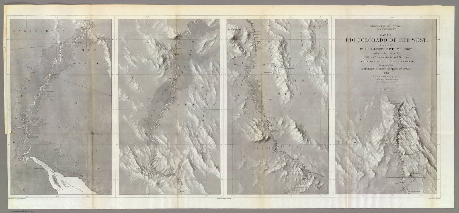
13. Explorations and Surveys. War Department. Map No. 2. Rio Colorado of the West, explored by 1st Lieut. Joseph C. Ives, Topl. Engrs. under the direction of the Office of Explorations and Surveys. A.A. Humphreys, Capt. Topl. Engrs. in Charge, by order of the Hon. John B. Floyd, Secretary of War. 1858. Drawn by Frhr. F.W.v. Egloffstein. Topographer to the Expedition. Topography by Frhr. F.W.v. Egloffstein. Ruling by Samuel Sartain. Lettering by F. Courtenay.

14. Explorations and Surveys. War Department. Map No. 1. Rio Colorado of the West, explored by 1st Lieut. Joseph C. Ives, Topl. Engrs. under the direction of the Office of Explorations and Surveys. A.A. Humphreys, Capt. Topl. Engrs. in Charge, by order of the Hon. John B. Floyd, Secretary of War. 1858. Drawn by Frhr. F.W.v. Egloffstein. Topographer to the Expedition. Topography by Frhr. F.W.v. Egloffstein. Ruling by Samuel Sartain. Lettering by F. Courtenay.
15. Sketch Of Country Between Haxall's Landing And Charles City Court House. Reconnoissances under the direction of Brig. Gen A.A. Humphreys, Comdg. Topl Engr's, by 1st Lieut. N. Bowen, Topl. Engrs., 2d Lieut. C. McClellan, 32d N.Y.. Vols., Mr. F.W. Dorr, Assist. U.S.C.S., Mr. Joseph McMakin, Drftsmn., Mr. H.H. Humpheys, Mr. Walter Taylor.

16. Map Of The Country Tributary To The Northern Pacific Railroad. Compiled from English, Canadian, and American official sources and original Surveys by Edward H. Knight. Jan. 1st. 1871. The compilation of English and Canadian charts and Surveys embracing the Northerly region of this Map, was platted in connection with the official U.S. War Department Map (the lower portion) at the Bureau of U.S. Topographical Engineers by the kind permission of Maj. Gen. A.A. Humphreys. (with profile).

17. Territory Of The United States From The Mississippi River To The Pacific Ocean; Originally prepared to accompany the Reports of the Explorations For A Pacific Railroad Route ... Compiled from authorized explorations and other reliable data by Lieut. G.K. Warren, Top'l. Eng'rs. In the Office of Pacific R.R. Surveys, War Dept. under the direction of Bvt. Maj. W.H. Emory, Top'l. Eng'rs. in 1854. Capt. A.A. Humphreys, Top'l. Eng'rs. in 1854-58. Recompiled and redrawn under the direction of the Chief of Corps of Engineers By Edward Freyhold 1865-66-67-68. Head Quarters Corp Of Engineers, War Department. Engraved & printed by Julius Bien, N.Y. (inset) Territory Of Alaska Ceded By Russia To The United States 1868.

18. Map Of The Territory Of The United States From The Mississippi To The Pacific Ocean; Ordered by the Hon. Jeff'n Davis, Secretary Of War To accompany the Reports of the Explorations For A Railroad Route ... Compiled from authorized explorations and other reliable data by Lieut. G.K. Warren, Topl. Engrs. In the Office of Pacific R.R. Surveys, War Dep. under the direction of Bvt. Maj. W.H. Emory, Topl. Engrs. in 1854 and of Capt. A.A. Humphreys, Topl. Engrs. 1854-5-6-7-8. Drawn by E. Freyhold. Engr. on Stone by J. Bien, 60 Fulton St. N.Y.

19. Map Of The Territory Of The United States From The Mississippi River To The Pacific Ocean; Originally prepared to accompany the Reports of the Explorations For A Pacific Railroad Route ... Compiled from authorized explorations and other reliable data by Lieut. G.K. Warren, Top'l. Eng'rs. In the Office of Pacific R.R. Surveys, War Dept. under the direction of Bvt. Maj. W.H. Emory, Top'l. Eng'rs. in 1854. Capt. A.A. Humphreys, Top'l. Eng'rs. in 1854-58. And partly recompiled and redrawn under the direction of the Engineer Bureau in 1865-66-67. Engineer Bureau, War Department. Engraved on stone by Julius Bien, New York.

20. (Composite of) A Map Of The Extremity Of Cape Cod Including the Townships of Provincetown & Truro: A Chart Of Their Sea Coast And Of Cape Cod Harbour, State of Massachusetts. Executed under the direction of Major J.D. Graham U.S. Top. Engs. During portions of the years 1833,'34, &'35 ... W.J. Stone Sc. Wash. Surveyed And Projected By J.D. Graham ... Drawn From The Original Projects And Notes, By J.E. Johnston ... A.A. Humphreys .... J.. Macomb ... W.R. Palmer ... Reduced from the original in the Bureau of U.S. Topographical Engineers, Washington, by Wash: Hood 1836.

21. A Map Of The Extremity Of Cape Cod Including the Townships of Provincetown & Truro: A Chart Of Their Sea Coast And Of Cape Cod Harbour, State of Massachusetts. Executed under the direction of Major J.D. Graham U.S. Top. Engs. During portions of the years 1833,'34, &'35 ... W.J. Stone Sc. Wash. Surveyed And Projected By J.D. Graham ... Drawn From The Original Projects And Notes, By J.E. Johnston ... A.A. Humphreys .... J.. Macomb ... W.R. Palmer ... Reduced from the original in the Bureau of U.S. Topographical Engineers, Washington, by Wash: Hood 1836.

22. Memoir to accompany a military map of the peninsula of Florida : south of Tampa Bay
Catalog
Books, media, physical & digital resources
Discovery Service for Jio Institute Digital Library
For full access to our library's resources, please sign in.