31 results on '"Warren, Gouverneur Kemble, 1830-1882"'
Search Results

2. (SE Sheet to) Territory Of The United States From The Mississippi River To The Pacific Ocean; Originally prepared to accompany the Reports of the Explorations For A Pacific Railroad Route ... Compiled from authorized explorations and other reliable data by Lieut. G.K. Warren, Top'l. Eng'rs. In the Office of Pacific R.R. Surveys, War Dept. under the direction of Bvt. Maj. W.H. Emory, Top'l. Eng'rs. in 1854. Capt. A.A. Humphreys, Top'l. Eng'rs. in 1854-58. Recompiled and redrawn under the direction of the Chief of Corps of Engineers By Edward Freyhold 1865-66-67-68. Head Quarters Corp Of Engineers, War Department. Engraved & printed by Julius Bien, N.Y. (inset) Territory Of Alaska Ceded By Russia To The United States 1868.

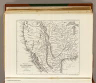
3. (SW Sheet to) Territory Of The United States From The Mississippi River To The Pacific Ocean; Originally prepared to accompany the Reports of the Explorations For A Pacific Railroad Route ... Compiled from authorized explorations and other reliable data by Lieut. G.K. Warren, Top'l. Eng'rs. In the Office of Pacific R.R. Surveys, War Dept. under the direction of Bvt. Maj. W.H. Emory, Top'l. Eng'rs. in 1854. Capt. A.A. Humphreys, Top'l. Eng'rs. in 1854-58. Recompiled and redrawn under the direction of the Chief of Corps of Engineers By Edward Freyhold 1865-66-67-68. Head Quarters Corp Of Engineers, War Department. Engraved & printed by Julius Bien, N.Y. (inset) Territory Of Alaska Ceded By Russia To The United States 1868.

4. (NE Sheet to) Territory Of The United States From The Mississippi River To The Pacific Ocean; Originally prepared to accompany the Reports of the Explorations For A Pacific Railroad Route ... Compiled from authorized explorations and other reliable data by Lieut. G.K. Warren, Top'l. Eng'rs. In the Office of Pacific R.R. Surveys, War Dept. under the direction of Bvt. Maj. W.H. Emory, Top'l. Eng'rs. in 1854. Capt. A.A. Humphreys, Top'l. Eng'rs. in 1854-58. Recompiled and redrawn under the direction of the Chief of Corps of Engineers By Edward Freyhold 1865-66-67-68. Head Quarters Corp Of Engineers, War Department. Engraved & printed by Julius Bien, N.Y. (inset) Territory Of Alaska Ceded By Russia To The United States 1868.

5. (NW Sheet to) Territory Of The United States From The Mississippi River To The Pacific Ocean; Originally prepared to accompany the Reports of the Explorations For A Pacific Railroad Route ... Compiled from authorized explorations and other reliable data by Lieut. G.K. Warren, Top'l. Eng'rs. In the Office of Pacific R.R. Surveys, War Dept. under the direction of Bvt. Maj. W.H. Emory, Top'l. Eng'rs. in 1854. Capt. A.A. Humphreys, Top'l. Eng'rs. in 1854-58. Recompiled and redrawn under the direction of the Chief of Corps of Engineers By Edward Freyhold 1865-66-67-68. Head Quarters Corp Of Engineers, War Department. Engraved & printed by Julius Bien, N.Y. (inset) Territory Of Alaska Ceded By Russia To The United States 1868.

6. Profiles from San Francisco Bay to Los Angeles, Cala. and from the Pimas Villages to Fort Fillmore from Explorations and Surveys made under the direction of The Hon. Jefferson Davis, Secretary of War by Lieut. John G. Parke, Topl. Engrs., assisted by Albert H. Campbell, Civil Engineer and N.H. Hutton, H. Custer and G.G. Garner, assts. 1854 & 55. Explorations and Surveys for a Rail Road Route from the Mississippi River to the Pacific Ocean. War Department. Route near the 32d parallel & coast route, Cala.

7. General profile from Fort Smith, Arkansas, to Martinez, near San Francisco, California, to accompany the maps of Explorations and Surveys made under the direction of Hon. Jefferson Davis, Secretary of War by Lieut. A.W. Whipple, Topl. engrs., assisted by Lieut. J.C. Ives, Topl. Engr., A.H. Campbell, civil engr. & surveyor, Wm. White, Jr., N.H. Hilton, J.P. Sherburne, asst. surveyors. 1853-4. Route near the 35th Parallel. (1861)

8. Profiles from Explorations and Surveys made under the direction of the Hon. Jefferson Davis Secretary of War. No. 1 Route near the 41st parallel; from Ft. Bridger to Ft. Reading by Capt. E.G. Beckwith, 3d. Artillery. No. 2 Route near the 38th & 39th parallel; from Westport to Sevier River by Capt. G.W. (i.e. J.W.) Gunnison, Topl. Engrs., assisted by Capt. E.G. Beckwith, 3d. Artillery. Profile made under the supervision of E.G. Beckwith, 3d. Art. 1855. (1861)

9. Profiles of the main routes surveyed, compiled in 1855, by Lieutenants G.K. Warren & H.L. Abbot, Corps Topl. Engineers; with revisions and additional compilations from the results of subsequent examinations and surveys. Prepared in the Office of Pacific Rail Road Explorations and Surveys. Captain A.A. Humphreys, Corps Topl. Engineers, in charge, by direction of Hon. Jefferson Davis, Secretary of War. 1856. Explorations and Surveys for the Rail Road Routes from the Mississippi River to the Pacific Ocean, War Department. (with) Profiles of rail roads constructed across the Alleghany mountains.

10. (Contents Page to) Topographical maps, profiles, and sketches to illustrate the various Reports of Surveys for railroad routes from the Mississippi River to the Pacific Ocean. Washington, D.C., 1861.

11. (Title Page to) Memoir to accompany the Map of the territory of the United States from the Mississippi River to the Pacific Ocean, giving a brief account of each of the exploring expeditions since A.D. 1800, with a detailed description of the method adopted in compiling the general map. By Lieut. Gouverneur K. Warren, Corps of Topographical Engineers, U.S.A. 1859.

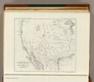
12. Reduced map of the territory west of the Rocky Mountains. By Capt. B.L.E. Bonneville, U.S.A. 1837. Lith of J. Bien, 60 Fulton St., N.Y. U.S. Pacific R.R. Exp. & Surveys. Lt. Warren's Memoir Plate IV. (1861)

13. (Contents Page to) Topographical maps, profiles, and sketches to illustrate the various Reports of Surveys for railroad routes from the Mississippi River to the Pacific Ocean. Washington, D.C., 1861.
14. Reduced section of a general map of North America. Drawn from the best surveys. 1795. To accompany Winterbotham's History. Published by John Reid, New York. Lith of J. Bien, 60 Fulton St., N.Y. U.S. Pacific R.R. Exp. & Surveys. Lt. Warren's Memoir Plate I. (1861)
15. (Contents Page to) Memoir to accompany the Map of the territory of the United States from the Mississippi River to the Pacific Ocean, giving a brief account of each of the exploring expeditions since A.D. 1800, with a detailed description of the method adopted in compiling the general map. By Lieut. Gouverneur K. Warren, Corps of Topographical Engineers, U.S.A. 1859.

16. (Title Page to) Topographical maps, profiles, and sketches to illustrate the various Reports of Surveys for railroad routes from the Mississippi River to the Pacific Ocean. Washington, D.C., 1861.
17. (Title Page to) Reports of Explorations and Surveys, to Ascertain the Most Practicable and Economical Route for a Railroad From the Mississippi River to the Pacific Ocean. Made Under the Direction of the Secretary of War, In 1853-56, According to Acts of Congress of March 3, 1853, May 31, 1854, and August 5, 1854. Volume XI. Washington: George W. Bowman, Printer. 1861. 36th Congress, 2d Session, Senate, Ex. Doc.
18. Reduced section of a sketch of the western part of the continent of North America between latitudes 35 (degrees) and 52 (degrees) Nth. 1818. Lith of J. Bien, 60 Fulton St., N.Y. U.S. Pacific R.R. Exp. & Surveys. Lt. Warren's Memoir Plate II. (1861)

19. Reduced section of map of North America including all the recent geographical discoveries. 1826. Lith of J. Bien, 60 Fulton St., N.Y. U.S. Pacific R.R. Exp. & Surveys. Lt. Warren's Memoir Plate III. (1861)
20. (Contents Page to) Reports of Explorations and Surveys, to Ascertain the Most Practicable and Economical Route for a Railroad From the Mississippi River to the Pacific Ocean. Made Under the Direction of the Secretary of War, In 1853-56, According to Acts of Congress of March 3, 1853, May 31, 1854, and August 5, 1854. Volume XI. Washington: George W. Bowman, Printer. 1861. 36th Congress, 2d Session, Senate, Ex. Doc.

21. (Covers to) Reports of Explorations and Surveys, to Ascertain the Most Practicable and Economical Route for a Railroad From the Mississippi River to the Pacific Ocean. Made Under the Direction of the Secretary of War, In 1853-56, According to Acts of Congress of March 3, 1853, May 31, 1854, and August 5, 1854. Volume XI. Washington: George W. Bowman, Printer. 1861. 36th Congress, 2d Session, Senate, Ex. Doc.

22. Map of the Territory of the U.S. West of the Miss. Riv. Sheet no. 5. (Prepared by authority of the Hon. the Secretary of War in the Office of the Chief of Engineers under the direction of Brig. General A.A. Humphreys Chief of Engineers and Brevet Maj. Gen. U.S. Army. By Edward Freyhold 1879)

23. Map of the Territory of the U.S. West of the Miss. Riv. Sheet no. 6. Prepared by authority of the Hon. the Secretary of War in the Office of the Chief of Engineers under the direction of Brig. General A.A. Humphreys Chief of Engineers and Brevet Maj. Gen. U.S. Army. By Edward Freyhold 1879.

24. (Map of the Territory of the U.S. West of the Miss. Riv. Sheet no. 2. Prepared by authority of the Hon. the Secretary of War in the Office of the Chief of Engineers under the direction of Brig. General A.A. Humphreys Chief of Engineers and Brevet Maj. Gen. U.S. Army. By Edward Freyhold 1879)

25. (Composite of) Map of the Territory of the United States, west of the Mississippi River. (Prepared by authority of the Hon. the Secretary of War in the Office of the Chief of Engineers under the direction of Brig. General A.A. Humphreys Chief of Engineers and Brevet Maj. Gen. U.S. Army. By Edward Freyhold 1879. (inset) Territory of Alaska.

26. (Covers to) Map of the Territory of the United States, west of the Mississippi River. (Prepared by authority of the Hon. the Secretary of War in the Office of the Chief of Engineers under the direction of Brig. General A.A. Humphreys Chief of Engineers and Brevet Maj. Gen. U.S. Army. By Edward Freyhold 1879. (inset) Territory of Alaska.

27. Map of the Territory of the U.S. West of the Miss. Riv. Sheet no. 4. (Prepared by authority of the Hon. the Secretary of War in the Office of the Chief of Engineers under the direction of Brig. General A.A. Humphreys Chief of Engineers and Brevet Maj. Gen. U.S. Army. By Edward Freyhold 1879) (with) Territory of Alaska.

28. Map of the Territory of the U.S. West of the Miss. Riv. Sheet no. 1. (Prepared by authority of the Hon. the Secretary of War in the Office of the Chief of Engineers under the direction of Brig. General A.A. Humphreys Chief of Engineers and Brevet Maj. Gen. U.S. Army. By Edward Freyhold 1879)

29. (Map of the Territory of the U.S. West of the Miss. Riv. Sheet no. 3. Prepared by authority of the Hon. the Secretary of War in the Office of the Chief of Engineers under the direction of Brig. General A.A. Humphreys Chief of Engineers and Brevet Maj. Gen. U.S. Army. By Edward Freyhold 1879)

30. Territory Of The United States From The Mississippi River To The Pacific Ocean; Originally prepared to accompany the Reports of the Explorations For A Pacific Railroad Route ... Compiled from authorized explorations and other reliable data by Lieut. G.K. Warren, Top'l. Eng'rs. In the Office of Pacific R.R. Surveys, War Dept. under the direction of Bvt. Maj. W.H. Emory, Top'l. Eng'rs. in 1854. Capt. A.A. Humphreys, Top'l. Eng'rs. in 1854-58. Recompiled and redrawn under the direction of the Chief of Corps of Engineers By Edward Freyhold 1865-66-67-68. Head Quarters Corp Of Engineers, War Department. Engraved & printed by Julius Bien, N.Y. (inset) Territory Of Alaska Ceded By Russia To The United States 1868.

31. Map Of The Territory Of The United States From The Mississippi River To The Pacific Ocean; Originally prepared to accompany the Reports of the Explorations For A Pacific Railroad Route ... Compiled from authorized explorations and other reliable data by Lieut. G.K. Warren, Top'l. Eng'rs. In the Office of Pacific R.R. Surveys, War Dept. under the direction of Bvt. Maj. W.H. Emory, Top'l. Eng'rs. in 1854. Capt. A.A. Humphreys, Top'l. Eng'rs. in 1854-58. And partly recompiled and redrawn under the direction of the Engineer Bureau in 1865-66-67. Engineer Bureau, War Department. Engraved on stone by Julius Bien, New York.

Catalog
Books, media, physical & digital resources
Discovery Service for Jio Institute Digital Library
For full access to our library's resources, please sign in.