689 results
Number of results to display per page
Search Results
2. Crisis Paper No. 32. The Middle East and the Super Powers.
- Author
-
Atlantic Information Centre for Teachers, London (England). and Critchley, Julian
- Abstract
This "Crisis Paper" examines the events of October, 1973, relating to the Middle East war. A chronology of events during the month is established, followed by short editorial commentary. A multi-national view of the situation is developed, quoting newspapers and journals from France, West Germany, USSR, China, Switzerland, Austria, Egypt, Lebanon, Iraq, Israel, the United Kingdom, and the United States and making up the bulk of the paper. Comments on various points made by the press follow the excerpts. The paper concludes with four questions for students to consider in light of the material presented. ED 065 433 is a related document. (JH)
- Published
- 1973
3. AICE Survey of USSR Air Pollution Literature, Volume 13: Technical Papers from the Leningrad International Symposium on the Meteorological Aspects of Atmospheric Pollution, Part 2.
- Author
-
American Inst. of Crop Ecology, Silver Spring, MD. and Nuttonson, M. Y.
- Abstract
Twelve papers were translated from Russian: Automation of Information Processing Involved in Experimental Studies of Atmospheric Diffusion, Micrometeorological Characteristics of Atmospheric Pollution Conditions, Study of theInfluence of Irregularities of the Earth's Surface on the Air Flow Characteristics in a Wind Tunnel, Use of Parameters of Eulerian Turbulence for Estimates of Lagrangian Characteristics, Method of Evaluating Atmospheric Diffusion from Turbulent Characteristics, Scattering of Smoke From a High-Level Point Source, Diffusion From a Point Source of Finite Time of Action, Use of Surface Observations for Characterizing the State of the Surface Atmospheric Layer, Sulfur Dioxide and Dust Measurements in Measuring Networks of the Hydrometeorological Institute, Experimental Studies of Atmospheric Pollution in Industrial Areas, Field Studies of Air Pollution in the Area of the Skawina Electric Power Plant, and Effect of Meteorological Conditions on Air Pollution in Cities of the Soviet Union. (BT)
- Published
- 1972
4. Robert P. Higgins Papers : field data, Tobago, USSR, South Pacific Ocean, 1965, 1968, 1986, 1989, 1991
- Author
-
Higgins, Robert P., Smithsonian Institution Archives, and Higgins, Robert P.
- Subjects
Field notes ,Higgins, Robert P ,Marine invertebrates ,National Museum of Natural History (U.S.) ,Russia ,Smithsonian Institution ,South Pacific Ocean ,Soviet Union ,Tobago ,Zoology - Published
- 1965
5. Robert P. Higgins Papers : field data, USSR, Antarctic, 1957, 1963-1964, 1972, 1986
- Author
-
Higgins, Robert P., National Museum of Natural History (U.S.) Dept. of Invertebrate Zoology, Smithsonian Institution Archives, Higgins, Robert P., and National Museum of Natural History (U.S.) Dept. of Invertebrate Zoology
- Subjects
Antarctica ,Arctic Ocean ,Black Sea ,Dept. of Invertebrate Zoology ,Field notes ,Higgins, Robert P ,Marine invertebrates ,National Museum of Natural History (U.S.) ,Russia ,Soviet Union ,Zoology - Published
- 1957
6. [Industrial microclimate and its effect on the physiological functions and morbidity of workers in paper mills]
- Author
-
N N, Krasnoshchekov and G M, Cherviakov
- Subjects
Occupational Diseases ,Paper ,Climate ,Humans ,Sweating ,Skin Temperature ,Body Temperature ,Russia - Published
- 1973
7. Twelfth Annual Report on Introduction of Domestic Reindeer into Alaska, with Map and Illustrations, 1902
- Author
-
Bureau of Education (DOI), Alaska Division, US Senate, and Jackson, Sheldon
- Abstract
Following a letter of transmittal, this document presents the 12th annual report on the introduction of reindeer into Alaska. The document includes commendations for several Lapp and native herders in Education Commissioner W.T. Harris's report-transmittal letter to the Senate. The report by General Agent for Education in Alaska, Sheldon Jackson, notes that a prosperous year has passed. With the spring birth of 1,651 fawns and purchase of 30 deer, the herds total 5,148 head. There are 27 Eskimo apprentices learning herd management and care. Although the winter of 1901-02 was the coldest since 1894, the light snowfall meant there was no fall thaw covering the moss that would inhibit feeding. Jackson reports on the Teller Reindeer Station and the Point Barrow, Kotzebue, Cape Prince of Wales, Gambell, Golofnin, Eaton, Nulato, and Kuskokwim herds. Following news that the Russian government prohibited reindeer exportation to Alaska, a U.S. request was made to allow 300 head to be bought in summer 1902. The Russians consented as long as coin rather than barter was used. Jackson recommends that the U.S. government seek an agreement with the Russians for using barter when trying to purchase from Siberian natives who have never used circulating money and are completely unfamiliar with it. Jackson noted that customs law on animals purchased from Asia came to his attention, and thus he also advised that a customs inspector accompany the reindeer purchasing party and inspect the reindeer before leaving Siberia, given the difficulty in bringing the animals from Siberia to San Diego for customs inspection and then taking them to Alaska. Data breaks out reindeer ownership in the region, five-year increase, congressional appropriations, and reindeer-fund expenditures. Jackson also details the school and reindeer-station inspection itinerary of Assistant Agent William Hamilton, and covers reindeer transportation, the 260-mile reindeer mail route in which one experienced carrier froze to death with no loss of his herd, herd transfers, and the value of reindeer for missions. Jackson details his school- and herd-inspection itinerary from Washington on June 27, 1902. He returned to Washington on September 10, 1902, after journeying 15,108 miles. Appendices include letters of instruction; correspondence on Bureau of Education agents' transportation; official papers on reindeer inspection; annual reports from the Point Barrow, Kotzebue, Cape Prince of Wales, Gambell, Teller, Golofnin, Eaton, Nulato, and Bethel Reindeer Stations; the Teller Reindeer Station daily log book and meteorological record; extracts from Eskimo apprentice Sepilla's daily journal; and papers concerning herd transfer, purchasing, loan, and mail usage; as well as a memorandum on the potential economic value of cod-liver oil if fish are caught from August to March around the Kodiak, Shumagin, and Sunnak Banks.
- Published
- 1903
8. Eleventh Annual Report on Introduction of Domestic Reindeer into Alaska, with Map and Illustrations, 1901. Senate of the United States, 54th Congress, 1st Session. Document No. 98
- Author
-
Bureau of Education (DOI), Alaska Division, US Senate, and Jackson, Sheldon
- Abstract
General Agent for Alaskan Education Sheldon Jackson's 11th annual report to the Interior secretary on the introduction of reindeer into Alaska from Siberia notes that a number of reindeer were secured from the Ola, Siberia, region for crossing with existent herds. Jackson reports on the herds at Eaton Reindeer Station, at mission stations, and Point Hope. He observes that the annual inspection is a learning opportunity for both superintendents and herders. Data is broken out on herd distribution, five-year increase, congressional appropriations, and expenditures. During the reindeer project's 10 years, 30 to 35 herders have served an apprenticeship of two to five years. Among them, 20 now have their own reindeer. The enterprise's growth has become profitable. Reindeer have transported goods for relief of snowbound troops building telegraph lines, telegraph poles, and telegraph supplies. They have also taken men and supplies to mining camps. Reindeer are the only draft animal in Alaska that can secure its own food when traveling. Although some in the U.S. consider the congressional reindeer appropriation uselessly expended, Jackson observes that the appropriation provides for emergencies that may happen at any time, especially with the great influx of gold miners. A branding system has been developed to distinguish 19 ownerships. On March 30, 1901, President William McKinley issued an executive order establishing lands to be set aside for reindeer stations. Jackson details his itinerary, leaving Washington, D.C., for Alaska on May 4, 1901, and returning on November 5, 1901, a trip of 15,400 miles. On the trip, Jackson inspected schools and reindeer stations and procured reindeer. Appendices include a report on missions' education work, the Eaton Reindeer Station annual report and daily journal, other reindeer station reports, papers on U.S. soldiers' relief, discussion of reindeer brands, and papers related to Jackson's trip and his transportation, among others.
- Published
- 1902
9. [Planning of large city hospitals (apropos of the paper by V.A. Miniaev)]
- Author
-
M E, Petrov
- Subjects
Hospital Planning ,Humans ,Russia - Published
- 1968
10. Production of the chironomids of the Uchinsk Reservoir. [Translation of: Methods for the estimation of production of aquatic animals. (Handbook and papers) (ed. G. G. Vinberg) p226-239. Minsk, Vysheishaya Shkola, 1968]
- Author
-
Sokolova, N. Y.
- Subjects
Ecology ,Population dynamics ,Freshwater lakes ,fungi ,Limnology ,Freshwater ecology ,Invertebrate larvae ,Biomass ,Biology ,Chironomidae ,Russia - Abstract
The method of E.V. Borutski was used for determining the production of chironomids, that is, the dynamics of the number and biomass of the larvae were analysed, their death, a calculation of emergence and the number of deposited egg layings was carried out. In addition to the method of Borutski, the authors also calculated the seasonal dynamics of the number of larvae of the younger age stages in the microbenthos. Translated from Russian into English
- Published
- 1968
11. [The weekly paper 'Medical News'. A sketch on the history of Russian medical journalism]
- Author
-
G L, MAGAZANIK
- Subjects
Ethnicity ,Humans ,History of Medicine ,Periodicals as Topic ,Russia - Published
- 1959
12. Russian papers on leprosy
- Author
-
J. R. Innes
- Subjects
medicine.medical_specialty ,business.industry ,Family medicine ,Leprosy ,Medicine ,Humans ,General Medicine ,business ,medicine.disease ,Russia - Published
- 1960
13. [Experimental study of the sterilization of prescriptions and paper by ultraviolet radiation]
- Author
-
P V, Lopatin, A M, Kats, E P, Iarantseva, T M, Fedorova, and L V, Gorskaia
- Subjects
Radiation Effects ,Ultraviolet Rays ,Sterilization ,Pharmacy ,Russia - Published
- 1965
14. [Organization of antituberculosis work at the plants of the timber, paper and woodwork industries]
- Author
-
S G, Sherman and Iu V, Leshukovich
- Subjects
Occupational Diseases ,Disability Evaluation ,Occupational Medicine ,Organization and Administration ,Humans ,Tuberculosis, Pulmonary ,Wood ,Russia - Published
- 1973
15. Soviet Studies in the Psychology of Learning and Teaching Mathematics, Volume 3, Problem Solving in Arithmetic and Algebra.
- Author
-
Stanford Univ., CA. School Mathematics Study Group., Chicago Univ., IL., Kilpatrick, Jeremy, and Wirszup, Izaak
- Abstract
The series "Soviet Studies in the Psychology of Learning and Teaching Mathematics" is a collection of translations from the Soviet Literature of the past twenty-five years on research in the psychology of mathematical instruction. Also included are works on methods of teaching mathematics directly influenced by this research. The aim of this series is to acquaint mathematics educators and teachers with directions, ideas, and accomplishments in the psychology of mathematical instruction in Russia. Volume III of the series contains four papers: three on arithmetic and one on algebra. These papers are directed at the theoretical analysis of thinking processes. Each paper discusses investigations related to processes students use in solving word problems in mathematics. Some of the findings reported in this volume are unique to the Soviet educational system, but the value of using problem material from the school curriculum in studying problem-solving processes is demonstrated in each of the papers. (Author/FL)
- Published
- 1969
16. English-Language Sources for Reference Questions Related to Soviet Science (With an Emphasis on Chemistry).
- Author
-
Illinois Univ., Urbana. Graduate School of Library Science. and Wiggins, Gary
- Abstract
The vast majority of science librarians and chemists in the United States do not have a sufficient command of the Russian language to effectively utilize Russian scientific literature in the original. Nevertheless, it is both desirable and necessary that the scientific community keep aware of developments in the Soviet Union. To meet this need, a considerable amount of material which deals with Soviet science has been made available in English. Not only is a large portion of the Russian scientific literature translated into English, but researchers may also consult many English-language articles, monographs, and reference works which treat Soviet science. The first part of this paper is a bibliographic essay on the more significant sources of English-language information which either provide answers to many reference questions concerning Soviet science or outline procedures for keeping aware of and obtaining Soviet scientific literature in English. This is a reference guide to materials which will allow the librarian or scientist with no knowledge of the Russian language to maintain a fair degree of awareness of Soviet science without consulting material in Russian. (Author/NH)
- Published
- 1972
17. SURVEY OF BIBLIOGRAPHIES AND REFERENCE WORKS ON ASIA, AFRICA, LATIN AMERICA, RUSSIA, AND EAST EUROPE--AND COMPILATION OF BIBLIOGRAPHIES ON EAST ASIA, SOUTH ASIA AND AFRICA SOUTH OF THE SAHARA FOR UNDERGRADUATE LIBRARIES. INTERIM REPORT, PHASE ONE.
- Author
-
State Univ. of New York, New York. Foreign Area Materials Center. and MOREHOUSE, WARD
- Abstract
THE PURPOSE OF THE PROJECT IS TO ASSIST UNDERGRADUATE LIBRARIES IN STRENGTHENING THEIR RESOURCES ON AREAS OUTSIDE THE PERIMETER OF WESTERN CIVILIZATION USUALLY GIVEN LITTLE ATTENTION BY AMERICAN COLLEGES, WITH SPECIAL EMPHASIS ON EAST AND SOUTH ASIA AND AFRICA SOUTH OF THE SAHARA. UNDER THE PROJECT'S FIRST PHASE, A PANEL OF LIBRARY ADVISERS WAS ESTABLISHED, AND PRELIMINARY VERSIONS OF A GUIDE TO REFERENCE MATERIALS ON NON-WESTERN EUROPEAN AREAS AND BIBLIOGRAPHIES ON EAST ASIA, SOUTH ASIA, AND AFRICA SOUTH OF THE SAHARA HAVE BEEN COMPILED BY COLLATING EXISTING BIBLIOGRAPHIES AND ADDING RECENTLY PUBLISHED ITEMS. THE BIBLIOGRAPHIES WERE PREPARED BY COMPUTERS, USING WITH SUCCESS THE DATATEXT SYSTEM FOR SOURCE DATA ENTRY. THE FINAL VERSIONS WILL BE ISSUED AFTER REVISION AND GRADING BASED ON ADVICE FROM SCHOLARS AND LIBRARIANS. INCLUDED AS AN APPENDIX IS THE REPORT OF A CONFERENCE ON THE PLACE OF NON-EUROPEAN LANGUAGE MATERIALS IN UNDERGRADUATE LIBRARIES (CHICAGO, NOVEMBER 17, 1967). TOPICS DISCUSSED BY FACULTY AND LIBRARIAN PARTICIPANTS INCLUDE THE IMPACT ON UNDERGRADUATE LIBRARIES FROM IMPROVED LANGUAGE INSTRUCTION AND INCREASING FACULTY NEEDS FOR RESEARCH MATERIALS IN NON-ENGLISH LANGUAGES. CONFERENCE RECOMMENDATIONS ON APPROPRIATE ACQUISITIONS IN THESE AREAS CONCLUDE THE REPORT. ALSO APPENDED IS A PAPER READ AT THE CONFERENCE--"SOME REFLECTIONS ON THE USE OF RUSSIAN LANGUAGE MATERIALS ON THE COLLEGE LEVEL AND DESIRABLE FUTURE DIRECTIONS IN THIS AREA," BY DOUGLAS READING. (JB)
- Published
- 1967
18. Annual Report of the Secretary of the Interior for the Fiscal Year Ended June 30, 1895. In Five Volumes. Volume V -- In Two Parts. Part 1 [Report of the Commissioner of Education]
- Author
-
Department of the Interior, United States Bureau of Education (ED)
- Abstract
This is the Report of the Commissioner of Education, part of the Annual Report of the Secretary of the Interior for the Fiscal Year Ended June 30, 1895. The Bureau of Education report is contained within volume five, which is in two parts. Part one contains: (1) The Commissioner of Education's Introduction; (2) Statistics of State Common-School Systems; (3) City School Systems; (4) Statistical Review of Secondary Schools; (5) Statistical Review of Normal Schools; (6) Statistical Review of Higher Education; (7) Statistical Review of Professional Schools; (8) The Educational Systems of England and Scotland, with Statistics for 1893-94; (9) Manitoba School Case; (10) Education in France; (11) Public Education in Belgium; (12) Education in Central Europe; (13) Education in the Netherlands; (14) Education in Italy; (15) Report of the Loyal Commission on Secondary Education; (16) Papers Accompanying the Report of the Loyal Commission on Secondary Education; (17) Higher Education in Russian, Austrian, and Prussian Poland; (18) Art education in the public schools; (19) Facilities for the University Education of Women in England; (20) Educational Status of Women in Different Countries; (21) Chautauqua: A Social and Educational Study; (22) Pensions for Teachers; (23) Coeducation--Compulsory Attendance--American Students in Foreign Universities--Continuation and Industrial Schools; and (24) Educational Directory. [For the first part of the Commissioner of Education's 1894-95 report, see "Report of the Commissioner of Education for the Year 1894-95. Volume 2. Containing Parts II and III" (ED622083).]
- Published
- 1896
19. Report of the Commissioner of Education for the Year 1892-93. Volume 1. Containing Parts I and II
- Author
-
Department of the Interior, United States Bureau of Education (ED)
- Abstract
This is Volume 1 of the Report of the Commissioner of Education for the Year 1892-93, containing Parts I and II. This volume begins with the Commissioner of Education's Introduction. Part I covers the topics: (1) Statistical Summaries; (2) Illiteracy in the United States; (3) System of Public Education in Belgium; (4) Elementary Education in Great Britain; (5) Education in France; (6) Education in Ontario, New Zealand, and India; (7) Recent Developments in the Teaching of Geography in Central Europe; (8) The Common School System of Bavaria; (9) Education in Uruguay; (10) Child Study; (11) Bibliography of Herbartianism; and (12) Name Register. Part II, Education and the World's Columbian Exposition, covers the topics: (1) Programme of the International Congress of Education and Addresses of Welcome; (2) American Views and Comments on the Educational Exhibits; (3) German Criticism on American Education and the Educational Exhibits; (4) French Views upon American Education and the Educational Exhibits; (5) Medical Instruction in the United States as presented by French Specialists; (6) Notes and Observations on American Education and the Educational Exhibits, by Italian, Swedish, Danish, and Russian Delegates; (7) American Technological Schools; (8) Higher Education of Women in Russia; (9) Papers Prepared for the World's Library Congress; and (10) Notes on Education at the Columbian Exposition. [For "Report of the Commissioner of Education for the Year 1892-93. Volume 2. Containing Parts III and IV," see ED622070.]
- Published
- 1895
20. The Training of Teachers of Mathematics for the Secondary Schools of the Countries Represented in the International Commission on the Teaching of Mathematics. Bulletin, 1917, No. 27
- Author
-
Department of the Interior, Bureau of Education (ED) and Archibald, Raymond Clare
- Abstract
This bulletin is based upon reports to the International Commission on the Teaching of Mathematics concerning the development of the teacher of mathematics in the better secondary schools of different countries. For the most part, only those schools which are under the immediate direction of the Government have been considered. And even here discussion is limited to the best schools for boys and to the teachers in such schools. As a rule, the schools for girls are not as completely organized or of so high a standard. Included in this bulletin, when possible, are brief independent sketches of the educational conditions in the various countries, so that the readers may receive here in connected form condensed but definite accounts of the following phases of educational work in the country under discussion, in so far as they bear on the preparation of teachers of secondary mathematics: (1) the general educational scheme; (2) secondary schools and their relation to that scheme; (3) the mathematics taught in the secondary schools and the pupils to whom it is taught; (4) the inducements (such as salary, pensions; social position) to young men to take up secondary-school teaching as a profession; (5) the universities of the country, the courses of mathematics and allied subjects they offer, and the diplomas or certificates they confer. The countries profiled include Australia, Austria, Belgium, Denmark, England, Finland, France, Germany, Hungary, Italy, Japan, the Netherlands, Roumania, Russia, Spain, Sweden, Switzerland, and the United States. The following are appended: (A) England: Cambridge local examinations, senior students; Oxford and Cambridge schools, examination board; University of London, matriculation examinations; (B) England: Entrance scholarships examination papers, Cambridge University; (C) France: Concours for admission to the Ecole Normale Superieure and for the Courses de licenses in 1913; (D) Agregation des sciences mathematiques; (E) Germany: Reifeprufungen; Lehramtsprufungen; (F) Japan; Examination questions. This bulletin was produced with the editorial cooperation of Smith, D. E.; Osgood, W. F.; and Young, J. W. A. An index is provided. (Individual chapters contain footnotes and tables.) [Best copy available has been provided.]
- Published
- 1918
21. 25. Динамика численности жен- щин в бумажной и полигра- фической промышленности (1923-1932 rr.).(Dynamics of the number of women in paper and printing industry (1923-1932 rr.).)

- Author
-
Vlast’ Sovetov, Novikov, N., Zagumennykh, M., and Svirinovskaya, S.
- Subjects
Data Visualization - Abstract
"A rare masterpiece of Soviet book-making, comprised of 35 superb photomontage plates celebrating the emancipation of Soviet women and their involvement in the early development of the country between 1922 and 1933. Beginning with the broadening of women’s suffrage in the 1920s,the book also covers the dynamics of increasing female membership of both party and administrative organizations, the structure of factories, and the Komsomol organization; the extent of women’s udarniki (shock brigades) by the end of the first Five Year Plan; the increasing educational attainment of Soviet women. Some crucially significant diagrams were dedicated to the demonstration of how the socialist daily routine liberated women from household duties. Each chart is designed as a separate poster on a single topic which visualizes statistical data in striking geometric figures. The leaves were also decorated with photomontages, varying by topic. A poster about female udarniki features a full-body drawing of a woman placed next to a pyramid split into sections denoting different industries and indicating different levels of worker enthusiasm in percentage terms. In the background, photographs are montaged of various work processes and a newspaper, Izvestia, about udarniki. Under the pyramid, an average measure of worker enthusiasm in different Soviet industries is shown, along with data on railroad and communal housing construction." A fine copy with OCLC finding just one other at the Library Congress." (Adam Gorfin, 2023)
- Published
- 1933
22. Paper cover for the portfolio, L'Art décoratif théâtral moderne (Paris: La Cible, 1919)
- Author
-
Larionov, Ivan and Fine Arts Museums of San Francisco
- Subjects
- European, Eastern European, Russian, Russia
- Published
- 1881
23. La formation des professeurs de geographie en URSS (The Training of Geography Teachers in Russia)
- Author
-
Konstantinov, Oleg
- Abstract
Paper presented to the Commission on Geography in Education, Quebec, Canada, August 1972. (DS)
- Published
- 1972
24. METHODS OF TEACHING PHYSICS IN SOVIET SECONDARY SCHOOLS.
- Author
-
Israel Program for Scientific Translation, Jerusalem. and YUS'KOVICH, V.F
- Abstract
THIS VOLUME IS A COLLECTION OF EIGHT PAPERS DEALING WITH ASPECTS OF TEACHING PHYSICS TO RUSSIAN STUDENTS IN GRADES FIVE THROUGH ELEVEN. TOPICS OF PAPERS ARE (1) THE PRESENT SITUATION IN THE METHOD OF HIGH-SCHOOL PHYSICS AND ITS BEARING ON THE POLYTECHNICAL INSTRUCTION SYSTEM, (2) THE DEVELOPMENT OF RATIONAL THOUGHT IN STUDENTS DURING THE TEACHING OF PHYSICS IN THE SECONDARY SCHOOL, (3) THE ELECTRICAL PROPERTIES OF THE SOLID STATE TO BE TAUGHT IN PHYSICS, (4) EXPERIMENTAL FINDINGS CONCERNING THE TEACHING OF HEAT AND WORK IN THE NINTH GRADE AND DIRECT CURRENT IN THE TENTH GRADE, (5) SOME METHODOLOGICAL ASPECTS OF TEACHING ELECTROMAGNETIC FIELD PHENOMENA IN THE SECONDARY SCHOOL, (6) THE USE OF ANALOGY IN THE SECONDARY-SCHOOL PHYSICS COURSE, (7) THE TRAINING OF STUDENTS FOR PRACTICAL WORK IN PHYSICS, AND (8) TECHNICAL CREATIVITY OF STUDENTS IN PHYSICS HOBBY GROUPS. DISCUSSED ALSO ARE (1) HISTORICAL PHILOSOPHY OF THE DEVELOPMENT OF THE PHYSICS CURRICULUM FROM THE TIME OF THE OCTOBER REVOLUTION UNTIL 1959, (2) TECHNIQUES FOR THE DEVELOPMENT OF RATIONAL THOUGHT IN STUDENTS BY MEANS OF THE PHYSICS COURSE, (3) THE USES AND MISUSES OF ANALOGIES AS METHODOLOGICAL TOOLS FOR TEACHING PHYSICS, AND (4) THE SPECIAL TRAINING OF STUDENTS FOR PRACTICAL WORK. PUBLISHED IN MOSCOW IN 1959, THIS BOOK WAS TRANSLATED INTO ENGLISH BY THE ISRAEL PROGRAM FOR SCIENTIFIC TRANSLATIONS. THIS DOCUMENT IS AVAILABLE FOR $7.50 FROM DANIEL DAVEY AND COMPANY, 257 PARK AVENUE SOUTH, NEW YORK, NEW YORK 10010. (DG)
- Published
- 1966
25. [New species of brown Actinomycetes--Actinomyces luminobadius n. sp]
- Author
-
K A, Vinogradova, L I, Petrova, and V A, Poltorak
- Subjects
Chromatography, Paper ,Actinomycetales ,Luminescent Measurements ,Actinomyces ,Soil Microbiology ,Culture Media ,Russia - Published
- 1973
26. [Black-brown intracellular pigment in Actinomyces brunneorectus]
- Author
-
N A, Krasil'nikov, G M, Zenova, and O A, Bushueva
- Subjects
Chromatography, Paper ,Spectrophotometry ,Actinomyces ,Pigments, Biological ,Soil Microbiology ,Culture Media ,Russia - Published
- 1974
27. Presse und öffentliche Meinung
- Author
-
Eckardt, Hans von and Deutsche Gesellschaft für Soziologie (DGS)
- Subjects
Deutsches Reich ,Faschismus ,Öffentlichkeit ,Journalist ,documentation ,ddc:070 ,Wirkung ,Russia ,Dokumentation ,news ,German Reich ,Weimarer Republik ,Berichterstattung ,reporting ,effect ,the public ,Massenmedien ,historical ,Masse ,Meinungsforschung ,Italy ,Russland ,Presse ,politics ,Public Opinion Research ,Politik ,political influence ,Print Media ,Italien ,freedom of the press ,reader (person) ,mass media ,Zeitung ,press ,Pressefreiheit ,Massengesellschaft ,News media, journalism, publishing ,Nachrichten ,historisch ,politischer Einfluss ,daily paper ,Weimar Republic (Germany, 1918-33) ,Druckmedien ,Leser ,öffentliche Meinung ,public opinion ,mass ,fascism ,Publizistische Medien, Journalismus,Verlagswesen ,newspaper ,mass society ,Tageszeitung - Published
- 1930
28. [Comparative characteristic of the flavonoid composition of Sideritis taurica, Maschalliana and ajpetriana]
- Author
-
I M, Fefer
- Subjects
Flavonoids ,Plants, Medicinal ,Chromatography, Paper ,Glycosides ,Russia - Published
- 1971
29. [Morbidity with temporary loss of working capacity among 'year-round' and skilled worker contingents]
- Author
-
F L, Laĭko
- Subjects
Male ,Occupational Diseases ,Paper ,Disability Evaluation ,Humans ,Female ,Morbidity ,Cellulose ,Russia - Published
- 1973
30. Second Thought.
- Subjects
EPISCOPALIANS - Published
- 1948
31. America, Russia, hemp, and Napoleon: a study of trade between the United States and Russia, 1783-1814
- Author
-
Crosby, Alfred Worcester
- Subjects
- Hemp, United States, Russia, International trade, Agriculture
- Abstract
Trade between the United States and Russia has never been given much attention by American historians, particularly by those American historians specializing in studies of our early national period. Therefore, he who would do research on early Russo-American commerce must pore over the manuscript consular and ministerial reports of the American State Department archives, the Massachusetts Historical Society microfilms of the diary and letters of John Quincy Adams, and the manuscript log, letter and account books of the Peabody Museum and Essex Institute of Salem, Massachusetts. In the early national period of the United States no field of economic endeavor except agriculture was of greater importance to our young republic than our overseas trade. The merchant marine was one of the most important tools in the creation of American economic viability and in the reinforcement of the political independence so recently won. Our merchant marine a.n:i our navy could not have operated without Russian imports: iron, sailcloth and -most important of all - hemp and hemp cordage. In the age of sail, hemp was as critically important as is oil today, for hemp cordage was the ligaments and nerves of the sailing ship. Some hemp was raised in the United States, but of such poor quality that when exposed to brine or to salt spray it quickly deteriorated. Most hemp used on American ships was grown in Russia. Russo-American trade was also important in the history of Russia and Europe as a whole. Russia was an ally of Napoleon when he created his Continental System by forbidding his empire and allies to trade with the British. However, Russia's best market was Britain and Britain's best source of essential naval stores was Russia. At the same time, Americans were discovering that the economic warfare between France and Britain was making the ports of all of Europe directly or nearly directly under Napoleon's control very dangerous for American shipping. Even the usually peaceful Danes, for instance, seized several hundred American merchantmen between 1807 and the outbreak of the War of 1812. It was inevitable that Russia, the continental European nation farthest from Napoleon's center of power, would become one of our most important trading partners. In 1811, for example, one tenth of all America's exports went to Russia. It was also inevitable that many Americans would engage in smuggling goods to and from Russia fer the British. And it was inevitable that Britons would disguise their own merchantmen with American flags and papers, and continue direct trade with Russia under false colors. Thus it was that from 1808 through 1812 the foreign flag most commonly seen in Russia's Baltic and White Sea ports was the Stars and Stripes. In the summer of 1811, for instance, a hundred vessels flying the American nag lay in Kronstadt harbor at one time. Napoleon sent demand after demand to Tsar Alexander I to halt all trade with American vessels. All Americans, the Corsican claimed, were either British or sailing on British account. From 1809 through the winter of 1812 Napoleon's ambassadors to Russia, Caulaincourt and Lauriston, fought America's minister to Russia, John Quincy Adams, for Alexander's favor. Adams won, because Alexander knew that the bulk of Russia's foreign trade was now being carried in American bottoms. To sever trade relations with the United States would have had a disastrous effect on Russia's already staggering economy. Probably Russia's lax enforcement of the Continental System against shipping flying the American colors was as important as any other single factor in convincing Napoleon that he must invade Russia, and therefore in bringing the French Einpire to wreck upon the white reefs of the Russian winter of 1812.
- Published
- 1961
32. The Chinese Communist Problem
- Author
-
Pearson, Jim Berry
- Subjects
- Chinese Communists, history, Russia, power, Communism -- China.
- Abstract
This paper is a study of the history of the Chinese Communists, what they stand for, how they attained power in China, their connection to Russia, and the dangers of their success.
- Published
- 1949
33. THE MEDIEVAL EMERGENCE OF THE VOLG-OKA REGION.
- Author
-
Morris, A. S.
- Subjects
PHYSICAL geography ,GEOGRAPHY ,POWER (Social sciences) ,AGRICULTURE - Abstract
The relocation of the medieval East Slav state center from the middle Dnieper to the Volga-Oka region was a lateral shift within the potentially most useful agricultural land, rather than a retreat from fertile steppes into the forest. The physical geography of the Volga-Oka interfluve region around Moscow is less inviting, but similar in many respects to the middle Dnieper region around Kiev, and medieval agriculture was highly developed in both regions. The Volga-Don region developed later, but was not merely a land of hunters and herders when political power was transferred. The early Slavic settlers probably had learned about the environment from their Finnic neighbors, and a solid agricultural economy was based upon the use of light plows, for which the light soils were no great disadvantage. The economic strength of the Volga-Oka region was second only to that of Kiev, and it immediately assumed power when the latter fell. The various reasons for the particular success of the little Moscow principality within the region are reinforced by a better understanding of regional trends. [ABSTRACT FROM AUTHOR]
- Published
- 1971
- Full Text
- View/download PDF
34. Russian Empire. Warnicke Sculp.

- Author
-
Carey, Mathew and Warnicke, John G.
- Subjects
- Japan, Russia
- Abstract
In full color by province. This map is changed from the 1814 edition., Full color copy of the first atlas made in the United States to employ standard color on the maps; while the Carey 1795 American Atlas and the Carey 1811 General Atlas list color as an option on the title page, we have never seen any copies of a pre 1814 Carey atlas with original color - they may exist, but would be rare - color was first employed as standard in this 1814 edition - all copies that we have seen have been colored. The 1814 edition is almost entirely new, with most of the maps reengraved. The 1804 edition before this was essentially the same as the 1795 first edition. This 1815 edition changes two maps from the 1814 edition: North Carolina and the Russian Empire. The preface remains dated March 17th, 1814, the same as the 1814 edition preface. This 1815 edition should probably be called the 2.5 edition even though Carey does not label it as such, because Carey calls the 1818 edition the third edition and we call the 1814 edition the 2.0 edition. The Map of the United States is an updated copy of the U.S. map engraved by Henry Tanner that appeared in the first edition of Melish's Travels In the United States, published in 1812. A second Map of the United States of America by H.S. Tanner is tipped in after the standard U.S. map. It is from Tanner's 1812 College Atlas (see our 12139.009). Bound in quarter leather, brown paper covered boards. From Ruderman description: "An Extraordinary Full Original Color / Extra-Illustrated Example With An Important American Provenance The First Atlas in the United States With Standard Color on the Maps With Important Maps of the West (Including Texas) Beginning in 1814, Mathew Carey introduced several significant innovations to Carey's General Atlas. These included a new set of plates, replacing those in use since 1794-'96 in his American Atlas, General Atlas for Gutherie's Geography, and General Atlas. In addition, for the first time in America, Carey offered the atlas in original outline color, making it one of the earliest American color plate books and the first American Atlas to employ hand coloring. The present example, unlike the standard outline color, is offered here in full original wash color. This is only the second complete example of the atlas we have seen in full original color. In addition, the present example includes an extra map, A Map of the United States by H.S. Tanner, which was likely first issued in about 1822 or 1823 and intended to be folded into William Darby’s Universal Gazetteer, although the present example shows no signs of having been folded into another book. The present example bears an imprint date of 1815, which is also extremely rare. The maps in Carey's General Atlas represented a significant step forward in American cartographic content. Of particular note here is the map of the Missouri Territory, which incorporates recent information from Lewis & Clark (see below). Interestingly, this atlas was published 1814, the same year as the first edition of the official History of the Expedition under the Command of Captains Lewis and Clark (Philadelphia, 1814), with its famous and influential map of Western America. In fact, Matthew Carey had published Patrick Gass's journal, the first book length work stemming from the Lewis & Clark expedition, in 1810: Carey's interest in geography and exploration ran deep and helped shape both his own writing as well as the titles he published. Significant in Carey's connection to the Lewis and Clark Expedition was his publication of Thomas Jefferson's Notes on the State of Virginia (1794)... containing a "Map of Virginia" by Samuel Lewis...Carey also hired Samuel Lewis, a skilled cartographer who later redrew William Clark's map of the American West... - The Literature of the Lewis and Clark Expedition, page 98. Carey is also considered America's first commercial publisher. In the lower margin of the first page of Carey's Prefatory Remarks is printed: (Price Fifteen Dollars), a princely sum in 1814 for an atlas or any book! Rumsey (4577) says of the 1814 edition of Carey's General Atlas: The first atlas made in the United States to employ standard color on the maps; while the Carey 1795 American Atlas and the Carey 1811 General Atlas list color as an option on the title page, we have never seen any copies of a pre 1814 Carey atlas with original color - they may exist, but would be rare - color was first employed as standard in this 1814 edition - all copies that we have seen have been colored. This edition is almost entirely new, with most of the maps reengraved. The 1804 edition before this was essentially the same as the 1795 first edition. The preface is dated March 17th, 1814. This edition should probably be called the second edition even though Carey does not label it as such, because Carey calls the 1818 edition the third edition. The Map of the United States is an updated copy of the U.S. map engraved by Henry Tanner that appeared in the first edition of Melish's Travels In the United States, published in 1812. This issue is late 1814. See our early 1814 for differences. Bound in quarter leather, brown paper covered boards. Likely Used by Fur Traders This 1814 Carey's General Atlas is among the small group of maps and atlases that Alson J. Smith has suggested were likely used by the fur traders and mountain men in their early western explorations in the West during the 1820s: Other maps of the day which the young partners [i.e. General Ashley, Jedidiah Smith, David Jackson, and William L. Sublette] may have had spread out before them on a rude table in a tent (Jedidiah Smith usually carried one) or an Indian lodge, with the drunken revelry of the rendezvous sounding about them, were M. Carey's General Atlas, Philadelphia, 1814 - Alson J. Smith, Men Against the Mountains, page 46. Samuel Lewis's map of Missouri Territory Formerly Louisiana - Freshly Influenced by Lewis and Clark: Lewis and Clark influence is apparent on the Upper Missouri and also along the Columbia. Missouri Territory extends west to the Pacific Coast, its probable northern and southern boundaries being shown by colored dotted lines. The northern line runs easterly from Mr. Rainier and includes most of the Columbia watershed, thence north of the Missouri drainage and including that of the Assiniboin (with its large lake), thence east to Lake of the Woods and south to the head of the Mississippi, which then forms the eastern boundary. The southern line leaves the coast just north of F. S. Francisco (whose Bay is not shown), thence easterly and slightly north of the headwaters of the Rio Grande, following south along the ridge east of that stream, southeast to the head of the Colorado (of Texas) and down that stream to the Gulf of Mexico at St. Bernardo B. The State of Louisiana (admitted 1812) appears near the north of the Mississippi - Wheat, Mapping the Transmississippi West 315. Mexico or New Spain (including Texas) Matthew Carey's double-page engraved map of Mexico includes Texas and New Mexico, and it is among the first regional maps of the Southwest and Mexico to be published in an American atlas. Published in the midst of Mexico's War of Independence (1809-1821), the map appears at a fascinating time in Mexico's history. Of note is that vast portion of Northern Texas, which is left blank, extending nearly to the Rio Grande River. As described below, this is almost certainly a direct result of the then raging political question over whether the United States had acquired Texas as part of the Louisiana Purchase (discussed below), in addition to the paucity of information available to mapmakers for a region which is here so conspicuously blank. Carey's map reflects the information from Alexander von Humboldt's seminal map of Mexico but pre-dates Pike's explorations. The map extends north to show Lake Timpanogos and covers most of Colorado and New Mexico, as well as providing details in Texas, including the naming of Bejax, Cibola, Provincia, S Josef, Nuestra Sra del Rosario, Galveston Bay, and the name Texas itself. The details along the Rio Grande and in Southern Arizona is also excellent. Historical Context of Carey's Mexico Map Carey's map was produced at time when the question of ownership of what would become Texas and New Mexico were still very much in dispute. In 1803 the United States acquired Louisiana from Napoleon Bonaparte, with the understanding that the purchase covered all territory ceded by France to Spain in 1762 and then back to France in 1800. As the line between France and Spain in the New World had never been clearly established, Thomas Jefferson's administration seized the opportunity to make the most of its claim to a vast, uninhibited, and largely unexplored land. Jefferson's vision is clearly reflected in the exploratory expeditions commissioned in the years immediately following the Louisiana Purchase. Within a few years of the purchase, Jefferson had authorized 4 expeditions to explore the newly acquired Territory. While the Lewis & Clark Expedition focused on the Northwestern portions the United States, the remaining 3 expeditions, The Dunbar Expedition (1804-1805), the Pike Expedition (1806-1807), and Red River (or Freeman-Custis) Expedition (1806) were all focused on lands that were the subject of competing Spanish claims, provoking diplomatic incidents as a result of American incursions into the disputed territory. While Jefferson's agents were busy testing the elastic boundaries of the Louisiana Purchase, the Spaniards were not idle. Wary of their new neighbor and fearful for their vulnerable possessions in Texas and New Mexico, Spanish officials in New Orleans and beyond hastened to establish their line of demarcation. The matter became even more complex when in December of 1803, the French Prefect of Louisiana, Pierre Clement de Laussat, declared that the western boundary of the Louisiana Purchase lay at the Rio Grande. In 1806, a military agreement was entered into between General James Wilkinson of the United States Army and General Simon Herrera of the Spanish forces, making the country between the Arroyo Hondo and the Sabine River temporarily neutral ground, over which neither the United States nor Spain should exercise political jurisdiction. The agreement was generally observed by both countries; the United States took possession of territory as far west as Natchitoches, while Spain maintained a small garrison at its eastern outpost, Nacogdoches. President Jefferson was convinced as early as 1804 that the territory included in the Louisiana Purchase extended to the Rio Grande. His insistence upon this and his efforts to promote the exploration of the western territory (to some of which Spain claimed unquestionable right), and the border dispute in the Sabine-Red River region, temporarily settled by the Wilkinson-Herrera agreement, brought the United States and Spain near to hostilities. Following a royal order issued in May 1805, Jose de Iturrigaray, the viceroy of New Spain, in January 1806, named Fray Melchior de Talamantes chief of an historical commission created to ascertain from all available sources the true boundaries of the provinces of Texas and Louisiana, before the latter was ceded to Spain in 1762. However, the arrest and deposition of Iturrigaray and the subsequent arrest of Talamantes for his separatist views by the Audiencia of Mexico in September 1808, interrupted the work of this commission. The following month, the Viceroy ad interim, Pedro de Garibay, appointed Fray Doctor Jose Antonio Pichardo (1748-1812), of the congregation of the Oratory of San Felipe Neri, to determine the historic limits of Louisiana and Texas. Over the next four years, Pichardo compiled a monumental defense of Spain's traditional Louisiana boundary with France. Pichardo's treatise was constructed as an argumentative historical treatise, intended to survey and describe "the true limits of the provinces of Louisiana and Texas." The purpose of the Treatise was to respond to and to disprove the claim of the United States that Texas was included in the Louisiana Purchase of 1803. To augment his final report, Father Pichardo then created an elaborate new map, using only the most trustworthy sources--primarily the maps of Jean Baptiste Bourguignon d'Anville, a celebrated French geographer whom he regarded very highly, which he augmented with manuscript maps in the Spanish archives. Finally, the Adams-Onis Treaty of 1819 resolved the land ownership dispute by conceding the validity of Spain's Claims to Texas and the lands east of the Rio Grande, in exchange for Spain's abandonment of its historical claims to Oregon and Florida. North America According to Wheat the North America map is based on much earlier work (compared to the aforementioned Missouri Territory map); he points to its many striking geographic affinities to the North America maps by Tanner (1812) and Lucas (1812). The map includes nice pre-Lewis & Clark information in the Transmississippi West. The "Columbia or River of the West" flows to the R. Oregan, a vestige from the first half of the 18th Century, with a short portage over to a tributary of the Upper Mississippi River. A wide open, convenient passage through the Rocky Mountains accommodates this unusual feature. Apacheria is shown, along with the Pimas, Yuma and other Indian Tribes. On the West Coast, most of the major California harbors are shown, including San Pedro. The Rocky Mountains are still largely unknown south of the Canadian Border. A number of Indian Tribes located. The Northwest Coast reflects the recent discoveries of Vancouver and La Perouse. Decorative swash letter title. Illustrates the still naïve engraving style of American mapmakers in the early 19th Century. One of the most interesting atlas maps of North America from this period. Early American Map Showing Capt. Cook's Discoveries in the Pacific Carey's map of Cook's Discoveries in the Pacific and Hearn's discoveries west of the Hudson, in search of the Arctic Sea, represents one of the earliest appearances of Cook in a map published in America. Excellent conjectural NW Coast of America, predating Vancouver's voyage. Sandwich Islands are shown. Cook's route in each of the years is shown, as is Hearn's trek to the Arctic Sea. Summary In sum, a cornerstone American atlas issued at a critical moment in western borderlands history, by America's first commercial publisher. Provenance: Dr. Thomas Chalkey James (1766 - 1835) The atlas is from the original contents of Dawesfield, Lewis Lane, Ambler, Montgomery County, Pennsylvania - an iconic American farmhouse built by Abraham Dawes and by descent through generations of the female line. It served as the Revolutionary Headquarters of General George Washington from 20th October until 2nd November, 1777. The book is from the personal library of Dr. Thomas Chalkey James (1766 - 1835) (signature on front pastedown) who was married to Hannah née Morris. Dr James was a Philadelphia physician and joined the staff of Pennsylvania hospital. In 1810 he was elected professor of midwifery at the University of Pennsylvania. Dr James was a member of the American Philosophical Society, the librarian of the College of Physicians and a founder of the Historical Society of Pennsylvania. Adams, April 1, 2024 (including approximately 80 lots from Dawesfield House, of which 28 lots were from the Library of Thomas Chalkey James. Rarity The 1815 edition is extremely rare. ", P722, 1372.
- Published
- 1815
35. КАРТА СТРОИТЕЛЬСТВА ЗАВОДОВ И ФАБРИК (Map of Factory and Plant Construction)

- Author
-
Laptev, A.M.
- Subjects
Data Visualization - Abstract
Translation: Our industry is still lagging behind the industries of capitalist countries. There are more factories, more machines, and more electricity. "We must catch up and overtake the capitalists," wrote Lenin. During the Five-Year Plan, the USSR's industry will grow five times. Production will reach 55 billion rubles. The Urals, Siberia, Ukraine, Leningrad, and Moscow regions are the places where new factories are being built. Many machines and metals will be produced for the country. Do you see these factories on the map? They will be connected to power stations by power lines. Electricity will run to the machines, spinning gears, and factories will appear across the country. The more there are, the stronger we will be. The Five-Year Plan will make the USSR strong! List of Factories and Plants: markdown Copy code 1. Leninakan Textile Plant 2. Tkvarchal Coal Mines 3. Stalingrad Tractor Plant 4. Rostov Agricultural Machinery 5. Rutchenkivsky Fertilizer Plant 6. Kramatorsk Heavy Machine Plant 7. Central Chemical Plant 8. Gomel Agricultural Machinery 9. Melange Plant 10. Slavyansk Paper Mill 11. Ust-Sysolsk Paper Factory 12. Chelyabinsk Tractor Plant 13. Magnitogorsk Plant 14. Oil Refineries 15. Nizhny Novgorod Automobile Plant 16. Sulfate Industry 17. Ashgabat Textile Factory 18. Koryazhma Pulp Mill 19. Kherson Cotton Factory 20. Spassk Cement Plant 21. Novosibirsk Chemical Plant 22. Semyonov Woodworking Plant 23. Mikhailovka Cement Plant 24. Automobile Chemical Plant 25. Krasnoselsk Porcelain Factory 26. Chernigov Cotton Mill 27. Biysk Chemical Plant 28. Ivanovo Agricultural Machinery Plant 29. Automotive Chemical Plant 30. Kemerovo Chemical Plant 31. Yuzhno-Sakhalinsk Chemical Plant 32. Indigirka Sulfur Plant Explanation: The map shows the planned construction of various factories and plants across the Soviet Union as part of the Five-Year Plan. The goal is to industrialize the country rapidly, close the gap with capitalist nations, and strengthen the USSR's economy. Key points include: Locations: Factories and plants are strategically placed in various regions, such as the Urals, Siberia, Ukraine, Leningrad, and Moscow, which are critical for industrial development. Connections to Power: The new factories will be connected to power stations, ensuring they have the necessary electricity to operate efficiently. Industrial Growth: The plan aims for a significant increase in industrial production, reaching 55 billion rubles. Strategic Industries: The listed factories and plants cover a range of industries, including textiles, chemicals, machinery, and more, highlighting a diversified industrial base. The map and accompanying text serve to communicate the ambitious goals of the Five-Year Plan to the public, showcasing the expected growth in industrial capacity and the economic strength it will bring to the Soviet Union., "A fine copy of this rare complex Constructivist panorama produced by A.M. Laptev, a gifted Soviet avant-garde graphic artist and graduate of VKhUTEMAS-VEKhUTEIN. Created to promote the vast industrial progress of Stalin's Five Year Plan through maps, charts, "Isotypes" and flaps that fold out to form an engaging visual essay on the then current economic state of the USSR. The panorama can be read in two directions: "The reader finds three maps: one for the electrification of the country, the second for the construction of factories, and the last for the collectivization of farms. Through these maps, young readers become familiar with a synchronic view of the Five-Year Plan ... Turning the book over and starting from the back cover, the reader is presented with targets for ten aspects of Soviet industry: electricity, factory construction, iron, coal, oil, the chemical industry, bread production, forestry, transportation, and culture. Laptev illustrates the situation before the implementation of the 1927-28 Five-Year Plan with both the text and pictures. The reader is invited to open the flaps on the pages to unfold the dramatic changes caused by implementation of the Five-Year Plan in each of these industries" (Duda, Adventures in the Soviet Imaginary, U. of Chicago exhibition 2011, No. 1)." (Ursus Books, 2024)
- Published
- 1930
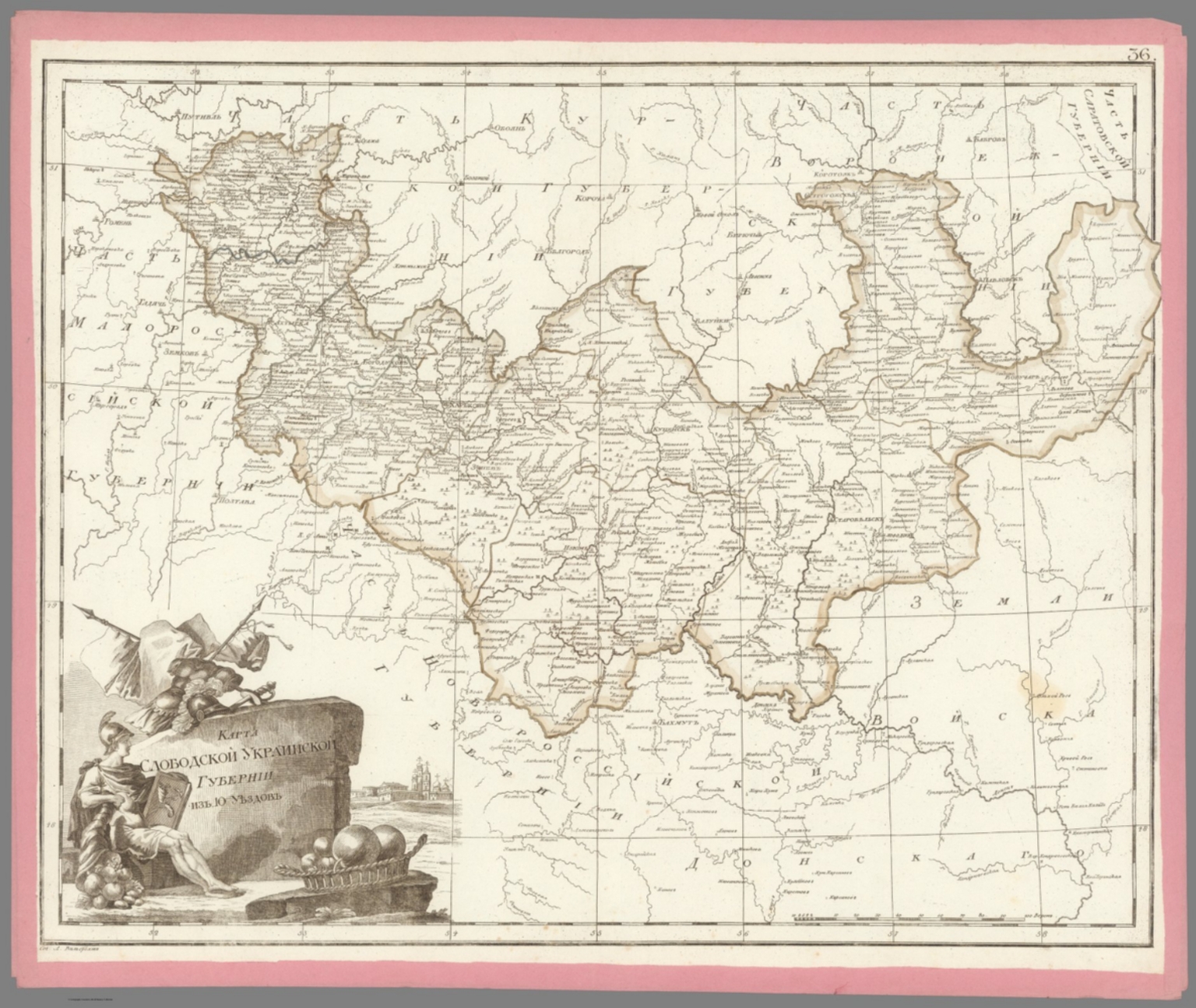
36. 36. Карта Слободской Украинской губернии из 10 уездов. [Map of the Free Ukrainian Province of 10 Districts]. 37. Карта
- Author
-
Aleksandr Mikhailovich Wilbrecht [Александр Михайлович Вильбрехт] (1757 - 1823)
- Subjects
- Russia, Ukraine
- Abstract
"Folio Atlas, but here with Complete Contents contemporarily left unbound and presented as 47 separate copper engraved leaves, each with contemporary pink paper edging. Extremely rare and historically important – the finest Enlightenment Era atlas of the Russian Empire, being the second edition of the work, made on the orders of Czar Paul I to present his new jurisdictional reforms, created by Aleksandr Mikhailovich Wilbrecht, the Chief Geographer and Cartographer to the Imperial Court, from the best sources and surveys, a complete example with 43 maps and 2 preliminary leaves, including a giant 3-sheet general map of the Russian Empire with an important inset depicting the Gulf of Alaska and northern British Columbia coasts, dozens of maps of individual Russian ‘gubernia’ (provinces) of unprecedented accuracy, as well as a map focusing upon Alaska and Kamchatka predicated upon intelligence gained from numerous Russian and British exploring expeditions; all maps beautifully decorated with allegorical cartouches, with text in Russian Cyrillic, published in St. Petersburg by the Czar’s Geographical Department; an extraordinary example clearly never bound, but preserved ‘in plano’ with all leaves with original outline hand colour and contemporary pink paper edging. This work is the finest Enlightenment Era atlas of the Russian Empire (which then included Alaska), and one of the foundational monuments of Russian scientific cartography and geographic intelligence. It is the revised second edition of a work first issued in 1792, and was made by Aleksandr Mikhailovich Wilbrecht, an exceedingly talented geographer, cartographer, mathematician and astronomer, who was the chief geographer and mapmaker to the Imperial Court. This revised edition of the atlas was created on the orders of Czar Paul I especially to show the empire’s new internal jurisdictions which were imposed per his reforms. The folio atlas features 43 maps, including a giant 3-sheet general map of the entire Russian Empire featuring an inset bearing a historically significant map depicting Alaska and much of the coast of British Columbia; individual maps of all of Russia’s first-level jurisdictions predicated upon the best surveys and sources; plus, a large format map of Kamchatka, Alaska and the northern BC Coast, predated upon intelligence from ground-breaking exploring expeditions. All maps are beautifully adored with allegorical cartouches that portray Russia to be a powerful, autocratic state, enlightened by science, culture and commerce, and which vanquishes its enemies. The present example of the atlas is complete, featuring 47 engraved leaves (2 preliminaries, and 43 maps on 45 leaves – the maximum called for); however, it was clearly never bound (the sheets are of dissonant sizes), with the borders of each sheet contemporarily edged with pink paper, allowing the maps to be conveniently enjoyed in plano. The first edition of the atlas, Российский атлас, из сорока четырёх карт состоящий и на сорок два наместничества империю разделяющий [Russian Atlas, consisting of Forty- Four Maps and dividing the Empire into Forty-Two Vice-royalties] (1792), was created by Wilbrecht on the orders of Empress Catherine II the Great (r. 1762-96) to show the new internal jurisdictions of the Russian Empire as imposed by her decree, ‘Institutions for the Management of the Provinces’ (November 7, 1775). Changing the nature and boundaries of the first-level jurisdictions in Russa was not simply a bureaucratic matter, but rather it had a profound impact upon land rights, taxation and economic and infrastructure development. Catherine II’s jurisdictional reforms, which were fully implemented in 1785, saw the empire divided into 38 наместничества (namestnichestva / vice-royalties), 3 provinces, 1 region and 1 special autonomous entity (governed by the Don Cossacks). During the 1790s, Catherine ordered further revisions to the Russian jurisdictions, such that upon her death, in 1796, the empire had 48 namestnichestva. The Wilbrecht atlas was only the second official atlas of the Russian Empire, having been preceded only by the Imperial Academy of Sciences’s Атлас Российской, состоящий из девятнадцати специальных карт… [The Russian Atlas, consisting of Nineteen Special Maps…] (St. Petersburg, 1745), which while a triumph in its time, by the 1790s was considered so outdated as to be practically obsolete. Catherine II’s son and successor, Czar Paul I (r. 1796 - 1801), a clinically insane ruler (who was eventually murdered on the orders of his own son!) absolutely despised his mother and went to great efforts to erase or change virtually anything that he attributed to her rule – including her jurisdictional reforms. He dissolved the 51 namestnichestva and converted them into 42 губе́рния (gubernia / provinces), an act which had significant effects upon public affairs across the empire. Paul I’s jurisdictional reforms naturally made the 1792 Wilbrecht atlas in good measure obsolete. The present 1800 edition of the atlas features largely the same maps and topographical content but sees the plates heavily reworked to show the new jurisdictions, with the titles altered accordingly (ex. on the Title Page and on Map no. 1, Catherine II’s cypher had been replaced by that of Paul I). The atlas fully preserves its important depictions of the Alaska and the northern BC coasts. To clear up any confusion, in the period between 1792 and 1800, Wilbrecht seemingly issued many of the atlas’s constituent maps separately, while groupings of maps were consolidated into what seems to have been atlas factice, such that many surviving examples of the atlas, even some held by elite institutions, are today found incomplete. Thus, the present example is notable for being complete with the maximum number of maps called for. * While the present example of the Wilbrecht Atlas is not bound, it features all the contents as called for, including: 1 Title Page, 1 Contents Register, and 43 maps (1 of which is comprised of 3 un-joined sheets). Some Highlights of the Atlas All the maps in the atlas are of very high quality, and the individual maps of the gubernia are the finest and, in many cases, the first accurate maps of these regions. They are predicated upon a composite of sources, in some cases, good scientific surveys, while accompanied by spectacular iconographic adornment. From an international perspective, the most significant elements are the depictions of the Russian Far East, Russian America (Alaska), and the adjacent coastlines of what is today British Columbia, as the true scientific conception of these regions was then emerging due to on-going exploring expeditions conducted by both Russian and British mariners. Map no. 42B., Восточная часть Иркутской губернии с прилежащими островами и западным берегом Америки [The Eastern Part of the Irkutsk Province with Adjacent Islands and the Western Coast of America], showcases a historically important depiction of Alaska and Kamchatka, derived from expeditions ranging from the 1720s to the 1780s. It is derived from Wilbrecht’s separately issued Карта представляющая открытия Российских мореплавателей на Тихом океане и английского капитана Кукка [Map representing the Discoveries of Russian Navigators in the Pacific Ocean and of the English Captain Cook] (1787), although its projection is quite different. For the littoral areas of Alaska, the map shows a sophisticated awareness of the pre-Cook Russian expeditions of Vitus Bering, Aleksei Chirikov, Pyotyr Krenitsyn and Martin Spanberg, etc., while fully embracing the discoveries from Cook’s Third Voyage (1778-9). The map also presents recent revelations due to the likes of Gerasim Ismailov, who discovered the Kenai Peninsula, and Dimitry Bocharov’s exploration of Kodiak Island and the Alaska Peninsula. In the deep interior (in the modern Northwest Territories), the map shows the discoveries of Samuel Hearn. In a similar vein, the inset on Map No. 1 (the general map of the Russian Empire), Карта представляющая частьзападного берега Америки от полуострова Аляски до залива Нутки положеннаго по новейшим открытиям зделанным Российскими и Английскими мореплавателями в 1784, 1786 и 1787 годах [A Map Representing Part of the Western Coast of America from the Alaska Peninsula to Nootka Bay based on the Latest Discoveries made by Russian and English Navigators in the years 1784, 1786 and 1787], shows the Pacific coast of North America, from the base of the Alaska Peninsula, in the northwest, down the just past Nootka Sound, Vancouver Island, in the southeast. The depiction of the Alaska coast is, in some ways, more advanced than that of Map 42B, especially with respect to its portrayal of places like the Kodiak Archipelago and Prince William Sound. The BC Coast shows an awareness of the discoveries of George Dixon and Nathaniel Portlock (1786-7), especially with regards to the Queen Charlotte Islands (Haida Gwaii) and vicinity. The mapping of north-central Siberia showcased by Map No. 41. Карта Тобольской губернии из 16 уездов [Map of the Tobolsk Province of 16 Counties], is quite interesting, capturing such details as the locations of villages, winter encampments, fortresses, monasteries, mines, salt and fishing works, and the routes of the exploration expeditions of Stepan Malygin (1734-5), Aleksei Ivanovich Skuratov (1734-5), Dmitry Ovtsyn (1735), Muraviev & Pavlov (1737) and Fedor Rozmyslov (1768), while also noting the place where Willem Barents’s expedition wintered in 1596. Aleksandr Mikhailovich Wilbrecht: Leading Russian Cartographer of the Enlightnement Aleksandr Mikhailovich Wilbrecht [Александр Михайлович Вильбрехт] (1757 - 1823) was a cartographer, geographer, astronomer and mathematician, who was the most important mapmaker in the Russian Empire during the late 18th and early 19th centuries, and generally a major force in Enlightenment science in the country. Born to an affluent St. Peterburg family, of partial German ancestry, Wilbrecht studied at the Academy of Arts and the School of the Army Noble Corps. After his graduation, he became a map draughtsman at the Geographical Department of the Imperial Academy of Sciences, before working in more senior roles at the Geographical Department of the Cabinet, the Military Topographic Depot, and the Geographical Department of the Ministry of Education. Wilbrecht came to the personal attention of Catherine the Great and, in 1785, was appointed to head the Higher School of Mathematics of the Imperial Mining School, as well as being the Chief Geographer of the Geographical Department of the Cabinet of Her Imperial Majesty. In these capacities, Wilbrecht’s greatest achievement was the present atlas of the Russian Empire (1792, 1800), with other highlights including his important map of the North Pacific, Карта представляющая открытия Российских мореплавателей на Тихом океане и английского капитана Кукка [A Map Representing the Discoveries of Russian Navigators in the Pacific Ocean and the English Captain Cook] (1787); Карта театра войны Российской империи против шведов сочиненная [Map of the Theatre of War of the Russian Empire against the Swedes, Composed] (1789); and the Подробная карта Российской империи и близлежащих заграничных владений [A Detailed Map of the Russian Empire and nearby Foreign Possessions] (1804, revised 1816), nicknamed the “Stolist Map” a colossal 100-sheet map of the European Russia. As the Russia’s leading geographic educator, Wilbrecht published the important works Новый Атлас или собрание карт всех частей земного шара, почерпнутый из разных сочинителей и напечатанный в Санкт-Петербурге для употребления Юношества в 1793 году при Горном училище [The New Atlas or a Collection of Maps of all Parts of the Globe, drawn from Different Writers and Printed in St. Petersburg for the Use of Youth in 1793 at the Mining School] (1793) and Атлас Российской империи изданной для употребления юношества [Atlas of the Russian Empire published for the Use of the Youth] (1794). Late in life, Wilbrecht became the Director of the Military Topographic Depot, whereupon he introduced top-notch scientific cartography to the Russian Army. A Note on Rarity The atlas, in either the 1792 or 1800 editions, and its intermediate variations, is very rare, especially as complete with all maps as called for in the registers. While there are surely several complete examples of the atlas in various Russian institutions, the only complete example of the 1800 edition we could is trace is held by the National Library of Russia (St. Petersburg). Outside of Russia, the only complete examples of the atlas we can locate are two 1792 editions, held by the Royal Geographical Society and the Beinecke Library (Yale University), although it is possible that there could be a couple more examples that are not properly catalogued online. Incomplete examples of the 1792 edition are held by the Harvard University Library, British Library and the National Library of Scotland, while an incomplete example of the 1800 edition is held by the University of California-Berkeley. The only complete example of the atlas we can trace as having been on the market since 1969 is for an example of the 1792 edition, sold in 2006 at Bonhams’s New York. A substantially incomplete example of the 1792 edition, with only 30 maps, was sold at Sotheby’s London in 2019. (Alexander Johnson/Dasa Pahor, 2023), National Library of Russia (St. Petersburg): К 1-Росс 8/14; cf. [1792 ed.:] 1792: Royal Geographical Society: mr 1.C.112, Beinecke Library (Yale University): 1976 Folio 105; Leo BAGROW, ed. Henry W. Castner, A History of Russian Cartography up to 1800 (Wolfe Island, Ontario: Walker Press, 1975), Part V, pp. 212, 215.
- Published
- 1800
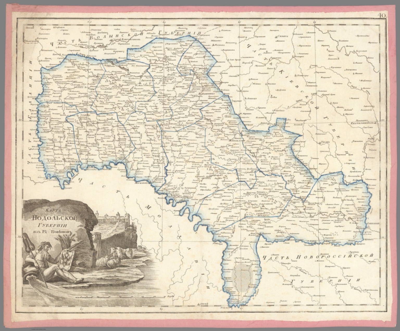
37. 40. Карта Подольской губернии из 12 поветов. [Map of the Podolsk Province of 12 Districts].
- Author
-
Aleksandr Mikhailovich Wilbrecht [Александр Михайлович Вильбрехт] (1757 - 1823)
- Subjects
- Russia
- Abstract
"Folio Atlas, but here with Complete Contents contemporarily left unbound and presented as 47 separate copper engraved leaves, each with contemporary pink paper edging. Extremely rare and historically important – the finest Enlightenment Era atlas of the Russian Empire, being the second edition of the work, made on the orders of Czar Paul I to present his new jurisdictional reforms, created by Aleksandr Mikhailovich Wilbrecht, the Chief Geographer and Cartographer to the Imperial Court, from the best sources and surveys, a complete example with 43 maps and 2 preliminary leaves, including a giant 3-sheet general map of the Russian Empire with an important inset depicting the Gulf of Alaska and northern British Columbia coasts, dozens of maps of individual Russian ‘gubernia’ (provinces) of unprecedented accuracy, as well as a map focusing upon Alaska and Kamchatka predicated upon intelligence gained from numerous Russian and British exploring expeditions; all maps beautifully decorated with allegorical cartouches, with text in Russian Cyrillic, published in St. Petersburg by the Czar’s Geographical Department; an extraordinary example clearly never bound, but preserved ‘in plano’ with all leaves with original outline hand colour and contemporary pink paper edging. This work is the finest Enlightenment Era atlas of the Russian Empire (which then included Alaska), and one of the foundational monuments of Russian scientific cartography and geographic intelligence. It is the revised second edition of a work first issued in 1792, and was made by Aleksandr Mikhailovich Wilbrecht, an exceedingly talented geographer, cartographer, mathematician and astronomer, who was the chief geographer and mapmaker to the Imperial Court. This revised edition of the atlas was created on the orders of Czar Paul I especially to show the empire’s new internal jurisdictions which were imposed per his reforms. The folio atlas features 43 maps, including a giant 3-sheet general map of the entire Russian Empire featuring an inset bearing a historically significant map depicting Alaska and much of the coast of British Columbia; individual maps of all of Russia’s first-level jurisdictions predicated upon the best surveys and sources; plus, a large format map of Kamchatka, Alaska and the northern BC Coast, predated upon intelligence from ground-breaking exploring expeditions. All maps are beautifully adored with allegorical cartouches that portray Russia to be a powerful, autocratic state, enlightened by science, culture and commerce, and which vanquishes its enemies. The present example of the atlas is complete, featuring 47 engraved leaves (2 preliminaries, and 43 maps on 45 leaves – the maximum called for); however, it was clearly never bound (the sheets are of dissonant sizes), with the borders of each sheet contemporarily edged with pink paper, allowing the maps to be conveniently enjoyed in plano. The first edition of the atlas, Российский атлас, из сорока четырёх карт состоящий и на сорок два наместничества империю разделяющий [Russian Atlas, consisting of Forty- Four Maps and dividing the Empire into Forty-Two Vice-royalties] (1792), was created by Wilbrecht on the orders of Empress Catherine II the Great (r. 1762-96) to show the new internal jurisdictions of the Russian Empire as imposed by her decree, ‘Institutions for the Management of the Provinces’ (November 7, 1775). Changing the nature and boundaries of the first-level jurisdictions in Russa was not simply a bureaucratic matter, but rather it had a profound impact upon land rights, taxation and economic and infrastructure development. Catherine II’s jurisdictional reforms, which were fully implemented in 1785, saw the empire divided into 38 наместничества (namestnichestva / vice-royalties), 3 provinces, 1 region and 1 special autonomous entity (governed by the Don Cossacks). During the 1790s, Catherine ordered further revisions to the Russian jurisdictions, such that upon her death, in 1796, the empire had 48 namestnichestva. The Wilbrecht atlas was only the second official atlas of the Russian Empire, having been preceded only by the Imperial Academy of Sciences’s Атлас Российской, состоящий из девятнадцати специальных карт… [The Russian Atlas, consisting of Nineteen Special Maps…] (St. Petersburg, 1745), which while a triumph in its time, by the 1790s was considered so outdated as to be practically obsolete. Catherine II’s son and successor, Czar Paul I (r. 1796 - 1801), a clinically insane ruler (who was eventually murdered on the orders of his own son!) absolutely despised his mother and went to great efforts to erase or change virtually anything that he attributed to her rule – including her jurisdictional reforms. He dissolved the 51 namestnichestva and converted them into 42 губе́рния (gubernia / provinces), an act which had significant effects upon public affairs across the empire. Paul I’s jurisdictional reforms naturally made the 1792 Wilbrecht atlas in good measure obsolete. The present 1800 edition of the atlas features largely the same maps and topographical content but sees the plates heavily reworked to show the new jurisdictions, with the titles altered accordingly (ex. on the Title Page and on Map no. 1, Catherine II’s cypher had been replaced by that of Paul I). The atlas fully preserves its important depictions of the Alaska and the northern BC coasts. To clear up any confusion, in the period between 1792 and 1800, Wilbrecht seemingly issued many of the atlas’s constituent maps separately, while groupings of maps were consolidated into what seems to have been atlas factice, such that many surviving examples of the atlas, even some held by elite institutions, are today found incomplete. Thus, the present example is notable for being complete with the maximum number of maps called for. * While the present example of the Wilbrecht Atlas is not bound, it features all the contents as called for, including: 1 Title Page, 1 Contents Register, and 43 maps (1 of which is comprised of 3 un-joined sheets). Some Highlights of the Atlas All the maps in the atlas are of very high quality, and the individual maps of the gubernia are the finest and, in many cases, the first accurate maps of these regions. They are predicated upon a composite of sources, in some cases, good scientific surveys, while accompanied by spectacular iconographic adornment. From an international perspective, the most significant elements are the depictions of the Russian Far East, Russian America (Alaska), and the adjacent coastlines of what is today British Columbia, as the true scientific conception of these regions was then emerging due to on-going exploring expeditions conducted by both Russian and British mariners. Map no. 42B., Восточная часть Иркутской губернии с прилежащими островами и западным берегом Америки [The Eastern Part of the Irkutsk Province with Adjacent Islands and the Western Coast of America], showcases a historically important depiction of Alaska and Kamchatka, derived from expeditions ranging from the 1720s to the 1780s. It is derived from Wilbrecht’s separately issued Карта представляющая открытия Российских мореплавателей на Тихом океане и английского капитана Кукка [Map representing the Discoveries of Russian Navigators in the Pacific Ocean and of the English Captain Cook] (1787), although its projection is quite different. For the littoral areas of Alaska, the map shows a sophisticated awareness of the pre-Cook Russian expeditions of Vitus Bering, Aleksei Chirikov, Pyotyr Krenitsyn and Martin Spanberg, etc., while fully embracing the discoveries from Cook’s Third Voyage (1778-9). The map also presents recent revelations due to the likes of Gerasim Ismailov, who discovered the Kenai Peninsula, and Dimitry Bocharov’s exploration of Kodiak Island and the Alaska Peninsula. In the deep interior (in the modern Northwest Territories), the map shows the discoveries of Samuel Hearn. In a similar vein, the inset on Map No. 1 (the general map of the Russian Empire), Карта представляющая частьзападного берега Америки от полуострова Аляски до залива Нутки положеннаго по новейшим открытиям зделанным Российскими и Английскими мореплавателями в 1784, 1786 и 1787 годах [A Map Representing Part of the Western Coast of America from the Alaska Peninsula to Nootka Bay based on the Latest Discoveries made by Russian and English Navigators in the years 1784, 1786 and 1787], shows the Pacific coast of North America, from the base of the Alaska Peninsula, in the northwest, down the just past Nootka Sound, Vancouver Island, in the southeast. The depiction of the Alaska coast is, in some ways, more advanced than that of Map 42B, especially with respect to its portrayal of places like the Kodiak Archipelago and Prince William Sound. The BC Coast shows an awareness of the discoveries of George Dixon and Nathaniel Portlock (1786-7), especially with regards to the Queen Charlotte Islands (Haida Gwaii) and vicinity. The mapping of north-central Siberia showcased by Map No. 41. Карта Тобольской губернии из 16 уездов [Map of the Tobolsk Province of 16 Counties], is quite interesting, capturing such details as the locations of villages, winter encampments, fortresses, monasteries, mines, salt and fishing works, and the routes of the exploration expeditions of Stepan Malygin (1734-5), Aleksei Ivanovich Skuratov (1734-5), Dmitry Ovtsyn (1735), Muraviev & Pavlov (1737) and Fedor Rozmyslov (1768), while also noting the place where Willem Barents’s expedition wintered in 1596. Aleksandr Mikhailovich Wilbrecht: Leading Russian Cartographer of the Enlightnement Aleksandr Mikhailovich Wilbrecht [Александр Михайлович Вильбрехт] (1757 - 1823) was a cartographer, geographer, astronomer and mathematician, who was the most important mapmaker in the Russian Empire during the late 18th and early 19th centuries, and generally a major force in Enlightenment science in the country. Born to an affluent St. Peterburg family, of partial German ancestry, Wilbrecht studied at the Academy of Arts and the School of the Army Noble Corps. After his graduation, he became a map draughtsman at the Geographical Department of the Imperial Academy of Sciences, before working in more senior roles at the Geographical Department of the Cabinet, the Military Topographic Depot, and the Geographical Department of the Ministry of Education. Wilbrecht came to the personal attention of Catherine the Great and, in 1785, was appointed to head the Higher School of Mathematics of the Imperial Mining School, as well as being the Chief Geographer of the Geographical Department of the Cabinet of Her Imperial Majesty. In these capacities, Wilbrecht’s greatest achievement was the present atlas of the Russian Empire (1792, 1800), with other highlights including his important map of the North Pacific, Карта представляющая открытия Российских мореплавателей на Тихом океане и английского капитана Кукка [A Map Representing the Discoveries of Russian Navigators in the Pacific Ocean and the English Captain Cook] (1787); Карта театра войны Российской империи против шведов сочиненная [Map of the Theatre of War of the Russian Empire against the Swedes, Composed] (1789); and the Подробная карта Российской империи и близлежащих заграничных владений [A Detailed Map of the Russian Empire and nearby Foreign Possessions] (1804, revised 1816), nicknamed the “Stolist Map” a colossal 100-sheet map of the European Russia. As the Russia’s leading geographic educator, Wilbrecht published the important works Новый Атлас или собрание карт всех частей земного шара, почерпнутый из разных сочинителей и напечатанный в Санкт-Петербурге для употребления Юношества в 1793 году при Горном училище [The New Atlas or a Collection of Maps of all Parts of the Globe, drawn from Different Writers and Printed in St. Petersburg for the Use of Youth in 1793 at the Mining School] (1793) and Атлас Российской империи изданной для употребления юношества [Atlas of the Russian Empire published for the Use of the Youth] (1794). Late in life, Wilbrecht became the Director of the Military Topographic Depot, whereupon he introduced top-notch scientific cartography to the Russian Army. A Note on Rarity The atlas, in either the 1792 or 1800 editions, and its intermediate variations, is very rare, especially as complete with all maps as called for in the registers. While there are surely several complete examples of the atlas in various Russian institutions, the only complete example of the 1800 edition we could is trace is held by the National Library of Russia (St. Petersburg). Outside of Russia, the only complete examples of the atlas we can locate are two 1792 editions, held by the Royal Geographical Society and the Beinecke Library (Yale University), although it is possible that there could be a couple more examples that are not properly catalogued online. Incomplete examples of the 1792 edition are held by the Harvard University Library, British Library and the National Library of Scotland, while an incomplete example of the 1800 edition is held by the University of California-Berkeley. The only complete example of the atlas we can trace as having been on the market since 1969 is for an example of the 1792 edition, sold in 2006 at Bonhams’s New York. A substantially incomplete example of the 1792 edition, with only 30 maps, was sold at Sotheby’s London in 2019. (Alexander Johnson/Dasa Pahor, 2023), National Library of Russia (St. Petersburg): К 1-Росс 8/14; cf. [1792 ed.:] 1792: Royal Geographical Society: mr 1.C.112, Beinecke Library (Yale University): 1976 Folio 105; Leo BAGROW, ed. Henry W. Castner, A History of Russian Cartography up to 1800 (Wolfe Island, Ontario: Walker Press, 1975), Part V, pp. 212, 215.
- Published
- 1800
38. 39. Карта Киевской губернии из 8 уездов. [Map of the Kyiv Province of 8 Districts].
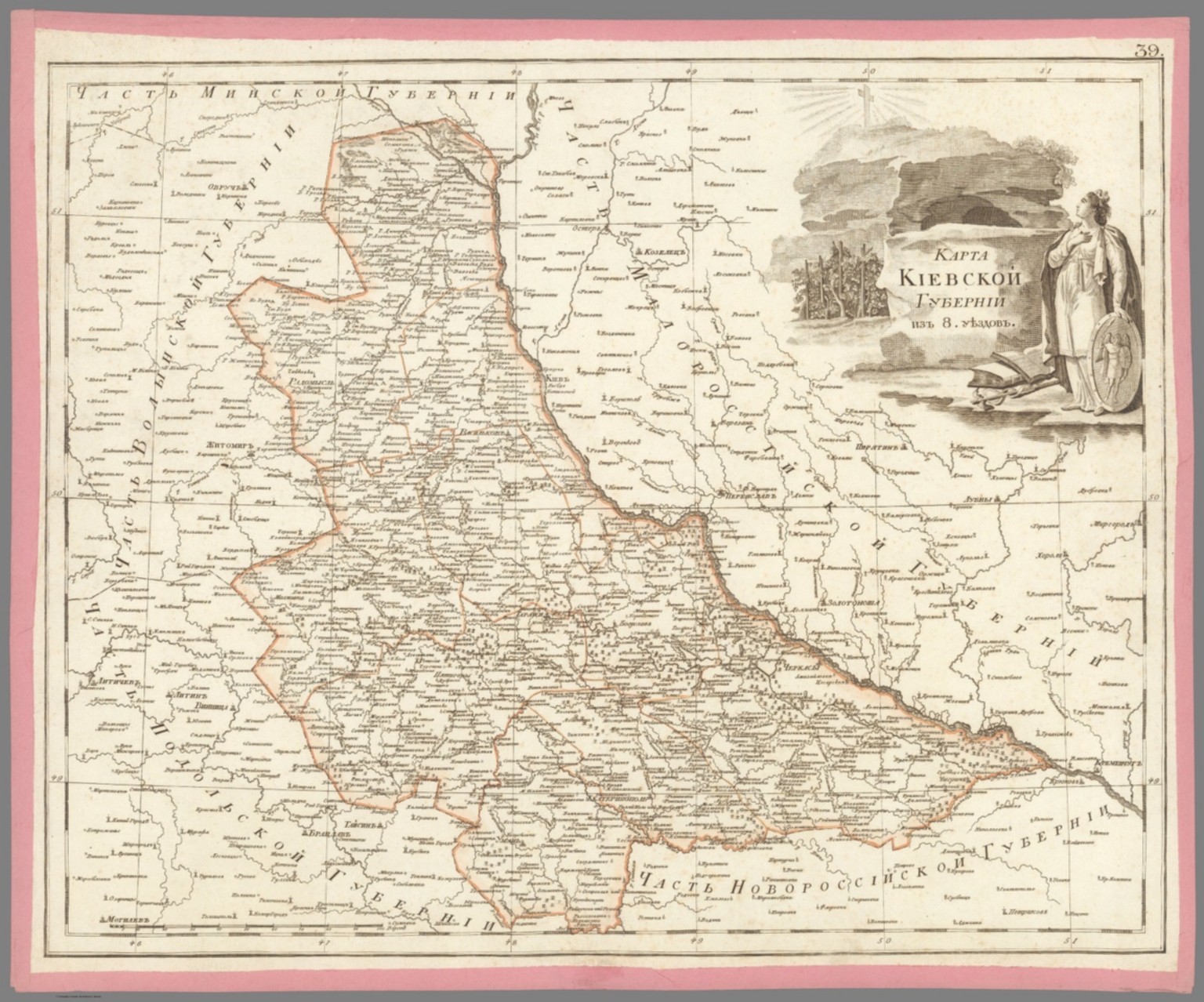
- Author
-
Aleksandr Mikhailovich Wilbrecht [Александр Михайлович Вильбрехт] (1757 - 1823)
- Subjects
- Kiev (Ukraine), Russia
- Abstract
"Folio Atlas, but here with Complete Contents contemporarily left unbound and presented as 47 separate copper engraved leaves, each with contemporary pink paper edging. Extremely rare and historically important – the finest Enlightenment Era atlas of the Russian Empire, being the second edition of the work, made on the orders of Czar Paul I to present his new jurisdictional reforms, created by Aleksandr Mikhailovich Wilbrecht, the Chief Geographer and Cartographer to the Imperial Court, from the best sources and surveys, a complete example with 43 maps and 2 preliminary leaves, including a giant 3-sheet general map of the Russian Empire with an important inset depicting the Gulf of Alaska and northern British Columbia coasts, dozens of maps of individual Russian ‘gubernia’ (provinces) of unprecedented accuracy, as well as a map focusing upon Alaska and Kamchatka predicated upon intelligence gained from numerous Russian and British exploring expeditions; all maps beautifully decorated with allegorical cartouches, with text in Russian Cyrillic, published in St. Petersburg by the Czar’s Geographical Department; an extraordinary example clearly never bound, but preserved ‘in plano’ with all leaves with original outline hand colour and contemporary pink paper edging. This work is the finest Enlightenment Era atlas of the Russian Empire (which then included Alaska), and one of the foundational monuments of Russian scientific cartography and geographic intelligence. It is the revised second edition of a work first issued in 1792, and was made by Aleksandr Mikhailovich Wilbrecht, an exceedingly talented geographer, cartographer, mathematician and astronomer, who was the chief geographer and mapmaker to the Imperial Court. This revised edition of the atlas was created on the orders of Czar Paul I especially to show the empire’s new internal jurisdictions which were imposed per his reforms. The folio atlas features 43 maps, including a giant 3-sheet general map of the entire Russian Empire featuring an inset bearing a historically significant map depicting Alaska and much of the coast of British Columbia; individual maps of all of Russia’s first-level jurisdictions predicated upon the best surveys and sources; plus, a large format map of Kamchatka, Alaska and the northern BC Coast, predated upon intelligence from ground-breaking exploring expeditions. All maps are beautifully adored with allegorical cartouches that portray Russia to be a powerful, autocratic state, enlightened by science, culture and commerce, and which vanquishes its enemies. The present example of the atlas is complete, featuring 47 engraved leaves (2 preliminaries, and 43 maps on 45 leaves – the maximum called for); however, it was clearly never bound (the sheets are of dissonant sizes), with the borders of each sheet contemporarily edged with pink paper, allowing the maps to be conveniently enjoyed in plano. The first edition of the atlas, Российский атлас, из сорока четырёх карт состоящий и на сорок два наместничества империю разделяющий [Russian Atlas, consisting of Forty- Four Maps and dividing the Empire into Forty-Two Vice-royalties] (1792), was created by Wilbrecht on the orders of Empress Catherine II the Great (r. 1762-96) to show the new internal jurisdictions of the Russian Empire as imposed by her decree, ‘Institutions for the Management of the Provinces’ (November 7, 1775). Changing the nature and boundaries of the first-level jurisdictions in Russa was not simply a bureaucratic matter, but rather it had a profound impact upon land rights, taxation and economic and infrastructure development. Catherine II’s jurisdictional reforms, which were fully implemented in 1785, saw the empire divided into 38 наместничества (namestnichestva / vice-royalties), 3 provinces, 1 region and 1 special autonomous entity (governed by the Don Cossacks). During the 1790s, Catherine ordered further revisions to the Russian jurisdictions, such that upon her death, in 1796, the empire had 48 namestnichestva. The Wilbrecht atlas was only the second official atlas of the Russian Empire, having been preceded only by the Imperial Academy of Sciences’s Атлас Российской, состоящий из девятнадцати специальных карт… [The Russian Atlas, consisting of Nineteen Special Maps…] (St. Petersburg, 1745), which while a triumph in its time, by the 1790s was considered so outdated as to be practically obsolete. Catherine II’s son and successor, Czar Paul I (r. 1796 - 1801), a clinically insane ruler (who was eventually murdered on the orders of his own son!) absolutely despised his mother and went to great efforts to erase or change virtually anything that he attributed to her rule – including her jurisdictional reforms. He dissolved the 51 namestnichestva and converted them into 42 губе́рния (gubernia / provinces), an act which had significant effects upon public affairs across the empire. Paul I’s jurisdictional reforms naturally made the 1792 Wilbrecht atlas in good measure obsolete. The present 1800 edition of the atlas features largely the same maps and topographical content but sees the plates heavily reworked to show the new jurisdictions, with the titles altered accordingly (ex. on the Title Page and on Map no. 1, Catherine II’s cypher had been replaced by that of Paul I). The atlas fully preserves its important depictions of the Alaska and the northern BC coasts. To clear up any confusion, in the period between 1792 and 1800, Wilbrecht seemingly issued many of the atlas’s constituent maps separately, while groupings of maps were consolidated into what seems to have been atlas factice, such that many surviving examples of the atlas, even some held by elite institutions, are today found incomplete. Thus, the present example is notable for being complete with the maximum number of maps called for. * While the present example of the Wilbrecht Atlas is not bound, it features all the contents as called for, including: 1 Title Page, 1 Contents Register, and 43 maps (1 of which is comprised of 3 un-joined sheets). Some Highlights of the Atlas All the maps in the atlas are of very high quality, and the individual maps of the gubernia are the finest and, in many cases, the first accurate maps of these regions. They are predicated upon a composite of sources, in some cases, good scientific surveys, while accompanied by spectacular iconographic adornment. From an international perspective, the most significant elements are the depictions of the Russian Far East, Russian America (Alaska), and the adjacent coastlines of what is today British Columbia, as the true scientific conception of these regions was then emerging due to on-going exploring expeditions conducted by both Russian and British mariners. Map no. 42B., Восточная часть Иркутской губернии с прилежащими островами и западным берегом Америки [The Eastern Part of the Irkutsk Province with Adjacent Islands and the Western Coast of America], showcases a historically important depiction of Alaska and Kamchatka, derived from expeditions ranging from the 1720s to the 1780s. It is derived from Wilbrecht’s separately issued Карта представляющая открытия Российских мореплавателей на Тихом океане и английского капитана Кукка [Map representing the Discoveries of Russian Navigators in the Pacific Ocean and of the English Captain Cook] (1787), although its projection is quite different. For the littoral areas of Alaska, the map shows a sophisticated awareness of the pre-Cook Russian expeditions of Vitus Bering, Aleksei Chirikov, Pyotyr Krenitsyn and Martin Spanberg, etc., while fully embracing the discoveries from Cook’s Third Voyage (1778-9). The map also presents recent revelations due to the likes of Gerasim Ismailov, who discovered the Kenai Peninsula, and Dimitry Bocharov’s exploration of Kodiak Island and the Alaska Peninsula. In the deep interior (in the modern Northwest Territories), the map shows the discoveries of Samuel Hearn. In a similar vein, the inset on Map No. 1 (the general map of the Russian Empire), Карта представляющая частьзападного берега Америки от полуострова Аляски до залива Нутки положеннаго по новейшим открытиям зделанным Российскими и Английскими мореплавателями в 1784, 1786 и 1787 годах [A Map Representing Part of the Western Coast of America from the Alaska Peninsula to Nootka Bay based on the Latest Discoveries made by Russian and English Navigators in the years 1784, 1786 and 1787], shows the Pacific coast of North America, from the base of the Alaska Peninsula, in the northwest, down the just past Nootka Sound, Vancouver Island, in the southeast. The depiction of the Alaska coast is, in some ways, more advanced than that of Map 42B, especially with respect to its portrayal of places like the Kodiak Archipelago and Prince William Sound. The BC Coast shows an awareness of the discoveries of George Dixon and Nathaniel Portlock (1786-7), especially with regards to the Queen Charlotte Islands (Haida Gwaii) and vicinity. The mapping of north-central Siberia showcased by Map No. 41. Карта Тобольской губернии из 16 уездов [Map of the Tobolsk Province of 16 Counties], is quite interesting, capturing such details as the locations of villages, winter encampments, fortresses, monasteries, mines, salt and fishing works, and the routes of the exploration expeditions of Stepan Malygin (1734-5), Aleksei Ivanovich Skuratov (1734-5), Dmitry Ovtsyn (1735), Muraviev & Pavlov (1737) and Fedor Rozmyslov (1768), while also noting the place where Willem Barents’s expedition wintered in 1596. Aleksandr Mikhailovich Wilbrecht: Leading Russian Cartographer of the Enlightnement Aleksandr Mikhailovich Wilbrecht [Александр Михайлович Вильбрехт] (1757 - 1823) was a cartographer, geographer, astronomer and mathematician, who was the most important mapmaker in the Russian Empire during the late 18th and early 19th centuries, and generally a major force in Enlightenment science in the country. Born to an affluent St. Peterburg family, of partial German ancestry, Wilbrecht studied at the Academy of Arts and the School of the Army Noble Corps. After his graduation, he became a map draughtsman at the Geographical Department of the Imperial Academy of Sciences, before working in more senior roles at the Geographical Department of the Cabinet, the Military Topographic Depot, and the Geographical Department of the Ministry of Education. Wilbrecht came to the personal attention of Catherine the Great and, in 1785, was appointed to head the Higher School of Mathematics of the Imperial Mining School, as well as being the Chief Geographer of the Geographical Department of the Cabinet of Her Imperial Majesty. In these capacities, Wilbrecht’s greatest achievement was the present atlas of the Russian Empire (1792, 1800), with other highlights including his important map of the North Pacific, Карта представляющая открытия Российских мореплавателей на Тихом океане и английского капитана Кукка [A Map Representing the Discoveries of Russian Navigators in the Pacific Ocean and the English Captain Cook] (1787); Карта театра войны Российской империи против шведов сочиненная [Map of the Theatre of War of the Russian Empire against the Swedes, Composed] (1789); and the Подробная карта Российской империи и близлежащих заграничных владений [A Detailed Map of the Russian Empire and nearby Foreign Possessions] (1804, revised 1816), nicknamed the “Stolist Map” a colossal 100-sheet map of the European Russia. As the Russia’s leading geographic educator, Wilbrecht published the important works Новый Атлас или собрание карт всех частей земного шара, почерпнутый из разных сочинителей и напечатанный в Санкт-Петербурге для употребления Юношества в 1793 году при Горном училище [The New Atlas or a Collection of Maps of all Parts of the Globe, drawn from Different Writers and Printed in St. Petersburg for the Use of Youth in 1793 at the Mining School] (1793) and Атлас Российской империи изданной для употребления юношества [Atlas of the Russian Empire published for the Use of the Youth] (1794). Late in life, Wilbrecht became the Director of the Military Topographic Depot, whereupon he introduced top-notch scientific cartography to the Russian Army. A Note on Rarity The atlas, in either the 1792 or 1800 editions, and its intermediate variations, is very rare, especially as complete with all maps as called for in the registers. While there are surely several complete examples of the atlas in various Russian institutions, the only complete example of the 1800 edition we could is trace is held by the National Library of Russia (St. Petersburg). Outside of Russia, the only complete examples of the atlas we can locate are two 1792 editions, held by the Royal Geographical Society and the Beinecke Library (Yale University), although it is possible that there could be a couple more examples that are not properly catalogued online. Incomplete examples of the 1792 edition are held by the Harvard University Library, British Library and the National Library of Scotland, while an incomplete example of the 1800 edition is held by the University of California-Berkeley. The only complete example of the atlas we can trace as having been on the market since 1969 is for an example of the 1792 edition, sold in 2006 at Bonhams’s New York. A substantially incomplete example of the 1792 edition, with only 30 maps, was sold at Sotheby’s London in 2019. (Alexander Johnson/Dasa Pahor, 2023), National Library of Russia (St. Petersburg): К 1-Росс 8/14; cf. [1792 ed.:] 1792: Royal Geographical Society: mr 1.C.112, Beinecke Library (Yale University): 1976 Folio 105; Leo BAGROW, ed. Henry W. Castner, A History of Russian Cartography up to 1800 (Wolfe Island, Ontario: Walker Press, 1975), Part V, pp. 212, 215.
- Published
- 1800
39. 35. Карта Воронежской губернии из 9 уездов. [Map of the Voronezh Province of 9 Districts].
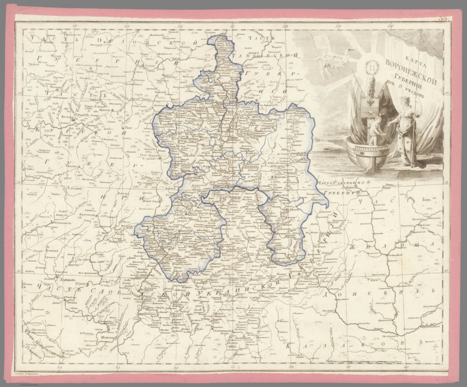
- Author
-
Aleksandr Mikhailovich Wilbrecht [Александр Михайлович Вильбрехт] (1757 - 1823)
- Subjects
- Russia
- Abstract
"Folio Atlas, but here with Complete Contents contemporarily left unbound and presented as 47 separate copper engraved leaves, each with contemporary pink paper edging. Extremely rare and historically important – the finest Enlightenment Era atlas of the Russian Empire, being the second edition of the work, made on the orders of Czar Paul I to present his new jurisdictional reforms, created by Aleksandr Mikhailovich Wilbrecht, the Chief Geographer and Cartographer to the Imperial Court, from the best sources and surveys, a complete example with 43 maps and 2 preliminary leaves, including a giant 3-sheet general map of the Russian Empire with an important inset depicting the Gulf of Alaska and northern British Columbia coasts, dozens of maps of individual Russian ‘gubernia’ (provinces) of unprecedented accuracy, as well as a map focusing upon Alaska and Kamchatka predicated upon intelligence gained from numerous Russian and British exploring expeditions; all maps beautifully decorated with allegorical cartouches, with text in Russian Cyrillic, published in St. Petersburg by the Czar’s Geographical Department; an extraordinary example clearly never bound, but preserved ‘in plano’ with all leaves with original outline hand colour and contemporary pink paper edging. This work is the finest Enlightenment Era atlas of the Russian Empire (which then included Alaska), and one of the foundational monuments of Russian scientific cartography and geographic intelligence. It is the revised second edition of a work first issued in 1792, and was made by Aleksandr Mikhailovich Wilbrecht, an exceedingly talented geographer, cartographer, mathematician and astronomer, who was the chief geographer and mapmaker to the Imperial Court. This revised edition of the atlas was created on the orders of Czar Paul I especially to show the empire’s new internal jurisdictions which were imposed per his reforms. The folio atlas features 43 maps, including a giant 3-sheet general map of the entire Russian Empire featuring an inset bearing a historically significant map depicting Alaska and much of the coast of British Columbia; individual maps of all of Russia’s first-level jurisdictions predicated upon the best surveys and sources; plus, a large format map of Kamchatka, Alaska and the northern BC Coast, predated upon intelligence from ground-breaking exploring expeditions. All maps are beautifully adored with allegorical cartouches that portray Russia to be a powerful, autocratic state, enlightened by science, culture and commerce, and which vanquishes its enemies. The present example of the atlas is complete, featuring 47 engraved leaves (2 preliminaries, and 43 maps on 45 leaves – the maximum called for); however, it was clearly never bound (the sheets are of dissonant sizes), with the borders of each sheet contemporarily edged with pink paper, allowing the maps to be conveniently enjoyed in plano. The first edition of the atlas, Российский атлас, из сорока четырёх карт состоящий и на сорок два наместничества империю разделяющий [Russian Atlas, consisting of Forty- Four Maps and dividing the Empire into Forty-Two Vice-royalties] (1792), was created by Wilbrecht on the orders of Empress Catherine II the Great (r. 1762-96) to show the new internal jurisdictions of the Russian Empire as imposed by her decree, ‘Institutions for the Management of the Provinces’ (November 7, 1775). Changing the nature and boundaries of the first-level jurisdictions in Russa was not simply a bureaucratic matter, but rather it had a profound impact upon land rights, taxation and economic and infrastructure development. Catherine II’s jurisdictional reforms, which were fully implemented in 1785, saw the empire divided into 38 наместничества (namestnichestva / vice-royalties), 3 provinces, 1 region and 1 special autonomous entity (governed by the Don Cossacks). During the 1790s, Catherine ordered further revisions to the Russian jurisdictions, such that upon her death, in 1796, the empire had 48 namestnichestva. The Wilbrecht atlas was only the second official atlas of the Russian Empire, having been preceded only by the Imperial Academy of Sciences’s Атлас Российской, состоящий из девятнадцати специальных карт… [The Russian Atlas, consisting of Nineteen Special Maps…] (St. Petersburg, 1745), which while a triumph in its time, by the 1790s was considered so outdated as to be practically obsolete. Catherine II’s son and successor, Czar Paul I (r. 1796 - 1801), a clinically insane ruler (who was eventually murdered on the orders of his own son!) absolutely despised his mother and went to great efforts to erase or change virtually anything that he attributed to her rule – including her jurisdictional reforms. He dissolved the 51 namestnichestva and converted them into 42 губе́рния (gubernia / provinces), an act which had significant effects upon public affairs across the empire. Paul I’s jurisdictional reforms naturally made the 1792 Wilbrecht atlas in good measure obsolete. The present 1800 edition of the atlas features largely the same maps and topographical content but sees the plates heavily reworked to show the new jurisdictions, with the titles altered accordingly (ex. on the Title Page and on Map no. 1, Catherine II’s cypher had been replaced by that of Paul I). The atlas fully preserves its important depictions of the Alaska and the northern BC coasts. To clear up any confusion, in the period between 1792 and 1800, Wilbrecht seemingly issued many of the atlas’s constituent maps separately, while groupings of maps were consolidated into what seems to have been atlas factice, such that many surviving examples of the atlas, even some held by elite institutions, are today found incomplete. Thus, the present example is notable for being complete with the maximum number of maps called for. * While the present example of the Wilbrecht Atlas is not bound, it features all the contents as called for, including: 1 Title Page, 1 Contents Register, and 43 maps (1 of which is comprised of 3 un-joined sheets). Some Highlights of the Atlas All the maps in the atlas are of very high quality, and the individual maps of the gubernia are the finest and, in many cases, the first accurate maps of these regions. They are predicated upon a composite of sources, in some cases, good scientific surveys, while accompanied by spectacular iconographic adornment. From an international perspective, the most significant elements are the depictions of the Russian Far East, Russian America (Alaska), and the adjacent coastlines of what is today British Columbia, as the true scientific conception of these regions was then emerging due to on-going exploring expeditions conducted by both Russian and British mariners. Map no. 42B., Восточная часть Иркутской губернии с прилежащими островами и западным берегом Америки [The Eastern Part of the Irkutsk Province with Adjacent Islands and the Western Coast of America], showcases a historically important depiction of Alaska and Kamchatka, derived from expeditions ranging from the 1720s to the 1780s. It is derived from Wilbrecht’s separately issued Карта представляющая открытия Российских мореплавателей на Тихом океане и английского капитана Кукка [Map representing the Discoveries of Russian Navigators in the Pacific Ocean and of the English Captain Cook] (1787), although its projection is quite different. For the littoral areas of Alaska, the map shows a sophisticated awareness of the pre-Cook Russian expeditions of Vitus Bering, Aleksei Chirikov, Pyotyr Krenitsyn and Martin Spanberg, etc., while fully embracing the discoveries from Cook’s Third Voyage (1778-9). The map also presents recent revelations due to the likes of Gerasim Ismailov, who discovered the Kenai Peninsula, and Dimitry Bocharov’s exploration of Kodiak Island and the Alaska Peninsula. In the deep interior (in the modern Northwest Territories), the map shows the discoveries of Samuel Hearn. In a similar vein, the inset on Map No. 1 (the general map of the Russian Empire), Карта представляющая частьзападного берега Америки от полуострова Аляски до залива Нутки положеннаго по новейшим открытиям зделанным Российскими и Английскими мореплавателями в 1784, 1786 и 1787 годах [A Map Representing Part of the Western Coast of America from the Alaska Peninsula to Nootka Bay based on the Latest Discoveries made by Russian and English Navigators in the years 1784, 1786 and 1787], shows the Pacific coast of North America, from the base of the Alaska Peninsula, in the northwest, down the just past Nootka Sound, Vancouver Island, in the southeast. The depiction of the Alaska coast is, in some ways, more advanced than that of Map 42B, especially with respect to its portrayal of places like the Kodiak Archipelago and Prince William Sound. The BC Coast shows an awareness of the discoveries of George Dixon and Nathaniel Portlock (1786-7), especially with regards to the Queen Charlotte Islands (Haida Gwaii) and vicinity. The mapping of north-central Siberia showcased by Map No. 41. Карта Тобольской губернии из 16 уездов [Map of the Tobolsk Province of 16 Counties], is quite interesting, capturing such details as the locations of villages, winter encampments, fortresses, monasteries, mines, salt and fishing works, and the routes of the exploration expeditions of Stepan Malygin (1734-5), Aleksei Ivanovich Skuratov (1734-5), Dmitry Ovtsyn (1735), Muraviev & Pavlov (1737) and Fedor Rozmyslov (1768), while also noting the place where Willem Barents’s expedition wintered in 1596. Aleksandr Mikhailovich Wilbrecht: Leading Russian Cartographer of the Enlightnement Aleksandr Mikhailovich Wilbrecht [Александр Михайлович Вильбрехт] (1757 - 1823) was a cartographer, geographer, astronomer and mathematician, who was the most important mapmaker in the Russian Empire during the late 18th and early 19th centuries, and generally a major force in Enlightenment science in the country. Born to an affluent St. Peterburg family, of partial German ancestry, Wilbrecht studied at the Academy of Arts and the School of the Army Noble Corps. After his graduation, he became a map draughtsman at the Geographical Department of the Imperial Academy of Sciences, before working in more senior roles at the Geographical Department of the Cabinet, the Military Topographic Depot, and the Geographical Department of the Ministry of Education. Wilbrecht came to the personal attention of Catherine the Great and, in 1785, was appointed to head the Higher School of Mathematics of the Imperial Mining School, as well as being the Chief Geographer of the Geographical Department of the Cabinet of Her Imperial Majesty. In these capacities, Wilbrecht’s greatest achievement was the present atlas of the Russian Empire (1792, 1800), with other highlights including his important map of the North Pacific, Карта представляющая открытия Российских мореплавателей на Тихом океане и английского капитана Кукка [A Map Representing the Discoveries of Russian Navigators in the Pacific Ocean and the English Captain Cook] (1787); Карта театра войны Российской империи против шведов сочиненная [Map of the Theatre of War of the Russian Empire against the Swedes, Composed] (1789); and the Подробная карта Российской империи и близлежащих заграничных владений [A Detailed Map of the Russian Empire and nearby Foreign Possessions] (1804, revised 1816), nicknamed the “Stolist Map” a colossal 100-sheet map of the European Russia. As the Russia’s leading geographic educator, Wilbrecht published the important works Новый Атлас или собрание карт всех частей земного шара, почерпнутый из разных сочинителей и напечатанный в Санкт-Петербурге для употребления Юношества в 1793 году при Горном училище [The New Atlas or a Collection of Maps of all Parts of the Globe, drawn from Different Writers and Printed in St. Petersburg for the Use of Youth in 1793 at the Mining School] (1793) and Атлас Российской империи изданной для употребления юношества [Atlas of the Russian Empire published for the Use of the Youth] (1794). Late in life, Wilbrecht became the Director of the Military Topographic Depot, whereupon he introduced top-notch scientific cartography to the Russian Army. A Note on Rarity The atlas, in either the 1792 or 1800 editions, and its intermediate variations, is very rare, especially as complete with all maps as called for in the registers. While there are surely several complete examples of the atlas in various Russian institutions, the only complete example of the 1800 edition we could is trace is held by the National Library of Russia (St. Petersburg). Outside of Russia, the only complete examples of the atlas we can locate are two 1792 editions, held by the Royal Geographical Society and the Beinecke Library (Yale University), although it is possible that there could be a couple more examples that are not properly catalogued online. Incomplete examples of the 1792 edition are held by the Harvard University Library, British Library and the National Library of Scotland, while an incomplete example of the 1800 edition is held by the University of California-Berkeley. The only complete example of the atlas we can trace as having been on the market since 1969 is for an example of the 1792 edition, sold in 2006 at Bonhams’s New York. A substantially incomplete example of the 1792 edition, with only 30 maps, was sold at Sotheby’s London in 2019. (Alexander Johnson/Dasa Pahor, 2023), National Library of Russia (St. Petersburg): К 1-Росс 8/14; cf. [1792 ed.:] 1792: Royal Geographical Society: mr 1.C.112, Beinecke Library (Yale University): 1976 Folio 105; Leo BAGROW, ed. Henry W. Castner, A History of Russian Cartography up to 1800 (Wolfe Island, Ontario: Walker Press, 1975), Part V, pp. 212, 215.
- Published
- 1800
40. 34. Карта Тамбовской губернии из 10 уездов. [Map of the Tambov Province of 10 Districts].
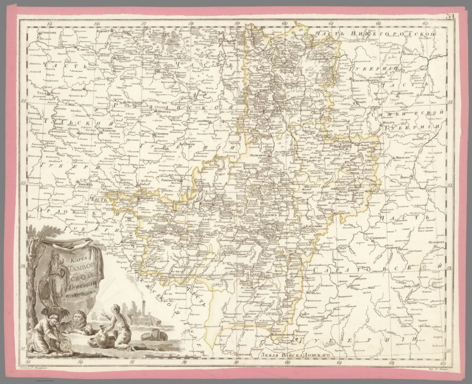
- Author
-
Aleksandr Mikhailovich Wilbrecht [Александр Михайлович Вильбрехт] (1757 - 1823)
- Subjects
- Russia
- Abstract
"Folio Atlas, but here with Complete Contents contemporarily left unbound and presented as 47 separate copper engraved leaves, each with contemporary pink paper edging. Extremely rare and historically important – the finest Enlightenment Era atlas of the Russian Empire, being the second edition of the work, made on the orders of Czar Paul I to present his new jurisdictional reforms, created by Aleksandr Mikhailovich Wilbrecht, the Chief Geographer and Cartographer to the Imperial Court, from the best sources and surveys, a complete example with 43 maps and 2 preliminary leaves, including a giant 3-sheet general map of the Russian Empire with an important inset depicting the Gulf of Alaska and northern British Columbia coasts, dozens of maps of individual Russian ‘gubernia’ (provinces) of unprecedented accuracy, as well as a map focusing upon Alaska and Kamchatka predicated upon intelligence gained from numerous Russian and British exploring expeditions; all maps beautifully decorated with allegorical cartouches, with text in Russian Cyrillic, published in St. Petersburg by the Czar’s Geographical Department; an extraordinary example clearly never bound, but preserved ‘in plano’ with all leaves with original outline hand colour and contemporary pink paper edging. This work is the finest Enlightenment Era atlas of the Russian Empire (which then included Alaska), and one of the foundational monuments of Russian scientific cartography and geographic intelligence. It is the revised second edition of a work first issued in 1792, and was made by Aleksandr Mikhailovich Wilbrecht, an exceedingly talented geographer, cartographer, mathematician and astronomer, who was the chief geographer and mapmaker to the Imperial Court. This revised edition of the atlas was created on the orders of Czar Paul I especially to show the empire’s new internal jurisdictions which were imposed per his reforms. The folio atlas features 43 maps, including a giant 3-sheet general map of the entire Russian Empire featuring an inset bearing a historically significant map depicting Alaska and much of the coast of British Columbia; individual maps of all of Russia’s first-level jurisdictions predicated upon the best surveys and sources; plus, a large format map of Kamchatka, Alaska and the northern BC Coast, predated upon intelligence from ground-breaking exploring expeditions. All maps are beautifully adored with allegorical cartouches that portray Russia to be a powerful, autocratic state, enlightened by science, culture and commerce, and which vanquishes its enemies. The present example of the atlas is complete, featuring 47 engraved leaves (2 preliminaries, and 43 maps on 45 leaves – the maximum called for); however, it was clearly never bound (the sheets are of dissonant sizes), with the borders of each sheet contemporarily edged with pink paper, allowing the maps to be conveniently enjoyed in plano. The first edition of the atlas, Российский атлас, из сорока четырёх карт состоящий и на сорок два наместничества империю разделяющий [Russian Atlas, consisting of Forty- Four Maps and dividing the Empire into Forty-Two Vice-royalties] (1792), was created by Wilbrecht on the orders of Empress Catherine II the Great (r. 1762-96) to show the new internal jurisdictions of the Russian Empire as imposed by her decree, ‘Institutions for the Management of the Provinces’ (November 7, 1775). Changing the nature and boundaries of the first-level jurisdictions in Russa was not simply a bureaucratic matter, but rather it had a profound impact upon land rights, taxation and economic and infrastructure development. Catherine II’s jurisdictional reforms, which were fully implemented in 1785, saw the empire divided into 38 наместничества (namestnichestva / vice-royalties), 3 provinces, 1 region and 1 special autonomous entity (governed by the Don Cossacks). During the 1790s, Catherine ordered further revisions to the Russian jurisdictions, such that upon her death, in 1796, the empire had 48 namestnichestva. The Wilbrecht atlas was only the second official atlas of the Russian Empire, having been preceded only by the Imperial Academy of Sciences’s Атлас Российской, состоящий из девятнадцати специальных карт… [The Russian Atlas, consisting of Nineteen Special Maps…] (St. Petersburg, 1745), which while a triumph in its time, by the 1790s was considered so outdated as to be practically obsolete. Catherine II’s son and successor, Czar Paul I (r. 1796 - 1801), a clinically insane ruler (who was eventually murdered on the orders of his own son!) absolutely despised his mother and went to great efforts to erase or change virtually anything that he attributed to her rule – including her jurisdictional reforms. He dissolved the 51 namestnichestva and converted them into 42 губе́рния (gubernia / provinces), an act which had significant effects upon public affairs across the empire. Paul I’s jurisdictional reforms naturally made the 1792 Wilbrecht atlas in good measure obsolete. The present 1800 edition of the atlas features largely the same maps and topographical content but sees the plates heavily reworked to show the new jurisdictions, with the titles altered accordingly (ex. on the Title Page and on Map no. 1, Catherine II’s cypher had been replaced by that of Paul I). The atlas fully preserves its important depictions of the Alaska and the northern BC coasts. To clear up any confusion, in the period between 1792 and 1800, Wilbrecht seemingly issued many of the atlas’s constituent maps separately, while groupings of maps were consolidated into what seems to have been atlas factice, such that many surviving examples of the atlas, even some held by elite institutions, are today found incomplete. Thus, the present example is notable for being complete with the maximum number of maps called for. * While the present example of the Wilbrecht Atlas is not bound, it features all the contents as called for, including: 1 Title Page, 1 Contents Register, and 43 maps (1 of which is comprised of 3 un-joined sheets). Some Highlights of the Atlas All the maps in the atlas are of very high quality, and the individual maps of the gubernia are the finest and, in many cases, the first accurate maps of these regions. They are predicated upon a composite of sources, in some cases, good scientific surveys, while accompanied by spectacular iconographic adornment. From an international perspective, the most significant elements are the depictions of the Russian Far East, Russian America (Alaska), and the adjacent coastlines of what is today British Columbia, as the true scientific conception of these regions was then emerging due to on-going exploring expeditions conducted by both Russian and British mariners. Map no. 42B., Восточная часть Иркутской губернии с прилежащими островами и западным берегом Америки [The Eastern Part of the Irkutsk Province with Adjacent Islands and the Western Coast of America], showcases a historically important depiction of Alaska and Kamchatka, derived from expeditions ranging from the 1720s to the 1780s. It is derived from Wilbrecht’s separately issued Карта представляющая открытия Российских мореплавателей на Тихом океане и английского капитана Кукка [Map representing the Discoveries of Russian Navigators in the Pacific Ocean and of the English Captain Cook] (1787), although its projection is quite different. For the littoral areas of Alaska, the map shows a sophisticated awareness of the pre-Cook Russian expeditions of Vitus Bering, Aleksei Chirikov, Pyotyr Krenitsyn and Martin Spanberg, etc., while fully embracing the discoveries from Cook’s Third Voyage (1778-9). The map also presents recent revelations due to the likes of Gerasim Ismailov, who discovered the Kenai Peninsula, and Dimitry Bocharov’s exploration of Kodiak Island and the Alaska Peninsula. In the deep interior (in the modern Northwest Territories), the map shows the discoveries of Samuel Hearn. In a similar vein, the inset on Map No. 1 (the general map of the Russian Empire), Карта представляющая частьзападного берега Америки от полуострова Аляски до залива Нутки положеннаго по новейшим открытиям зделанным Российскими и Английскими мореплавателями в 1784, 1786 и 1787 годах [A Map Representing Part of the Western Coast of America from the Alaska Peninsula to Nootka Bay based on the Latest Discoveries made by Russian and English Navigators in the years 1784, 1786 and 1787], shows the Pacific coast of North America, from the base of the Alaska Peninsula, in the northwest, down the just past Nootka Sound, Vancouver Island, in the southeast. The depiction of the Alaska coast is, in some ways, more advanced than that of Map 42B, especially with respect to its portrayal of places like the Kodiak Archipelago and Prince William Sound. The BC Coast shows an awareness of the discoveries of George Dixon and Nathaniel Portlock (1786-7), especially with regards to the Queen Charlotte Islands (Haida Gwaii) and vicinity. The mapping of north-central Siberia showcased by Map No. 41. Карта Тобольской губернии из 16 уездов [Map of the Tobolsk Province of 16 Counties], is quite interesting, capturing such details as the locations of villages, winter encampments, fortresses, monasteries, mines, salt and fishing works, and the routes of the exploration expeditions of Stepan Malygin (1734-5), Aleksei Ivanovich Skuratov (1734-5), Dmitry Ovtsyn (1735), Muraviev & Pavlov (1737) and Fedor Rozmyslov (1768), while also noting the place where Willem Barents’s expedition wintered in 1596. Aleksandr Mikhailovich Wilbrecht: Leading Russian Cartographer of the Enlightnement Aleksandr Mikhailovich Wilbrecht [Александр Михайлович Вильбрехт] (1757 - 1823) was a cartographer, geographer, astronomer and mathematician, who was the most important mapmaker in the Russian Empire during the late 18th and early 19th centuries, and generally a major force in Enlightenment science in the country. Born to an affluent St. Peterburg family, of partial German ancestry, Wilbrecht studied at the Academy of Arts and the School of the Army Noble Corps. After his graduation, he became a map draughtsman at the Geographical Department of the Imperial Academy of Sciences, before working in more senior roles at the Geographical Department of the Cabinet, the Military Topographic Depot, and the Geographical Department of the Ministry of Education. Wilbrecht came to the personal attention of Catherine the Great and, in 1785, was appointed to head the Higher School of Mathematics of the Imperial Mining School, as well as being the Chief Geographer of the Geographical Department of the Cabinet of Her Imperial Majesty. In these capacities, Wilbrecht’s greatest achievement was the present atlas of the Russian Empire (1792, 1800), with other highlights including his important map of the North Pacific, Карта представляющая открытия Российских мореплавателей на Тихом океане и английского капитана Кукка [A Map Representing the Discoveries of Russian Navigators in the Pacific Ocean and the English Captain Cook] (1787); Карта театра войны Российской империи против шведов сочиненная [Map of the Theatre of War of the Russian Empire against the Swedes, Composed] (1789); and the Подробная карта Российской империи и близлежащих заграничных владений [A Detailed Map of the Russian Empire and nearby Foreign Possessions] (1804, revised 1816), nicknamed the “Stolist Map” a colossal 100-sheet map of the European Russia. As the Russia’s leading geographic educator, Wilbrecht published the important works Новый Атлас или собрание карт всех частей земного шара, почерпнутый из разных сочинителей и напечатанный в Санкт-Петербурге для употребления Юношества в 1793 году при Горном училище [The New Atlas or a Collection of Maps of all Parts of the Globe, drawn from Different Writers and Printed in St. Petersburg for the Use of Youth in 1793 at the Mining School] (1793) and Атлас Российской империи изданной для употребления юношества [Atlas of the Russian Empire published for the Use of the Youth] (1794). Late in life, Wilbrecht became the Director of the Military Topographic Depot, whereupon he introduced top-notch scientific cartography to the Russian Army. A Note on Rarity The atlas, in either the 1792 or 1800 editions, and its intermediate variations, is very rare, especially as complete with all maps as called for in the registers. While there are surely several complete examples of the atlas in various Russian institutions, the only complete example of the 1800 edition we could is trace is held by the National Library of Russia (St. Petersburg). Outside of Russia, the only complete examples of the atlas we can locate are two 1792 editions, held by the Royal Geographical Society and the Beinecke Library (Yale University), although it is possible that there could be a couple more examples that are not properly catalogued online. Incomplete examples of the 1792 edition are held by the Harvard University Library, British Library and the National Library of Scotland, while an incomplete example of the 1800 edition is held by the University of California-Berkeley. The only complete example of the atlas we can trace as having been on the market since 1969 is for an example of the 1792 edition, sold in 2006 at Bonhams’s New York. A substantially incomplete example of the 1792 edition, with only 30 maps, was sold at Sotheby’s London in 2019. (Alexander Johnson/Dasa Pahor, 2023), National Library of Russia (St. Petersburg): К 1-Росс 8/14; cf. [1792 ed.:] 1792: Royal Geographical Society: mr 1.C.112, Beinecke Library (Yale University): 1976 Folio 105; Leo BAGROW, ed. Henry W. Castner, A History of Russian Cartography up to 1800 (Wolfe Island, Ontario: Walker Press, 1975), Part V, pp. 212, 215.
- Published
- 1800
41. 33. Карта Саратовской губернии из 10 уездов. [Map of the Saratov Province of 10 Districts].
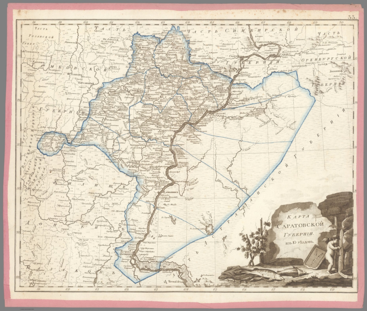
- Author
-
Aleksandr Mikhailovich Wilbrecht [Александр Михайлович Вильбрехт] (1757 - 1823)
- Subjects
- Russia
- Abstract
"Folio Atlas, but here with Complete Contents contemporarily left unbound and presented as 47 separate copper engraved leaves, each with contemporary pink paper edging. Extremely rare and historically important – the finest Enlightenment Era atlas of the Russian Empire, being the second edition of the work, made on the orders of Czar Paul I to present his new jurisdictional reforms, created by Aleksandr Mikhailovich Wilbrecht, the Chief Geographer and Cartographer to the Imperial Court, from the best sources and surveys, a complete example with 43 maps and 2 preliminary leaves, including a giant 3-sheet general map of the Russian Empire with an important inset depicting the Gulf of Alaska and northern British Columbia coasts, dozens of maps of individual Russian ‘gubernia’ (provinces) of unprecedented accuracy, as well as a map focusing upon Alaska and Kamchatka predicated upon intelligence gained from numerous Russian and British exploring expeditions; all maps beautifully decorated with allegorical cartouches, with text in Russian Cyrillic, published in St. Petersburg by the Czar’s Geographical Department; an extraordinary example clearly never bound, but preserved ‘in plano’ with all leaves with original outline hand colour and contemporary pink paper edging. This work is the finest Enlightenment Era atlas of the Russian Empire (which then included Alaska), and one of the foundational monuments of Russian scientific cartography and geographic intelligence. It is the revised second edition of a work first issued in 1792, and was made by Aleksandr Mikhailovich Wilbrecht, an exceedingly talented geographer, cartographer, mathematician and astronomer, who was the chief geographer and mapmaker to the Imperial Court. This revised edition of the atlas was created on the orders of Czar Paul I especially to show the empire’s new internal jurisdictions which were imposed per his reforms. The folio atlas features 43 maps, including a giant 3-sheet general map of the entire Russian Empire featuring an inset bearing a historically significant map depicting Alaska and much of the coast of British Columbia; individual maps of all of Russia’s first-level jurisdictions predicated upon the best surveys and sources; plus, a large format map of Kamchatka, Alaska and the northern BC Coast, predated upon intelligence from ground-breaking exploring expeditions. All maps are beautifully adored with allegorical cartouches that portray Russia to be a powerful, autocratic state, enlightened by science, culture and commerce, and which vanquishes its enemies. The present example of the atlas is complete, featuring 47 engraved leaves (2 preliminaries, and 43 maps on 45 leaves – the maximum called for); however, it was clearly never bound (the sheets are of dissonant sizes), with the borders of each sheet contemporarily edged with pink paper, allowing the maps to be conveniently enjoyed in plano. The first edition of the atlas, Российский атлас, из сорока четырёх карт состоящий и на сорок два наместничества империю разделяющий [Russian Atlas, consisting of Forty- Four Maps and dividing the Empire into Forty-Two Vice-royalties] (1792), was created by Wilbrecht on the orders of Empress Catherine II the Great (r. 1762-96) to show the new internal jurisdictions of the Russian Empire as imposed by her decree, ‘Institutions for the Management of the Provinces’ (November 7, 1775). Changing the nature and boundaries of the first-level jurisdictions in Russa was not simply a bureaucratic matter, but rather it had a profound impact upon land rights, taxation and economic and infrastructure development. Catherine II’s jurisdictional reforms, which were fully implemented in 1785, saw the empire divided into 38 наместничества (namestnichestva / vice-royalties), 3 provinces, 1 region and 1 special autonomous entity (governed by the Don Cossacks). During the 1790s, Catherine ordered further revisions to the Russian jurisdictions, such that upon her death, in 1796, the empire had 48 namestnichestva. The Wilbrecht atlas was only the second official atlas of the Russian Empire, having been preceded only by the Imperial Academy of Sciences’s Атлас Российской, состоящий из девятнадцати специальных карт… [The Russian Atlas, consisting of Nineteen Special Maps…] (St. Petersburg, 1745), which while a triumph in its time, by the 1790s was considered so outdated as to be practically obsolete. Catherine II’s son and successor, Czar Paul I (r. 1796 - 1801), a clinically insane ruler (who was eventually murdered on the orders of his own son!) absolutely despised his mother and went to great efforts to erase or change virtually anything that he attributed to her rule – including her jurisdictional reforms. He dissolved the 51 namestnichestva and converted them into 42 губе́рния (gubernia / provinces), an act which had significant effects upon public affairs across the empire. Paul I’s jurisdictional reforms naturally made the 1792 Wilbrecht atlas in good measure obsolete. The present 1800 edition of the atlas features largely the same maps and topographical content but sees the plates heavily reworked to show the new jurisdictions, with the titles altered accordingly (ex. on the Title Page and on Map no. 1, Catherine II’s cypher had been replaced by that of Paul I). The atlas fully preserves its important depictions of the Alaska and the northern BC coasts. To clear up any confusion, in the period between 1792 and 1800, Wilbrecht seemingly issued many of the atlas’s constituent maps separately, while groupings of maps were consolidated into what seems to have been atlas factice, such that many surviving examples of the atlas, even some held by elite institutions, are today found incomplete. Thus, the present example is notable for being complete with the maximum number of maps called for. * While the present example of the Wilbrecht Atlas is not bound, it features all the contents as called for, including: 1 Title Page, 1 Contents Register, and 43 maps (1 of which is comprised of 3 un-joined sheets). Some Highlights of the Atlas All the maps in the atlas are of very high quality, and the individual maps of the gubernia are the finest and, in many cases, the first accurate maps of these regions. They are predicated upon a composite of sources, in some cases, good scientific surveys, while accompanied by spectacular iconographic adornment. From an international perspective, the most significant elements are the depictions of the Russian Far East, Russian America (Alaska), and the adjacent coastlines of what is today British Columbia, as the true scientific conception of these regions was then emerging due to on-going exploring expeditions conducted by both Russian and British mariners. Map no. 42B., Восточная часть Иркутской губернии с прилежащими островами и западным берегом Америки [The Eastern Part of the Irkutsk Province with Adjacent Islands and the Western Coast of America], showcases a historically important depiction of Alaska and Kamchatka, derived from expeditions ranging from the 1720s to the 1780s. It is derived from Wilbrecht’s separately issued Карта представляющая открытия Российских мореплавателей на Тихом океане и английского капитана Кукка [Map representing the Discoveries of Russian Navigators in the Pacific Ocean and of the English Captain Cook] (1787), although its projection is quite different. For the littoral areas of Alaska, the map shows a sophisticated awareness of the pre-Cook Russian expeditions of Vitus Bering, Aleksei Chirikov, Pyotyr Krenitsyn and Martin Spanberg, etc., while fully embracing the discoveries from Cook’s Third Voyage (1778-9). The map also presents recent revelations due to the likes of Gerasim Ismailov, who discovered the Kenai Peninsula, and Dimitry Bocharov’s exploration of Kodiak Island and the Alaska Peninsula. In the deep interior (in the modern Northwest Territories), the map shows the discoveries of Samuel Hearn. In a similar vein, the inset on Map No. 1 (the general map of the Russian Empire), Карта представляющая частьзападного берега Америки от полуострова Аляски до залива Нутки положеннаго по новейшим открытиям зделанным Российскими и Английскими мореплавателями в 1784, 1786 и 1787 годах [A Map Representing Part of the Western Coast of America from the Alaska Peninsula to Nootka Bay based on the Latest Discoveries made by Russian and English Navigators in the years 1784, 1786 and 1787], shows the Pacific coast of North America, from the base of the Alaska Peninsula, in the northwest, down the just past Nootka Sound, Vancouver Island, in the southeast. The depiction of the Alaska coast is, in some ways, more advanced than that of Map 42B, especially with respect to its portrayal of places like the Kodiak Archipelago and Prince William Sound. The BC Coast shows an awareness of the discoveries of George Dixon and Nathaniel Portlock (1786-7), especially with regards to the Queen Charlotte Islands (Haida Gwaii) and vicinity. The mapping of north-central Siberia showcased by Map No. 41. Карта Тобольской губернии из 16 уездов [Map of the Tobolsk Province of 16 Counties], is quite interesting, capturing such details as the locations of villages, winter encampments, fortresses, monasteries, mines, salt and fishing works, and the routes of the exploration expeditions of Stepan Malygin (1734-5), Aleksei Ivanovich Skuratov (1734-5), Dmitry Ovtsyn (1735), Muraviev & Pavlov (1737) and Fedor Rozmyslov (1768), while also noting the place where Willem Barents’s expedition wintered in 1596. Aleksandr Mikhailovich Wilbrecht: Leading Russian Cartographer of the Enlightnement Aleksandr Mikhailovich Wilbrecht [Александр Михайлович Вильбрехт] (1757 - 1823) was a cartographer, geographer, astronomer and mathematician, who was the most important mapmaker in the Russian Empire during the late 18th and early 19th centuries, and generally a major force in Enlightenment science in the country. Born to an affluent St. Peterburg family, of partial German ancestry, Wilbrecht studied at the Academy of Arts and the School of the Army Noble Corps. After his graduation, he became a map draughtsman at the Geographical Department of the Imperial Academy of Sciences, before working in more senior roles at the Geographical Department of the Cabinet, the Military Topographic Depot, and the Geographical Department of the Ministry of Education. Wilbrecht came to the personal attention of Catherine the Great and, in 1785, was appointed to head the Higher School of Mathematics of the Imperial Mining School, as well as being the Chief Geographer of the Geographical Department of the Cabinet of Her Imperial Majesty. In these capacities, Wilbrecht’s greatest achievement was the present atlas of the Russian Empire (1792, 1800), with other highlights including his important map of the North Pacific, Карта представляющая открытия Российских мореплавателей на Тихом океане и английского капитана Кукка [A Map Representing the Discoveries of Russian Navigators in the Pacific Ocean and the English Captain Cook] (1787); Карта театра войны Российской империи против шведов сочиненная [Map of the Theatre of War of the Russian Empire against the Swedes, Composed] (1789); and the Подробная карта Российской империи и близлежащих заграничных владений [A Detailed Map of the Russian Empire and nearby Foreign Possessions] (1804, revised 1816), nicknamed the “Stolist Map” a colossal 100-sheet map of the European Russia. As the Russia’s leading geographic educator, Wilbrecht published the important works Новый Атлас или собрание карт всех частей земного шара, почерпнутый из разных сочинителей и напечатанный в Санкт-Петербурге для употребления Юношества в 1793 году при Горном училище [The New Atlas or a Collection of Maps of all Parts of the Globe, drawn from Different Writers and Printed in St. Petersburg for the Use of Youth in 1793 at the Mining School] (1793) and Атлас Российской империи изданной для употребления юношества [Atlas of the Russian Empire published for the Use of the Youth] (1794). Late in life, Wilbrecht became the Director of the Military Topographic Depot, whereupon he introduced top-notch scientific cartography to the Russian Army. A Note on Rarity The atlas, in either the 1792 or 1800 editions, and its intermediate variations, is very rare, especially as complete with all maps as called for in the registers. While there are surely several complete examples of the atlas in various Russian institutions, the only complete example of the 1800 edition we could is trace is held by the National Library of Russia (St. Petersburg). Outside of Russia, the only complete examples of the atlas we can locate are two 1792 editions, held by the Royal Geographical Society and the Beinecke Library (Yale University), although it is possible that there could be a couple more examples that are not properly catalogued online. Incomplete examples of the 1792 edition are held by the Harvard University Library, British Library and the National Library of Scotland, while an incomplete example of the 1800 edition is held by the University of California-Berkeley. The only complete example of the atlas we can trace as having been on the market since 1969 is for an example of the 1792 edition, sold in 2006 at Bonhams’s New York. A substantially incomplete example of the 1792 edition, with only 30 maps, was sold at Sotheby’s London in 2019. (Alexander Johnson/Dasa Pahor, 2023), National Library of Russia (St. Petersburg): К 1-Росс 8/14; cf. [1792 ed.:] 1792: Royal Geographical Society: mr 1.C.112, Beinecke Library (Yale University): 1976 Folio 105; Leo BAGROW, ed. Henry W. Castner, A History of Russian Cartography up to 1800 (Wolfe Island, Ontario: Walker Press, 1975), Part V, pp. 212, 215.
- Published
- 1800
42. 30. Карта Пермской губернии из 10 уездов. [Map of the Perm Province of 10 Counties].
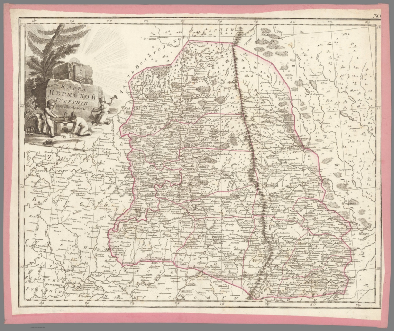
- Author
-
Aleksandr Mikhailovich Wilbrecht [Александр Михайлович Вильбрехт] (1757 - 1823)
- Subjects
- Perm (Russia), Russia
- Abstract
"Folio Atlas, but here with Complete Contents contemporarily left unbound and presented as 47 separate copper engraved leaves, each with contemporary pink paper edging. Extremely rare and historically important – the finest Enlightenment Era atlas of the Russian Empire, being the second edition of the work, made on the orders of Czar Paul I to present his new jurisdictional reforms, created by Aleksandr Mikhailovich Wilbrecht, the Chief Geographer and Cartographer to the Imperial Court, from the best sources and surveys, a complete example with 43 maps and 2 preliminary leaves, including a giant 3-sheet general map of the Russian Empire with an important inset depicting the Gulf of Alaska and northern British Columbia coasts, dozens of maps of individual Russian ‘gubernia’ (provinces) of unprecedented accuracy, as well as a map focusing upon Alaska and Kamchatka predicated upon intelligence gained from numerous Russian and British exploring expeditions; all maps beautifully decorated with allegorical cartouches, with text in Russian Cyrillic, published in St. Petersburg by the Czar’s Geographical Department; an extraordinary example clearly never bound, but preserved ‘in plano’ with all leaves with original outline hand colour and contemporary pink paper edging. This work is the finest Enlightenment Era atlas of the Russian Empire (which then included Alaska), and one of the foundational monuments of Russian scientific cartography and geographic intelligence. It is the revised second edition of a work first issued in 1792, and was made by Aleksandr Mikhailovich Wilbrecht, an exceedingly talented geographer, cartographer, mathematician and astronomer, who was the chief geographer and mapmaker to the Imperial Court. This revised edition of the atlas was created on the orders of Czar Paul I especially to show the empire’s new internal jurisdictions which were imposed per his reforms. The folio atlas features 43 maps, including a giant 3-sheet general map of the entire Russian Empire featuring an inset bearing a historically significant map depicting Alaska and much of the coast of British Columbia; individual maps of all of Russia’s first-level jurisdictions predicated upon the best surveys and sources; plus, a large format map of Kamchatka, Alaska and the northern BC Coast, predated upon intelligence from ground-breaking exploring expeditions. All maps are beautifully adored with allegorical cartouches that portray Russia to be a powerful, autocratic state, enlightened by science, culture and commerce, and which vanquishes its enemies. The present example of the atlas is complete, featuring 47 engraved leaves (2 preliminaries, and 43 maps on 45 leaves – the maximum called for); however, it was clearly never bound (the sheets are of dissonant sizes), with the borders of each sheet contemporarily edged with pink paper, allowing the maps to be conveniently enjoyed in plano. The first edition of the atlas, Российский атлас, из сорока четырёх карт состоящий и на сорок два наместничества империю разделяющий [Russian Atlas, consisting of Forty- Four Maps and dividing the Empire into Forty-Two Vice-royalties] (1792), was created by Wilbrecht on the orders of Empress Catherine II the Great (r. 1762-96) to show the new internal jurisdictions of the Russian Empire as imposed by her decree, ‘Institutions for the Management of the Provinces’ (November 7, 1775). Changing the nature and boundaries of the first-level jurisdictions in Russa was not simply a bureaucratic matter, but rather it had a profound impact upon land rights, taxation and economic and infrastructure development. Catherine II’s jurisdictional reforms, which were fully implemented in 1785, saw the empire divided into 38 наместничества (namestnichestva / vice-royalties), 3 provinces, 1 region and 1 special autonomous entity (governed by the Don Cossacks). During the 1790s, Catherine ordered further revisions to the Russian jurisdictions, such that upon her death, in 1796, the empire had 48 namestnichestva. The Wilbrecht atlas was only the second official atlas of the Russian Empire, having been preceded only by the Imperial Academy of Sciences’s Атлас Российской, состоящий из девятнадцати специальных карт… [The Russian Atlas, consisting of Nineteen Special Maps…] (St. Petersburg, 1745), which while a triumph in its time, by the 1790s was considered so outdated as to be practically obsolete. Catherine II’s son and successor, Czar Paul I (r. 1796 - 1801), a clinically insane ruler (who was eventually murdered on the orders of his own son!) absolutely despised his mother and went to great efforts to erase or change virtually anything that he attributed to her rule – including her jurisdictional reforms. He dissolved the 51 namestnichestva and converted them into 42 губе́рния (gubernia / provinces), an act which had significant effects upon public affairs across the empire. Paul I’s jurisdictional reforms naturally made the 1792 Wilbrecht atlas in good measure obsolete. The present 1800 edition of the atlas features largely the same maps and topographical content but sees the plates heavily reworked to show the new jurisdictions, with the titles altered accordingly (ex. on the Title Page and on Map no. 1, Catherine II’s cypher had been replaced by that of Paul I). The atlas fully preserves its important depictions of the Alaska and the northern BC coasts. To clear up any confusion, in the period between 1792 and 1800, Wilbrecht seemingly issued many of the atlas’s constituent maps separately, while groupings of maps were consolidated into what seems to have been atlas factice, such that many surviving examples of the atlas, even some held by elite institutions, are today found incomplete. Thus, the present example is notable for being complete with the maximum number of maps called for. * While the present example of the Wilbrecht Atlas is not bound, it features all the contents as called for, including: 1 Title Page, 1 Contents Register, and 43 maps (1 of which is comprised of 3 un-joined sheets). Some Highlights of the Atlas All the maps in the atlas are of very high quality, and the individual maps of the gubernia are the finest and, in many cases, the first accurate maps of these regions. They are predicated upon a composite of sources, in some cases, good scientific surveys, while accompanied by spectacular iconographic adornment. From an international perspective, the most significant elements are the depictions of the Russian Far East, Russian America (Alaska), and the adjacent coastlines of what is today British Columbia, as the true scientific conception of these regions was then emerging due to on-going exploring expeditions conducted by both Russian and British mariners. Map no. 42B., Восточная часть Иркутской губернии с прилежащими островами и западным берегом Америки [The Eastern Part of the Irkutsk Province with Adjacent Islands and the Western Coast of America], showcases a historically important depiction of Alaska and Kamchatka, derived from expeditions ranging from the 1720s to the 1780s. It is derived from Wilbrecht’s separately issued Карта представляющая открытия Российских мореплавателей на Тихом океане и английского капитана Кукка [Map representing the Discoveries of Russian Navigators in the Pacific Ocean and of the English Captain Cook] (1787), although its projection is quite different. For the littoral areas of Alaska, the map shows a sophisticated awareness of the pre-Cook Russian expeditions of Vitus Bering, Aleksei Chirikov, Pyotyr Krenitsyn and Martin Spanberg, etc., while fully embracing the discoveries from Cook’s Third Voyage (1778-9). The map also presents recent revelations due to the likes of Gerasim Ismailov, who discovered the Kenai Peninsula, and Dimitry Bocharov’s exploration of Kodiak Island and the Alaska Peninsula. In the deep interior (in the modern Northwest Territories), the map shows the discoveries of Samuel Hearn. In a similar vein, the inset on Map No. 1 (the general map of the Russian Empire), Карта представляющая частьзападного берега Америки от полуострова Аляски до залива Нутки положеннаго по новейшим открытиям зделанным Российскими и Английскими мореплавателями в 1784, 1786 и 1787 годах [A Map Representing Part of the Western Coast of America from the Alaska Peninsula to Nootka Bay based on the Latest Discoveries made by Russian and English Navigators in the years 1784, 1786 and 1787], shows the Pacific coast of North America, from the base of the Alaska Peninsula, in the northwest, down the just past Nootka Sound, Vancouver Island, in the southeast. The depiction of the Alaska coast is, in some ways, more advanced than that of Map 42B, especially with respect to its portrayal of places like the Kodiak Archipelago and Prince William Sound. The BC Coast shows an awareness of the discoveries of George Dixon and Nathaniel Portlock (1786-7), especially with regards to the Queen Charlotte Islands (Haida Gwaii) and vicinity. The mapping of north-central Siberia showcased by Map No. 41. Карта Тобольской губернии из 16 уездов [Map of the Tobolsk Province of 16 Counties], is quite interesting, capturing such details as the locations of villages, winter encampments, fortresses, monasteries, mines, salt and fishing works, and the routes of the exploration expeditions of Stepan Malygin (1734-5), Aleksei Ivanovich Skuratov (1734-5), Dmitry Ovtsyn (1735), Muraviev & Pavlov (1737) and Fedor Rozmyslov (1768), while also noting the place where Willem Barents’s expedition wintered in 1596. Aleksandr Mikhailovich Wilbrecht: Leading Russian Cartographer of the Enlightnement Aleksandr Mikhailovich Wilbrecht [Александр Михайлович Вильбрехт] (1757 - 1823) was a cartographer, geographer, astronomer and mathematician, who was the most important mapmaker in the Russian Empire during the late 18th and early 19th centuries, and generally a major force in Enlightenment science in the country. Born to an affluent St. Peterburg family, of partial German ancestry, Wilbrecht studied at the Academy of Arts and the School of the Army Noble Corps. After his graduation, he became a map draughtsman at the Geographical Department of the Imperial Academy of Sciences, before working in more senior roles at the Geographical Department of the Cabinet, the Military Topographic Depot, and the Geographical Department of the Ministry of Education. Wilbrecht came to the personal attention of Catherine the Great and, in 1785, was appointed to head the Higher School of Mathematics of the Imperial Mining School, as well as being the Chief Geographer of the Geographical Department of the Cabinet of Her Imperial Majesty. In these capacities, Wilbrecht’s greatest achievement was the present atlas of the Russian Empire (1792, 1800), with other highlights including his important map of the North Pacific, Карта представляющая открытия Российских мореплавателей на Тихом океане и английского капитана Кукка [A Map Representing the Discoveries of Russian Navigators in the Pacific Ocean and the English Captain Cook] (1787); Карта театра войны Российской империи против шведов сочиненная [Map of the Theatre of War of the Russian Empire against the Swedes, Composed] (1789); and the Подробная карта Российской империи и близлежащих заграничных владений [A Detailed Map of the Russian Empire and nearby Foreign Possessions] (1804, revised 1816), nicknamed the “Stolist Map” a colossal 100-sheet map of the European Russia. As the Russia’s leading geographic educator, Wilbrecht published the important works Новый Атлас или собрание карт всех частей земного шара, почерпнутый из разных сочинителей и напечатанный в Санкт-Петербурге для употребления Юношества в 1793 году при Горном училище [The New Atlas or a Collection of Maps of all Parts of the Globe, drawn from Different Writers and Printed in St. Petersburg for the Use of Youth in 1793 at the Mining School] (1793) and Атлас Российской империи изданной для употребления юношества [Atlas of the Russian Empire published for the Use of the Youth] (1794). Late in life, Wilbrecht became the Director of the Military Topographic Depot, whereupon he introduced top-notch scientific cartography to the Russian Army. A Note on Rarity The atlas, in either the 1792 or 1800 editions, and its intermediate variations, is very rare, especially as complete with all maps as called for in the registers. While there are surely several complete examples of the atlas in various Russian institutions, the only complete example of the 1800 edition we could is trace is held by the National Library of Russia (St. Petersburg). Outside of Russia, the only complete examples of the atlas we can locate are two 1792 editions, held by the Royal Geographical Society and the Beinecke Library (Yale University), although it is possible that there could be a couple more examples that are not properly catalogued online. Incomplete examples of the 1792 edition are held by the Harvard University Library, British Library and the National Library of Scotland, while an incomplete example of the 1800 edition is held by the University of California-Berkeley. The only complete example of the atlas we can trace as having been on the market since 1969 is for an example of the 1792 edition, sold in 2006 at Bonhams’s New York. A substantially incomplete example of the 1792 edition, with only 30 maps, was sold at Sotheby’s London in 2019. (Alexander Johnson/Dasa Pahor, 2023), National Library of Russia (St. Petersburg): К 1-Росс 8/14; cf. [1792 ed.:] 1792: Royal Geographical Society: mr 1.C.112, Beinecke Library (Yale University): 1976 Folio 105; Leo BAGROW, ed. Henry W. Castner, A History of Russian Cartography up to 1800 (Wolfe Island, Ontario: Walker Press, 1975), Part V, pp. 212, 215.
- Published
- 1800
43. 31. Карта Оренбургской губернии из 10 уездов. [Map of the Orenburg Province of 10 Districts].
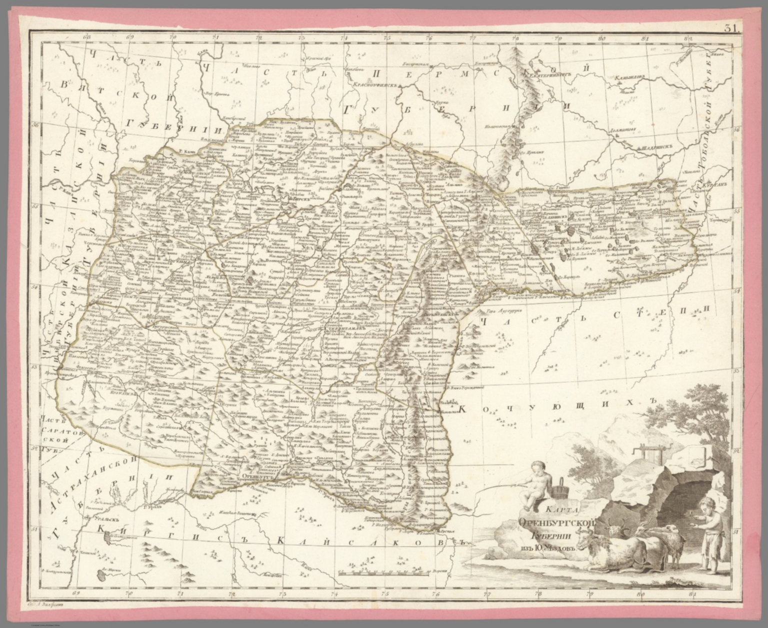
- Author
-
Aleksandr Mikhailovich Wilbrecht [Александр Михайлович Вильбрехт] (1757 - 1823)
- Subjects
- Russia
- Abstract
"Folio Atlas, but here with Complete Contents contemporarily left unbound and presented as 47 separate copper engraved leaves, each with contemporary pink paper edging. Extremely rare and historically important – the finest Enlightenment Era atlas of the Russian Empire, being the second edition of the work, made on the orders of Czar Paul I to present his new jurisdictional reforms, created by Aleksandr Mikhailovich Wilbrecht, the Chief Geographer and Cartographer to the Imperial Court, from the best sources and surveys, a complete example with 43 maps and 2 preliminary leaves, including a giant 3-sheet general map of the Russian Empire with an important inset depicting the Gulf of Alaska and northern British Columbia coasts, dozens of maps of individual Russian ‘gubernia’ (provinces) of unprecedented accuracy, as well as a map focusing upon Alaska and Kamchatka predicated upon intelligence gained from numerous Russian and British exploring expeditions; all maps beautifully decorated with allegorical cartouches, with text in Russian Cyrillic, published in St. Petersburg by the Czar’s Geographical Department; an extraordinary example clearly never bound, but preserved ‘in plano’ with all leaves with original outline hand colour and contemporary pink paper edging. This work is the finest Enlightenment Era atlas of the Russian Empire (which then included Alaska), and one of the foundational monuments of Russian scientific cartography and geographic intelligence. It is the revised second edition of a work first issued in 1792, and was made by Aleksandr Mikhailovich Wilbrecht, an exceedingly talented geographer, cartographer, mathematician and astronomer, who was the chief geographer and mapmaker to the Imperial Court. This revised edition of the atlas was created on the orders of Czar Paul I especially to show the empire’s new internal jurisdictions which were imposed per his reforms. The folio atlas features 43 maps, including a giant 3-sheet general map of the entire Russian Empire featuring an inset bearing a historically significant map depicting Alaska and much of the coast of British Columbia; individual maps of all of Russia’s first-level jurisdictions predicated upon the best surveys and sources; plus, a large format map of Kamchatka, Alaska and the northern BC Coast, predated upon intelligence from ground-breaking exploring expeditions. All maps are beautifully adored with allegorical cartouches that portray Russia to be a powerful, autocratic state, enlightened by science, culture and commerce, and which vanquishes its enemies. The present example of the atlas is complete, featuring 47 engraved leaves (2 preliminaries, and 43 maps on 45 leaves – the maximum called for); however, it was clearly never bound (the sheets are of dissonant sizes), with the borders of each sheet contemporarily edged with pink paper, allowing the maps to be conveniently enjoyed in plano. The first edition of the atlas, Российский атлас, из сорока четырёх карт состоящий и на сорок два наместничества империю разделяющий [Russian Atlas, consisting of Forty- Four Maps and dividing the Empire into Forty-Two Vice-royalties] (1792), was created by Wilbrecht on the orders of Empress Catherine II the Great (r. 1762-96) to show the new internal jurisdictions of the Russian Empire as imposed by her decree, ‘Institutions for the Management of the Provinces’ (November 7, 1775). Changing the nature and boundaries of the first-level jurisdictions in Russa was not simply a bureaucratic matter, but rather it had a profound impact upon land rights, taxation and economic and infrastructure development. Catherine II’s jurisdictional reforms, which were fully implemented in 1785, saw the empire divided into 38 наместничества (namestnichestva / vice-royalties), 3 provinces, 1 region and 1 special autonomous entity (governed by the Don Cossacks). During the 1790s, Catherine ordered further revisions to the Russian jurisdictions, such that upon her death, in 1796, the empire had 48 namestnichestva. The Wilbrecht atlas was only the second official atlas of the Russian Empire, having been preceded only by the Imperial Academy of Sciences’s Атлас Российской, состоящий из девятнадцати специальных карт… [The Russian Atlas, consisting of Nineteen Special Maps…] (St. Petersburg, 1745), which while a triumph in its time, by the 1790s was considered so outdated as to be practically obsolete. Catherine II’s son and successor, Czar Paul I (r. 1796 - 1801), a clinically insane ruler (who was eventually murdered on the orders of his own son!) absolutely despised his mother and went to great efforts to erase or change virtually anything that he attributed to her rule – including her jurisdictional reforms. He dissolved the 51 namestnichestva and converted them into 42 губе́рния (gubernia / provinces), an act which had significant effects upon public affairs across the empire. Paul I’s jurisdictional reforms naturally made the 1792 Wilbrecht atlas in good measure obsolete. The present 1800 edition of the atlas features largely the same maps and topographical content but sees the plates heavily reworked to show the new jurisdictions, with the titles altered accordingly (ex. on the Title Page and on Map no. 1, Catherine II’s cypher had been replaced by that of Paul I). The atlas fully preserves its important depictions of the Alaska and the northern BC coasts. To clear up any confusion, in the period between 1792 and 1800, Wilbrecht seemingly issued many of the atlas’s constituent maps separately, while groupings of maps were consolidated into what seems to have been atlas factice, such that many surviving examples of the atlas, even some held by elite institutions, are today found incomplete. Thus, the present example is notable for being complete with the maximum number of maps called for. * While the present example of the Wilbrecht Atlas is not bound, it features all the contents as called for, including: 1 Title Page, 1 Contents Register, and 43 maps (1 of which is comprised of 3 un-joined sheets). Some Highlights of the Atlas All the maps in the atlas are of very high quality, and the individual maps of the gubernia are the finest and, in many cases, the first accurate maps of these regions. They are predicated upon a composite of sources, in some cases, good scientific surveys, while accompanied by spectacular iconographic adornment. From an international perspective, the most significant elements are the depictions of the Russian Far East, Russian America (Alaska), and the adjacent coastlines of what is today British Columbia, as the true scientific conception of these regions was then emerging due to on-going exploring expeditions conducted by both Russian and British mariners. Map no. 42B., Восточная часть Иркутской губернии с прилежащими островами и западным берегом Америки [The Eastern Part of the Irkutsk Province with Adjacent Islands and the Western Coast of America], showcases a historically important depiction of Alaska and Kamchatka, derived from expeditions ranging from the 1720s to the 1780s. It is derived from Wilbrecht’s separately issued Карта представляющая открытия Российских мореплавателей на Тихом океане и английского капитана Кукка [Map representing the Discoveries of Russian Navigators in the Pacific Ocean and of the English Captain Cook] (1787), although its projection is quite different. For the littoral areas of Alaska, the map shows a sophisticated awareness of the pre-Cook Russian expeditions of Vitus Bering, Aleksei Chirikov, Pyotyr Krenitsyn and Martin Spanberg, etc., while fully embracing the discoveries from Cook’s Third Voyage (1778-9). The map also presents recent revelations due to the likes of Gerasim Ismailov, who discovered the Kenai Peninsula, and Dimitry Bocharov’s exploration of Kodiak Island and the Alaska Peninsula. In the deep interior (in the modern Northwest Territories), the map shows the discoveries of Samuel Hearn. In a similar vein, the inset on Map No. 1 (the general map of the Russian Empire), Карта представляющая частьзападного берега Америки от полуострова Аляски до залива Нутки положеннаго по новейшим открытиям зделанным Российскими и Английскими мореплавателями в 1784, 1786 и 1787 годах [A Map Representing Part of the Western Coast of America from the Alaska Peninsula to Nootka Bay based on the Latest Discoveries made by Russian and English Navigators in the years 1784, 1786 and 1787], shows the Pacific coast of North America, from the base of the Alaska Peninsula, in the northwest, down the just past Nootka Sound, Vancouver Island, in the southeast. The depiction of the Alaska coast is, in some ways, more advanced than that of Map 42B, especially with respect to its portrayal of places like the Kodiak Archipelago and Prince William Sound. The BC Coast shows an awareness of the discoveries of George Dixon and Nathaniel Portlock (1786-7), especially with regards to the Queen Charlotte Islands (Haida Gwaii) and vicinity. The mapping of north-central Siberia showcased by Map No. 41. Карта Тобольской губернии из 16 уездов [Map of the Tobolsk Province of 16 Counties], is quite interesting, capturing such details as the locations of villages, winter encampments, fortresses, monasteries, mines, salt and fishing works, and the routes of the exploration expeditions of Stepan Malygin (1734-5), Aleksei Ivanovich Skuratov (1734-5), Dmitry Ovtsyn (1735), Muraviev & Pavlov (1737) and Fedor Rozmyslov (1768), while also noting the place where Willem Barents’s expedition wintered in 1596. Aleksandr Mikhailovich Wilbrecht: Leading Russian Cartographer of the Enlightnement Aleksandr Mikhailovich Wilbrecht [Александр Михайлович Вильбрехт] (1757 - 1823) was a cartographer, geographer, astronomer and mathematician, who was the most important mapmaker in the Russian Empire during the late 18th and early 19th centuries, and generally a major force in Enlightenment science in the country. Born to an affluent St. Peterburg family, of partial German ancestry, Wilbrecht studied at the Academy of Arts and the School of the Army Noble Corps. After his graduation, he became a map draughtsman at the Geographical Department of the Imperial Academy of Sciences, before working in more senior roles at the Geographical Department of the Cabinet, the Military Topographic Depot, and the Geographical Department of the Ministry of Education. Wilbrecht came to the personal attention of Catherine the Great and, in 1785, was appointed to head the Higher School of Mathematics of the Imperial Mining School, as well as being the Chief Geographer of the Geographical Department of the Cabinet of Her Imperial Majesty. In these capacities, Wilbrecht’s greatest achievement was the present atlas of the Russian Empire (1792, 1800), with other highlights including his important map of the North Pacific, Карта представляющая открытия Российских мореплавателей на Тихом океане и английского капитана Кукка [A Map Representing the Discoveries of Russian Navigators in the Pacific Ocean and the English Captain Cook] (1787); Карта театра войны Российской империи против шведов сочиненная [Map of the Theatre of War of the Russian Empire against the Swedes, Composed] (1789); and the Подробная карта Российской империи и близлежащих заграничных владений [A Detailed Map of the Russian Empire and nearby Foreign Possessions] (1804, revised 1816), nicknamed the “Stolist Map” a colossal 100-sheet map of the European Russia. As the Russia’s leading geographic educator, Wilbrecht published the important works Новый Атлас или собрание карт всех частей земного шара, почерпнутый из разных сочинителей и напечатанный в Санкт-Петербурге для употребления Юношества в 1793 году при Горном училище [The New Atlas or a Collection of Maps of all Parts of the Globe, drawn from Different Writers and Printed in St. Petersburg for the Use of Youth in 1793 at the Mining School] (1793) and Атлас Российской империи изданной для употребления юношества [Atlas of the Russian Empire published for the Use of the Youth] (1794). Late in life, Wilbrecht became the Director of the Military Topographic Depot, whereupon he introduced top-notch scientific cartography to the Russian Army. A Note on Rarity The atlas, in either the 1792 or 1800 editions, and its intermediate variations, is very rare, especially as complete with all maps as called for in the registers. While there are surely several complete examples of the atlas in various Russian institutions, the only complete example of the 1800 edition we could is trace is held by the National Library of Russia (St. Petersburg). Outside of Russia, the only complete examples of the atlas we can locate are two 1792 editions, held by the Royal Geographical Society and the Beinecke Library (Yale University), although it is possible that there could be a couple more examples that are not properly catalogued online. Incomplete examples of the 1792 edition are held by the Harvard University Library, British Library and the National Library of Scotland, while an incomplete example of the 1800 edition is held by the University of California-Berkeley. The only complete example of the atlas we can trace as having been on the market since 1969 is for an example of the 1792 edition, sold in 2006 at Bonhams’s New York. A substantially incomplete example of the 1792 edition, with only 30 maps, was sold at Sotheby’s London in 2019. (Alexander Johnson/Dasa Pahor, 2023), National Library of Russia (St. Petersburg): К 1-Росс 8/14; cf. [1792 ed.:] 1792: Royal Geographical Society: mr 1.C.112, Beinecke Library (Yale University): 1976 Folio 105; Leo BAGROW, ed. Henry W. Castner, A History of Russian Cartography up to 1800 (Wolfe Island, Ontario: Walker Press, 1975), Part V, pp. 212, 215.
- Published
- 1800
44. 28. Карта Казанской губернии из 10 уездов. [Map of the Kazan Province of 10 Districts].
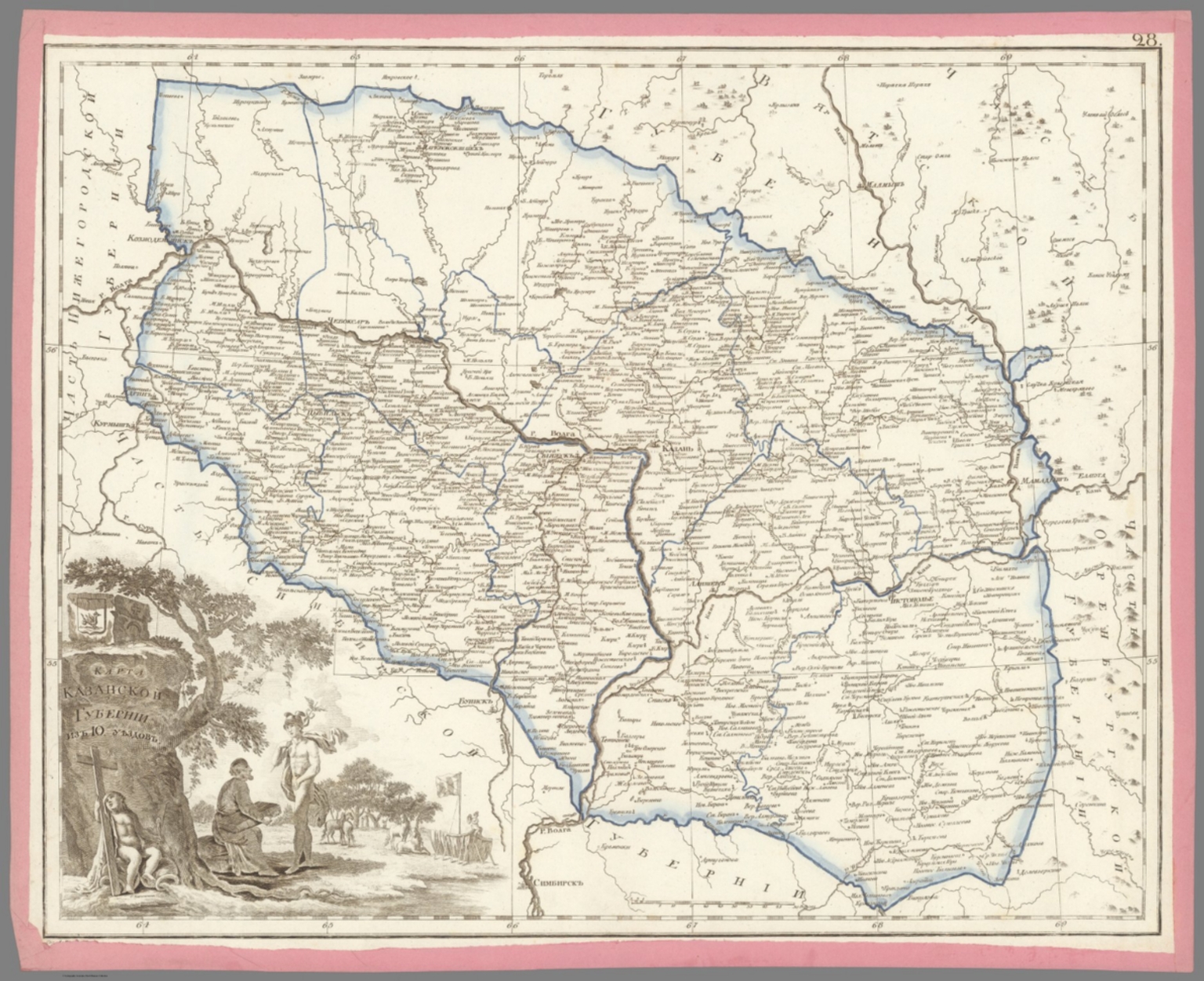
- Author
-
Aleksandr Mikhailovich Wilbrecht [Александр Михайлович Вильбрехт] (1757 - 1823)
- Subjects
- Russia
- Abstract
"Folio Atlas, but here with Complete Contents contemporarily left unbound and presented as 47 separate copper engraved leaves, each with contemporary pink paper edging. Extremely rare and historically important – the finest Enlightenment Era atlas of the Russian Empire, being the second edition of the work, made on the orders of Czar Paul I to present his new jurisdictional reforms, created by Aleksandr Mikhailovich Wilbrecht, the Chief Geographer and Cartographer to the Imperial Court, from the best sources and surveys, a complete example with 43 maps and 2 preliminary leaves, including a giant 3-sheet general map of the Russian Empire with an important inset depicting the Gulf of Alaska and northern British Columbia coasts, dozens of maps of individual Russian ‘gubernia’ (provinces) of unprecedented accuracy, as well as a map focusing upon Alaska and Kamchatka predicated upon intelligence gained from numerous Russian and British exploring expeditions; all maps beautifully decorated with allegorical cartouches, with text in Russian Cyrillic, published in St. Petersburg by the Czar’s Geographical Department; an extraordinary example clearly never bound, but preserved ‘in plano’ with all leaves with original outline hand colour and contemporary pink paper edging. This work is the finest Enlightenment Era atlas of the Russian Empire (which then included Alaska), and one of the foundational monuments of Russian scientific cartography and geographic intelligence. It is the revised second edition of a work first issued in 1792, and was made by Aleksandr Mikhailovich Wilbrecht, an exceedingly talented geographer, cartographer, mathematician and astronomer, who was the chief geographer and mapmaker to the Imperial Court. This revised edition of the atlas was created on the orders of Czar Paul I especially to show the empire’s new internal jurisdictions which were imposed per his reforms. The folio atlas features 43 maps, including a giant 3-sheet general map of the entire Russian Empire featuring an inset bearing a historically significant map depicting Alaska and much of the coast of British Columbia; individual maps of all of Russia’s first-level jurisdictions predicated upon the best surveys and sources; plus, a large format map of Kamchatka, Alaska and the northern BC Coast, predated upon intelligence from ground-breaking exploring expeditions. All maps are beautifully adored with allegorical cartouches that portray Russia to be a powerful, autocratic state, enlightened by science, culture and commerce, and which vanquishes its enemies. The present example of the atlas is complete, featuring 47 engraved leaves (2 preliminaries, and 43 maps on 45 leaves – the maximum called for); however, it was clearly never bound (the sheets are of dissonant sizes), with the borders of each sheet contemporarily edged with pink paper, allowing the maps to be conveniently enjoyed in plano. The first edition of the atlas, Российский атлас, из сорока четырёх карт состоящий и на сорок два наместничества империю разделяющий [Russian Atlas, consisting of Forty- Four Maps and dividing the Empire into Forty-Two Vice-royalties] (1792), was created by Wilbrecht on the orders of Empress Catherine II the Great (r. 1762-96) to show the new internal jurisdictions of the Russian Empire as imposed by her decree, ‘Institutions for the Management of the Provinces’ (November 7, 1775). Changing the nature and boundaries of the first-level jurisdictions in Russa was not simply a bureaucratic matter, but rather it had a profound impact upon land rights, taxation and economic and infrastructure development. Catherine II’s jurisdictional reforms, which were fully implemented in 1785, saw the empire divided into 38 наместничества (namestnichestva / vice-royalties), 3 provinces, 1 region and 1 special autonomous entity (governed by the Don Cossacks). During the 1790s, Catherine ordered further revisions to the Russian jurisdictions, such that upon her death, in 1796, the empire had 48 namestnichestva. The Wilbrecht atlas was only the second official atlas of the Russian Empire, having been preceded only by the Imperial Academy of Sciences’s Атлас Российской, состоящий из девятнадцати специальных карт… [The Russian Atlas, consisting of Nineteen Special Maps…] (St. Petersburg, 1745), which while a triumph in its time, by the 1790s was considered so outdated as to be practically obsolete. Catherine II’s son and successor, Czar Paul I (r. 1796 - 1801), a clinically insane ruler (who was eventually murdered on the orders of his own son!) absolutely despised his mother and went to great efforts to erase or change virtually anything that he attributed to her rule – including her jurisdictional reforms. He dissolved the 51 namestnichestva and converted them into 42 губе́рния (gubernia / provinces), an act which had significant effects upon public affairs across the empire. Paul I’s jurisdictional reforms naturally made the 1792 Wilbrecht atlas in good measure obsolete. The present 1800 edition of the atlas features largely the same maps and topographical content but sees the plates heavily reworked to show the new jurisdictions, with the titles altered accordingly (ex. on the Title Page and on Map no. 1, Catherine II’s cypher had been replaced by that of Paul I). The atlas fully preserves its important depictions of the Alaska and the northern BC coasts. To clear up any confusion, in the period between 1792 and 1800, Wilbrecht seemingly issued many of the atlas’s constituent maps separately, while groupings of maps were consolidated into what seems to have been atlas factice, such that many surviving examples of the atlas, even some held by elite institutions, are today found incomplete. Thus, the present example is notable for being complete with the maximum number of maps called for. * While the present example of the Wilbrecht Atlas is not bound, it features all the contents as called for, including: 1 Title Page, 1 Contents Register, and 43 maps (1 of which is comprised of 3 un-joined sheets). Some Highlights of the Atlas All the maps in the atlas are of very high quality, and the individual maps of the gubernia are the finest and, in many cases, the first accurate maps of these regions. They are predicated upon a composite of sources, in some cases, good scientific surveys, while accompanied by spectacular iconographic adornment. From an international perspective, the most significant elements are the depictions of the Russian Far East, Russian America (Alaska), and the adjacent coastlines of what is today British Columbia, as the true scientific conception of these regions was then emerging due to on-going exploring expeditions conducted by both Russian and British mariners. Map no. 42B., Восточная часть Иркутской губернии с прилежащими островами и западным берегом Америки [The Eastern Part of the Irkutsk Province with Adjacent Islands and the Western Coast of America], showcases a historically important depiction of Alaska and Kamchatka, derived from expeditions ranging from the 1720s to the 1780s. It is derived from Wilbrecht’s separately issued Карта представляющая открытия Российских мореплавателей на Тихом океане и английского капитана Кукка [Map representing the Discoveries of Russian Navigators in the Pacific Ocean and of the English Captain Cook] (1787), although its projection is quite different. For the littoral areas of Alaska, the map shows a sophisticated awareness of the pre-Cook Russian expeditions of Vitus Bering, Aleksei Chirikov, Pyotyr Krenitsyn and Martin Spanberg, etc., while fully embracing the discoveries from Cook’s Third Voyage (1778-9). The map also presents recent revelations due to the likes of Gerasim Ismailov, who discovered the Kenai Peninsula, and Dimitry Bocharov’s exploration of Kodiak Island and the Alaska Peninsula. In the deep interior (in the modern Northwest Territories), the map shows the discoveries of Samuel Hearn. In a similar vein, the inset on Map No. 1 (the general map of the Russian Empire), Карта представляющая частьзападного берега Америки от полуострова Аляски до залива Нутки положеннаго по новейшим открытиям зделанным Российскими и Английскими мореплавателями в 1784, 1786 и 1787 годах [A Map Representing Part of the Western Coast of America from the Alaska Peninsula to Nootka Bay based on the Latest Discoveries made by Russian and English Navigators in the years 1784, 1786 and 1787], shows the Pacific coast of North America, from the base of the Alaska Peninsula, in the northwest, down the just past Nootka Sound, Vancouver Island, in the southeast. The depiction of the Alaska coast is, in some ways, more advanced than that of Map 42B, especially with respect to its portrayal of places like the Kodiak Archipelago and Prince William Sound. The BC Coast shows an awareness of the discoveries of George Dixon and Nathaniel Portlock (1786-7), especially with regards to the Queen Charlotte Islands (Haida Gwaii) and vicinity. The mapping of north-central Siberia showcased by Map No. 41. Карта Тобольской губернии из 16 уездов [Map of the Tobolsk Province of 16 Counties], is quite interesting, capturing such details as the locations of villages, winter encampments, fortresses, monasteries, mines, salt and fishing works, and the routes of the exploration expeditions of Stepan Malygin (1734-5), Aleksei Ivanovich Skuratov (1734-5), Dmitry Ovtsyn (1735), Muraviev & Pavlov (1737) and Fedor Rozmyslov (1768), while also noting the place where Willem Barents’s expedition wintered in 1596. Aleksandr Mikhailovich Wilbrecht: Leading Russian Cartographer of the Enlightnement Aleksandr Mikhailovich Wilbrecht [Александр Михайлович Вильбрехт] (1757 - 1823) was a cartographer, geographer, astronomer and mathematician, who was the most important mapmaker in the Russian Empire during the late 18th and early 19th centuries, and generally a major force in Enlightenment science in the country. Born to an affluent St. Peterburg family, of partial German ancestry, Wilbrecht studied at the Academy of Arts and the School of the Army Noble Corps. After his graduation, he became a map draughtsman at the Geographical Department of the Imperial Academy of Sciences, before working in more senior roles at the Geographical Department of the Cabinet, the Military Topographic Depot, and the Geographical Department of the Ministry of Education. Wilbrecht came to the personal attention of Catherine the Great and, in 1785, was appointed to head the Higher School of Mathematics of the Imperial Mining School, as well as being the Chief Geographer of the Geographical Department of the Cabinet of Her Imperial Majesty. In these capacities, Wilbrecht’s greatest achievement was the present atlas of the Russian Empire (1792, 1800), with other highlights including his important map of the North Pacific, Карта представляющая открытия Российских мореплавателей на Тихом океане и английского капитана Кукка [A Map Representing the Discoveries of Russian Navigators in the Pacific Ocean and the English Captain Cook] (1787); Карта театра войны Российской империи против шведов сочиненная [Map of the Theatre of War of the Russian Empire against the Swedes, Composed] (1789); and the Подробная карта Российской империи и близлежащих заграничных владений [A Detailed Map of the Russian Empire and nearby Foreign Possessions] (1804, revised 1816), nicknamed the “Stolist Map” a colossal 100-sheet map of the European Russia. As the Russia’s leading geographic educator, Wilbrecht published the important works Новый Атлас или собрание карт всех частей земного шара, почерпнутый из разных сочинителей и напечатанный в Санкт-Петербурге для употребления Юношества в 1793 году при Горном училище [The New Atlas or a Collection of Maps of all Parts of the Globe, drawn from Different Writers and Printed in St. Petersburg for the Use of Youth in 1793 at the Mining School] (1793) and Атлас Российской империи изданной для употребления юношества [Atlas of the Russian Empire published for the Use of the Youth] (1794). Late in life, Wilbrecht became the Director of the Military Topographic Depot, whereupon he introduced top-notch scientific cartography to the Russian Army. A Note on Rarity The atlas, in either the 1792 or 1800 editions, and its intermediate variations, is very rare, especially as complete with all maps as called for in the registers. While there are surely several complete examples of the atlas in various Russian institutions, the only complete example of the 1800 edition we could is trace is held by the National Library of Russia (St. Petersburg). Outside of Russia, the only complete examples of the atlas we can locate are two 1792 editions, held by the Royal Geographical Society and the Beinecke Library (Yale University), although it is possible that there could be a couple more examples that are not properly catalogued online. Incomplete examples of the 1792 edition are held by the Harvard University Library, British Library and the National Library of Scotland, while an incomplete example of the 1800 edition is held by the University of California-Berkeley. The only complete example of the atlas we can trace as having been on the market since 1969 is for an example of the 1792 edition, sold in 2006 at Bonhams’s New York. A substantially incomplete example of the 1792 edition, with only 30 maps, was sold at Sotheby’s London in 2019. (Alexander Johnson/Dasa Pahor, 2023), National Library of Russia (St. Petersburg): К 1-Росс 8/14; cf. [1792 ed.:] 1792: Royal Geographical Society: mr 1.C.112, Beinecke Library (Yale University): 1976 Folio 105; Leo BAGROW, ed. Henry W. Castner, A History of Russian Cartography up to 1800 (Wolfe Island, Ontario: Walker Press, 1975), Part V, pp. 212, 215.
- Published
- 1800
45. 27. Карта Нижегородской губернии из 10 уездов. [Map of the Nizhny Novgorod Province of 10 Districts].

- Author
-
Aleksandr Mikhailovich Wilbrecht [Александр Михайлович Вильбрехт] (1757 - 1823)
- Subjects
- Russia
- Abstract
"Folio Atlas, but here with Complete Contents contemporarily left unbound and presented as 47 separate copper engraved leaves, each with contemporary pink paper edging. Extremely rare and historically important – the finest Enlightenment Era atlas of the Russian Empire, being the second edition of the work, made on the orders of Czar Paul I to present his new jurisdictional reforms, created by Aleksandr Mikhailovich Wilbrecht, the Chief Geographer and Cartographer to the Imperial Court, from the best sources and surveys, a complete example with 43 maps and 2 preliminary leaves, including a giant 3-sheet general map of the Russian Empire with an important inset depicting the Gulf of Alaska and northern British Columbia coasts, dozens of maps of individual Russian ‘gubernia’ (provinces) of unprecedented accuracy, as well as a map focusing upon Alaska and Kamchatka predicated upon intelligence gained from numerous Russian and British exploring expeditions; all maps beautifully decorated with allegorical cartouches, with text in Russian Cyrillic, published in St. Petersburg by the Czar’s Geographical Department; an extraordinary example clearly never bound, but preserved ‘in plano’ with all leaves with original outline hand colour and contemporary pink paper edging. This work is the finest Enlightenment Era atlas of the Russian Empire (which then included Alaska), and one of the foundational monuments of Russian scientific cartography and geographic intelligence. It is the revised second edition of a work first issued in 1792, and was made by Aleksandr Mikhailovich Wilbrecht, an exceedingly talented geographer, cartographer, mathematician and astronomer, who was the chief geographer and mapmaker to the Imperial Court. This revised edition of the atlas was created on the orders of Czar Paul I especially to show the empire’s new internal jurisdictions which were imposed per his reforms. The folio atlas features 43 maps, including a giant 3-sheet general map of the entire Russian Empire featuring an inset bearing a historically significant map depicting Alaska and much of the coast of British Columbia; individual maps of all of Russia’s first-level jurisdictions predicated upon the best surveys and sources; plus, a large format map of Kamchatka, Alaska and the northern BC Coast, predated upon intelligence from ground-breaking exploring expeditions. All maps are beautifully adored with allegorical cartouches that portray Russia to be a powerful, autocratic state, enlightened by science, culture and commerce, and which vanquishes its enemies. The present example of the atlas is complete, featuring 47 engraved leaves (2 preliminaries, and 43 maps on 45 leaves – the maximum called for); however, it was clearly never bound (the sheets are of dissonant sizes), with the borders of each sheet contemporarily edged with pink paper, allowing the maps to be conveniently enjoyed in plano. The first edition of the atlas, Российский атлас, из сорока четырёх карт состоящий и на сорок два наместничества империю разделяющий [Russian Atlas, consisting of Forty- Four Maps and dividing the Empire into Forty-Two Vice-royalties] (1792), was created by Wilbrecht on the orders of Empress Catherine II the Great (r. 1762-96) to show the new internal jurisdictions of the Russian Empire as imposed by her decree, ‘Institutions for the Management of the Provinces’ (November 7, 1775). Changing the nature and boundaries of the first-level jurisdictions in Russa was not simply a bureaucratic matter, but rather it had a profound impact upon land rights, taxation and economic and infrastructure development. Catherine II’s jurisdictional reforms, which were fully implemented in 1785, saw the empire divided into 38 наместничества (namestnichestva / vice-royalties), 3 provinces, 1 region and 1 special autonomous entity (governed by the Don Cossacks). During the 1790s, Catherine ordered further revisions to the Russian jurisdictions, such that upon her death, in 1796, the empire had 48 namestnichestva. The Wilbrecht atlas was only the second official atlas of the Russian Empire, having been preceded only by the Imperial Academy of Sciences’s Атлас Российской, состоящий из девятнадцати специальных карт… [The Russian Atlas, consisting of Nineteen Special Maps…] (St. Petersburg, 1745), which while a triumph in its time, by the 1790s was considered so outdated as to be practically obsolete. Catherine II’s son and successor, Czar Paul I (r. 1796 - 1801), a clinically insane ruler (who was eventually murdered on the orders of his own son!) absolutely despised his mother and went to great efforts to erase or change virtually anything that he attributed to her rule – including her jurisdictional reforms. He dissolved the 51 namestnichestva and converted them into 42 губе́рния (gubernia / provinces), an act which had significant effects upon public affairs across the empire. Paul I’s jurisdictional reforms naturally made the 1792 Wilbrecht atlas in good measure obsolete. The present 1800 edition of the atlas features largely the same maps and topographical content but sees the plates heavily reworked to show the new jurisdictions, with the titles altered accordingly (ex. on the Title Page and on Map no. 1, Catherine II’s cypher had been replaced by that of Paul I). The atlas fully preserves its important depictions of the Alaska and the northern BC coasts. To clear up any confusion, in the period between 1792 and 1800, Wilbrecht seemingly issued many of the atlas’s constituent maps separately, while groupings of maps were consolidated into what seems to have been atlas factice, such that many surviving examples of the atlas, even some held by elite institutions, are today found incomplete. Thus, the present example is notable for being complete with the maximum number of maps called for. * While the present example of the Wilbrecht Atlas is not bound, it features all the contents as called for, including: 1 Title Page, 1 Contents Register, and 43 maps (1 of which is comprised of 3 un-joined sheets). Some Highlights of the Atlas All the maps in the atlas are of very high quality, and the individual maps of the gubernia are the finest and, in many cases, the first accurate maps of these regions. They are predicated upon a composite of sources, in some cases, good scientific surveys, while accompanied by spectacular iconographic adornment. From an international perspective, the most significant elements are the depictions of the Russian Far East, Russian America (Alaska), and the adjacent coastlines of what is today British Columbia, as the true scientific conception of these regions was then emerging due to on-going exploring expeditions conducted by both Russian and British mariners. Map no. 42B., Восточная часть Иркутской губернии с прилежащими островами и западным берегом Америки [The Eastern Part of the Irkutsk Province with Adjacent Islands and the Western Coast of America], showcases a historically important depiction of Alaska and Kamchatka, derived from expeditions ranging from the 1720s to the 1780s. It is derived from Wilbrecht’s separately issued Карта представляющая открытия Российских мореплавателей на Тихом океане и английского капитана Кукка [Map representing the Discoveries of Russian Navigators in the Pacific Ocean and of the English Captain Cook] (1787), although its projection is quite different. For the littoral areas of Alaska, the map shows a sophisticated awareness of the pre-Cook Russian expeditions of Vitus Bering, Aleksei Chirikov, Pyotyr Krenitsyn and Martin Spanberg, etc., while fully embracing the discoveries from Cook’s Third Voyage (1778-9). The map also presents recent revelations due to the likes of Gerasim Ismailov, who discovered the Kenai Peninsula, and Dimitry Bocharov’s exploration of Kodiak Island and the Alaska Peninsula. In the deep interior (in the modern Northwest Territories), the map shows the discoveries of Samuel Hearn. In a similar vein, the inset on Map No. 1 (the general map of the Russian Empire), Карта представляющая частьзападного берега Америки от полуострова Аляски до залива Нутки положеннаго по новейшим открытиям зделанным Российскими и Английскими мореплавателями в 1784, 1786 и 1787 годах [A Map Representing Part of the Western Coast of America from the Alaska Peninsula to Nootka Bay based on the Latest Discoveries made by Russian and English Navigators in the years 1784, 1786 and 1787], shows the Pacific coast of North America, from the base of the Alaska Peninsula, in the northwest, down the just past Nootka Sound, Vancouver Island, in the southeast. The depiction of the Alaska coast is, in some ways, more advanced than that of Map 42B, especially with respect to its portrayal of places like the Kodiak Archipelago and Prince William Sound. The BC Coast shows an awareness of the discoveries of George Dixon and Nathaniel Portlock (1786-7), especially with regards to the Queen Charlotte Islands (Haida Gwaii) and vicinity. The mapping of north-central Siberia showcased by Map No. 41. Карта Тобольской губернии из 16 уездов [Map of the Tobolsk Province of 16 Counties], is quite interesting, capturing such details as the locations of villages, winter encampments, fortresses, monasteries, mines, salt and fishing works, and the routes of the exploration expeditions of Stepan Malygin (1734-5), Aleksei Ivanovich Skuratov (1734-5), Dmitry Ovtsyn (1735), Muraviev & Pavlov (1737) and Fedor Rozmyslov (1768), while also noting the place where Willem Barents’s expedition wintered in 1596. Aleksandr Mikhailovich Wilbrecht: Leading Russian Cartographer of the Enlightnement Aleksandr Mikhailovich Wilbrecht [Александр Михайлович Вильбрехт] (1757 - 1823) was a cartographer, geographer, astronomer and mathematician, who was the most important mapmaker in the Russian Empire during the late 18th and early 19th centuries, and generally a major force in Enlightenment science in the country. Born to an affluent St. Peterburg family, of partial German ancestry, Wilbrecht studied at the Academy of Arts and the School of the Army Noble Corps. After his graduation, he became a map draughtsman at the Geographical Department of the Imperial Academy of Sciences, before working in more senior roles at the Geographical Department of the Cabinet, the Military Topographic Depot, and the Geographical Department of the Ministry of Education. Wilbrecht came to the personal attention of Catherine the Great and, in 1785, was appointed to head the Higher School of Mathematics of the Imperial Mining School, as well as being the Chief Geographer of the Geographical Department of the Cabinet of Her Imperial Majesty. In these capacities, Wilbrecht’s greatest achievement was the present atlas of the Russian Empire (1792, 1800), with other highlights including his important map of the North Pacific, Карта представляющая открытия Российских мореплавателей на Тихом океане и английского капитана Кукка [A Map Representing the Discoveries of Russian Navigators in the Pacific Ocean and the English Captain Cook] (1787); Карта театра войны Российской империи против шведов сочиненная [Map of the Theatre of War of the Russian Empire against the Swedes, Composed] (1789); and the Подробная карта Российской империи и близлежащих заграничных владений [A Detailed Map of the Russian Empire and nearby Foreign Possessions] (1804, revised 1816), nicknamed the “Stolist Map” a colossal 100-sheet map of the European Russia. As the Russia’s leading geographic educator, Wilbrecht published the important works Новый Атлас или собрание карт всех частей земного шара, почерпнутый из разных сочинителей и напечатанный в Санкт-Петербурге для употребления Юношества в 1793 году при Горном училище [The New Atlas or a Collection of Maps of all Parts of the Globe, drawn from Different Writers and Printed in St. Petersburg for the Use of Youth in 1793 at the Mining School] (1793) and Атлас Российской империи изданной для употребления юношества [Atlas of the Russian Empire published for the Use of the Youth] (1794). Late in life, Wilbrecht became the Director of the Military Topographic Depot, whereupon he introduced top-notch scientific cartography to the Russian Army. A Note on Rarity The atlas, in either the 1792 or 1800 editions, and its intermediate variations, is very rare, especially as complete with all maps as called for in the registers. While there are surely several complete examples of the atlas in various Russian institutions, the only complete example of the 1800 edition we could is trace is held by the National Library of Russia (St. Petersburg). Outside of Russia, the only complete examples of the atlas we can locate are two 1792 editions, held by the Royal Geographical Society and the Beinecke Library (Yale University), although it is possible that there could be a couple more examples that are not properly catalogued online. Incomplete examples of the 1792 edition are held by the Harvard University Library, British Library and the National Library of Scotland, while an incomplete example of the 1800 edition is held by the University of California-Berkeley. The only complete example of the atlas we can trace as having been on the market since 1969 is for an example of the 1792 edition, sold in 2006 at Bonhams’s New York. A substantially incomplete example of the 1792 edition, with only 30 maps, was sold at Sotheby’s London in 2019. (Alexander Johnson/Dasa Pahor, 2023), National Library of Russia (St. Petersburg): К 1-Росс 8/14; cf. [1792 ed.:] 1792: Royal Geographical Society: mr 1.C.112, Beinecke Library (Yale University): 1976 Folio 105; Leo BAGROW, ed. Henry W. Castner, A History of Russian Cartography up to 1800 (Wolfe Island, Ontario: Walker Press, 1975), Part V, pp. 212, 215.
- Published
- 1800
46. 42B. Восточная часть Иркутской губернии с прилежащими островами и западным берегом Америки. [The Eastern Part of the Irkutsk Province with Adjacent Islands and the Western Coast of America].

- Author
-
Aleksandr Mikhailovich Wilbrecht [Александр Михайлович Вильбрехт] (1757 - 1823)
- Subjects
- Russia, Alaska
- Abstract
Righthand side of map focuses upon Alaska., "Folio Atlas, but here with Complete Contents contemporarily left unbound and presented as 47 separate copper engraved leaves, each with contemporary pink paper edging. Extremely rare and historically important – the finest Enlightenment Era atlas of the Russian Empire, being the second edition of the work, made on the orders of Czar Paul I to present his new jurisdictional reforms, created by Aleksandr Mikhailovich Wilbrecht, the Chief Geographer and Cartographer to the Imperial Court, from the best sources and surveys, a complete example with 43 maps and 2 preliminary leaves, including a giant 3-sheet general map of the Russian Empire with an important inset depicting the Gulf of Alaska and northern British Columbia coasts, dozens of maps of individual Russian ‘gubernia’ (provinces) of unprecedented accuracy, as well as a map focusing upon Alaska and Kamchatka predicated upon intelligence gained from numerous Russian and British exploring expeditions; all maps beautifully decorated with allegorical cartouches, with text in Russian Cyrillic, published in St. Petersburg by the Czar’s Geographical Department; an extraordinary example clearly never bound, but preserved ‘in plano’ with all leaves with original outline hand colour and contemporary pink paper edging. This work is the finest Enlightenment Era atlas of the Russian Empire (which then included Alaska), and one of the foundational monuments of Russian scientific cartography and geographic intelligence. It is the revised second edition of a work first issued in 1792, and was made by Aleksandr Mikhailovich Wilbrecht, an exceedingly talented geographer, cartographer, mathematician and astronomer, who was the chief geographer and mapmaker to the Imperial Court. This revised edition of the atlas was created on the orders of Czar Paul I especially to show the empire’s new internal jurisdictions which were imposed per his reforms. The folio atlas features 43 maps, including a giant 3-sheet general map of the entire Russian Empire featuring an inset bearing a historically significant map depicting Alaska and much of the coast of British Columbia; individual maps of all of Russia’s first-level jurisdictions predicated upon the best surveys and sources; plus, a large format map of Kamchatka, Alaska and the northern BC Coast, predated upon intelligence from ground-breaking exploring expeditions. All maps are beautifully adored with allegorical cartouches that portray Russia to be a powerful, autocratic state, enlightened by science, culture and commerce, and which vanquishes its enemies. The present example of the atlas is complete, featuring 47 engraved leaves (2 preliminaries, and 43 maps on 45 leaves – the maximum called for); however, it was clearly never bound (the sheets are of dissonant sizes), with the borders of each sheet contemporarily edged with pink paper, allowing the maps to be conveniently enjoyed in plano. The first edition of the atlas, Российский атлас, из сорока четырёх карт состоящий и на сорок два наместничества империю разделяющий [Russian Atlas, consisting of Forty- Four Maps and dividing the Empire into Forty-Two Vice-royalties] (1792), was created by Wilbrecht on the orders of Empress Catherine II the Great (r. 1762-96) to show the new internal jurisdictions of the Russian Empire as imposed by her decree, ‘Institutions for the Management of the Provinces’ (November 7, 1775). Changing the nature and boundaries of the first-level jurisdictions in Russa was not simply a bureaucratic matter, but rather it had a profound impact upon land rights, taxation and economic and infrastructure development. Catherine II’s jurisdictional reforms, which were fully implemented in 1785, saw the empire divided into 38 наместничества (namestnichestva / vice-royalties), 3 provinces, 1 region and 1 special autonomous entity (governed by the Don Cossacks). During the 1790s, Catherine ordered further revisions to the Russian jurisdictions, such that upon her death, in 1796, the empire had 48 namestnichestva. The Wilbrecht atlas was only the second official atlas of the Russian Empire, having been preceded only by the Imperial Academy of Sciences’s Атлас Российской, состоящий из девятнадцати специальных карт… [The Russian Atlas, consisting of Nineteen Special Maps…] (St. Petersburg, 1745), which while a triumph in its time, by the 1790s was considered so outdated as to be practically obsolete. Catherine II’s son and successor, Czar Paul I (r. 1796 - 1801), a clinically insane ruler (who was eventually murdered on the orders of his own son!) absolutely despised his mother and went to great efforts to erase or change virtually anything that he attributed to her rule – including her jurisdictional reforms. He dissolved the 51 namestnichestva and converted them into 42 губе́рния (gubernia / provinces), an act which had significant effects upon public affairs across the empire. Paul I’s jurisdictional reforms naturally made the 1792 Wilbrecht atlas in good measure obsolete. The present 1800 edition of the atlas features largely the same maps and topographical content but sees the plates heavily reworked to show the new jurisdictions, with the titles altered accordingly (ex. on the Title Page and on Map no. 1, Catherine II’s cypher had been replaced by that of Paul I). The atlas fully preserves its important depictions of the Alaska and the northern BC coasts. To clear up any confusion, in the period between 1792 and 1800, Wilbrecht seemingly issued many of the atlas’s constituent maps separately, while groupings of maps were consolidated into what seems to have been atlas factice, such that many surviving examples of the atlas, even some held by elite institutions, are today found incomplete. Thus, the present example is notable for being complete with the maximum number of maps called for. * While the present example of the Wilbrecht Atlas is not bound, it features all the contents as called for, including: 1 Title Page, 1 Contents Register, and 43 maps (1 of which is comprised of 3 un-joined sheets). Some Highlights of the Atlas All the maps in the atlas are of very high quality, and the individual maps of the gubernia are the finest and, in many cases, the first accurate maps of these regions. They are predicated upon a composite of sources, in some cases, good scientific surveys, while accompanied by spectacular iconographic adornment. From an international perspective, the most significant elements are the depictions of the Russian Far East, Russian America (Alaska), and the adjacent coastlines of what is today British Columbia, as the true scientific conception of these regions was then emerging due to on-going exploring expeditions conducted by both Russian and British mariners. Map no. 42B., Восточная часть Иркутской губернии с прилежащими островами и западным берегом Америки [The Eastern Part of the Irkutsk Province with Adjacent Islands and the Western Coast of America], showcases a historically important depiction of Alaska and Kamchatka, derived from expeditions ranging from the 1720s to the 1780s. It is derived from Wilbrecht’s separately issued Карта представляющая открытия Российских мореплавателей на Тихом океане и английского капитана Кукка [Map representing the Discoveries of Russian Navigators in the Pacific Ocean and of the English Captain Cook] (1787), although its projection is quite different. For the littoral areas of Alaska, the map shows a sophisticated awareness of the pre-Cook Russian expeditions of Vitus Bering, Aleksei Chirikov, Pyotyr Krenitsyn and Martin Spanberg, etc., while fully embracing the discoveries from Cook’s Third Voyage (1778-9). The map also presents recent revelations due to the likes of Gerasim Ismailov, who discovered the Kenai Peninsula, and Dimitry Bocharov’s exploration of Kodiak Island and the Alaska Peninsula. In the deep interior (in the modern Northwest Territories), the map shows the discoveries of Samuel Hearn. In a similar vein, the inset on Map No. 1 (the general map of the Russian Empire), Карта представляющая частьзападного берега Америки от полуострова Аляски до залива Нутки положеннаго по новейшим открытиям зделанным Российскими и Английскими мореплавателями в 1784, 1786 и 1787 годах [A Map Representing Part of the Western Coast of America from the Alaska Peninsula to Nootka Bay based on the Latest Discoveries made by Russian and English Navigators in the years 1784, 1786 and 1787], shows the Pacific coast of North America, from the base of the Alaska Peninsula, in the northwest, down the just past Nootka Sound, Vancouver Island, in the southeast. The depiction of the Alaska coast is, in some ways, more advanced than that of Map 42B, especially with respect to its portrayal of places like the Kodiak Archipelago and Prince William Sound. The BC Coast shows an awareness of the discoveries of George Dixon and Nathaniel Portlock (1786-7), especially with regards to the Queen Charlotte Islands (Haida Gwaii) and vicinity. The mapping of north-central Siberia showcased by Map No. 41. Карта Тобольской губернии из 16 уездов [Map of the Tobolsk Province of 16 Counties], is quite interesting, capturing such details as the locations of villages, winter encampments, fortresses, monasteries, mines, salt and fishing works, and the routes of the exploration expeditions of Stepan Malygin (1734-5), Aleksei Ivanovich Skuratov (1734-5), Dmitry Ovtsyn (1735), Muraviev & Pavlov (1737) and Fedor Rozmyslov (1768), while also noting the place where Willem Barents’s expedition wintered in 1596. Aleksandr Mikhailovich Wilbrecht: Leading Russian Cartographer of the Enlightnement Aleksandr Mikhailovich Wilbrecht [Александр Михайлович Вильбрехт] (1757 - 1823) was a cartographer, geographer, astronomer and mathematician, who was the most important mapmaker in the Russian Empire during the late 18th and early 19th centuries, and generally a major force in Enlightenment science in the country. Born to an affluent St. Peterburg family, of partial German ancestry, Wilbrecht studied at the Academy of Arts and the School of the Army Noble Corps. After his graduation, he became a map draughtsman at the Geographical Department of the Imperial Academy of Sciences, before working in more senior roles at the Geographical Department of the Cabinet, the Military Topographic Depot, and the Geographical Department of the Ministry of Education. Wilbrecht came to the personal attention of Catherine the Great and, in 1785, was appointed to head the Higher School of Mathematics of the Imperial Mining School, as well as being the Chief Geographer of the Geographical Department of the Cabinet of Her Imperial Majesty. In these capacities, Wilbrecht’s greatest achievement was the present atlas of the Russian Empire (1792, 1800), with other highlights including his important map of the North Pacific, Карта представляющая открытия Российских мореплавателей на Тихом океане и английского капитана Кукка [A Map Representing the Discoveries of Russian Navigators in the Pacific Ocean and the English Captain Cook] (1787); Карта театра войны Российской империи против шведов сочиненная [Map of the Theatre of War of the Russian Empire against the Swedes, Composed] (1789); and the Подробная карта Российской империи и близлежащих заграничных владений [A Detailed Map of the Russian Empire and nearby Foreign Possessions] (1804, revised 1816), nicknamed the “Stolist Map” a colossal 100-sheet map of the European Russia. As the Russia’s leading geographic educator, Wilbrecht published the important works Новый Атлас или собрание карт всех частей земного шара, почерпнутый из разных сочинителей и напечатанный в Санкт-Петербурге для употребления Юношества в 1793 году при Горном училище [The New Atlas or a Collection of Maps of all Parts of the Globe, drawn from Different Writers and Printed in St. Petersburg for the Use of Youth in 1793 at the Mining School] (1793) and Атлас Российской империи изданной для употребления юношества [Atlas of the Russian Empire published for the Use of the Youth] (1794). Late in life, Wilbrecht became the Director of the Military Topographic Depot, whereupon he introduced top-notch scientific cartography to the Russian Army. A Note on Rarity The atlas, in either the 1792 or 1800 editions, and its intermediate variations, is very rare, especially as complete with all maps as called for in the registers. While there are surely several complete examples of the atlas in various Russian institutions, the only complete example of the 1800 edition we could is trace is held by the National Library of Russia (St. Petersburg). Outside of Russia, the only complete examples of the atlas we can locate are two 1792 editions, held by the Royal Geographical Society and the Beinecke Library (Yale University), although it is possible that there could be a couple more examples that are not properly catalogued online. Incomplete examples of the 1792 edition are held by the Harvard University Library, British Library and the National Library of Scotland, while an incomplete example of the 1800 edition is held by the University of California-Berkeley. The only complete example of the atlas we can trace as having been on the market since 1969 is for an example of the 1792 edition, sold in 2006 at Bonhams’s New York. A substantially incomplete example of the 1792 edition, with only 30 maps, was sold at Sotheby’s London in 2019. (Alexander Johnson/Dasa Pahor, 2023), National Library of Russia (St. Petersburg): К 1-Росс 8/14; cf. [1792 ed.:] 1792: Royal Geographical Society: mr 1.C.112, Beinecke Library (Yale University): 1976 Folio 105; Leo BAGROW, ed. Henry W. Castner, A History of Russian Cartography up to 1800 (Wolfe Island, Ontario: Walker Press, 1975), Part V, pp. 212, 215.
- Published
- 1800
47. 29. Карта Вятской губернии из 10 уездов. [Map of the Vyatka Province of 10 Districts].

- Author
-
Aleksandr Mikhailovich Wilbrecht [Александр Михайлович Вильбрехт] (1757 - 1823)
- Subjects
- Russia
- Abstract
"Folio Atlas, but here with Complete Contents contemporarily left unbound and presented as 47 separate copper engraved leaves, each with contemporary pink paper edging. Extremely rare and historically important – the finest Enlightenment Era atlas of the Russian Empire, being the second edition of the work, made on the orders of Czar Paul I to present his new jurisdictional reforms, created by Aleksandr Mikhailovich Wilbrecht, the Chief Geographer and Cartographer to the Imperial Court, from the best sources and surveys, a complete example with 43 maps and 2 preliminary leaves, including a giant 3-sheet general map of the Russian Empire with an important inset depicting the Gulf of Alaska and northern British Columbia coasts, dozens of maps of individual Russian ‘gubernia’ (provinces) of unprecedented accuracy, as well as a map focusing upon Alaska and Kamchatka predicated upon intelligence gained from numerous Russian and British exploring expeditions; all maps beautifully decorated with allegorical cartouches, with text in Russian Cyrillic, published in St. Petersburg by the Czar’s Geographical Department; an extraordinary example clearly never bound, but preserved ‘in plano’ with all leaves with original outline hand colour and contemporary pink paper edging. This work is the finest Enlightenment Era atlas of the Russian Empire (which then included Alaska), and one of the foundational monuments of Russian scientific cartography and geographic intelligence. It is the revised second edition of a work first issued in 1792, and was made by Aleksandr Mikhailovich Wilbrecht, an exceedingly talented geographer, cartographer, mathematician and astronomer, who was the chief geographer and mapmaker to the Imperial Court. This revised edition of the atlas was created on the orders of Czar Paul I especially to show the empire’s new internal jurisdictions which were imposed per his reforms. The folio atlas features 43 maps, including a giant 3-sheet general map of the entire Russian Empire featuring an inset bearing a historically significant map depicting Alaska and much of the coast of British Columbia; individual maps of all of Russia’s first-level jurisdictions predicated upon the best surveys and sources; plus, a large format map of Kamchatka, Alaska and the northern BC Coast, predated upon intelligence from ground-breaking exploring expeditions. All maps are beautifully adored with allegorical cartouches that portray Russia to be a powerful, autocratic state, enlightened by science, culture and commerce, and which vanquishes its enemies. The present example of the atlas is complete, featuring 47 engraved leaves (2 preliminaries, and 43 maps on 45 leaves – the maximum called for); however, it was clearly never bound (the sheets are of dissonant sizes), with the borders of each sheet contemporarily edged with pink paper, allowing the maps to be conveniently enjoyed in plano. The first edition of the atlas, Российский атлас, из сорока четырёх карт состоящий и на сорок два наместничества империю разделяющий [Russian Atlas, consisting of Forty- Four Maps and dividing the Empire into Forty-Two Vice-royalties] (1792), was created by Wilbrecht on the orders of Empress Catherine II the Great (r. 1762-96) to show the new internal jurisdictions of the Russian Empire as imposed by her decree, ‘Institutions for the Management of the Provinces’ (November 7, 1775). Changing the nature and boundaries of the first-level jurisdictions in Russa was not simply a bureaucratic matter, but rather it had a profound impact upon land rights, taxation and economic and infrastructure development. Catherine II’s jurisdictional reforms, which were fully implemented in 1785, saw the empire divided into 38 наместничества (namestnichestva / vice-royalties), 3 provinces, 1 region and 1 special autonomous entity (governed by the Don Cossacks). During the 1790s, Catherine ordered further revisions to the Russian jurisdictions, such that upon her death, in 1796, the empire had 48 namestnichestva. The Wilbrecht atlas was only the second official atlas of the Russian Empire, having been preceded only by the Imperial Academy of Sciences’s Атлас Российской, состоящий из девятнадцати специальных карт… [The Russian Atlas, consisting of Nineteen Special Maps…] (St. Petersburg, 1745), which while a triumph in its time, by the 1790s was considered so outdated as to be practically obsolete. Catherine II’s son and successor, Czar Paul I (r. 1796 - 1801), a clinically insane ruler (who was eventually murdered on the orders of his own son!) absolutely despised his mother and went to great efforts to erase or change virtually anything that he attributed to her rule – including her jurisdictional reforms. He dissolved the 51 namestnichestva and converted them into 42 губе́рния (gubernia / provinces), an act which had significant effects upon public affairs across the empire. Paul I’s jurisdictional reforms naturally made the 1792 Wilbrecht atlas in good measure obsolete. The present 1800 edition of the atlas features largely the same maps and topographical content but sees the plates heavily reworked to show the new jurisdictions, with the titles altered accordingly (ex. on the Title Page and on Map no. 1, Catherine II’s cypher had been replaced by that of Paul I). The atlas fully preserves its important depictions of the Alaska and the northern BC coasts. To clear up any confusion, in the period between 1792 and 1800, Wilbrecht seemingly issued many of the atlas’s constituent maps separately, while groupings of maps were consolidated into what seems to have been atlas factice, such that many surviving examples of the atlas, even some held by elite institutions, are today found incomplete. Thus, the present example is notable for being complete with the maximum number of maps called for. * While the present example of the Wilbrecht Atlas is not bound, it features all the contents as called for, including: 1 Title Page, 1 Contents Register, and 43 maps (1 of which is comprised of 3 un-joined sheets). Some Highlights of the Atlas All the maps in the atlas are of very high quality, and the individual maps of the gubernia are the finest and, in many cases, the first accurate maps of these regions. They are predicated upon a composite of sources, in some cases, good scientific surveys, while accompanied by spectacular iconographic adornment. From an international perspective, the most significant elements are the depictions of the Russian Far East, Russian America (Alaska), and the adjacent coastlines of what is today British Columbia, as the true scientific conception of these regions was then emerging due to on-going exploring expeditions conducted by both Russian and British mariners. Map no. 42B., Восточная часть Иркутской губернии с прилежащими островами и западным берегом Америки [The Eastern Part of the Irkutsk Province with Adjacent Islands and the Western Coast of America], showcases a historically important depiction of Alaska and Kamchatka, derived from expeditions ranging from the 1720s to the 1780s. It is derived from Wilbrecht’s separately issued Карта представляющая открытия Российских мореплавателей на Тихом океане и английского капитана Кукка [Map representing the Discoveries of Russian Navigators in the Pacific Ocean and of the English Captain Cook] (1787), although its projection is quite different. For the littoral areas of Alaska, the map shows a sophisticated awareness of the pre-Cook Russian expeditions of Vitus Bering, Aleksei Chirikov, Pyotyr Krenitsyn and Martin Spanberg, etc., while fully embracing the discoveries from Cook’s Third Voyage (1778-9). The map also presents recent revelations due to the likes of Gerasim Ismailov, who discovered the Kenai Peninsula, and Dimitry Bocharov’s exploration of Kodiak Island and the Alaska Peninsula. In the deep interior (in the modern Northwest Territories), the map shows the discoveries of Samuel Hearn. In a similar vein, the inset on Map No. 1 (the general map of the Russian Empire), Карта представляющая частьзападного берега Америки от полуострова Аляски до залива Нутки положеннаго по новейшим открытиям зделанным Российскими и Английскими мореплавателями в 1784, 1786 и 1787 годах [A Map Representing Part of the Western Coast of America from the Alaska Peninsula to Nootka Bay based on the Latest Discoveries made by Russian and English Navigators in the years 1784, 1786 and 1787], shows the Pacific coast of North America, from the base of the Alaska Peninsula, in the northwest, down the just past Nootka Sound, Vancouver Island, in the southeast. The depiction of the Alaska coast is, in some ways, more advanced than that of Map 42B, especially with respect to its portrayal of places like the Kodiak Archipelago and Prince William Sound. The BC Coast shows an awareness of the discoveries of George Dixon and Nathaniel Portlock (1786-7), especially with regards to the Queen Charlotte Islands (Haida Gwaii) and vicinity. The mapping of north-central Siberia showcased by Map No. 41. Карта Тобольской губернии из 16 уездов [Map of the Tobolsk Province of 16 Counties], is quite interesting, capturing such details as the locations of villages, winter encampments, fortresses, monasteries, mines, salt and fishing works, and the routes of the exploration expeditions of Stepan Malygin (1734-5), Aleksei Ivanovich Skuratov (1734-5), Dmitry Ovtsyn (1735), Muraviev & Pavlov (1737) and Fedor Rozmyslov (1768), while also noting the place where Willem Barents’s expedition wintered in 1596. Aleksandr Mikhailovich Wilbrecht: Leading Russian Cartographer of the Enlightnement Aleksandr Mikhailovich Wilbrecht [Александр Михайлович Вильбрехт] (1757 - 1823) was a cartographer, geographer, astronomer and mathematician, who was the most important mapmaker in the Russian Empire during the late 18th and early 19th centuries, and generally a major force in Enlightenment science in the country. Born to an affluent St. Peterburg family, of partial German ancestry, Wilbrecht studied at the Academy of Arts and the School of the Army Noble Corps. After his graduation, he became a map draughtsman at the Geographical Department of the Imperial Academy of Sciences, before working in more senior roles at the Geographical Department of the Cabinet, the Military Topographic Depot, and the Geographical Department of the Ministry of Education. Wilbrecht came to the personal attention of Catherine the Great and, in 1785, was appointed to head the Higher School of Mathematics of the Imperial Mining School, as well as being the Chief Geographer of the Geographical Department of the Cabinet of Her Imperial Majesty. In these capacities, Wilbrecht’s greatest achievement was the present atlas of the Russian Empire (1792, 1800), with other highlights including his important map of the North Pacific, Карта представляющая открытия Российских мореплавателей на Тихом океане и английского капитана Кукка [A Map Representing the Discoveries of Russian Navigators in the Pacific Ocean and the English Captain Cook] (1787); Карта театра войны Российской империи против шведов сочиненная [Map of the Theatre of War of the Russian Empire against the Swedes, Composed] (1789); and the Подробная карта Российской империи и близлежащих заграничных владений [A Detailed Map of the Russian Empire and nearby Foreign Possessions] (1804, revised 1816), nicknamed the “Stolist Map” a colossal 100-sheet map of the European Russia. As the Russia’s leading geographic educator, Wilbrecht published the important works Новый Атлас или собрание карт всех частей земного шара, почерпнутый из разных сочинителей и напечатанный в Санкт-Петербурге для употребления Юношества в 1793 году при Горном училище [The New Atlas or a Collection of Maps of all Parts of the Globe, drawn from Different Writers and Printed in St. Petersburg for the Use of Youth in 1793 at the Mining School] (1793) and Атлас Российской империи изданной для употребления юношества [Atlas of the Russian Empire published for the Use of the Youth] (1794). Late in life, Wilbrecht became the Director of the Military Topographic Depot, whereupon he introduced top-notch scientific cartography to the Russian Army. A Note on Rarity The atlas, in either the 1792 or 1800 editions, and its intermediate variations, is very rare, especially as complete with all maps as called for in the registers. While there are surely several complete examples of the atlas in various Russian institutions, the only complete example of the 1800 edition we could is trace is held by the National Library of Russia (St. Petersburg). Outside of Russia, the only complete examples of the atlas we can locate are two 1792 editions, held by the Royal Geographical Society and the Beinecke Library (Yale University), although it is possible that there could be a couple more examples that are not properly catalogued online. Incomplete examples of the 1792 edition are held by the Harvard University Library, British Library and the National Library of Scotland, while an incomplete example of the 1800 edition is held by the University of California-Berkeley. The only complete example of the atlas we can trace as having been on the market since 1969 is for an example of the 1792 edition, sold in 2006 at Bonhams’s New York. A substantially incomplete example of the 1792 edition, with only 30 maps, was sold at Sotheby’s London in 2019. (Alexander Johnson/Dasa Pahor, 2023), National Library of Russia (St. Petersburg): К 1-Росс 8/14; cf. [1792 ed.:] 1792: Royal Geographical Society: mr 1.C.112, Beinecke Library (Yale University): 1976 Folio 105; Leo BAGROW, ed. Henry W. Castner, A History of Russian Cartography up to 1800 (Wolfe Island, Ontario: Walker Press, 1975), Part V, pp. 212, 215.
- Published
- 1800
48. 42A. Карта, представляющая западную часть Иркутской губернии из 15 уездов. [Map Representing the Western Part of the Irkutsk Province of 15 Counties].

- Author
-
Aleksandr Mikhailovich Wilbrecht [Александр Михайлович Вильбрехт] (1757 - 1823)
- Subjects
- Russia
- Abstract
"Folio Atlas, but here with Complete Contents contemporarily left unbound and presented as 47 separate copper engraved leaves, each with contemporary pink paper edging. Extremely rare and historically important – the finest Enlightenment Era atlas of the Russian Empire, being the second edition of the work, made on the orders of Czar Paul I to present his new jurisdictional reforms, created by Aleksandr Mikhailovich Wilbrecht, the Chief Geographer and Cartographer to the Imperial Court, from the best sources and surveys, a complete example with 43 maps and 2 preliminary leaves, including a giant 3-sheet general map of the Russian Empire with an important inset depicting the Gulf of Alaska and northern British Columbia coasts, dozens of maps of individual Russian ‘gubernia’ (provinces) of unprecedented accuracy, as well as a map focusing upon Alaska and Kamchatka predicated upon intelligence gained from numerous Russian and British exploring expeditions; all maps beautifully decorated with allegorical cartouches, with text in Russian Cyrillic, published in St. Petersburg by the Czar’s Geographical Department; an extraordinary example clearly never bound, but preserved ‘in plano’ with all leaves with original outline hand colour and contemporary pink paper edging. This work is the finest Enlightenment Era atlas of the Russian Empire (which then included Alaska), and one of the foundational monuments of Russian scientific cartography and geographic intelligence. It is the revised second edition of a work first issued in 1792, and was made by Aleksandr Mikhailovich Wilbrecht, an exceedingly talented geographer, cartographer, mathematician and astronomer, who was the chief geographer and mapmaker to the Imperial Court. This revised edition of the atlas was created on the orders of Czar Paul I especially to show the empire’s new internal jurisdictions which were imposed per his reforms. The folio atlas features 43 maps, including a giant 3-sheet general map of the entire Russian Empire featuring an inset bearing a historically significant map depicting Alaska and much of the coast of British Columbia; individual maps of all of Russia’s first-level jurisdictions predicated upon the best surveys and sources; plus, a large format map of Kamchatka, Alaska and the northern BC Coast, predated upon intelligence from ground-breaking exploring expeditions. All maps are beautifully adored with allegorical cartouches that portray Russia to be a powerful, autocratic state, enlightened by science, culture and commerce, and which vanquishes its enemies. The present example of the atlas is complete, featuring 47 engraved leaves (2 preliminaries, and 43 maps on 45 leaves – the maximum called for); however, it was clearly never bound (the sheets are of dissonant sizes), with the borders of each sheet contemporarily edged with pink paper, allowing the maps to be conveniently enjoyed in plano. The first edition of the atlas, Российский атлас, из сорока четырёх карт состоящий и на сорок два наместничества империю разделяющий [Russian Atlas, consisting of Forty- Four Maps and dividing the Empire into Forty-Two Vice-royalties] (1792), was created by Wilbrecht on the orders of Empress Catherine II the Great (r. 1762-96) to show the new internal jurisdictions of the Russian Empire as imposed by her decree, ‘Institutions for the Management of the Provinces’ (November 7, 1775). Changing the nature and boundaries of the first-level jurisdictions in Russa was not simply a bureaucratic matter, but rather it had a profound impact upon land rights, taxation and economic and infrastructure development. Catherine II’s jurisdictional reforms, which were fully implemented in 1785, saw the empire divided into 38 наместничества (namestnichestva / vice-royalties), 3 provinces, 1 region and 1 special autonomous entity (governed by the Don Cossacks). During the 1790s, Catherine ordered further revisions to the Russian jurisdictions, such that upon her death, in 1796, the empire had 48 namestnichestva. The Wilbrecht atlas was only the second official atlas of the Russian Empire, having been preceded only by the Imperial Academy of Sciences’s Атлас Российской, состоящий из девятнадцати специальных карт… [The Russian Atlas, consisting of Nineteen Special Maps…] (St. Petersburg, 1745), which while a triumph in its time, by the 1790s was considered so outdated as to be practically obsolete. Catherine II’s son and successor, Czar Paul I (r. 1796 - 1801), a clinically insane ruler (who was eventually murdered on the orders of his own son!) absolutely despised his mother and went to great efforts to erase or change virtually anything that he attributed to her rule – including her jurisdictional reforms. He dissolved the 51 namestnichestva and converted them into 42 губе́рния (gubernia / provinces), an act which had significant effects upon public affairs across the empire. Paul I’s jurisdictional reforms naturally made the 1792 Wilbrecht atlas in good measure obsolete. The present 1800 edition of the atlas features largely the same maps and topographical content but sees the plates heavily reworked to show the new jurisdictions, with the titles altered accordingly (ex. on the Title Page and on Map no. 1, Catherine II’s cypher had been replaced by that of Paul I). The atlas fully preserves its important depictions of the Alaska and the northern BC coasts. To clear up any confusion, in the period between 1792 and 1800, Wilbrecht seemingly issued many of the atlas’s constituent maps separately, while groupings of maps were consolidated into what seems to have been atlas factice, such that many surviving examples of the atlas, even some held by elite institutions, are today found incomplete. Thus, the present example is notable for being complete with the maximum number of maps called for. * While the present example of the Wilbrecht Atlas is not bound, it features all the contents as called for, including: 1 Title Page, 1 Contents Register, and 43 maps (1 of which is comprised of 3 un-joined sheets). Some Highlights of the Atlas All the maps in the atlas are of very high quality, and the individual maps of the gubernia are the finest and, in many cases, the first accurate maps of these regions. They are predicated upon a composite of sources, in some cases, good scientific surveys, while accompanied by spectacular iconographic adornment. From an international perspective, the most significant elements are the depictions of the Russian Far East, Russian America (Alaska), and the adjacent coastlines of what is today British Columbia, as the true scientific conception of these regions was then emerging due to on-going exploring expeditions conducted by both Russian and British mariners. Map no. 42B., Восточная часть Иркутской губернии с прилежащими островами и западным берегом Америки [The Eastern Part of the Irkutsk Province with Adjacent Islands and the Western Coast of America], showcases a historically important depiction of Alaska and Kamchatka, derived from expeditions ranging from the 1720s to the 1780s. It is derived from Wilbrecht’s separately issued Карта представляющая открытия Российских мореплавателей на Тихом океане и английского капитана Кукка [Map representing the Discoveries of Russian Navigators in the Pacific Ocean and of the English Captain Cook] (1787), although its projection is quite different. For the littoral areas of Alaska, the map shows a sophisticated awareness of the pre-Cook Russian expeditions of Vitus Bering, Aleksei Chirikov, Pyotyr Krenitsyn and Martin Spanberg, etc., while fully embracing the discoveries from Cook’s Third Voyage (1778-9). The map also presents recent revelations due to the likes of Gerasim Ismailov, who discovered the Kenai Peninsula, and Dimitry Bocharov’s exploration of Kodiak Island and the Alaska Peninsula. In the deep interior (in the modern Northwest Territories), the map shows the discoveries of Samuel Hearn. In a similar vein, the inset on Map No. 1 (the general map of the Russian Empire), Карта представляющая частьзападного берега Америки от полуострова Аляски до залива Нутки положеннаго по новейшим открытиям зделанным Российскими и Английскими мореплавателями в 1784, 1786 и 1787 годах [A Map Representing Part of the Western Coast of America from the Alaska Peninsula to Nootka Bay based on the Latest Discoveries made by Russian and English Navigators in the years 1784, 1786 and 1787], shows the Pacific coast of North America, from the base of the Alaska Peninsula, in the northwest, down the just past Nootka Sound, Vancouver Island, in the southeast. The depiction of the Alaska coast is, in some ways, more advanced than that of Map 42B, especially with respect to its portrayal of places like the Kodiak Archipelago and Prince William Sound. The BC Coast shows an awareness of the discoveries of George Dixon and Nathaniel Portlock (1786-7), especially with regards to the Queen Charlotte Islands (Haida Gwaii) and vicinity. The mapping of north-central Siberia showcased by Map No. 41. Карта Тобольской губернии из 16 уездов [Map of the Tobolsk Province of 16 Counties], is quite interesting, capturing such details as the locations of villages, winter encampments, fortresses, monasteries, mines, salt and fishing works, and the routes of the exploration expeditions of Stepan Malygin (1734-5), Aleksei Ivanovich Skuratov (1734-5), Dmitry Ovtsyn (1735), Muraviev & Pavlov (1737) and Fedor Rozmyslov (1768), while also noting the place where Willem Barents’s expedition wintered in 1596. Aleksandr Mikhailovich Wilbrecht: Leading Russian Cartographer of the Enlightnement Aleksandr Mikhailovich Wilbrecht [Александр Михайлович Вильбрехт] (1757 - 1823) was a cartographer, geographer, astronomer and mathematician, who was the most important mapmaker in the Russian Empire during the late 18th and early 19th centuries, and generally a major force in Enlightenment science in the country. Born to an affluent St. Peterburg family, of partial German ancestry, Wilbrecht studied at the Academy of Arts and the School of the Army Noble Corps. After his graduation, he became a map draughtsman at the Geographical Department of the Imperial Academy of Sciences, before working in more senior roles at the Geographical Department of the Cabinet, the Military Topographic Depot, and the Geographical Department of the Ministry of Education. Wilbrecht came to the personal attention of Catherine the Great and, in 1785, was appointed to head the Higher School of Mathematics of the Imperial Mining School, as well as being the Chief Geographer of the Geographical Department of the Cabinet of Her Imperial Majesty. In these capacities, Wilbrecht’s greatest achievement was the present atlas of the Russian Empire (1792, 1800), with other highlights including his important map of the North Pacific, Карта представляющая открытия Российских мореплавателей на Тихом океане и английского капитана Кукка [A Map Representing the Discoveries of Russian Navigators in the Pacific Ocean and the English Captain Cook] (1787); Карта театра войны Российской империи против шведов сочиненная [Map of the Theatre of War of the Russian Empire against the Swedes, Composed] (1789); and the Подробная карта Российской империи и близлежащих заграничных владений [A Detailed Map of the Russian Empire and nearby Foreign Possessions] (1804, revised 1816), nicknamed the “Stolist Map” a colossal 100-sheet map of the European Russia. As the Russia’s leading geographic educator, Wilbrecht published the important works Новый Атлас или собрание карт всех частей земного шара, почерпнутый из разных сочинителей и напечатанный в Санкт-Петербурге для употребления Юношества в 1793 году при Горном училище [The New Atlas or a Collection of Maps of all Parts of the Globe, drawn from Different Writers and Printed in St. Petersburg for the Use of Youth in 1793 at the Mining School] (1793) and Атлас Российской империи изданной для употребления юношества [Atlas of the Russian Empire published for the Use of the Youth] (1794). Late in life, Wilbrecht became the Director of the Military Topographic Depot, whereupon he introduced top-notch scientific cartography to the Russian Army. A Note on Rarity The atlas, in either the 1792 or 1800 editions, and its intermediate variations, is very rare, especially as complete with all maps as called for in the registers. While there are surely several complete examples of the atlas in various Russian institutions, the only complete example of the 1800 edition we could is trace is held by the National Library of Russia (St. Petersburg). Outside of Russia, the only complete examples of the atlas we can locate are two 1792 editions, held by the Royal Geographical Society and the Beinecke Library (Yale University), although it is possible that there could be a couple more examples that are not properly catalogued online. Incomplete examples of the 1792 edition are held by the Harvard University Library, British Library and the National Library of Scotland, while an incomplete example of the 1800 edition is held by the University of California-Berkeley. The only complete example of the atlas we can trace as having been on the market since 1969 is for an example of the 1792 edition, sold in 2006 at Bonhams’s New York. A substantially incomplete example of the 1792 edition, with only 30 maps, was sold at Sotheby’s London in 2019. (Alexander Johnson/Dasa Pahor, 2023), National Library of Russia (St. Petersburg): К 1-Росс 8/14; cf. [1792 ed.:] 1792: Royal Geographical Society: mr 1.C.112, Beinecke Library (Yale University): 1976 Folio 105; Leo BAGROW, ed. Henry W. Castner, A History of Russian Cartography up to 1800 (Wolfe Island, Ontario: Walker Press, 1975), Part V, pp. 212, 215.
- Published
- 1800
49. 25. Карта Рязанской губернии из 9 уездов. [Map of the Ryazan Province of 9 Districts].

- Author
-
Aleksandr Mikhailovich Wilbrecht [Александр Михайлович Вильбрехт] (1757 - 1823)
- Subjects
- Russia
- Abstract
"Folio Atlas, but here with Complete Contents contemporarily left unbound and presented as 47 separate copper engraved leaves, each with contemporary pink paper edging. Extremely rare and historically important – the finest Enlightenment Era atlas of the Russian Empire, being the second edition of the work, made on the orders of Czar Paul I to present his new jurisdictional reforms, created by Aleksandr Mikhailovich Wilbrecht, the Chief Geographer and Cartographer to the Imperial Court, from the best sources and surveys, a complete example with 43 maps and 2 preliminary leaves, including a giant 3-sheet general map of the Russian Empire with an important inset depicting the Gulf of Alaska and northern British Columbia coasts, dozens of maps of individual Russian ‘gubernia’ (provinces) of unprecedented accuracy, as well as a map focusing upon Alaska and Kamchatka predicated upon intelligence gained from numerous Russian and British exploring expeditions; all maps beautifully decorated with allegorical cartouches, with text in Russian Cyrillic, published in St. Petersburg by the Czar’s Geographical Department; an extraordinary example clearly never bound, but preserved ‘in plano’ with all leaves with original outline hand colour and contemporary pink paper edging. This work is the finest Enlightenment Era atlas of the Russian Empire (which then included Alaska), and one of the foundational monuments of Russian scientific cartography and geographic intelligence. It is the revised second edition of a work first issued in 1792, and was made by Aleksandr Mikhailovich Wilbrecht, an exceedingly talented geographer, cartographer, mathematician and astronomer, who was the chief geographer and mapmaker to the Imperial Court. This revised edition of the atlas was created on the orders of Czar Paul I especially to show the empire’s new internal jurisdictions which were imposed per his reforms. The folio atlas features 43 maps, including a giant 3-sheet general map of the entire Russian Empire featuring an inset bearing a historically significant map depicting Alaska and much of the coast of British Columbia; individual maps of all of Russia’s first-level jurisdictions predicated upon the best surveys and sources; plus, a large format map of Kamchatka, Alaska and the northern BC Coast, predated upon intelligence from ground-breaking exploring expeditions. All maps are beautifully adored with allegorical cartouches that portray Russia to be a powerful, autocratic state, enlightened by science, culture and commerce, and which vanquishes its enemies. The present example of the atlas is complete, featuring 47 engraved leaves (2 preliminaries, and 43 maps on 45 leaves – the maximum called for); however, it was clearly never bound (the sheets are of dissonant sizes), with the borders of each sheet contemporarily edged with pink paper, allowing the maps to be conveniently enjoyed in plano. The first edition of the atlas, Российский атлас, из сорока четырёх карт состоящий и на сорок два наместничества империю разделяющий [Russian Atlas, consisting of Forty- Four Maps and dividing the Empire into Forty-Two Vice-royalties] (1792), was created by Wilbrecht on the orders of Empress Catherine II the Great (r. 1762-96) to show the new internal jurisdictions of the Russian Empire as imposed by her decree, ‘Institutions for the Management of the Provinces’ (November 7, 1775). Changing the nature and boundaries of the first-level jurisdictions in Russa was not simply a bureaucratic matter, but rather it had a profound impact upon land rights, taxation and economic and infrastructure development. Catherine II’s jurisdictional reforms, which were fully implemented in 1785, saw the empire divided into 38 наместничества (namestnichestva / vice-royalties), 3 provinces, 1 region and 1 special autonomous entity (governed by the Don Cossacks). During the 1790s, Catherine ordered further revisions to the Russian jurisdictions, such that upon her death, in 1796, the empire had 48 namestnichestva. The Wilbrecht atlas was only the second official atlas of the Russian Empire, having been preceded only by the Imperial Academy of Sciences’s Атлас Российской, состоящий из девятнадцати специальных карт… [The Russian Atlas, consisting of Nineteen Special Maps…] (St. Petersburg, 1745), which while a triumph in its time, by the 1790s was considered so outdated as to be practically obsolete. Catherine II’s son and successor, Czar Paul I (r. 1796 - 1801), a clinically insane ruler (who was eventually murdered on the orders of his own son!) absolutely despised his mother and went to great efforts to erase or change virtually anything that he attributed to her rule – including her jurisdictional reforms. He dissolved the 51 namestnichestva and converted them into 42 губе́рния (gubernia / provinces), an act which had significant effects upon public affairs across the empire. Paul I’s jurisdictional reforms naturally made the 1792 Wilbrecht atlas in good measure obsolete. The present 1800 edition of the atlas features largely the same maps and topographical content but sees the plates heavily reworked to show the new jurisdictions, with the titles altered accordingly (ex. on the Title Page and on Map no. 1, Catherine II’s cypher had been replaced by that of Paul I). The atlas fully preserves its important depictions of the Alaska and the northern BC coasts. To clear up any confusion, in the period between 1792 and 1800, Wilbrecht seemingly issued many of the atlas’s constituent maps separately, while groupings of maps were consolidated into what seems to have been atlas factice, such that many surviving examples of the atlas, even some held by elite institutions, are today found incomplete. Thus, the present example is notable for being complete with the maximum number of maps called for. * While the present example of the Wilbrecht Atlas is not bound, it features all the contents as called for, including: 1 Title Page, 1 Contents Register, and 43 maps (1 of which is comprised of 3 un-joined sheets). Some Highlights of the Atlas All the maps in the atlas are of very high quality, and the individual maps of the gubernia are the finest and, in many cases, the first accurate maps of these regions. They are predicated upon a composite of sources, in some cases, good scientific surveys, while accompanied by spectacular iconographic adornment. From an international perspective, the most significant elements are the depictions of the Russian Far East, Russian America (Alaska), and the adjacent coastlines of what is today British Columbia, as the true scientific conception of these regions was then emerging due to on-going exploring expeditions conducted by both Russian and British mariners. Map no. 42B., Восточная часть Иркутской губернии с прилежащими островами и западным берегом Америки [The Eastern Part of the Irkutsk Province with Adjacent Islands and the Western Coast of America], showcases a historically important depiction of Alaska and Kamchatka, derived from expeditions ranging from the 1720s to the 1780s. It is derived from Wilbrecht’s separately issued Карта представляющая открытия Российских мореплавателей на Тихом океане и английского капитана Кукка [Map representing the Discoveries of Russian Navigators in the Pacific Ocean and of the English Captain Cook] (1787), although its projection is quite different. For the littoral areas of Alaska, the map shows a sophisticated awareness of the pre-Cook Russian expeditions of Vitus Bering, Aleksei Chirikov, Pyotyr Krenitsyn and Martin Spanberg, etc., while fully embracing the discoveries from Cook’s Third Voyage (1778-9). The map also presents recent revelations due to the likes of Gerasim Ismailov, who discovered the Kenai Peninsula, and Dimitry Bocharov’s exploration of Kodiak Island and the Alaska Peninsula. In the deep interior (in the modern Northwest Territories), the map shows the discoveries of Samuel Hearn. In a similar vein, the inset on Map No. 1 (the general map of the Russian Empire), Карта представляющая частьзападного берега Америки от полуострова Аляски до залива Нутки положеннаго по новейшим открытиям зделанным Российскими и Английскими мореплавателями в 1784, 1786 и 1787 годах [A Map Representing Part of the Western Coast of America from the Alaska Peninsula to Nootka Bay based on the Latest Discoveries made by Russian and English Navigators in the years 1784, 1786 and 1787], shows the Pacific coast of North America, from the base of the Alaska Peninsula, in the northwest, down the just past Nootka Sound, Vancouver Island, in the southeast. The depiction of the Alaska coast is, in some ways, more advanced than that of Map 42B, especially with respect to its portrayal of places like the Kodiak Archipelago and Prince William Sound. The BC Coast shows an awareness of the discoveries of George Dixon and Nathaniel Portlock (1786-7), especially with regards to the Queen Charlotte Islands (Haida Gwaii) and vicinity. The mapping of north-central Siberia showcased by Map No. 41. Карта Тобольской губернии из 16 уездов [Map of the Tobolsk Province of 16 Counties], is quite interesting, capturing such details as the locations of villages, winter encampments, fortresses, monasteries, mines, salt and fishing works, and the routes of the exploration expeditions of Stepan Malygin (1734-5), Aleksei Ivanovich Skuratov (1734-5), Dmitry Ovtsyn (1735), Muraviev & Pavlov (1737) and Fedor Rozmyslov (1768), while also noting the place where Willem Barents’s expedition wintered in 1596. Aleksandr Mikhailovich Wilbrecht: Leading Russian Cartographer of the Enlightnement Aleksandr Mikhailovich Wilbrecht [Александр Михайлович Вильбрехт] (1757 - 1823) was a cartographer, geographer, astronomer and mathematician, who was the most important mapmaker in the Russian Empire during the late 18th and early 19th centuries, and generally a major force in Enlightenment science in the country. Born to an affluent St. Peterburg family, of partial German ancestry, Wilbrecht studied at the Academy of Arts and the School of the Army Noble Corps. After his graduation, he became a map draughtsman at the Geographical Department of the Imperial Academy of Sciences, before working in more senior roles at the Geographical Department of the Cabinet, the Military Topographic Depot, and the Geographical Department of the Ministry of Education. Wilbrecht came to the personal attention of Catherine the Great and, in 1785, was appointed to head the Higher School of Mathematics of the Imperial Mining School, as well as being the Chief Geographer of the Geographical Department of the Cabinet of Her Imperial Majesty. In these capacities, Wilbrecht’s greatest achievement was the present atlas of the Russian Empire (1792, 1800), with other highlights including his important map of the North Pacific, Карта представляющая открытия Российских мореплавателей на Тихом океане и английского капитана Кукка [A Map Representing the Discoveries of Russian Navigators in the Pacific Ocean and the English Captain Cook] (1787); Карта театра войны Российской империи против шведов сочиненная [Map of the Theatre of War of the Russian Empire against the Swedes, Composed] (1789); and the Подробная карта Российской империи и близлежащих заграничных владений [A Detailed Map of the Russian Empire and nearby Foreign Possessions] (1804, revised 1816), nicknamed the “Stolist Map” a colossal 100-sheet map of the European Russia. As the Russia’s leading geographic educator, Wilbrecht published the important works Новый Атлас или собрание карт всех частей земного шара, почерпнутый из разных сочинителей и напечатанный в Санкт-Петербурге для употребления Юношества в 1793 году при Горном училище [The New Atlas or a Collection of Maps of all Parts of the Globe, drawn from Different Writers and Printed in St. Petersburg for the Use of Youth in 1793 at the Mining School] (1793) and Атлас Российской империи изданной для употребления юношества [Atlas of the Russian Empire published for the Use of the Youth] (1794). Late in life, Wilbrecht became the Director of the Military Topographic Depot, whereupon he introduced top-notch scientific cartography to the Russian Army. A Note on Rarity The atlas, in either the 1792 or 1800 editions, and its intermediate variations, is very rare, especially as complete with all maps as called for in the registers. While there are surely several complete examples of the atlas in various Russian institutions, the only complete example of the 1800 edition we could is trace is held by the National Library of Russia (St. Petersburg). Outside of Russia, the only complete examples of the atlas we can locate are two 1792 editions, held by the Royal Geographical Society and the Beinecke Library (Yale University), although it is possible that there could be a couple more examples that are not properly catalogued online. Incomplete examples of the 1792 edition are held by the Harvard University Library, British Library and the National Library of Scotland, while an incomplete example of the 1800 edition is held by the University of California-Berkeley. The only complete example of the atlas we can trace as having been on the market since 1969 is for an example of the 1792 edition, sold in 2006 at Bonhams’s New York. A substantially incomplete example of the 1792 edition, with only 30 maps, was sold at Sotheby’s London in 2019. (Alexander Johnson/Dasa Pahor, 2023), National Library of Russia (St. Petersburg): К 1-Росс 8/14; cf. [1792 ed.:] 1792: Royal Geographical Society: mr 1.C.112, Beinecke Library (Yale University): 1976 Folio 105; Leo BAGROW, ed. Henry W. Castner, A History of Russian Cartography up to 1800 (Wolfe Island, Ontario: Walker Press, 1975), Part V, pp. 212, 215.
- Published
- 1800
50. 41. Карта Тобольской губернии из 16 уездов. [Map of the Tobolsk Province of 16 counties].

- Author
-
Aleksandr Mikhailovich Wilbrecht [Александр Михайлович Вильбрехт] (1757 - 1823)
- Subjects
- Russia
- Abstract
"Folio Atlas, but here with Complete Contents contemporarily left unbound and presented as 47 separate copper engraved leaves, each with contemporary pink paper edging. Extremely rare and historically important – the finest Enlightenment Era atlas of the Russian Empire, being the second edition of the work, made on the orders of Czar Paul I to present his new jurisdictional reforms, created by Aleksandr Mikhailovich Wilbrecht, the Chief Geographer and Cartographer to the Imperial Court, from the best sources and surveys, a complete example with 43 maps and 2 preliminary leaves, including a giant 3-sheet general map of the Russian Empire with an important inset depicting the Gulf of Alaska and northern British Columbia coasts, dozens of maps of individual Russian ‘gubernia’ (provinces) of unprecedented accuracy, as well as a map focusing upon Alaska and Kamchatka predicated upon intelligence gained from numerous Russian and British exploring expeditions; all maps beautifully decorated with allegorical cartouches, with text in Russian Cyrillic, published in St. Petersburg by the Czar’s Geographical Department; an extraordinary example clearly never bound, but preserved ‘in plano’ with all leaves with original outline hand colour and contemporary pink paper edging. This work is the finest Enlightenment Era atlas of the Russian Empire (which then included Alaska), and one of the foundational monuments of Russian scientific cartography and geographic intelligence. It is the revised second edition of a work first issued in 1792, and was made by Aleksandr Mikhailovich Wilbrecht, an exceedingly talented geographer, cartographer, mathematician and astronomer, who was the chief geographer and mapmaker to the Imperial Court. This revised edition of the atlas was created on the orders of Czar Paul I especially to show the empire’s new internal jurisdictions which were imposed per his reforms. The folio atlas features 43 maps, including a giant 3-sheet general map of the entire Russian Empire featuring an inset bearing a historically significant map depicting Alaska and much of the coast of British Columbia; individual maps of all of Russia’s first-level jurisdictions predicated upon the best surveys and sources; plus, a large format map of Kamchatka, Alaska and the northern BC Coast, predated upon intelligence from ground-breaking exploring expeditions. All maps are beautifully adored with allegorical cartouches that portray Russia to be a powerful, autocratic state, enlightened by science, culture and commerce, and which vanquishes its enemies. The present example of the atlas is complete, featuring 47 engraved leaves (2 preliminaries, and 43 maps on 45 leaves – the maximum called for); however, it was clearly never bound (the sheets are of dissonant sizes), with the borders of each sheet contemporarily edged with pink paper, allowing the maps to be conveniently enjoyed in plano. The first edition of the atlas, Российский атлас, из сорока четырёх карт состоящий и на сорок два наместничества империю разделяющий [Russian Atlas, consisting of Forty- Four Maps and dividing the Empire into Forty-Two Vice-royalties] (1792), was created by Wilbrecht on the orders of Empress Catherine II the Great (r. 1762-96) to show the new internal jurisdictions of the Russian Empire as imposed by her decree, ‘Institutions for the Management of the Provinces’ (November 7, 1775). Changing the nature and boundaries of the first-level jurisdictions in Russa was not simply a bureaucratic matter, but rather it had a profound impact upon land rights, taxation and economic and infrastructure development. Catherine II’s jurisdictional reforms, which were fully implemented in 1785, saw the empire divided into 38 наместничества (namestnichestva / vice-royalties), 3 provinces, 1 region and 1 special autonomous entity (governed by the Don Cossacks). During the 1790s, Catherine ordered further revisions to the Russian jurisdictions, such that upon her death, in 1796, the empire had 48 namestnichestva. The Wilbrecht atlas was only the second official atlas of the Russian Empire, having been preceded only by the Imperial Academy of Sciences’s Атлас Российской, состоящий из девятнадцати специальных карт… [The Russian Atlas, consisting of Nineteen Special Maps…] (St. Petersburg, 1745), which while a triumph in its time, by the 1790s was considered so outdated as to be practically obsolete. Catherine II’s son and successor, Czar Paul I (r. 1796 - 1801), a clinically insane ruler (who was eventually murdered on the orders of his own son!) absolutely despised his mother and went to great efforts to erase or change virtually anything that he attributed to her rule – including her jurisdictional reforms. He dissolved the 51 namestnichestva and converted them into 42 губе́рния (gubernia / provinces), an act which had significant effects upon public affairs across the empire. Paul I’s jurisdictional reforms naturally made the 1792 Wilbrecht atlas in good measure obsolete. The present 1800 edition of the atlas features largely the same maps and topographical content but sees the plates heavily reworked to show the new jurisdictions, with the titles altered accordingly (ex. on the Title Page and on Map no. 1, Catherine II’s cypher had been replaced by that of Paul I). The atlas fully preserves its important depictions of the Alaska and the northern BC coasts. To clear up any confusion, in the period between 1792 and 1800, Wilbrecht seemingly issued many of the atlas’s constituent maps separately, while groupings of maps were consolidated into what seems to have been atlas factice, such that many surviving examples of the atlas, even some held by elite institutions, are today found incomplete. Thus, the present example is notable for being complete with the maximum number of maps called for. * While the present example of the Wilbrecht Atlas is not bound, it features all the contents as called for, including: 1 Title Page, 1 Contents Register, and 43 maps (1 of which is comprised of 3 un-joined sheets). Some Highlights of the Atlas All the maps in the atlas are of very high quality, and the individual maps of the gubernia are the finest and, in many cases, the first accurate maps of these regions. They are predicated upon a composite of sources, in some cases, good scientific surveys, while accompanied by spectacular iconographic adornment. From an international perspective, the most significant elements are the depictions of the Russian Far East, Russian America (Alaska), and the adjacent coastlines of what is today British Columbia, as the true scientific conception of these regions was then emerging due to on-going exploring expeditions conducted by both Russian and British mariners. Map no. 42B., Восточная часть Иркутской губернии с прилежащими островами и западным берегом Америки [The Eastern Part of the Irkutsk Province with Adjacent Islands and the Western Coast of America], showcases a historically important depiction of Alaska and Kamchatka, derived from expeditions ranging from the 1720s to the 1780s. It is derived from Wilbrecht’s separately issued Карта представляющая открытия Российских мореплавателей на Тихом океане и английского капитана Кукка [Map representing the Discoveries of Russian Navigators in the Pacific Ocean and of the English Captain Cook] (1787), although its projection is quite different. For the littoral areas of Alaska, the map shows a sophisticated awareness of the pre-Cook Russian expeditions of Vitus Bering, Aleksei Chirikov, Pyotyr Krenitsyn and Martin Spanberg, etc., while fully embracing the discoveries from Cook’s Third Voyage (1778-9). The map also presents recent revelations due to the likes of Gerasim Ismailov, who discovered the Kenai Peninsula, and Dimitry Bocharov’s exploration of Kodiak Island and the Alaska Peninsula. In the deep interior (in the modern Northwest Territories), the map shows the discoveries of Samuel Hearn. In a similar vein, the inset on Map No. 1 (the general map of the Russian Empire), Карта представляющая частьзападного берега Америки от полуострова Аляски до залива Нутки положеннаго по новейшим открытиям зделанным Российскими и Английскими мореплавателями в 1784, 1786 и 1787 годах [A Map Representing Part of the Western Coast of America from the Alaska Peninsula to Nootka Bay based on the Latest Discoveries made by Russian and English Navigators in the years 1784, 1786 and 1787], shows the Pacific coast of North America, from the base of the Alaska Peninsula, in the northwest, down the just past Nootka Sound, Vancouver Island, in the southeast. The depiction of the Alaska coast is, in some ways, more advanced than that of Map 42B, especially with respect to its portrayal of places like the Kodiak Archipelago and Prince William Sound. The BC Coast shows an awareness of the discoveries of George Dixon and Nathaniel Portlock (1786-7), especially with regards to the Queen Charlotte Islands (Haida Gwaii) and vicinity. The mapping of north-central Siberia showcased by Map No. 41. Карта Тобольской губернии из 16 уездов [Map of the Tobolsk Province of 16 Counties], is quite interesting, capturing such details as the locations of villages, winter encampments, fortresses, monasteries, mines, salt and fishing works, and the routes of the exploration expeditions of Stepan Malygin (1734-5), Aleksei Ivanovich Skuratov (1734-5), Dmitry Ovtsyn (1735), Muraviev & Pavlov (1737) and Fedor Rozmyslov (1768), while also noting the place where Willem Barents’s expedition wintered in 1596. Aleksandr Mikhailovich Wilbrecht: Leading Russian Cartographer of the Enlightnement Aleksandr Mikhailovich Wilbrecht [Александр Михайлович Вильбрехт] (1757 - 1823) was a cartographer, geographer, astronomer and mathematician, who was the most important mapmaker in the Russian Empire during the late 18th and early 19th centuries, and generally a major force in Enlightenment science in the country. Born to an affluent St. Peterburg family, of partial German ancestry, Wilbrecht studied at the Academy of Arts and the School of the Army Noble Corps. After his graduation, he became a map draughtsman at the Geographical Department of the Imperial Academy of Sciences, before working in more senior roles at the Geographical Department of the Cabinet, the Military Topographic Depot, and the Geographical Department of the Ministry of Education. Wilbrecht came to the personal attention of Catherine the Great and, in 1785, was appointed to head the Higher School of Mathematics of the Imperial Mining School, as well as being the Chief Geographer of the Geographical Department of the Cabinet of Her Imperial Majesty. In these capacities, Wilbrecht’s greatest achievement was the present atlas of the Russian Empire (1792, 1800), with other highlights including his important map of the North Pacific, Карта представляющая открытия Российских мореплавателей на Тихом океане и английского капитана Кукка [A Map Representing the Discoveries of Russian Navigators in the Pacific Ocean and the English Captain Cook] (1787); Карта театра войны Российской империи против шведов сочиненная [Map of the Theatre of War of the Russian Empire against the Swedes, Composed] (1789); and the Подробная карта Российской империи и близлежащих заграничных владений [A Detailed Map of the Russian Empire and nearby Foreign Possessions] (1804, revised 1816), nicknamed the “Stolist Map” a colossal 100-sheet map of the European Russia. As the Russia’s leading geographic educator, Wilbrecht published the important works Новый Атлас или собрание карт всех частей земного шара, почерпнутый из разных сочинителей и напечатанный в Санкт-Петербурге для употребления Юношества в 1793 году при Горном училище [The New Atlas or a Collection of Maps of all Parts of the Globe, drawn from Different Writers and Printed in St. Petersburg for the Use of Youth in 1793 at the Mining School] (1793) and Атлас Российской империи изданной для употребления юношества [Atlas of the Russian Empire published for the Use of the Youth] (1794). Late in life, Wilbrecht became the Director of the Military Topographic Depot, whereupon he introduced top-notch scientific cartography to the Russian Army. A Note on Rarity The atlas, in either the 1792 or 1800 editions, and its intermediate variations, is very rare, especially as complete with all maps as called for in the registers. While there are surely several complete examples of the atlas in various Russian institutions, the only complete example of the 1800 edition we could is trace is held by the National Library of Russia (St. Petersburg). Outside of Russia, the only complete examples of the atlas we can locate are two 1792 editions, held by the Royal Geographical Society and the Beinecke Library (Yale University), although it is possible that there could be a couple more examples that are not properly catalogued online. Incomplete examples of the 1792 edition are held by the Harvard University Library, British Library and the National Library of Scotland, while an incomplete example of the 1800 edition is held by the University of California-Berkeley. The only complete example of the atlas we can trace as having been on the market since 1969 is for an example of the 1792 edition, sold in 2006 at Bonhams’s New York. A substantially incomplete example of the 1792 edition, with only 30 maps, was sold at Sotheby’s London in 2019. (Alexander Johnson/Dasa Pahor, 2023), National Library of Russia (St. Petersburg): К 1-Росс 8/14; cf. [1792 ed.:] 1792: Royal Geographical Society: mr 1.C.112, Beinecke Library (Yale University): 1976 Folio 105; Leo BAGROW, ed. Henry W. Castner, A History of Russian Cartography up to 1800 (Wolfe Island, Ontario: Walker Press, 1975), Part V, pp. 212, 215.
- Published
- 1800
Discovery Service for Jio Institute Digital Library
For full access to our library's resources, please sign in.