534 results on '"VIENNA"'
Number of results to display per page
Search Results
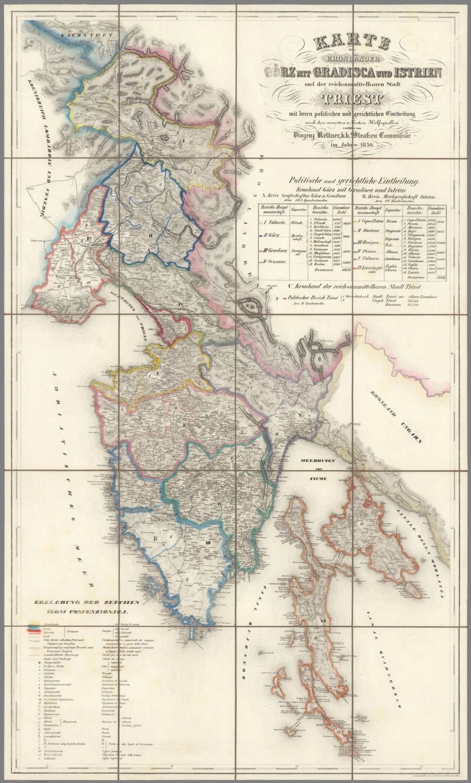
2. (Covers to) Karte der Kronländer Görz mit Gradisca und Istrien und der reichsunmittelbaren Stadt Triest mit deren politischen und gerichtlichen Eintheilungen nach den neuesten u. besten Hilfsquelllen verfaßt
- Author
-
Kettner, Vinzenz
- Subjects
- Vienna
- Abstract
"First edition, very rare (only the reprint from the Kronländer edition of the archive publisher is missing on the ÖNB). - The author Vinzenz Kettner published a similar map with the title "Map of the Imperial and Royal Coastal Land" around 1835 (identical in format and depicted area and also printed by Förster in Vienna) and there is apparently a preliminary drawing for this on the ÖNB the year 1830 with the title "Overview map of the Aerarial Post and Municipality of Strassen in Istria". A copy of the present card can be found in the catalog of the library of Charles University in Prague. Hardly any data can be found about the author himself (he can be found in army schematics). - The map extends from Bovec (Flitsch) in the north to Ilovik (Asinello or German Nebe) [small island south of Losinj / Lussino] in the south. The depicted coastline of the mainland extends from Grado via Trieste, Pula, Rijeka to Senj (Segna or German Zengg). Particular attention was paid to the large number of localities that have been drawn in, as well as the roads and the planned railroad. The representation of the mountains is not entirely successful. On the right under the title is a statistical table with the areas and inhabitants of the political districts." (Matthaeus Truppe, 2020) more...
- Published
- 1850
Catalog
Books, media, physical & digital resources
3. (Text Page to) Karte der Zu- und Abnahme der Bevölkerung Österreich-Ungarn's in dem Zeitraume 1869 bis 1880 / von Franz Ritter v. Le Monnier k. k. Ministerial-Vice-Secretär und General-Secretär der k. k. Geographischen Gesellschaft in Wien. (1)

- Author
-
Hölzel, Eduard, 1817-1885, Ed. Hölzel (Firm), Toula, Franz, 1845-1920, Chavanne, Josef, 1846-1902, and Ritter, Franz, -1932
- Subjects
- Vienna
- Abstract
Descriptive text to accompany Nr. 21, following map. Describes the distribution of population increase and decrease during the period from 1869 to 1880, based upon the census of December 31, 1880, for Austria-Hungary. With an historiated initial. Text spans two pages. Accompanying tables follow on subsequent page., Physikalisch-Statistischer Hand-Atlas von Osterreich-Ungarn, edited and executed by Eduard Hölzel's Geographical Institute in Vienna, 1887. Title translates to: Physical-statistical hand atlas of Austria-Hungary. Bound in green and black mottled board. With gilded title on front cover and spine. Back cover and verso of front cover both have bookplate: Hochschule für Bodenkultur Landw. Betriebslehre [University of Natural Resources and Life Sciences, Agricultural Management]. Bookplates stamped with "St 135". Includes a title page with an extended statement of responsibility, crediting contributors, as well as a table of contents, introductory text, and descriptive texts, with tables, following maps. Atlas comprised of twenty-five numbered plates, with two plates printed as 17. Plates present forty maps of the Austro-Hungarian Empire, as well as several additionally depicting Bosnia and Herzegovina. Volume divided into two parts: Physikalischer [= Physical] (plates 1-15) and Statistischer [= Statistical] (16-24). Physical maps feature physical phenomena such as rainfall, thunderstorms, geology, minerals, forest and flower distribution; statistical maps feature cultural geography, such as population, sex ratio, mother-tongues, administrative divisions, religious denominations and education levels. Maps also show political boundaries, cities, railways, roads, valleys, lakes, drainage, coastlines and islands. Maps include latitudinal and longitudinal lines, as well as legends. Maps showing human characteristics also utilize data visualization. Colored lithographs. more...
- Published
- 1887
4. (Text Page to) Karte der Vertheilung des Grossviehes auf die Fläche / von Dr. Franz Ritter von Le Monnier, k. k. Ministerial-Vicesecretär, Generalsectretär der Geographischen Gesellschaft in Wein. (2)

- Author
-
Hölzel, Eduard, 1817-1885, Ed. Hölzel (Firm), Toula, Franz, 1845-1920, Chavanne, Josef, 1846-1902, and Ritter, Franz, -1932
- Subjects
- Vienna
- Abstract
Descriptive text to accompany Nr. 23, following maps. Describes the distribution of horses, cattle, goats and sheep for Austria-Hungary. Includes table: Die Vertheilung des Viehstandes auf die Fläche [= The distribution of the livestock over the area]. Table spans four pages., Physikalisch-Statistischer Hand-Atlas von Osterreich-Ungarn, edited and executed by Eduard Hölzel's Geographical Institute in Vienna, 1887. Title translates to: Physical-statistical hand atlas of Austria-Hungary. Bound in green and black mottled board. With gilded title on front cover and spine. Back cover and verso of front cover both have bookplate: Hochschule für Bodenkultur Landw. Betriebslehre [University of Natural Resources and Life Sciences, Agricultural Management]. Bookplates stamped with "St 135". Includes a title page with an extended statement of responsibility, crediting contributors, as well as a table of contents, introductory text, and descriptive texts, with tables, following maps. Atlas comprised of twenty-five numbered plates, with two plates printed as 17. Plates present forty maps of the Austro-Hungarian Empire, as well as several additionally depicting Bosnia and Herzegovina. Volume divided into two parts: Physikalischer [= Physical] (plates 1-15) and Statistischer [= Statistical] (16-24). Physical maps feature physical phenomena such as rainfall, thunderstorms, geology, minerals, forest and flower distribution; statistical maps feature cultural geography, such as population, sex ratio, mother-tongues, administrative divisions, religious denominations and education levels. Maps also show political boundaries, cities, railways, roads, valleys, lakes, drainage, coastlines and islands. Maps include latitudinal and longitudinal lines, as well as legends. Maps showing human characteristics also utilize data visualization. Colored lithographs. more...
- Published
- 1887
5. (Text Page to) Das Geschlechts-Verhältniss der Bevölkerung Österreich-Ungarns / von Dr. Franz Ritter von Le Monnier k. k. Ministerial-Vice-Secretär und Bibliothekar der k. k. Geographischen Gesellschaft in Wien. (1)

- Author
-
Hölzel, Eduard, 1817-1885, Ed. Hölzel (Firm), Toula, Franz, 1845-1920, Chavanne, Josef, 1846-1902, and Ritter, Franz, -1932
- Subjects
- Vienna
- Abstract
Descriptive text to accompany Nr. 24, following map. Describes the distribution of population according to sex ratio, based upon the census of December 31, 1880, for Austria-Hungary. With an historiated initial. Includes tables. Text spans two pages., Physikalisch-Statistischer Hand-Atlas von Osterreich-Ungarn, edited and executed by Eduard Hölzel's Geographical Institute in Vienna, 1887. Title translates to: Physical-statistical hand atlas of Austria-Hungary. Bound in green and black mottled board. With gilded title on front cover and spine. Back cover and verso of front cover both have bookplate: Hochschule für Bodenkultur Landw. Betriebslehre [University of Natural Resources and Life Sciences, Agricultural Management]. Bookplates stamped with "St 135". Includes a title page with an extended statement of responsibility, crediting contributors, as well as a table of contents, introductory text, and descriptive texts, with tables, following maps. Atlas comprised of twenty-five numbered plates, with two plates printed as 17. Plates present forty maps of the Austro-Hungarian Empire, as well as several additionally depicting Bosnia and Herzegovina. Volume divided into two parts: Physikalischer [= Physical] (plates 1-15) and Statistischer [= Statistical] (16-24). Physical maps feature physical phenomena such as rainfall, thunderstorms, geology, minerals, forest and flower distribution; statistical maps feature cultural geography, such as population, sex ratio, mother-tongues, administrative divisions, religious denominations and education levels. Maps also show political boundaries, cities, railways, roads, valleys, lakes, drainage, coastlines and islands. Maps include latitudinal and longitudinal lines, as well as legends. Maps showing human characteristics also utilize data visualization. Colored lithographs. more...
- Published
- 1887
6. (Text Page to) Die Vertheilung der Hauptculturen in der Österr.-Ungarischen Monarchie / von Dr. Jos. Ritter Lorenz. von Lorenz-Liburnau. (3)

- Author
-
Hölzel, Eduard, 1817-1885, Ed. Hölzel (Firm), Toula, Franz, 1845-1920, Chavanne, Josef, 1846-1902, and Lorenz von Liburnau, Josef Roman, 1825-1911
- Subjects
- Vienna
- Abstract
Descriptive text to accompany Nr. 22, following maps. Describes the ratio of arable land, meadows, woods and wine country to the total productive area of each district for Austria-Hungary. Includes tables: Oestliche Reichschälfte [= Eastern half of the empire] -- Maximal-Procente der productiven Fläche von [= Maximum percent of the productive area of ... ] -- Minimal-Procente der productiven Fläche von [= Minimum percent of the productive area of ... ]., Physikalisch-Statistischer Hand-Atlas von Osterreich-Ungarn, edited and executed by Eduard Hölzel's Geographical Institute in Vienna, 1887. Title translates to: Physical-statistical hand atlas of Austria-Hungary. Bound in green and black mottled board. With gilded title on front cover and spine. Back cover and verso of front cover both have bookplate: Hochschule für Bodenkultur Landw. Betriebslehre [University of Natural Resources and Life Sciences, Agricultural Management]. Bookplates stamped with "St 135". Includes a title page with an extended statement of responsibility, crediting contributors, as well as a table of contents, introductory text, and descriptive texts, with tables, following maps. Atlas comprised of twenty-five numbered plates, with two plates printed as 17. Plates present forty maps of the Austro-Hungarian Empire, as well as several additionally depicting Bosnia and Herzegovina. Volume divided into two parts: Physikalischer [= Physical] (plates 1-15) and Statistischer [= Statistical] (16-24). Physical maps feature physical phenomena such as rainfall, thunderstorms, geology, minerals, forest and flower distribution; statistical maps feature cultural geography, such as population, sex ratio, mother-tongues, administrative divisions, religious denominations and education levels. Maps also show political boundaries, cities, railways, roads, valleys, lakes, drainage, coastlines and islands. Maps include latitudinal and longitudinal lines, as well as legends. Maps showing human characteristics also utilize data visualization. Colored lithographs. more...
- Published
- 1887
7. (Text Page to) Karte der Vertheilung des Grossviehes auf die Fläche / von Dr. Franz Ritter von Le Monnier, k. k. Ministerial-Vicesecretär, Generalsectretär der Geographischen Gesellschaft in Wein. (3)

- Author
-
Hölzel, Eduard, 1817-1885, Ed. Hölzel (Firm), Toula, Franz, 1845-1920, Chavanne, Josef, 1846-1902, and Ritter, Franz, -1932
- Subjects
- Vienna
- Abstract
Descriptive text to accompany Nr. 23, following maps. Describes the distribution of horses, cattle, goats and sheep for Austria-Hungary. Includes table: Länder der ungarischen Krone [= Countries of the Hungarian crown]. Tables spans four pages., Physikalisch-Statistischer Hand-Atlas von Osterreich-Ungarn, edited and executed by Eduard Hölzel's Geographical Institute in Vienna, 1887. Title translates to: Physical-statistical hand atlas of Austria-Hungary. Bound in green and black mottled board. With gilded title on front cover and spine. Back cover and verso of front cover both have bookplate: Hochschule für Bodenkultur Landw. Betriebslehre [University of Natural Resources and Life Sciences, Agricultural Management]. Bookplates stamped with "St 135". Includes a title page with an extended statement of responsibility, crediting contributors, as well as a table of contents, introductory text, and descriptive texts, with tables, following maps. Atlas comprised of twenty-five numbered plates, with two plates printed as 17. Plates present forty maps of the Austro-Hungarian Empire, as well as several additionally depicting Bosnia and Herzegovina. Volume divided into two parts: Physikalischer [= Physical] (plates 1-15) and Statistischer [= Statistical] (16-24). Physical maps feature physical phenomena such as rainfall, thunderstorms, geology, minerals, forest and flower distribution; statistical maps feature cultural geography, such as population, sex ratio, mother-tongues, administrative divisions, religious denominations and education levels. Maps also show political boundaries, cities, railways, roads, valleys, lakes, drainage, coastlines and islands. Maps include latitudinal and longitudinal lines, as well as legends. Maps showing human characteristics also utilize data visualization. Colored lithographs. more...
- Published
- 1887
8. (Text Page to) Das Geschlechts-Verhältniss der Bevölkerung Österreich-Ungarns / von Dr. Franz Ritter von Le Monnier k. k. Ministerial-Vice-Secretär und Bibliothekar der k. k. Geographischen Gesellschaft in Wien. (2)

- Author
-
Hölzel, Eduard, 1817-1885, Ed. Hölzel (Firm), Toula, Franz, 1845-1920, Chavanne, Josef, 1846-1902, and Ritter, Franz, -1932
- Subjects
- Vienna
- Abstract
Descriptive text to accompany Nr. 24, following map. Describes the distribution of population according to sex ratio, based upon the census of December 31, 1880, for Austria-Hungary. Includes tables, such as: Numerisches Verhältniss der Geschlechter in den Städten : Zahl der Frauen auf 1000 Männer [= Numerical ratio of the sexes in the cities: number of women per 1000 men]. Text spans two pages., Physikalisch-Statistischer Hand-Atlas von Osterreich-Ungarn, edited and executed by Eduard Hölzel's Geographical Institute in Vienna, 1887. Title translates to: Physical-statistical hand atlas of Austria-Hungary. Bound in green and black mottled board. With gilded title on front cover and spine. Back cover and verso of front cover both have bookplate: Hochschule für Bodenkultur Landw. Betriebslehre [University of Natural Resources and Life Sciences, Agricultural Management]. Bookplates stamped with "St 135". Includes a title page with an extended statement of responsibility, crediting contributors, as well as a table of contents, introductory text, and descriptive texts, with tables, following maps. Atlas comprised of twenty-five numbered plates, with two plates printed as 17. Plates present forty maps of the Austro-Hungarian Empire, as well as several additionally depicting Bosnia and Herzegovina. Volume divided into two parts: Physikalischer [= Physical] (plates 1-15) and Statistischer [= Statistical] (16-24). Physical maps feature physical phenomena such as rainfall, thunderstorms, geology, minerals, forest and flower distribution; statistical maps feature cultural geography, such as population, sex ratio, mother-tongues, administrative divisions, religious denominations and education levels. Maps also show political boundaries, cities, railways, roads, valleys, lakes, drainage, coastlines and islands. Maps include latitudinal and longitudinal lines, as well as legends. Maps showing human characteristics also utilize data visualization. Colored lithographs. more...
- Published
- 1887
9. (Text Page to) Die Vertheilung der Hauptculturen in der Österr.-Ungarischen Monarchie / von Dr. Jos. Ritter Lorenz. von Lorenz-Liburnau. (1)

- Author
-
Hölzel, Eduard, 1817-1885, Ed. Hölzel (Firm), Toula, Franz, 1845-1920, Chavanne, Josef, 1846-1902, and Lorenz von Liburnau, Josef Roman, 1825-1911
- Subjects
- Vienna
- Abstract
Descriptive text to accompany Nr. 22, following maps. Describes the ratio of arable land, meadows, woods and wine country to the total productive area of each district for Austria-Hungary. With an historiated initial. Accompanying tables follow on subsequent pages., Physikalisch-Statistischer Hand-Atlas von Osterreich-Ungarn, edited and executed by Eduard Hölzel's Geographical Institute in Vienna, 1887. Title translates to: Physical-statistical hand atlas of Austria-Hungary. Bound in green and black mottled board. With gilded title on front cover and spine. Back cover and verso of front cover both have bookplate: Hochschule für Bodenkultur Landw. Betriebslehre [University of Natural Resources and Life Sciences, Agricultural Management]. Bookplates stamped with "St 135". Includes a title page with an extended statement of responsibility, crediting contributors, as well as a table of contents, introductory text, and descriptive texts, with tables, following maps. Atlas comprised of twenty-five numbered plates, with two plates printed as 17. Plates present forty maps of the Austro-Hungarian Empire, as well as several additionally depicting Bosnia and Herzegovina. Volume divided into two parts: Physikalischer [= Physical] (plates 1-15) and Statistischer [= Statistical] (16-24). Physical maps feature physical phenomena such as rainfall, thunderstorms, geology, minerals, forest and flower distribution; statistical maps feature cultural geography, such as population, sex ratio, mother-tongues, administrative divisions, religious denominations and education levels. Maps also show political boundaries, cities, railways, roads, valleys, lakes, drainage, coastlines and islands. Maps include latitudinal and longitudinal lines, as well as legends. Maps showing human characteristics also utilize data visualization. Colored lithographs. more...
- Published
- 1887
10. (Text Page to) Karte der Dichtigkeit der Bevölkerung von Oesterreich-Ungarn auf Grund der Ergebnisse der Volkszählung vom 31 Dezember 1880 / von Dr. Franz Ritter von Le Monnier. (1)

- Author
-
Hölzel, Eduard, 1817-1885, Ed. Hölzel (Firm), Toula, Franz, 1845-1920, Chavanne, Josef, 1846-1902, and Ritter, Franz, -1932
- Subjects
- Vienna
- Abstract
Descriptive text to accompany Nr. 19, following map. Describes the distribution of population, based upon the census from December 31, 1880, for Austria-Hungary. With an historiated initial. Includes table: Volksdichtigkeit der Gerichtsbezirke Oesterreichs nach der Volkszählung vom 31. December 1880 [= Population density of the judicial districts of Austria according to the census of December 31, 1880]. Table spans three pages., Physikalisch-Statistischer Hand-Atlas von Osterreich-Ungarn, edited and executed by Eduard Hölzel's Geographical Institute in Vienna, 1887. Title translates to: Physical-statistical hand atlas of Austria-Hungary. Bound in green and black mottled board. With gilded title on front cover and spine. Back cover and verso of front cover both have bookplate: Hochschule für Bodenkultur Landw. Betriebslehre [University of Natural Resources and Life Sciences, Agricultural Management]. Bookplates stamped with "St 135". Includes a title page with an extended statement of responsibility, crediting contributors, as well as a table of contents, introductory text, and descriptive texts, with tables, following maps. Atlas comprised of twenty-five numbered plates, with two plates printed as 17. Plates present forty maps of the Austro-Hungarian Empire, as well as several additionally depicting Bosnia and Herzegovina. Volume divided into two parts: Physikalischer [= Physical] (plates 1-15) and Statistischer [= Statistical] (16-24). Physical maps feature physical phenomena such as rainfall, thunderstorms, geology, minerals, forest and flower distribution; statistical maps feature cultural geography, such as population, sex ratio, mother-tongues, administrative divisions, religious denominations and education levels. Maps also show political boundaries, cities, railways, roads, valleys, lakes, drainage, coastlines and islands. Maps include latitudinal and longitudinal lines, as well as legends. Maps showing human characteristics also utilize data visualization. Colored lithographs. more...
- Published
- 1887
11. (Text Page to) Die Vertheilung der Hauptculturen in der Österr.-Ungarischen Monarchie / von Dr. Jos. Ritter Lorenz. von Lorenz-Liburnau. (2)

- Author
-
Hölzel, Eduard, 1817-1885, Ed. Hölzel (Firm), Toula, Franz, 1845-1920, Chavanne, Josef, 1846-1902, and Lorenz von Liburnau, Josef Roman, 1825-1911
- Subjects
- Vienna
- Abstract
Descriptive text to accompany Nr. 22, following maps. Describes the ratio of arable land, meadows, woods and wine country to the total productive area of each district for Austria-Hungary. Includes table: Westliche Reichschälfte [= Western half of the empire]., Physikalisch-Statistischer Hand-Atlas von Osterreich-Ungarn, edited and executed by Eduard Hölzel's Geographical Institute in Vienna, 1887. Title translates to: Physical-statistical hand atlas of Austria-Hungary. Bound in green and black mottled board. With gilded title on front cover and spine. Back cover and verso of front cover both have bookplate: Hochschule für Bodenkultur Landw. Betriebslehre [University of Natural Resources and Life Sciences, Agricultural Management]. Bookplates stamped with "St 135". Includes a title page with an extended statement of responsibility, crediting contributors, as well as a table of contents, introductory text, and descriptive texts, with tables, following maps. Atlas comprised of twenty-five numbered plates, with two plates printed as 17. Plates present forty maps of the Austro-Hungarian Empire, as well as several additionally depicting Bosnia and Herzegovina. Volume divided into two parts: Physikalischer [= Physical] (plates 1-15) and Statistischer [= Statistical] (16-24). Physical maps feature physical phenomena such as rainfall, thunderstorms, geology, minerals, forest and flower distribution; statistical maps feature cultural geography, such as population, sex ratio, mother-tongues, administrative divisions, religious denominations and education levels. Maps also show political boundaries, cities, railways, roads, valleys, lakes, drainage, coastlines and islands. Maps include latitudinal and longitudinal lines, as well as legends. Maps showing human characteristics also utilize data visualization. Colored lithographs. more...
- Published
- 1887
12. (Text Page to) Karte der Zu- und Abnahme der Bevölkerung Österreich-Ungarn's in dem Zeitraume 1869 bis 1880 / von Franz Ritter v. Le Monnier k. k. Ministerial-Vice-Secretär und General-Secretär der k. k. Geographischen Gesellschaft in Wien. (2)

- Author
-
Hölzel, Eduard, 1817-1885, Ed. Hölzel (Firm), Toula, Franz, 1845-1920, Chavanne, Josef, 1846-1902, and Ritter, Franz, -1932
- Subjects
- Vienna
- Abstract
Descriptive text to accompany Nr. 21, following map. Describes the distribution of population increase and decrease during the period from 1869 to 1880, based upon the census of December 31, 1880, for Austria-Hungary. Text spans two pages. Includes tables, such as: Jährliche Volkszunahme in den Staaten Europas in Percenten [= Annual population increase in the countries of Europe in percent]., Physikalisch-Statistischer Hand-Atlas von Osterreich-Ungarn, edited and executed by Eduard Hölzel's Geographical Institute in Vienna, 1887. Title translates to: Physical-statistical hand atlas of Austria-Hungary. Bound in green and black mottled board. With gilded title on front cover and spine. Back cover and verso of front cover both have bookplate: Hochschule für Bodenkultur Landw. Betriebslehre [University of Natural Resources and Life Sciences, Agricultural Management]. Bookplates stamped with "St 135". Includes a title page with an extended statement of responsibility, crediting contributors, as well as a table of contents, introductory text, and descriptive texts, with tables, following maps. Atlas comprised of twenty-five numbered plates, with two plates printed as 17. Plates present forty maps of the Austro-Hungarian Empire, as well as several additionally depicting Bosnia and Herzegovina. Volume divided into two parts: Physikalischer [= Physical] (plates 1-15) and Statistischer [= Statistical] (16-24). Physical maps feature physical phenomena such as rainfall, thunderstorms, geology, minerals, forest and flower distribution; statistical maps feature cultural geography, such as population, sex ratio, mother-tongues, administrative divisions, religious denominations and education levels. Maps also show political boundaries, cities, railways, roads, valleys, lakes, drainage, coastlines and islands. Maps include latitudinal and longitudinal lines, as well as legends. Maps showing human characteristics also utilize data visualization. Colored lithographs. more...
- Published
- 1887
13. (Text Page to) Karte des mittleren und höheren Unterrichts, sowie der Elementarbildung der Bevölkerung in Oesterreich-Ungarn / von Franz Ritter von Le Monnier, k. k. Ministerial-Concipist und Bibliothekar der k. k. Geographischen Gesellschaft in Wien. (1)

- Author
-
Hölzel, Eduard, 1817-1885, Ed. Hölzel (Firm), Toula, Franz, 1845-1920, Chavanne, Josef, 1846-1902, and Ritter, Franz, -1932
- Subjects
- Vienna
- Abstract
Descriptive text to accompany Nr. 18, following map. Describes the distribution of education levels for Austria-Hungary. With an historiated initial. Includes tables, such as: Das Volksschulwesen [= The elementary school system]. Text and tables span two pages., Physikalisch-Statistischer Hand-Atlas von Osterreich-Ungarn, edited and executed by Eduard Hölzel's Geographical Institute in Vienna, 1887. Title translates to: Physical-statistical hand atlas of Austria-Hungary. Bound in green and black mottled board. With gilded title on front cover and spine. Back cover and verso of front cover both have bookplate: Hochschule für Bodenkultur Landw. Betriebslehre [University of Natural Resources and Life Sciences, Agricultural Management]. Bookplates stamped with "St 135". Includes a title page with an extended statement of responsibility, crediting contributors, as well as a table of contents, introductory text, and descriptive texts, with tables, following maps. Atlas comprised of twenty-five numbered plates, with two plates printed as 17. Plates present forty maps of the Austro-Hungarian Empire, as well as several additionally depicting Bosnia and Herzegovina. Volume divided into two parts: Physikalischer [= Physical] (plates 1-15) and Statistischer [= Statistical] (16-24). Physical maps feature physical phenomena such as rainfall, thunderstorms, geology, minerals, forest and flower distribution; statistical maps feature cultural geography, such as population, sex ratio, mother-tongues, administrative divisions, religious denominations and education levels. Maps also show political boundaries, cities, railways, roads, valleys, lakes, drainage, coastlines and islands. Maps include latitudinal and longitudinal lines, as well as legends. Maps showing human characteristics also utilize data visualization. Colored lithographs. more...
- Published
- 1887
14. (Text Page to) Karte der Vertheilung des Grossviehes auf die Fläche / von Dr. Franz Ritter von Le Monnier, k. k. Ministerial-Vicesecretär, Generalsectretär der Geographischen Gesellschaft in Wein. (1)

- Author
-
Hölzel, Eduard, 1817-1885, Ed. Hölzel (Firm), Toula, Franz, 1845-1920, Chavanne, Josef, 1846-1902, and Ritter, Franz, -1932
- Subjects
- Vienna
- Abstract
Descriptive text to accompany Nr. 23, following maps. Describes the distribution of horses, cattle, goats and sheep for Austria-Hungary. With an historiated initial. Includes table: Die Vertheilung des Viehstandes auf die Fläche [= The distribution of the livestock over the area]. Table spans four pages., Physikalisch-Statistischer Hand-Atlas von Osterreich-Ungarn, edited and executed by Eduard Hölzel's Geographical Institute in Vienna, 1887. Title translates to: Physical-statistical hand atlas of Austria-Hungary. Bound in green and black mottled board. With gilded title on front cover and spine. Back cover and verso of front cover both have bookplate: Hochschule für Bodenkultur Landw. Betriebslehre [University of Natural Resources and Life Sciences, Agricultural Management]. Bookplates stamped with "St 135". Includes a title page with an extended statement of responsibility, crediting contributors, as well as a table of contents, introductory text, and descriptive texts, with tables, following maps. Atlas comprised of twenty-five numbered plates, with two plates printed as 17. Plates present forty maps of the Austro-Hungarian Empire, as well as several additionally depicting Bosnia and Herzegovina. Volume divided into two parts: Physikalischer [= Physical] (plates 1-15) and Statistischer [= Statistical] (16-24). Physical maps feature physical phenomena such as rainfall, thunderstorms, geology, minerals, forest and flower distribution; statistical maps feature cultural geography, such as population, sex ratio, mother-tongues, administrative divisions, religious denominations and education levels. Maps also show political boundaries, cities, railways, roads, valleys, lakes, drainage, coastlines and islands. Maps include latitudinal and longitudinal lines, as well as legends. Maps showing human characteristics also utilize data visualization. Colored lithographs. more...
- Published
- 1887
15. (Text Page to) Karte der Vertheilung der Orte in Österreich-Ungarn / von Franz Ritter von Le Monnier, k. k. Ministerial-Concipist und Bibliothekar der k. k. Geographischen Gesellschaft in Wien. (2)

- Author
-
Hölzel, Eduard, 1817-1885, Ed. Hölzel (Firm), Toula, Franz, 1845-1920, Chavanne, Josef, 1846-1902, and Ritter, Franz, -1932
- Subjects
- Vienna
- Abstract
Descriptive text to accompany Nr. 20, following map. Describes the distribution of population, according to of the local communities with 2,000 inhabitants, for Austria-Hungary. Includes tables: Anzahl der Ortsgemeinden über 2000 Einwohner [= Number of local parishes over 2,000 inhabitants] -- Zahl der Einwohner in den Ortschaften über 2000 Einwohner [= Number of inhabitants in the localities over 2,000 inhabitants] -- Zahl der Häuser in Oesterreich-Ungarn [= Number of houses in Austria-Hungary] -- Die Zahl der Häuser und Wohnparteien in den grösseren Städten der Monarchie [= The number of houses and tenants in the larger cities of the monarchy]. Tables span two pages., Physikalisch-Statistischer Hand-Atlas von Osterreich-Ungarn, edited and executed by Eduard Hölzel's Geographical Institute in Vienna, 1887. Title translates to: Physical-statistical hand atlas of Austria-Hungary. Bound in green and black mottled board. With gilded title on front cover and spine. Back cover and verso of front cover both have bookplate: Hochschule für Bodenkultur Landw. Betriebslehre [University of Natural Resources and Life Sciences, Agricultural Management]. Bookplates stamped with "St 135". Includes a title page with an extended statement of responsibility, crediting contributors, as well as a table of contents, introductory text, and descriptive texts, with tables, following maps. Atlas comprised of twenty-five numbered plates, with two plates printed as 17. Plates present forty maps of the Austro-Hungarian Empire, as well as several additionally depicting Bosnia and Herzegovina. Volume divided into two parts: Physikalischer [= Physical] (plates 1-15) and Statistischer [= Statistical] (16-24). Physical maps feature physical phenomena such as rainfall, thunderstorms, geology, minerals, forest and flower distribution; statistical maps feature cultural geography, such as population, sex ratio, mother-tongues, administrative divisions, religious denominations and education levels. Maps also show political boundaries, cities, railways, roads, valleys, lakes, drainage, coastlines and islands. Maps include latitudinal and longitudinal lines, as well as legends. Maps showing human characteristics also utilize data visualization. Colored lithographs. more...
- Published
- 1887
16. (Text Page to) Karte der Territorial-Eintheilung des K. K. Heeres und der beiden Landwehren, der Vertheilung der Garnisonen und des Verhältnisses der Kriegsdiensttauglichkeit / von Franz Ritter von Le Monnier k. k. Ministerial-Concipist und Bibliothekar der k. k. Geographischen Gesellschaft in Wien. (2)

- Author
-
Hölzel, Eduard, 1817-1885, Ed. Hölzel (Firm), Toula, Franz, 1845-1920, Chavanne, Josef, 1846-1902, and Ritter, Franz, -1932
- Subjects
- Vienna
- Abstract
Descriptive text to accompany Nr. 17, following maps. Describes the distribution of military bases for Austria-Hungary. Includes tables: Die Confessionen im Heere [= The religious denominations in the Army] -- Das Officierscorps : a) Generalität und Oberste -- b) Stabs- und Ober-Officiere, Cadetten [= The officer corps: a) Generals and colonels - b) Staff and senior officers, cadets]. Text and tables span four pages., Physikalisch-Statistischer Hand-Atlas von Osterreich-Ungarn, edited and executed by Eduard Hölzel's Geographical Institute in Vienna, 1887. Title translates to: Physical-statistical hand atlas of Austria-Hungary. Bound in green and black mottled board. With gilded title on front cover and spine. Back cover and verso of front cover both have bookplate: Hochschule für Bodenkultur Landw. Betriebslehre [University of Natural Resources and Life Sciences, Agricultural Management]. Bookplates stamped with "St 135". Includes a title page with an extended statement of responsibility, crediting contributors, as well as a table of contents, introductory text, and descriptive texts, with tables, following maps. Atlas comprised of twenty-five numbered plates, with two plates printed as 17. Plates present forty maps of the Austro-Hungarian Empire, as well as several additionally depicting Bosnia and Herzegovina. Volume divided into two parts: Physikalischer [= Physical] (plates 1-15) and Statistischer [= Statistical] (16-24). Physical maps feature physical phenomena such as rainfall, thunderstorms, geology, minerals, forest and flower distribution; statistical maps feature cultural geography, such as population, sex ratio, mother-tongues, administrative divisions, religious denominations and education levels. Maps also show political boundaries, cities, railways, roads, valleys, lakes, drainage, coastlines and islands. Maps include latitudinal and longitudinal lines, as well as legends. Maps showing human characteristics also utilize data visualization. Colored lithographs. more...
- Published
- 1887
17. (Text Page to) Karte der Vertheilung der Orte in Österreich-Ungarn / von Franz Ritter von Le Monnier, k. k. Ministerial-Concipist und Bibliothekar der k. k. Geographischen Gesellschaft in Wien. (1)

- Author
-
Hölzel, Eduard, 1817-1885, Ed. Hölzel (Firm), Toula, Franz, 1845-1920, Chavanne, Josef, 1846-1902, and Ritter, Franz, -1932
- Subjects
- Vienna
- Abstract
Descriptive text to accompany Nr. 20, following map. Describes the distribution of population, according to of the local communities with 2,000 inhabitants, for Austria-Hungary. With an historiated initial. Includes tables. Tables span two pages., Physikalisch-Statistischer Hand-Atlas von Osterreich-Ungarn, edited and executed by Eduard Hölzel's Geographical Institute in Vienna, 1887. Title translates to: Physical-statistical hand atlas of Austria-Hungary. Bound in green and black mottled board. With gilded title on front cover and spine. Back cover and verso of front cover both have bookplate: Hochschule für Bodenkultur Landw. Betriebslehre [University of Natural Resources and Life Sciences, Agricultural Management]. Bookplates stamped with "St 135". Includes a title page with an extended statement of responsibility, crediting contributors, as well as a table of contents, introductory text, and descriptive texts, with tables, following maps. Atlas comprised of twenty-five numbered plates, with two plates printed as 17. Plates present forty maps of the Austro-Hungarian Empire, as well as several additionally depicting Bosnia and Herzegovina. Volume divided into two parts: Physikalischer [= Physical] (plates 1-15) and Statistischer [= Statistical] (16-24). Physical maps feature physical phenomena such as rainfall, thunderstorms, geology, minerals, forest and flower distribution; statistical maps feature cultural geography, such as population, sex ratio, mother-tongues, administrative divisions, religious denominations and education levels. Maps also show political boundaries, cities, railways, roads, valleys, lakes, drainage, coastlines and islands. Maps include latitudinal and longitudinal lines, as well as legends. Maps showing human characteristics also utilize data visualization. Colored lithographs. more...
- Published
- 1887
18. (Text Page to) Karte der Dichtigkeit der Bevölkerung von Oesterreich-Ungarn auf Grund der Ergebnisse der Volkszählung vom 31 Dezember 1880 / von Dr. Franz Ritter von Le Monnier. (2)

- Author
-
Hölzel, Eduard, 1817-1885, Ed. Hölzel (Firm), Toula, Franz, 1845-1920, Chavanne, Josef, 1846-1902, and Ritter, Franz, -1932
- Subjects
- Vienna
- Abstract
Descriptive text to accompany Nr. 19, following map. Describes the distribution of population, based upon the census from December 31, 1880, for Austria-Hungary. Includes table: Volksdichtigkeit der Gerichtsbezirke Oesterreichs nach der Volkszählung vom 31. December 1880 [= Population density of the judicial districts of Austria according to the census of December 31, 1880]. Table spans three pages., Physikalisch-Statistischer Hand-Atlas von Osterreich-Ungarn, edited and executed by Eduard Hölzel's Geographical Institute in Vienna, 1887. Title translates to: Physical-statistical hand atlas of Austria-Hungary. Bound in green and black mottled board. With gilded title on front cover and spine. Back cover and verso of front cover both have bookplate: Hochschule für Bodenkultur Landw. Betriebslehre [University of Natural Resources and Life Sciences, Agricultural Management]. Bookplates stamped with "St 135". Includes a title page with an extended statement of responsibility, crediting contributors, as well as a table of contents, introductory text, and descriptive texts, with tables, following maps. Atlas comprised of twenty-five numbered plates, with two plates printed as 17. Plates present forty maps of the Austro-Hungarian Empire, as well as several additionally depicting Bosnia and Herzegovina. Volume divided into two parts: Physikalischer [= Physical] (plates 1-15) and Statistischer [= Statistical] (16-24). Physical maps feature physical phenomena such as rainfall, thunderstorms, geology, minerals, forest and flower distribution; statistical maps feature cultural geography, such as population, sex ratio, mother-tongues, administrative divisions, religious denominations and education levels. Maps also show political boundaries, cities, railways, roads, valleys, lakes, drainage, coastlines and islands. Maps include latitudinal and longitudinal lines, as well as legends. Maps showing human characteristics also utilize data visualization. Colored lithographs. more...
- Published
- 1887
19. (Text Page to) Karte der Verbreitung Nutzbarer Mineralien in der Öesterreichisch-Ungarischen Monarchie / von Dr. Franz Toula, k. k. Professor an der technischen Hochschule in Wien. (3)

- Author
-
Hölzel, Eduard, 1817-1885, Ed. Hölzel (Firm), Toula, Franz, 1845-1920, and Chavanne, Josef, 1846-1902
- Subjects
- Vienna
- Abstract
Descriptive text to accompany Nr. 12, following map. Describes the distribution of mineral resources for Austria-Hungary. Text spans four pages. Includes a table., Physikalisch-Statistischer Hand-Atlas von Osterreich-Ungarn, edited and executed by Eduard Hölzel's Geographical Institute in Vienna, 1887. Title translates to: Physical-statistical hand atlas of Austria-Hungary. Bound in green and black mottled board. With gilded title on front cover and spine. Back cover and verso of front cover both have bookplate: Hochschule für Bodenkultur Landw. Betriebslehre [University of Natural Resources and Life Sciences, Agricultural Management]. Bookplates stamped with "St 135". Includes a title page with an extended statement of responsibility, crediting contributors, as well as a table of contents, introductory text, and descriptive texts, with tables, following maps. Atlas comprised of twenty-five numbered plates, with two plates printed as 17. Plates present forty maps of the Austro-Hungarian Empire, as well as several additionally depicting Bosnia and Herzegovina. Volume divided into two parts: Physikalischer [= Physical] (plates 1-15) and Statistischer [= Statistical] (16-24). Physical maps feature physical phenomena such as rainfall, thunderstorms, geology, minerals, forest and flower distribution; statistical maps feature cultural geography, such as population, sex ratio, mother-tongues, administrative divisions, religious denominations and education levels. Maps also show political boundaries, cities, railways, roads, valleys, lakes, drainage, coastlines and islands. Maps include latitudinal and longitudinal lines, as well as legends. Maps showing human characteristics also utilize data visualization. Colored lithographs. more...
- Published
- 1887
20. (Text Page to) Karte der Vertheilung der Confession / von Franz Ritter von Le Monnier k. k. Ministerial-Concipist und Bibliothekar der k. k. Geographischen Gesellschaft in Wien. (2)

- Author
-
Hölzel, Eduard, 1817-1885, Ed. Hölzel (Firm), Toula, Franz, 1845-1920, Chavanne, Josef, 1846-1902, and Ritter, Franz, -1932
- Subjects
- Vienna
- Abstract
Descriptive text to accompany Nr. 16, following maps. Describes the distribution of religious denominations for Austria-Hungary. Includes tables: Verhältniss der Griechisch-Unirten zu den Römisch-Katholischen [= Relation of the Greek Universities to the Roman Catholics] -- Bezirke mit gemischter evangelischer Bevölkerung [= Districts with a mixed Protestant population] -- Israeliten [= Israelites]. Text and tables span three pages., Physikalisch-Statistischer Hand-Atlas von Osterreich-Ungarn, edited and executed by Eduard Hölzel's Geographical Institute in Vienna, 1887. Title translates to: Physical-statistical hand atlas of Austria-Hungary. Bound in green and black mottled board. With gilded title on front cover and spine. Back cover and verso of front cover both have bookplate: Hochschule für Bodenkultur Landw. Betriebslehre [University of Natural Resources and Life Sciences, Agricultural Management]. Bookplates stamped with "St 135". Includes a title page with an extended statement of responsibility, crediting contributors, as well as a table of contents, introductory text, and descriptive texts, with tables, following maps. Atlas comprised of twenty-five numbered plates, with two plates printed as 17. Plates present forty maps of the Austro-Hungarian Empire, as well as several additionally depicting Bosnia and Herzegovina. Volume divided into two parts: Physikalischer [= Physical] (plates 1-15) and Statistischer [= Statistical] (16-24). Physical maps feature physical phenomena such as rainfall, thunderstorms, geology, minerals, forest and flower distribution; statistical maps feature cultural geography, such as population, sex ratio, mother-tongues, administrative divisions, religious denominations and education levels. Maps also show political boundaries, cities, railways, roads, valleys, lakes, drainage, coastlines and islands. Maps include latitudinal and longitudinal lines, as well as legends. Maps showing human characteristics also utilize data visualization. Colored lithographs. more...
- Published
- 1887
21. (Text Page to) Karte des mittleren und höheren Unterrichts, sowie der Elementarbildung der Bevölkerung in Oesterreich-Ungarn / von Franz Ritter von Le Monnier, k. k. Ministerial-Concipist und Bibliothekar der k. k. Geographischen Gesellschaft in Wien. (2)

- Author
-
Hölzel, Eduard, 1817-1885, Ed. Hölzel (Firm), Toula, Franz, 1845-1920, Chavanne, Josef, 1846-1902, and Ritter, Franz, -1932
- Subjects
- Vienna
- Abstract
Descriptive text to accompany Nr. 18, following map. Describes the distribution of education levels for Austria-Hungary. Includes tables, such as: Die Mittelschulen [= The middle schools]. Text and tables span two pages., Physikalisch-Statistischer Hand-Atlas von Osterreich-Ungarn, edited and executed by Eduard Hölzel's Geographical Institute in Vienna, 1887. Title translates to: Physical-statistical hand atlas of Austria-Hungary. Bound in green and black mottled board. With gilded title on front cover and spine. Back cover and verso of front cover both have bookplate: Hochschule für Bodenkultur Landw. Betriebslehre [University of Natural Resources and Life Sciences, Agricultural Management]. Bookplates stamped with "St 135". Includes a title page with an extended statement of responsibility, crediting contributors, as well as a table of contents, introductory text, and descriptive texts, with tables, following maps. Atlas comprised of twenty-five numbered plates, with two plates printed as 17. Plates present forty maps of the Austro-Hungarian Empire, as well as several additionally depicting Bosnia and Herzegovina. Volume divided into two parts: Physikalischer [= Physical] (plates 1-15) and Statistischer [= Statistical] (16-24). Physical maps feature physical phenomena such as rainfall, thunderstorms, geology, minerals, forest and flower distribution; statistical maps feature cultural geography, such as population, sex ratio, mother-tongues, administrative divisions, religious denominations and education levels. Maps also show political boundaries, cities, railways, roads, valleys, lakes, drainage, coastlines and islands. Maps include latitudinal and longitudinal lines, as well as legends. Maps showing human characteristics also utilize data visualization. Colored lithographs. more...
- Published
- 1887
22. (Text Page to) Karte der Vertheilung der Bevölkerung Öesterreich-Ungarns nach der Umgangs-, beziehungsweise Muttersprache, auf Grund der Ergebnisse der Volkszählung vom 31. December 1880 / von Franz Ritter v. Le Monnier k. k. Ministerial-Vice-Secretär und General-Secretär der k. k. Geographischen Gesellschaft in Wien. (2)

- Author
-
Hölzel, Eduard, 1817-1885, Ed. Hölzel (Firm), Toula, Franz, 1845-1920, Chavanne, Josef, 1846-1902, and Ritter, Franz, -1932
- Subjects
- Vienna
- Abstract
Descriptive text to accompany Nr. 15, following map. Describes the distribution of mother-tongues for Austria-Hungary. Text spans two pages. Includes two tables: Anwesende einheimische Bevölkerung nach der Umgangs-, beziehungsweise Muttersprache, am 31. December 1880 in den einzelnen Kronländern : a) In absoluten Zahlen -- b) In Percenten [= Local population present in the mother tongue on December 31, 1880 : a) In absolute numbers - b) In percentages]., Physikalisch-Statistischer Hand-Atlas von Osterreich-Ungarn, edited and executed by Eduard Hölzel's Geographical Institute in Vienna, 1887. Title translates to: Physical-statistical hand atlas of Austria-Hungary. Bound in green and black mottled board. With gilded title on front cover and spine. Back cover and verso of front cover both have bookplate: Hochschule für Bodenkultur Landw. Betriebslehre [University of Natural Resources and Life Sciences, Agricultural Management]. Bookplates stamped with "St 135". Includes a title page with an extended statement of responsibility, crediting contributors, as well as a table of contents, introductory text, and descriptive texts, with tables, following maps. Atlas comprised of twenty-five numbered plates, with two plates printed as 17. Plates present forty maps of the Austro-Hungarian Empire, as well as several additionally depicting Bosnia and Herzegovina. Volume divided into two parts: Physikalischer [= Physical] (plates 1-15) and Statistischer [= Statistical] (16-24). Physical maps feature physical phenomena such as rainfall, thunderstorms, geology, minerals, forest and flower distribution; statistical maps feature cultural geography, such as population, sex ratio, mother-tongues, administrative divisions, religious denominations and education levels. Maps also show political boundaries, cities, railways, roads, valleys, lakes, drainage, coastlines and islands. Maps include latitudinal and longitudinal lines, as well as legends. Maps showing human characteristics also utilize data visualization. Colored lithographs. more...
- Published
- 1887
23. (Text Page to) Karte der Territorial-Eintheilung des K. K. Heeres und der beiden Landwehren, der Vertheilung der Garnisonen und des Verhältnisses der Kriegsdiensttauglichkeit / von Franz Ritter von Le Monnier k. k. Ministerial-Concipist und Bibliothekar der k. k. Geographischen Gesellschaft in Wien. (1)

- Author
-
Hölzel, Eduard, 1817-1885, Ed. Hölzel (Firm), Toula, Franz, 1845-1920, Chavanne, Josef, 1846-1902, and Ritter, Franz, -1932
- Subjects
- Vienna
- Abstract
Descriptive text to accompany Nr. 17, following maps. Describes the distribution of military bases for Austria-Hungary. With an historiated initial. Includes tables: Stand der bewaffneten Macht [= State of armed power] -- Verhältniss der Waffengattungen zu einander in Percenten [= Relation of the branches of arms to one another in percentages]. Text and tables span four pages., Physikalisch-Statistischer Hand-Atlas von Osterreich-Ungarn, edited and executed by Eduard Hölzel's Geographical Institute in Vienna, 1887. Title translates to: Physical-statistical hand atlas of Austria-Hungary. Bound in green and black mottled board. With gilded title on front cover and spine. Back cover and verso of front cover both have bookplate: Hochschule für Bodenkultur Landw. Betriebslehre [University of Natural Resources and Life Sciences, Agricultural Management]. Bookplates stamped with "St 135". Includes a title page with an extended statement of responsibility, crediting contributors, as well as a table of contents, introductory text, and descriptive texts, with tables, following maps. Atlas comprised of twenty-five numbered plates, with two plates printed as 17. Plates present forty maps of the Austro-Hungarian Empire, as well as several additionally depicting Bosnia and Herzegovina. Volume divided into two parts: Physikalischer [= Physical] (plates 1-15) and Statistischer [= Statistical] (16-24). Physical maps feature physical phenomena such as rainfall, thunderstorms, geology, minerals, forest and flower distribution; statistical maps feature cultural geography, such as population, sex ratio, mother-tongues, administrative divisions, religious denominations and education levels. Maps also show political boundaries, cities, railways, roads, valleys, lakes, drainage, coastlines and islands. Maps include latitudinal and longitudinal lines, as well as legends. Maps showing human characteristics also utilize data visualization. Colored lithographs. more...
- Published
- 1887
24. (Text Page to) Karte der Vertheilung der Confession / von Franz Ritter von Le Monnier k. k. Ministerial-Concipist und Bibliothekar der k. k. Geographischen Gesellschaft in Wien. (1)

- Author
-
Hölzel, Eduard, 1817-1885, Ed. Hölzel (Firm), Toula, Franz, 1845-1920, Chavanne, Josef, 1846-1902, and Ritter, Franz, -1932
- Subjects
- Vienna
- Abstract
Descriptive text to accompany Nr. 16, following maps. Describes the distribution of religious denominations for Austria-Hungary. With an historiated initial. Includes tables: Gesammtbevölkerung nach Glaubensbekenntnissen [= Total population by creed] -- Vertheilung der Confessionen in den einzelnen Kronländern : a) In absoluten Zahlen -- b) Vertheilung der Confessionen nach Percenten der Bevölkerung. Text and tables span three pages., Physikalisch-Statistischer Hand-Atlas von Osterreich-Ungarn, edited and executed by Eduard Hölzel's Geographical Institute in Vienna, 1887. Title translates to: Physical-statistical hand atlas of Austria-Hungary. Bound in green and black mottled board. With gilded title on front cover and spine. Back cover and verso of front cover both have bookplate: Hochschule für Bodenkultur Landw. Betriebslehre [University of Natural Resources and Life Sciences, Agricultural Management]. Bookplates stamped with "St 135". Includes a title page with an extended statement of responsibility, crediting contributors, as well as a table of contents, introductory text, and descriptive texts, with tables, following maps. Atlas comprised of twenty-five numbered plates, with two plates printed as 17. Plates present forty maps of the Austro-Hungarian Empire, as well as several additionally depicting Bosnia and Herzegovina. Volume divided into two parts: Physikalischer [= Physical] (plates 1-15) and Statistischer [= Statistical] (16-24). Physical maps feature physical phenomena such as rainfall, thunderstorms, geology, minerals, forest and flower distribution; statistical maps feature cultural geography, such as population, sex ratio, mother-tongues, administrative divisions, religious denominations and education levels. Maps also show political boundaries, cities, railways, roads, valleys, lakes, drainage, coastlines and islands. Maps include latitudinal and longitudinal lines, as well as legends. Maps showing human characteristics also utilize data visualization. Colored lithographs. more...
- Published
- 1887
25. (Text Page to) Florenkarte von Öesterreichisch-Ungarn / von Anton Ritter von Kerner. Erläutert von Dr. Richard Ritter von Wettstein. (2)

- Author
-
Hölzel, Eduard, 1817-1885, Ed. Hölzel (Firm), Toula, Franz, 1845-1920, Chavanne, Josef, 1846-1902, and Kerner von Marilaun, Anton, 1831-1898
- Subjects
- Vienna
- Abstract
Descriptive text to accompany Nr. 14, following map. Describes the distribution of flowers for Austria-Hungary. Text spans three pages., Physikalisch-Statistischer Hand-Atlas von Osterreich-Ungarn, edited and executed by Eduard Hölzel's Geographical Institute in Vienna, 1887. Title translates to: Physical-statistical hand atlas of Austria-Hungary. Bound in green and black mottled board. With gilded title on front cover and spine. Back cover and verso of front cover both have bookplate: Hochschule für Bodenkultur Landw. Betriebslehre [University of Natural Resources and Life Sciences, Agricultural Management]. Bookplates stamped with "St 135". Includes a title page with an extended statement of responsibility, crediting contributors, as well as a table of contents, introductory text, and descriptive texts, with tables, following maps. Atlas comprised of twenty-five numbered plates, with two plates printed as 17. Plates present forty maps of the Austro-Hungarian Empire, as well as several additionally depicting Bosnia and Herzegovina. Volume divided into two parts: Physikalischer [= Physical] (plates 1-15) and Statistischer [= Statistical] (16-24). Physical maps feature physical phenomena such as rainfall, thunderstorms, geology, minerals, forest and flower distribution; statistical maps feature cultural geography, such as population, sex ratio, mother-tongues, administrative divisions, religious denominations and education levels. Maps also show political boundaries, cities, railways, roads, valleys, lakes, drainage, coastlines and islands. Maps include latitudinal and longitudinal lines, as well as legends. Maps showing human characteristics also utilize data visualization. Colored lithographs. more...
- Published
- 1887
26. (Text Page to) Karte der Territorial-Eintheilung des K. K. Heeres und der beiden Landwehren, der Vertheilung der Garnisonen und des Verhältnisses der Kriegsdiensttauglichkeit / von Franz Ritter von Le Monnier k. k. Ministerial-Concipist und Bibliothekar der k. k. Geographischen Gesellschaft in Wien. (3)

- Author
-
Hölzel, Eduard, 1817-1885, Ed. Hölzel (Firm), Toula, Franz, 1845-1920, Chavanne, Josef, 1846-1902, and Ritter, Franz, -1932
- Subjects
- Vienna
- Abstract
Descriptive text to accompany Nr. 17, following maps. Describes the distribution of military bases for Austria-Hungary. Text spans four pages., Physikalisch-Statistischer Hand-Atlas von Osterreich-Ungarn, edited and executed by Eduard Hölzel's Geographical Institute in Vienna, 1887. Title translates to: Physical-statistical hand atlas of Austria-Hungary. Bound in green and black mottled board. With gilded title on front cover and spine. Back cover and verso of front cover both have bookplate: Hochschule für Bodenkultur Landw. Betriebslehre [University of Natural Resources and Life Sciences, Agricultural Management]. Bookplates stamped with "St 135". Includes a title page with an extended statement of responsibility, crediting contributors, as well as a table of contents, introductory text, and descriptive texts, with tables, following maps. Atlas comprised of twenty-five numbered plates, with two plates printed as 17. Plates present forty maps of the Austro-Hungarian Empire, as well as several additionally depicting Bosnia and Herzegovina. Volume divided into two parts: Physikalischer [= Physical] (plates 1-15) and Statistischer [= Statistical] (16-24). Physical maps feature physical phenomena such as rainfall, thunderstorms, geology, minerals, forest and flower distribution; statistical maps feature cultural geography, such as population, sex ratio, mother-tongues, administrative divisions, religious denominations and education levels. Maps also show political boundaries, cities, railways, roads, valleys, lakes, drainage, coastlines and islands. Maps include latitudinal and longitudinal lines, as well as legends. Maps showing human characteristics also utilize data visualization. Colored lithographs. more...
- Published
- 1887
27. (Text Page to) Karte der Vertheilung der Bevölkerung Öesterreich-Ungarns nach der Umgangs-, beziehungsweise Muttersprache, auf Grund der Ergebnisse der Volkszählung vom 31. December 1880 / von Franz Ritter v. Le Monnier k. k. Ministerial-Vice-Secretär und General-Secretär der k. k. Geographischen Gesellschaft in Wien. (1)

- Author
-
Hölzel, Eduard, 1817-1885, Ed. Hölzel (Firm), Toula, Franz, 1845-1920, Chavanne, Josef, 1846-1902, and Ritter, Franz, -1932
- Subjects
- Vienna
- Abstract
Descriptive text to accompany Nr. 15, following map. Describes the distribution of mother-tongues for Austria-Hungary. Text spans two pages. Accompanying tables follow on subsequent pages., Physikalisch-Statistischer Hand-Atlas von Osterreich-Ungarn, edited and executed by Eduard Hölzel's Geographical Institute in Vienna, 1887. Title translates to: Physical-statistical hand atlas of Austria-Hungary. Bound in green and black mottled board. With gilded title on front cover and spine. Back cover and verso of front cover both have bookplate: Hochschule für Bodenkultur Landw. Betriebslehre [University of Natural Resources and Life Sciences, Agricultural Management]. Bookplates stamped with "St 135". Includes a title page with an extended statement of responsibility, crediting contributors, as well as a table of contents, introductory text, and descriptive texts, with tables, following maps. Atlas comprised of twenty-five numbered plates, with two plates printed as 17. Plates present forty maps of the Austro-Hungarian Empire, as well as several additionally depicting Bosnia and Herzegovina. Volume divided into two parts: Physikalischer [= Physical] (plates 1-15) and Statistischer [= Statistical] (16-24). Physical maps feature physical phenomena such as rainfall, thunderstorms, geology, minerals, forest and flower distribution; statistical maps feature cultural geography, such as population, sex ratio, mother-tongues, administrative divisions, religious denominations and education levels. Maps also show political boundaries, cities, railways, roads, valleys, lakes, drainage, coastlines and islands. Maps include latitudinal and longitudinal lines, as well as legends. Maps showing human characteristics also utilize data visualization. Colored lithographs. more...
- Published
- 1887
28. (Text Page to) Florenkarte von Öesterreichisch-Ungarn / von Anton Ritter von Kerner. Erläutert von Dr. Richard Ritter von Wettstein. (1)

- Author
-
Hölzel, Eduard, 1817-1885, Ed. Hölzel (Firm), Toula, Franz, 1845-1920, Chavanne, Josef, 1846-1902, and Kerner von Marilaun, Anton, 1831-1898
- Subjects
- Vienna
- Abstract
Descriptive text to accompany Nr. 14, following map. Describes the distribution of flowers for Austria-Hungary. Text spans three pages., Physikalisch-Statistischer Hand-Atlas von Osterreich-Ungarn, edited and executed by Eduard Hölzel's Geographical Institute in Vienna, 1887. Title translates to: Physical-statistical hand atlas of Austria-Hungary. Bound in green and black mottled board. With gilded title on front cover and spine. Back cover and verso of front cover both have bookplate: Hochschule für Bodenkultur Landw. Betriebslehre [University of Natural Resources and Life Sciences, Agricultural Management]. Bookplates stamped with "St 135". Includes a title page with an extended statement of responsibility, crediting contributors, as well as a table of contents, introductory text, and descriptive texts, with tables, following maps. Atlas comprised of twenty-five numbered plates, with two plates printed as 17. Plates present forty maps of the Austro-Hungarian Empire, as well as several additionally depicting Bosnia and Herzegovina. Volume divided into two parts: Physikalischer [= Physical] (plates 1-15) and Statistischer [= Statistical] (16-24). Physical maps feature physical phenomena such as rainfall, thunderstorms, geology, minerals, forest and flower distribution; statistical maps feature cultural geography, such as population, sex ratio, mother-tongues, administrative divisions, religious denominations and education levels. Maps also show political boundaries, cities, railways, roads, valleys, lakes, drainage, coastlines and islands. Maps include latitudinal and longitudinal lines, as well as legends. Maps showing human characteristics also utilize data visualization. Colored lithographs. more...
- Published
- 1887
29. (Text Page to) Waldkarte von Öesterreichisch-Ungarn / bearbeitet von Dr. Josef Chavanne. (1)

- Author
-
Hölzel, Eduard, 1817-1885, Ed. Hölzel (Firm), Toula, Franz, 1845-1920, and Chavanne, Josef, 1846-1902
- Subjects
- Vienna
- Abstract
Descriptive text to accompany Nr. 13, following map. Describes the distribution of forests for Austria-Hungary. Accompanying tables follow on subsequent pages., Physikalisch-Statistischer Hand-Atlas von Osterreich-Ungarn, edited and executed by Eduard Hölzel's Geographical Institute in Vienna, 1887. Title translates to: Physical-statistical hand atlas of Austria-Hungary. Bound in green and black mottled board. With gilded title on front cover and spine. Back cover and verso of front cover both have bookplate: Hochschule für Bodenkultur Landw. Betriebslehre [University of Natural Resources and Life Sciences, Agricultural Management]. Bookplates stamped with "St 135". Includes a title page with an extended statement of responsibility, crediting contributors, as well as a table of contents, introductory text, and descriptive texts, with tables, following maps. Atlas comprised of twenty-five numbered plates, with two plates printed as 17. Plates present forty maps of the Austro-Hungarian Empire, as well as several additionally depicting Bosnia and Herzegovina. Volume divided into two parts: Physikalischer [= Physical] (plates 1-15) and Statistischer [= Statistical] (16-24). Physical maps feature physical phenomena such as rainfall, thunderstorms, geology, minerals, forest and flower distribution; statistical maps feature cultural geography, such as population, sex ratio, mother-tongues, administrative divisions, religious denominations and education levels. Maps also show political boundaries, cities, railways, roads, valleys, lakes, drainage, coastlines and islands. Maps include latitudinal and longitudinal lines, as well as legends. Maps showing human characteristics also utilize data visualization. Colored lithographs. more...
- Published
- 1887
30. (Text Page to) Waldkarte von Öesterreichisch-Ungarn / bearbeitet von Dr. Josef Chavanne. (2)

- Author
-
Hölzel, Eduard, 1817-1885, Ed. Hölzel (Firm), Toula, Franz, 1845-1920, and Chavanne, Josef, 1846-1902
- Subjects
- Vienna
- Abstract
Descriptive text to accompany Nr. 13, following map. Describes the distribution of forests for Austria-Hungary. Includes tables: I. Percentualverhältnis der Nadelholz- und Laubholzwaldungen zur gesammten Waldfläche [= Percentage ratio of softwood and hardwood forests to the total forest area] -- Percentualverhältnis der Waldfläche zur Gesammtfläche [= Percentage ratio of the forest area to the total area]. Accompanying text precedes on previous page., Physikalisch-Statistischer Hand-Atlas von Osterreich-Ungarn, edited and executed by Eduard Hölzel's Geographical Institute in Vienna, 1887. Title translates to: Physical-statistical hand atlas of Austria-Hungary. Bound in green and black mottled board. With gilded title on front cover and spine. Back cover and verso of front cover both have bookplate: Hochschule für Bodenkultur Landw. Betriebslehre [University of Natural Resources and Life Sciences, Agricultural Management]. Bookplates stamped with "St 135". Includes a title page with an extended statement of responsibility, crediting contributors, as well as a table of contents, introductory text, and descriptive texts, with tables, following maps. Atlas comprised of twenty-five numbered plates, with two plates printed as 17. Plates present forty maps of the Austro-Hungarian Empire, as well as several additionally depicting Bosnia and Herzegovina. Volume divided into two parts: Physikalischer [= Physical] (plates 1-15) and Statistischer [= Statistical] (16-24). Physical maps feature physical phenomena such as rainfall, thunderstorms, geology, minerals, forest and flower distribution; statistical maps feature cultural geography, such as population, sex ratio, mother-tongues, administrative divisions, religious denominations and education levels. Maps also show political boundaries, cities, railways, roads, valleys, lakes, drainage, coastlines and islands. Maps include latitudinal and longitudinal lines, as well as legends. Maps showing human characteristics also utilize data visualization. Colored lithographs. more...
- Published
- 1887
31. Wald-Karte der Öesterreichisch-Ungarischen Monarchie mit einbeziehung Bosnien's und der Herzegowina / von Dr. Josef Chavanne. Ed. Hölzel's geogr. Institut in Wien. Verlag von Ed. Hölzel in Wien.

- Author
-
Hölzel, Eduard, 1817-1885, Ed. Hölzel (Firm), Toula, Franz, 1845-1920, and Chavanne, Josef, 1846-1902
- Subjects
Physical ,Forests - Abstract
Physical map of Austria-Hungary. Represents the distribution of forests for Austria-Hungary, as well as Bosnia and Herzegovina. Shows political boundaries, cities, railways, valleys, lakes, drainage, coastlines and islands. Includes latitudinal and longitudinal lines, as well as a legend. Colored lithograph. Map is 42 x 57 cm, on double sheet 49 x 65 cm. Descriptive text for Nr. 13 follows map., Physikalisch-Statistischer Hand-Atlas von Osterreich-Ungarn, edited and executed by Eduard Hölzel's Geographical Institute in Vienna, 1887. Title translates to: Physical-statistical hand atlas of Austria-Hungary. Bound in green and black mottled board. With gilded title on front cover and spine. Back cover and verso of front cover both have bookplate: Hochschule für Bodenkultur Landw. Betriebslehre [University of Natural Resources and Life Sciences, Agricultural Management]. Bookplates stamped with "St 135". Includes a title page with an extended statement of responsibility, crediting contributors, as well as a table of contents, introductory text, and descriptive texts, with tables, following maps. Atlas comprised of twenty-five numbered plates, with two plates printed as 17. Plates present forty maps of the Austro-Hungarian Empire, as well as several additionally depicting Bosnia and Herzegovina. Volume divided into two parts: Physikalischer [= Physical] (plates 1-15) and Statistischer [= Statistical] (16-24). Physical maps feature physical phenomena such as rainfall, thunderstorms, geology, minerals, forest and flower distribution; statistical maps feature cultural geography, such as population, sex ratio, mother-tongues, administrative divisions, religious denominations and education levels. Maps also show political boundaries, cities, railways, roads, valleys, lakes, drainage, coastlines and islands. Maps include latitudinal and longitudinal lines, as well as legends. Maps showing human characteristics also utilize data visualization. Colored lithographs. more...
- Published
- 1887
32. (Text Page to) Karte der Verbreitung Nutzbarer Mineralien in der Öesterreichisch-Ungarischen Monarchie / von Dr. Franz Toula, k. k. Professor an der technischen Hochschule in Wien. (2)

- Author
-
Hölzel, Eduard, 1817-1885, Ed. Hölzel (Firm), Toula, Franz, 1845-1920, and Chavanne, Josef, 1846-1902
- Subjects
- Vienna
- Abstract
Descriptive text to accompany Nr. 12, following map. Describes the distribution of mineral resources for Austria-Hungary. Text spans four pages. Includes tables: I. Uebersicht der gesammten Production des Bergbaubetriebes im Jahre 1881, in den im Reichsrathe vertretenen Königreichen und Ländern [= Overview of the entire production of the mining operation in 1881, in the kingdoms and countries represented in the Imperial Council] -- II. Uebersicht der gesammten Production des Hüttenbetriebes und ihres Geldwerthes im Jahre 1881, in den im Reichsrathe vertretenen Königreichen und Ländern [= Overview of the entire production of the ironworks and their monetary value in 1881, in the kingdoms and countries represented in the Reichsrathe]., Physikalisch-Statistischer Hand-Atlas von Osterreich-Ungarn, edited and executed by Eduard Hölzel's Geographical Institute in Vienna, 1887. Title translates to: Physical-statistical hand atlas of Austria-Hungary. Bound in green and black mottled board. With gilded title on front cover and spine. Back cover and verso of front cover both have bookplate: Hochschule für Bodenkultur Landw. Betriebslehre [University of Natural Resources and Life Sciences, Agricultural Management]. Bookplates stamped with "St 135". Includes a title page with an extended statement of responsibility, crediting contributors, as well as a table of contents, introductory text, and descriptive texts, with tables, following maps. Atlas comprised of twenty-five numbered plates, with two plates printed as 17. Plates present forty maps of the Austro-Hungarian Empire, as well as several additionally depicting Bosnia and Herzegovina. Volume divided into two parts: Physikalischer [= Physical] (plates 1-15) and Statistischer [= Statistical] (16-24). Physical maps feature physical phenomena such as rainfall, thunderstorms, geology, minerals, forest and flower distribution; statistical maps feature cultural geography, such as population, sex ratio, mother-tongues, administrative divisions, religious denominations and education levels. Maps also show political boundaries, cities, railways, roads, valleys, lakes, drainage, coastlines and islands. Maps include latitudinal and longitudinal lines, as well as legends. Maps showing human characteristics also utilize data visualization. Colored lithographs. more...
- Published
- 1887
33. (Text Page to) Karte der Vertheilung der Tage mit Gewitter / von Dr. Josef Chavanne. (2)

- Author
-
Hölzel, Eduard, 1817-1885, Ed. Hölzel (Firm), Toula, Franz, 1845-1920, and Chavanne, Josef, 1846-1902
- Subjects
- Vienna
- Abstract
Descriptive text to accompany Nr. 6, following map. Describes the distribution of mean annual days with thunderstorms for Austria-Hungary, based upon twenty to fifty years of recorded means. Includes a table: Zahl der Tge mit Gewitter [= Number of days with a thunderstorm]. Text and table span two pages., Physikalisch-Statistischer Hand-Atlas von Osterreich-Ungarn, edited and executed by Eduard Hölzel's Geographical Institute in Vienna, 1887. Title translates to: Physical-statistical hand atlas of Austria-Hungary. Bound in green and black mottled board. With gilded title on front cover and spine. Back cover and verso of front cover both have bookplate: Hochschule für Bodenkultur Landw. Betriebslehre [University of Natural Resources and Life Sciences, Agricultural Management]. Bookplates stamped with "St 135". Includes a title page with an extended statement of responsibility, crediting contributors, as well as a table of contents, introductory text, and descriptive texts, with tables, following maps. Atlas comprised of twenty-five numbered plates, with two plates printed as 17. Plates present forty maps of the Austro-Hungarian Empire, as well as several additionally depicting Bosnia and Herzegovina. Volume divided into two parts: Physikalischer [= Physical] (plates 1-15) and Statistischer [= Statistical] (16-24). Physical maps feature physical phenomena such as rainfall, thunderstorms, geology, minerals, forest and flower distribution; statistical maps feature cultural geography, such as population, sex ratio, mother-tongues, administrative divisions, religious denominations and education levels. Maps also show political boundaries, cities, railways, roads, valleys, lakes, drainage, coastlines and islands. Maps include latitudinal and longitudinal lines, as well as legends. Maps showing human characteristics also utilize data visualization. Colored lithographs. more...
- Published
- 1887
34. Karte der Stormgebiete der Oesterreich-Ungarischen Monarchie / bearbeitet von Vinzenz von Haardt. Ed. Hölzel's geogr. Institut in Wien. Verlag von Ed. Hölzel in Wien.

- Author
-
Hölzel, Eduard, 1817-1885, Ed. Hölzel (Firm), Toula, Franz, 1845-1920, Chavanne, Josef, 1846-1902, and Haardt, Vinzenz von, 1843-1914
- Subjects
Physical ,Climate ,Weather - Abstract
Physical map of Austria-Hungary. Represents the distribution of storms for Austria-Hungary. Shows political boundaries, cities, railways, topography, valleys, lakes, drainage, coastlines and islands. Relief shown with hachures. Includes latitudinal and longitudinal lines, as well as a legend. Colored lithograph. Map is 42 x 57 cm, on double sheet 49 x 65 cm. Descriptive text for Nr. 8 follows map., Physikalisch-Statistischer Hand-Atlas von Osterreich-Ungarn, edited and executed by Eduard Hölzel's Geographical Institute in Vienna, 1887. Title translates to: Physical-statistical hand atlas of Austria-Hungary. Bound in green and black mottled board. With gilded title on front cover and spine. Back cover and verso of front cover both have bookplate: Hochschule für Bodenkultur Landw. Betriebslehre [University of Natural Resources and Life Sciences, Agricultural Management]. Bookplates stamped with "St 135". Includes a title page with an extended statement of responsibility, crediting contributors, as well as a table of contents, introductory text, and descriptive texts, with tables, following maps. Atlas comprised of twenty-five numbered plates, with two plates printed as 17. Plates present forty maps of the Austro-Hungarian Empire, as well as several additionally depicting Bosnia and Herzegovina. Volume divided into two parts: Physikalischer [= Physical] (plates 1-15) and Statistischer [= Statistical] (16-24). Physical maps feature physical phenomena such as rainfall, thunderstorms, geology, minerals, forest and flower distribution; statistical maps feature cultural geography, such as population, sex ratio, mother-tongues, administrative divisions, religious denominations and education levels. Maps also show political boundaries, cities, railways, roads, valleys, lakes, drainage, coastlines and islands. Maps include latitudinal and longitudinal lines, as well as legends. Maps showing human characteristics also utilize data visualization. Colored lithographs. more...
- Published
- 1887
35. (Text Page to) Temperatur-Karten : (Januar-Temperatur -- Juli-Temperatur -- Mittlere Jahres-Temperatur mit den Cartons: Absolute Minima, Absolute Maxima -- Jahres-Isothermen) / von Dr. Josef Chavanne. (1)

- Author
-
Hölzel, Eduard, 1817-1885, Ed. Hölzel (Firm), Toula, Franz, 1845-1920, and Chavanne, Josef, 1846-1902
- Subjects
- Vienna
- Abstract
Descriptive text to accompany Nr. 1, 2 and 3, following maps. Describes the distribution of mean annual temperature, as well as the mean temperatures in January and July for Austria-Hungary, from 1848 to 1877. With an historiated initial. Includes a table: Normalmittel der Temperatur, bezogen auf den Zeitraum 1848 bis 1877 [= Normal mean of the temperature, based on the period 1848 to 1877]. Text and table span three pages., Physikalisch-Statistischer Hand-Atlas von Osterreich-Ungarn, edited and executed by Eduard Hölzel's Geographical Institute in Vienna, 1887. Title translates to: Physical-statistical hand atlas of Austria-Hungary. Bound in green and black mottled board. With gilded title on front cover and spine. Back cover and verso of front cover both have bookplate: Hochschule für Bodenkultur Landw. Betriebslehre [University of Natural Resources and Life Sciences, Agricultural Management]. Bookplates stamped with "St 135". Includes a title page with an extended statement of responsibility, crediting contributors, as well as a table of contents, introductory text, and descriptive texts, with tables, following maps. Atlas comprised of twenty-five numbered plates, with two plates printed as 17. Plates present forty maps of the Austro-Hungarian Empire, as well as several additionally depicting Bosnia and Herzegovina. Volume divided into two parts: Physikalischer [= Physical] (plates 1-15) and Statistischer [= Statistical] (16-24). Physical maps feature physical phenomena such as rainfall, thunderstorms, geology, minerals, forest and flower distribution; statistical maps feature cultural geography, such as population, sex ratio, mother-tongues, administrative divisions, religious denominations and education levels. Maps also show political boundaries, cities, railways, roads, valleys, lakes, drainage, coastlines and islands. Maps include latitudinal and longitudinal lines, as well as legends. Maps showing human characteristics also utilize data visualization. Colored lithographs. more...
- Published
- 1887
36. (Text Page to) Bodenkarte von Öesterreich-Ungarn nebst Bosnien-Herzegowina : Auf geologischer Grundlage / von Dr. Franz Toula, k. k. Professor an der technischen Hochschule in Wien. (2)

- Author
-
Hölzel, Eduard, 1817-1885, Ed. Hölzel (Firm), Toula, Franz, 1845-1920, and Chavanne, Josef, 1846-1902
- Subjects
- Vienna
- Abstract
Descriptive text to accompany Nr. 11, following map. Describes the distribution of soils for Austria-Hungary, as well as Bosnia and Herzegovina. Includes a table. Text spans two pages., Physikalisch-Statistischer Hand-Atlas von Osterreich-Ungarn, edited and executed by Eduard Hölzel's Geographical Institute in Vienna, 1887. Title translates to: Physical-statistical hand atlas of Austria-Hungary. Bound in green and black mottled board. With gilded title on front cover and spine. Back cover and verso of front cover both have bookplate: Hochschule für Bodenkultur Landw. Betriebslehre [University of Natural Resources and Life Sciences, Agricultural Management]. Bookplates stamped with "St 135". Includes a title page with an extended statement of responsibility, crediting contributors, as well as a table of contents, introductory text, and descriptive texts, with tables, following maps. Atlas comprised of twenty-five numbered plates, with two plates printed as 17. Plates present forty maps of the Austro-Hungarian Empire, as well as several additionally depicting Bosnia and Herzegovina. Volume divided into two parts: Physikalischer [= Physical] (plates 1-15) and Statistischer [= Statistical] (16-24). Physical maps feature physical phenomena such as rainfall, thunderstorms, geology, minerals, forest and flower distribution; statistical maps feature cultural geography, such as population, sex ratio, mother-tongues, administrative divisions, religious denominations and education levels. Maps also show political boundaries, cities, railways, roads, valleys, lakes, drainage, coastlines and islands. Maps include latitudinal and longitudinal lines, as well as legends. Maps showing human characteristics also utilize data visualization. Colored lithographs. more...
- Published
- 1887
37. (Text Page to) Karte der Verbreitung Nutzbarer Mineralien in der Öesterreichisch-Ungarischen Monarchie / von Dr. Franz Toula, k. k. Professor an der technischen Hochschule in Wien. (1)

- Author
-
Hölzel, Eduard, 1817-1885, Ed. Hölzel (Firm), Toula, Franz, 1845-1920, and Chavanne, Josef, 1846-1902
- Subjects
- Vienna
- Abstract
Descriptive text to accompany Nr. 12, following map. Describes the distribution of mineral resources for Austria-Hungary. Text spans four pages. Accompanying tables follow on subsequent pages., Physikalisch-Statistischer Hand-Atlas von Osterreich-Ungarn, edited and executed by Eduard Hölzel's Geographical Institute in Vienna, 1887. Title translates to: Physical-statistical hand atlas of Austria-Hungary. Bound in green and black mottled board. With gilded title on front cover and spine. Back cover and verso of front cover both have bookplate: Hochschule für Bodenkultur Landw. Betriebslehre [University of Natural Resources and Life Sciences, Agricultural Management]. Bookplates stamped with "St 135". Includes a title page with an extended statement of responsibility, crediting contributors, as well as a table of contents, introductory text, and descriptive texts, with tables, following maps. Atlas comprised of twenty-five numbered plates, with two plates printed as 17. Plates present forty maps of the Austro-Hungarian Empire, as well as several additionally depicting Bosnia and Herzegovina. Volume divided into two parts: Physikalischer [= Physical] (plates 1-15) and Statistischer [= Statistical] (16-24). Physical maps feature physical phenomena such as rainfall, thunderstorms, geology, minerals, forest and flower distribution; statistical maps feature cultural geography, such as population, sex ratio, mother-tongues, administrative divisions, religious denominations and education levels. Maps also show political boundaries, cities, railways, roads, valleys, lakes, drainage, coastlines and islands. Maps include latitudinal and longitudinal lines, as well as legends. Maps showing human characteristics also utilize data visualization. Colored lithographs. more...
- Published
- 1887
38. (Text Page to) Bodenkarte von Öesterreich-Ungarn nebst Bosnien-Herzegowina : Auf geologischer Grundlage / von Dr. Franz Toula, k. k. Professor an der technischen Hochschule in Wien. (1)

- Author
-
Hölzel, Eduard, 1817-1885, Ed. Hölzel (Firm), Toula, Franz, 1845-1920, and Chavanne, Josef, 1846-1902
- Subjects
- Vienna
- Abstract
Descriptive text to accompany Nr. 11, following map. Describes the distribution of soils for Austria-Hungary, as well as Bosnia and Herzegovina. Text spans two pages. Accompanying table follows on subsequent page., Physikalisch-Statistischer Hand-Atlas von Osterreich-Ungarn, edited and executed by Eduard Hölzel's Geographical Institute in Vienna, 1887. Title translates to: Physical-statistical hand atlas of Austria-Hungary. Bound in green and black mottled board. With gilded title on front cover and spine. Back cover and verso of front cover both have bookplate: Hochschule für Bodenkultur Landw. Betriebslehre [University of Natural Resources and Life Sciences, Agricultural Management]. Bookplates stamped with "St 135". Includes a title page with an extended statement of responsibility, crediting contributors, as well as a table of contents, introductory text, and descriptive texts, with tables, following maps. Atlas comprised of twenty-five numbered plates, with two plates printed as 17. Plates present forty maps of the Austro-Hungarian Empire, as well as several additionally depicting Bosnia and Herzegovina. Volume divided into two parts: Physikalischer [= Physical] (plates 1-15) and Statistischer [= Statistical] (16-24). Physical maps feature physical phenomena such as rainfall, thunderstorms, geology, minerals, forest and flower distribution; statistical maps feature cultural geography, such as population, sex ratio, mother-tongues, administrative divisions, religious denominations and education levels. Maps also show political boundaries, cities, railways, roads, valleys, lakes, drainage, coastlines and islands. Maps include latitudinal and longitudinal lines, as well as legends. Maps showing human characteristics also utilize data visualization. Colored lithographs. more...
- Published
- 1887
39. (Text Page to) Geologische Uebersichts-Karte der öesterreichisch-ungarischen Monarchie / von Dr. Franz Toula, k. k. Professor an der technischen Hochschule in Wien.

- Author
-
Hölzel, Eduard, 1817-1885, Ed. Hölzel (Firm), Toula, Franz, 1845-1920, and Chavanne, Josef, 1846-1902
- Subjects
- Vienna
- Abstract
Descriptive text to accompany Nr. 10, following map. Describes the distribution of geology for Austria-Hungary., Physikalisch-Statistischer Hand-Atlas von Osterreich-Ungarn, edited and executed by Eduard Hölzel's Geographical Institute in Vienna, 1887. Title translates to: Physical-statistical hand atlas of Austria-Hungary. Bound in green and black mottled board. With gilded title on front cover and spine. Back cover and verso of front cover both have bookplate: Hochschule für Bodenkultur Landw. Betriebslehre [University of Natural Resources and Life Sciences, Agricultural Management]. Bookplates stamped with "St 135". Includes a title page with an extended statement of responsibility, crediting contributors, as well as a table of contents, introductory text, and descriptive texts, with tables, following maps. Atlas comprised of twenty-five numbered plates, with two plates printed as 17. Plates present forty maps of the Austro-Hungarian Empire, as well as several additionally depicting Bosnia and Herzegovina. Volume divided into two parts: Physikalischer [= Physical] (plates 1-15) and Statistischer [= Statistical] (16-24). Physical maps feature physical phenomena such as rainfall, thunderstorms, geology, minerals, forest and flower distribution; statistical maps feature cultural geography, such as population, sex ratio, mother-tongues, administrative divisions, religious denominations and education levels. Maps also show political boundaries, cities, railways, roads, valleys, lakes, drainage, coastlines and islands. Maps include latitudinal and longitudinal lines, as well as legends. Maps showing human characteristics also utilize data visualization. Colored lithographs. more...
- Published
- 1887
40. (Text Page to) Höhenschichtenkarte der Oesterreichisch-Ungarischen Monarchie / bearbeitet von Dr. Josef Chavanne. (2)

- Author
-
Hölzel, Eduard, 1817-1885, Ed. Hölzel (Firm), Toula, Franz, 1845-1920, and Chavanne, Josef, 1846-1902
- Subjects
- Vienna
- Abstract
Table to accompany Nr. 9, following map. Describes the distribution of elevation for Austria-Hungary. Accompanying text precedes on previous page., Physikalisch-Statistischer Hand-Atlas von Osterreich-Ungarn, edited and executed by Eduard Hölzel's Geographical Institute in Vienna, 1887. Title translates to: Physical-statistical hand atlas of Austria-Hungary. Bound in green and black mottled board. With gilded title on front cover and spine. Back cover and verso of front cover both have bookplate: Hochschule für Bodenkultur Landw. Betriebslehre [University of Natural Resources and Life Sciences, Agricultural Management]. Bookplates stamped with "St 135". Includes a title page with an extended statement of responsibility, crediting contributors, as well as a table of contents, introductory text, and descriptive texts, with tables, following maps. Atlas comprised of twenty-five numbered plates, with two plates printed as 17. Plates present forty maps of the Austro-Hungarian Empire, as well as several additionally depicting Bosnia and Herzegovina. Volume divided into two parts: Physikalischer [= Physical] (plates 1-15) and Statistischer [= Statistical] (16-24). Physical maps feature physical phenomena such as rainfall, thunderstorms, geology, minerals, forest and flower distribution; statistical maps feature cultural geography, such as population, sex ratio, mother-tongues, administrative divisions, religious denominations and education levels. Maps also show political boundaries, cities, railways, roads, valleys, lakes, drainage, coastlines and islands. Maps include latitudinal and longitudinal lines, as well as legends. Maps showing human characteristics also utilize data visualization. Colored lithographs. more...
- Published
- 1887
41. (Text Page to) Karte der Stormgebiete Oesterreichisch-Ungarischen Monarchie / von Vinzenz v. Haardt. (1)

- Author
-
Hölzel, Eduard, 1817-1885, Ed. Hölzel (Firm), Toula, Franz, 1845-1920, Chavanne, Josef, 1846-1902, and Haardt, Vinzenz von, 1843-1914
- Subjects
- Vienna
- Abstract
Descriptive text to accompany Nr. 8, following map. Describes the distribution of storms for Austria-Hungary. Text spans three pages., Physikalisch-Statistischer Hand-Atlas von Osterreich-Ungarn, edited and executed by Eduard Hölzel's Geographical Institute in Vienna, 1887. Title translates to: Physical-statistical hand atlas of Austria-Hungary. Bound in green and black mottled board. With gilded title on front cover and spine. Back cover and verso of front cover both have bookplate: Hochschule für Bodenkultur Landw. Betriebslehre [University of Natural Resources and Life Sciences, Agricultural Management]. Bookplates stamped with "St 135". Includes a title page with an extended statement of responsibility, crediting contributors, as well as a table of contents, introductory text, and descriptive texts, with tables, following maps. Atlas comprised of twenty-five numbered plates, with two plates printed as 17. Plates present forty maps of the Austro-Hungarian Empire, as well as several additionally depicting Bosnia and Herzegovina. Volume divided into two parts: Physikalischer [= Physical] (plates 1-15) and Statistischer [= Statistical] (16-24). Physical maps feature physical phenomena such as rainfall, thunderstorms, geology, minerals, forest and flower distribution; statistical maps feature cultural geography, such as population, sex ratio, mother-tongues, administrative divisions, religious denominations and education levels. Maps also show political boundaries, cities, railways, roads, valleys, lakes, drainage, coastlines and islands. Maps include latitudinal and longitudinal lines, as well as legends. Maps showing human characteristics also utilize data visualization. Colored lithographs. more...
- Published
- 1887
42. (Text Page to) Karte der Stormgebiete Oesterreichisch-Ungarischen Monarchie / von Vinzenz v. Haardt. (2)

- Author
-
Hölzel, Eduard, 1817-1885, Ed. Hölzel (Firm), Toula, Franz, 1845-1920, Chavanne, Josef, 1846-1902, and Haardt, Vinzenz von, 1843-1914
- Subjects
- Vienna
- Abstract
Descriptive text to accompany Nr. 8, following map. Describes the distribution of storms for Austria-Hungary. Text spans three pages., Physikalisch-Statistischer Hand-Atlas von Osterreich-Ungarn, edited and executed by Eduard Hölzel's Geographical Institute in Vienna, 1887. Title translates to: Physical-statistical hand atlas of Austria-Hungary. Bound in green and black mottled board. With gilded title on front cover and spine. Back cover and verso of front cover both have bookplate: Hochschule für Bodenkultur Landw. Betriebslehre [University of Natural Resources and Life Sciences, Agricultural Management]. Bookplates stamped with "St 135". Includes a title page with an extended statement of responsibility, crediting contributors, as well as a table of contents, introductory text, and descriptive texts, with tables, following maps. Atlas comprised of twenty-five numbered plates, with two plates printed as 17. Plates present forty maps of the Austro-Hungarian Empire, as well as several additionally depicting Bosnia and Herzegovina. Volume divided into two parts: Physikalischer [= Physical] (plates 1-15) and Statistischer [= Statistical] (16-24). Physical maps feature physical phenomena such as rainfall, thunderstorms, geology, minerals, forest and flower distribution; statistical maps feature cultural geography, such as population, sex ratio, mother-tongues, administrative divisions, religious denominations and education levels. Maps also show political boundaries, cities, railways, roads, valleys, lakes, drainage, coastlines and islands. Maps include latitudinal and longitudinal lines, as well as legends. Maps showing human characteristics also utilize data visualization. Colored lithographs. more...
- Published
- 1887
43. (Text Page to) Höhenschichtenkarte der Oesterreichisch-Ungarischen Monarchie / bearbeitet von Dr. Josef Chavanne. (1)

- Author
-
Hölzel, Eduard, 1817-1885, Ed. Hölzel (Firm), Toula, Franz, 1845-1920, and Chavanne, Josef, 1846-1902
- Subjects
- Vienna
- Abstract
Descriptive text to accompany Nr. 9, following map. Describes the distribution of elevation for Austria-Hungary. Accompanying table follows on subsequent page., Physikalisch-Statistischer Hand-Atlas von Osterreich-Ungarn, edited and executed by Eduard Hölzel's Geographical Institute in Vienna, 1887. Title translates to: Physical-statistical hand atlas of Austria-Hungary. Bound in green and black mottled board. With gilded title on front cover and spine. Back cover and verso of front cover both have bookplate: Hochschule für Bodenkultur Landw. Betriebslehre [University of Natural Resources and Life Sciences, Agricultural Management]. Bookplates stamped with "St 135". Includes a title page with an extended statement of responsibility, crediting contributors, as well as a table of contents, introductory text, and descriptive texts, with tables, following maps. Atlas comprised of twenty-five numbered plates, with two plates printed as 17. Plates present forty maps of the Austro-Hungarian Empire, as well as several additionally depicting Bosnia and Herzegovina. Volume divided into two parts: Physikalischer [= Physical] (plates 1-15) and Statistischer [= Statistical] (16-24). Physical maps feature physical phenomena such as rainfall, thunderstorms, geology, minerals, forest and flower distribution; statistical maps feature cultural geography, such as population, sex ratio, mother-tongues, administrative divisions, religious denominations and education levels. Maps also show political boundaries, cities, railways, roads, valleys, lakes, drainage, coastlines and islands. Maps include latitudinal and longitudinal lines, as well as legends. Maps showing human characteristics also utilize data visualization. Colored lithographs. more...
- Published
- 1887
44. (Text Page to) Karte der Vertheilung der Niederschlagsmengen in den vier Jahreszeiten / von Dr. Josef Chavanne. (1)

- Author
-
Hölzel, Eduard, 1817-1885, Ed. Hölzel (Firm), Toula, Franz, 1845-1920, and Chavanne, Josef, 1846-1902
- Subjects
- Vienna
- Abstract
Descriptive text to accompany Nr. 5, following maps. Describes the distribution of mean rainfall during the four seasons for Austria-Hungary. With an historiated initial. Includes a table. Text and table span two pages., Physikalisch-Statistischer Hand-Atlas von Osterreich-Ungarn, edited and executed by Eduard Hölzel's Geographical Institute in Vienna, 1887. Title translates to: Physical-statistical hand atlas of Austria-Hungary. Bound in green and black mottled board. With gilded title on front cover and spine. Back cover and verso of front cover both have bookplate: Hochschule für Bodenkultur Landw. Betriebslehre [University of Natural Resources and Life Sciences, Agricultural Management]. Bookplates stamped with "St 135". Includes a title page with an extended statement of responsibility, crediting contributors, as well as a table of contents, introductory text, and descriptive texts, with tables, following maps. Atlas comprised of twenty-five numbered plates, with two plates printed as 17. Plates present forty maps of the Austro-Hungarian Empire, as well as several additionally depicting Bosnia and Herzegovina. Volume divided into two parts: Physikalischer [= Physical] (plates 1-15) and Statistischer [= Statistical] (16-24). Physical maps feature physical phenomena such as rainfall, thunderstorms, geology, minerals, forest and flower distribution; statistical maps feature cultural geography, such as population, sex ratio, mother-tongues, administrative divisions, religious denominations and education levels. Maps also show political boundaries, cities, railways, roads, valleys, lakes, drainage, coastlines and islands. Maps include latitudinal and longitudinal lines, as well as legends. Maps showing human characteristics also utilize data visualization. Colored lithographs. more...
- Published
- 1887
45. (Text Page to) Karte der Vertheilung der Tage mit Gewitter / von Dr. Josef Chavanne. (1)

- Author
-
Hölzel, Eduard, 1817-1885, Ed. Hölzel (Firm), Toula, Franz, 1845-1920, and Chavanne, Josef, 1846-1902
- Subjects
- Vienna
- Abstract
Descriptive text to accompany Nr. 6, following map. Describes the distribution of mean annual days with thunderstorms for Austria-Hungary, based upon twenty to fifty years of recorded means. With an historiated initial. Includes a table: Zahl der Tge mit Gewitter [= Number of days with a thunderstorm]. Text and table span two pages., Physikalisch-Statistischer Hand-Atlas von Osterreich-Ungarn, edited and executed by Eduard Hölzel's Geographical Institute in Vienna, 1887. Title translates to: Physical-statistical hand atlas of Austria-Hungary. Bound in green and black mottled board. With gilded title on front cover and spine. Back cover and verso of front cover both have bookplate: Hochschule für Bodenkultur Landw. Betriebslehre [University of Natural Resources and Life Sciences, Agricultural Management]. Bookplates stamped with "St 135". Includes a title page with an extended statement of responsibility, crediting contributors, as well as a table of contents, introductory text, and descriptive texts, with tables, following maps. Atlas comprised of twenty-five numbered plates, with two plates printed as 17. Plates present forty maps of the Austro-Hungarian Empire, as well as several additionally depicting Bosnia and Herzegovina. Volume divided into two parts: Physikalischer [= Physical] (plates 1-15) and Statistischer [= Statistical] (16-24). Physical maps feature physical phenomena such as rainfall, thunderstorms, geology, minerals, forest and flower distribution; statistical maps feature cultural geography, such as population, sex ratio, mother-tongues, administrative divisions, religious denominations and education levels. Maps also show political boundaries, cities, railways, roads, valleys, lakes, drainage, coastlines and islands. Maps include latitudinal and longitudinal lines, as well as legends. Maps showing human characteristics also utilize data visualization. Colored lithographs. more...
- Published
- 1887
46. (Text Page to) Karte der Vertheilung der Niederschlagsmengen in den vier Jahreszeiten / von Dr. Josef Chavanne. (2)

- Author
-
Hölzel, Eduard, 1817-1885, Ed. Hölzel (Firm), Toula, Franz, 1845-1920, and Chavanne, Josef, 1846-1902
- Subjects
- Vienna
- Abstract
Descriptive text to accompany Nr. 5, following maps. Describes the distribution of mean rainfall during the four seasons for Austria-Hungary. Includes a table. Text and table span two pages., Physikalisch-Statistischer Hand-Atlas von Osterreich-Ungarn, edited and executed by Eduard Hölzel's Geographical Institute in Vienna, 1887. Title translates to: Physical-statistical hand atlas of Austria-Hungary. Bound in green and black mottled board. With gilded title on front cover and spine. Back cover and verso of front cover both have bookplate: Hochschule für Bodenkultur Landw. Betriebslehre [University of Natural Resources and Life Sciences, Agricultural Management]. Bookplates stamped with "St 135". Includes a title page with an extended statement of responsibility, crediting contributors, as well as a table of contents, introductory text, and descriptive texts, with tables, following maps. Atlas comprised of twenty-five numbered plates, with two plates printed as 17. Plates present forty maps of the Austro-Hungarian Empire, as well as several additionally depicting Bosnia and Herzegovina. Volume divided into two parts: Physikalischer [= Physical] (plates 1-15) and Statistischer [= Statistical] (16-24). Physical maps feature physical phenomena such as rainfall, thunderstorms, geology, minerals, forest and flower distribution; statistical maps feature cultural geography, such as population, sex ratio, mother-tongues, administrative divisions, religious denominations and education levels. Maps also show political boundaries, cities, railways, roads, valleys, lakes, drainage, coastlines and islands. Maps include latitudinal and longitudinal lines, as well as legends. Maps showing human characteristics also utilize data visualization. Colored lithographs. more...
- Published
- 1887
47. (Text Page to) Regenkarte / von Carl von Sonklar k. k. Generalmajor. (4)

- Author
-
Hölzel, Eduard, 1817-1885, Ed. Hölzel (Firm), Toula, Franz, 1845-1920, Chavanne, Josef, 1846-1902, and Sonklar, Carl von, 1816-1885
- Subjects
- Vienna
- Abstract
Descriptive text to accompany Nr. 4, following map. Describes the distribution of mean annual rainfall for Austria-Hungary. Includes a table: Mittelere jährliche Regenmengen an nachstehenden Beobachtungstationen [= Average annual rainfall at the following observation stations]. Text and table span pages 1-[7]., Physikalisch-Statistischer Hand-Atlas von Osterreich-Ungarn, edited and executed by Eduard Hölzel's Geographical Institute in Vienna, 1887. Title translates to: Physical-statistical hand atlas of Austria-Hungary. Bound in green and black mottled board. With gilded title on front cover and spine. Back cover and verso of front cover both have bookplate: Hochschule für Bodenkultur Landw. Betriebslehre [University of Natural Resources and Life Sciences, Agricultural Management]. Bookplates stamped with "St 135". Includes a title page with an extended statement of responsibility, crediting contributors, as well as a table of contents, introductory text, and descriptive texts, with tables, following maps. Atlas comprised of twenty-five numbered plates, with two plates printed as 17. Plates present forty maps of the Austro-Hungarian Empire, as well as several additionally depicting Bosnia and Herzegovina. Volume divided into two parts: Physikalischer [= Physical] (plates 1-15) and Statistischer [= Statistical] (16-24). Physical maps feature physical phenomena such as rainfall, thunderstorms, geology, minerals, forest and flower distribution; statistical maps feature cultural geography, such as population, sex ratio, mother-tongues, administrative divisions, religious denominations and education levels. Maps also show political boundaries, cities, railways, roads, valleys, lakes, drainage, coastlines and islands. Maps include latitudinal and longitudinal lines, as well as legends. Maps showing human characteristics also utilize data visualization. Colored lithographs. more...
- Published
- 1887
48. (Text Page to) Regenkarte / von Carl von Sonklar k. k. Generalmajor. (3)

- Author
-
Hölzel, Eduard, 1817-1885, Ed. Hölzel (Firm), Toula, Franz, 1845-1920, Chavanne, Josef, 1846-1902, and Sonklar, Carl von, 1816-1885
- Subjects
- Vienna
- Abstract
Descriptive text to accompany Nr. 4, following map. Describes the distribution of mean annual rainfall for Austria-Hungary. Includes a table: Mittelere jährliche Regenmengen an nachstehenden Beobachtungstationen [= Average annual rainfall at the following observation stations]. Text and table span pages 1-[7]., Physikalisch-Statistischer Hand-Atlas von Osterreich-Ungarn, edited and executed by Eduard Hölzel's Geographical Institute in Vienna, 1887. Title translates to: Physical-statistical hand atlas of Austria-Hungary. Bound in green and black mottled board. With gilded title on front cover and spine. Back cover and verso of front cover both have bookplate: Hochschule für Bodenkultur Landw. Betriebslehre [University of Natural Resources and Life Sciences, Agricultural Management]. Bookplates stamped with "St 135". Includes a title page with an extended statement of responsibility, crediting contributors, as well as a table of contents, introductory text, and descriptive texts, with tables, following maps. Atlas comprised of twenty-five numbered plates, with two plates printed as 17. Plates present forty maps of the Austro-Hungarian Empire, as well as several additionally depicting Bosnia and Herzegovina. Volume divided into two parts: Physikalischer [= Physical] (plates 1-15) and Statistischer [= Statistical] (16-24). Physical maps feature physical phenomena such as rainfall, thunderstorms, geology, minerals, forest and flower distribution; statistical maps feature cultural geography, such as population, sex ratio, mother-tongues, administrative divisions, religious denominations and education levels. Maps also show political boundaries, cities, railways, roads, valleys, lakes, drainage, coastlines and islands. Maps include latitudinal and longitudinal lines, as well as legends. Maps showing human characteristics also utilize data visualization. Colored lithographs. more...
- Published
- 1887
49. (Text Page to) Regenkarte / von Carl von Sonklar k. k. Generalmajor. (2)

- Author
-
Hölzel, Eduard, 1817-1885, Ed. Hölzel (Firm), Toula, Franz, 1845-1920, Chavanne, Josef, 1846-1902, and Sonklar, Carl von, 1816-1885
- Subjects
- Vienna
- Abstract
Descriptive text to accompany Nr. 4, following map. Describes the distribution of mean annual rainfall for Austria-Hungary. Includes a table: Mittelere jährliche Regenmengen an nachstehenden Beobachtungstationen [= Average annual rainfall at the following observation stations]. Text and table span pages 1-[7]., Physikalisch-Statistischer Hand-Atlas von Osterreich-Ungarn, edited and executed by Eduard Hölzel's Geographical Institute in Vienna, 1887. Title translates to: Physical-statistical hand atlas of Austria-Hungary. Bound in green and black mottled board. With gilded title on front cover and spine. Back cover and verso of front cover both have bookplate: Hochschule für Bodenkultur Landw. Betriebslehre [University of Natural Resources and Life Sciences, Agricultural Management]. Bookplates stamped with "St 135". Includes a title page with an extended statement of responsibility, crediting contributors, as well as a table of contents, introductory text, and descriptive texts, with tables, following maps. Atlas comprised of twenty-five numbered plates, with two plates printed as 17. Plates present forty maps of the Austro-Hungarian Empire, as well as several additionally depicting Bosnia and Herzegovina. Volume divided into two parts: Physikalischer [= Physical] (plates 1-15) and Statistischer [= Statistical] (16-24). Physical maps feature physical phenomena such as rainfall, thunderstorms, geology, minerals, forest and flower distribution; statistical maps feature cultural geography, such as population, sex ratio, mother-tongues, administrative divisions, religious denominations and education levels. Maps also show political boundaries, cities, railways, roads, valleys, lakes, drainage, coastlines and islands. Maps include latitudinal and longitudinal lines, as well as legends. Maps showing human characteristics also utilize data visualization. Colored lithographs. more...
- Published
- 1887
50. (Text Page to) Temperatur-Karten : (Januar-Temperatur -- Juli-Temperatur -- Mittlere Jahres-Temperatur mit den Cartons: Absolute Minima, Absolute Maxima -- Jahres-Isothermen) / von Dr. Josef Chavanne. (2)

- Author
-
Hölzel, Eduard, 1817-1885, Ed. Hölzel (Firm), Toula, Franz, 1845-1920, and Chavanne, Josef, 1846-1902
- Subjects
- Vienna
- Abstract
Descriptive text to accompany Nr. 1, 2 and 3, following maps. Describes the distribution of mean annual temperature, as well as the mean temperatures in January and July for Austria-Hungary, from 1848 to 1877. Includes a table: Normalmittel der Temperatur, bezogen auf den Zeitraum 1848 bis 1877 [= Normal mean of the temperature, based on the period 1848 to 1877]. Text and table span three pages., Physikalisch-Statistischer Hand-Atlas von Osterreich-Ungarn, edited and executed by Eduard Hölzel's Geographical Institute in Vienna, 1887. Title translates to: Physical-statistical hand atlas of Austria-Hungary. Bound in green and black mottled board. With gilded title on front cover and spine. Back cover and verso of front cover both have bookplate: Hochschule für Bodenkultur Landw. Betriebslehre [University of Natural Resources and Life Sciences, Agricultural Management]. Bookplates stamped with "St 135". Includes a title page with an extended statement of responsibility, crediting contributors, as well as a table of contents, introductory text, and descriptive texts, with tables, following maps. Atlas comprised of twenty-five numbered plates, with two plates printed as 17. Plates present forty maps of the Austro-Hungarian Empire, as well as several additionally depicting Bosnia and Herzegovina. Volume divided into two parts: Physikalischer [= Physical] (plates 1-15) and Statistischer [= Statistical] (16-24). Physical maps feature physical phenomena such as rainfall, thunderstorms, geology, minerals, forest and flower distribution; statistical maps feature cultural geography, such as population, sex ratio, mother-tongues, administrative divisions, religious denominations and education levels. Maps also show political boundaries, cities, railways, roads, valleys, lakes, drainage, coastlines and islands. Maps include latitudinal and longitudinal lines, as well as legends. Maps showing human characteristics also utilize data visualization. Colored lithographs. more...
- Published
- 1887
Discovery Service for Jio Institute Digital Library
For full access to our library's resources, please sign in.