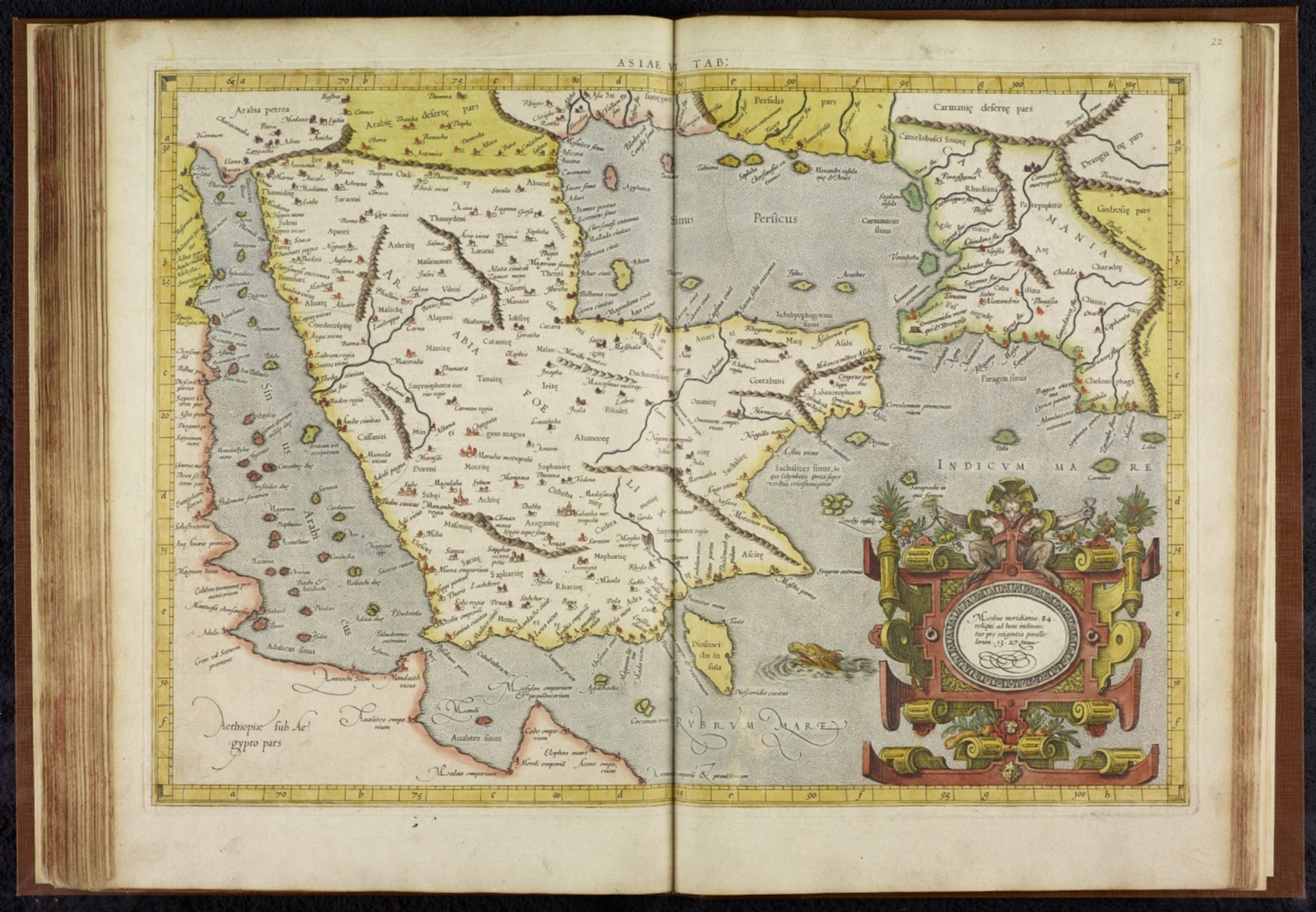
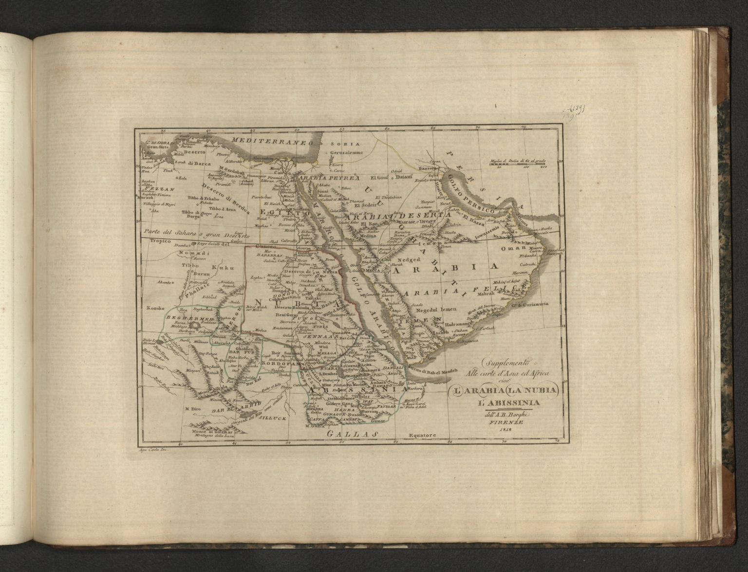
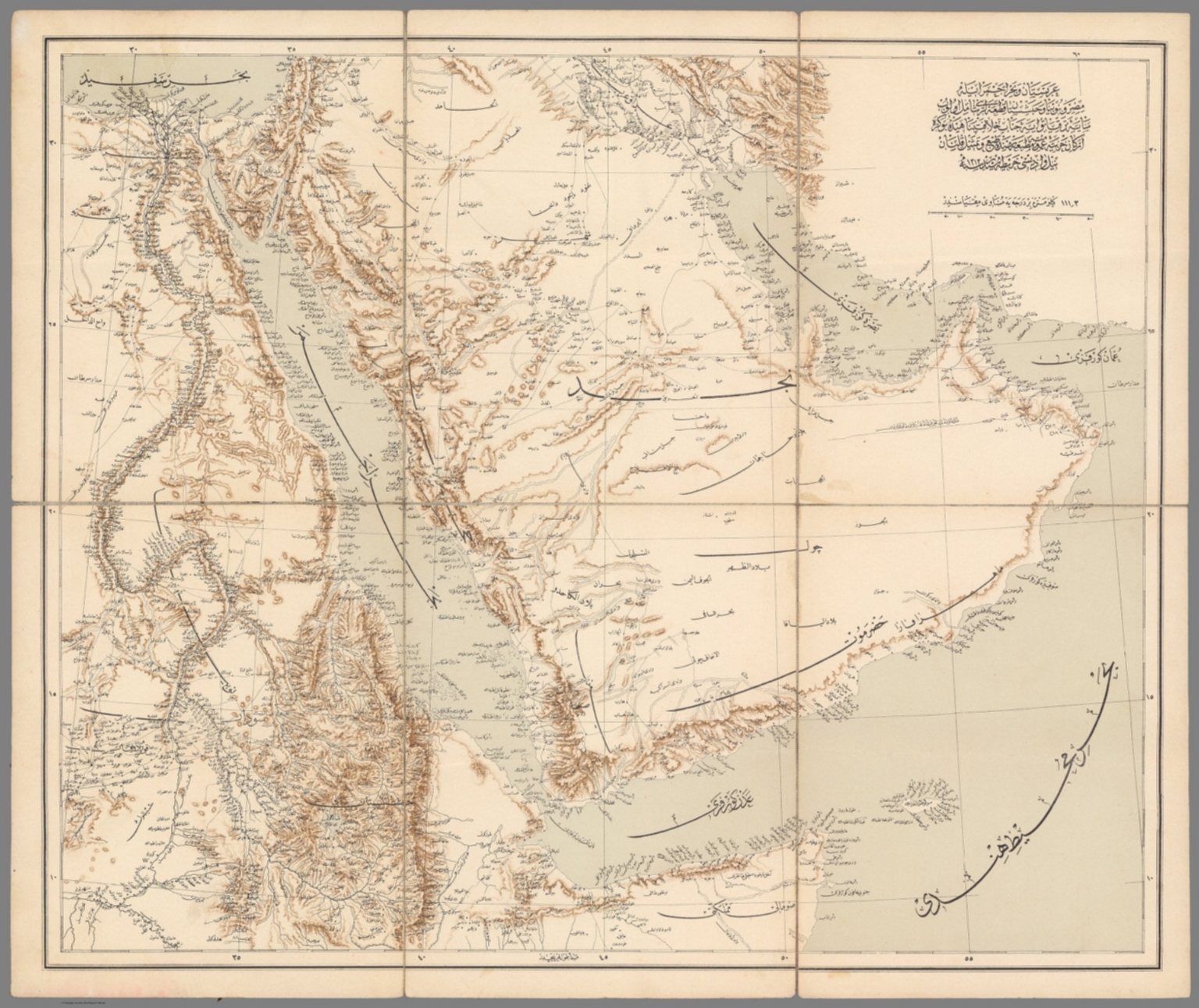
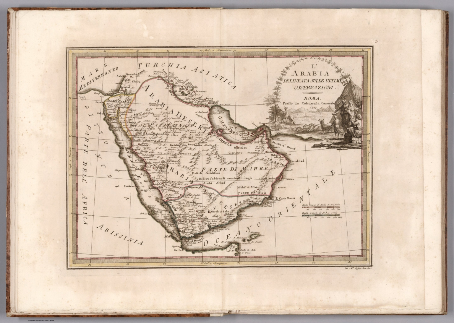
Arabian Peninsula and Red Sea region on sheet 53x64 dissected into 6 sections, backed with linen. Covers Egypt, Sudan and Somalia, Persian Gulf and Indian Ocean. Showing political divisions and kingdoms, ciliates, villages, roads, trails, river, lakes and mountains. Shows Nile River from the source to the mouth Relief shown by hachures., "This is one of the only large format Ottoman maps to focus on the Arabian Peninsula; indeed, it is the only one of which we are aware. It was issued in 1897 by the General Staff of the Ottoman Army during an especially dramatic period, when the Sublime Porte was going to great lengths to shore up its authority in the Red Sea region (Hejaz, Asir and Yemen), while being pressured by Britain to retreat from the domains it claimed in the Persian Gulf region (Kuwait, Al-Qatif/Hofuf and Qatar). Indeed, the present map would have been of great value to Ottoman generals and cabinet officials for strategic planning, as Arabia was increasingly a focus of global attention and interference. The map encompasses all of the Arabian Peninsula, and extends north as far as Haifa and Baghdad, and west to embrace Egypt, Sudan, and the Nile Valley, and runs south to Ethiopia and the Horn of Africa, while Persia appears in the upper right. The map has a very clean and precise appearance, making it easy to read and analyze, its design seemingly influenced by the German engineers who were then advising the Ottoman Army. The coastlines, rivers and swamplands are crisply depicted; mountain ranges are expressed by delicate tan shading; all cities and towns of note are labelled; the names of regions and tribal areas are noted; while all key roads and Hajj caravan routes are delineated. The map was predicated upon recent scientific mapping and is methodically empiricist in nature; all conjectural information is avoided. Sultan Abdul Hamid II (reigned 1876 - 1909) was obsessed with maintaining control of Hejaz and Islam’s holiest cities of Mecca and Medina, as the possession of these sites underpinned his claim to being the Caliph (Protector) of Islam. Mecca appears near the centre of the map, while the nearby port of Jeddah was home to the Red Sea command of the Ottoman Navy; while to the north is Medina. Much of the Syrian Hajj Road, perhaps the most frequented single overland route for pilgrims, is shown to run down to Mecca from the direction of Damascus. To the south of Hejaz is the region of Asir, and beyond northern Yemen, both areas to which the Ottomans had in recent years deployed massive military resources in an effort to subdue determined local unrest. Further still, is the British protectorate of Aden, home to a key Royal Navy Base, and up the coat, Oman, long a British protectorate. The map features stellar coverage of the Persian Gulf, labelling all the constituent sheikhdoms of the Trucial States, the future United Arab Emirates (Abu Dhabi, Dubai, Ras el Khaimah, etc.); Qatar (then an autonomous part of the Ottoman Empire); Bahrain (a British protectorate prized for its fine natural harbour); and Kuwait, an autonomous sheikhdom within the Ottoman Empire that would shortly become a British protectorate. Inland, the map details the Saudi-Wahhabi domains Nejd, with its capital Riyadh, while to the northwest is the territory of the rival Al-Rashid clan, with its capital Ha’il. Squeezed on both sides by Kuwait and Persia, the map shows that the Ottomans’ only remaining window to the Persian Gulf was the river port of Basra, on the Shatt al-Arab waterway, a major commercial centre and the regional headquarters of the Ottoman Army and Navy. Notably, extending from Najaf, Iraq, down to Mecca is one of the great Shia Hajj caravan routes. A Note on Rarity The present map was issued in only a very small print run for the exclusive use of the Ottoman military high command, as well as senor political figures; it was not to be sold or otherwise distributed. The map is extremely rare, we can locate only a single institutional example, held by the Türkiye Büyük Millet Meclisi Kütüphanesi (TBMM) [Library of Grand National Assembly], the Turkish parliamentary library in Ankara. Moreover, we are not aware of any other examples as having appeared on the market in recent times. The Anglo-Ottoman Contest for Control of Arabia The present map appeared at an especially tense time in the history of the Arabian Peninsula, when it was essentially a giant chessboard on which Britain and the Ottoman Empire were engaged in a complex contest for control, while the various local players struggled for autonomy. In essence, through the 19th Century, Britain, from her base in India, sought to gain ever more control over the Persian Gulf, while the Ottomans endeavored to shore up their powerbases in the Red Rea region (their efforts in the Gulf proved largely unsuccessful). Upon the end of the Napoleonic Wars, the Ottoman Empire’s authority on the Arabian Peninsula was on life support. The Sublime Porte was struggling to maintain control of Hejaz, home to Mecca and Medina, the holiest cities of Islam. Importantly, the Ottoman Sultan’s control of these sites was integral to his claim to being the Caliph (Protector) of Islam; the loss of the sites would completely undermine his legitimacy, especially in his Arab dominions. Beyond Hejaz, the Ottomans had long been evicted from Yemen and Asir. Turning to the Persian Gulf, the Sublime Porte claimed sovereignty over the coast from Kuwait, through the Al-Qatif-Hofuf region (now part of Saudi Arabia) to Qatar, as part of the Vilayet of Baghdad. However, their control beyond the great river port of Basra was weak, if not, in many places, nonexistent. Indeed, the Ottomans faced opposition from the Egyptians (former vassals who recently became de facto rivals), the Wahabis of the Nejd, Persia, as well as innumerable local sheikhs. Meanwhile, Britain, having consolidated its control of the Indian Subcontinent, was looking to expand it horizons towards the Persian Gulf. Britain, which had essentially made Oman a protectorate in 1800, signed the General Maritime Treaty of 1820 with Abu Dhabi, Ajman, Ras al Khaimah, Sharjah and Bahrain, that locked these sheikhdoms into the British defensive-economic system (Dubai would join the accord in 1835); these territories (with the exception of Bahrain) would become known as the ‘Trucial States’, the forerunner to the United Arab Emirates. In 1839, Britain established the port of Aden, in South Yemen, as a military base. During the Anglo-Persian War (1856-7), the British forced the weak Qajar Dynasty into staying out of their way, making the Gulf into something close to a ‘British Lake’. Meanwhile, the in 1840s, the Ottomans’ predicament the Red Sea improved somewhat. They managed to maintain absolutely secure control of Hejaz, and in 1849 mounted an invasion of North Yemen, that while unsuccessful on taking the highlands, managed to give the Sublime Porte a beachhead along the tihama, the coastal plain. The construction of the of the Suez Canal, which would be completed in 1869, was a transformative event, that shocked the Sublime Porte into drastic action. The canal, controlled by Anglo-French interests, would suddenly make the Red Sea into one of the world’s most important shipping lanes, posing a direct threat to Ottoman authority in the Arabian Peninsula. In 1869, the Ottomans sent a large army under their best field commander, Ahmed Muhtar, to conquer North Yemen and Asir. The difficult task of gaining the (recalcitrant) cooperation of the Zaidi Imams, who controlled the Yemen Highlands, was accomplished in 1872, giving the Sublime Porte control of Sana’a. Meanwhile, Midhat Pasha, the reforming Vali of Baghdad, sent armies to the Gulf, asserting Ottoman authority on the ground in Kuwait, Al-Qatif, Hofuf and Qatar for the first time in ages. The Ottomans henceforth maintained sizable permanent garrison of 600 men at Hofuf. At this point, it must be noted that Britain and the Ottoman Empire were not technically enemies but were rather engaged in an incredibly complex relationship. Britain was one the Sublime’s Porte largest trading partners, creditors, and often its military protector (notably during the Crimean War 1853-6). However, at the same time, Britain was happy to exploit the Ottomans’ weaknesses, taking from them whatever they could, while supporting them just enough so that the empire remained strong enough to survive. Britain expanded its presence in Yemen, essentially making all of the south of the country into the Aden Protectorate in 1872, while dramatically upgrading its naval bases in the region. Critically, Britain made Egypt a protectorate in 1882, essentially ending the Sublime Porte’s authority in the country (although Egypt technically remained part of the Ottoman Empire until 1914). The new Ottoman Sultan Abdul Hamid II (reigned 1876-1909) was a complex and clever man who tried to balance his desire to strengthen the Sublime Porte’s authority in Arabia (especially in the Red Sea) with his fear of provoking Britain. Unlike some of his predecessors were not religiously inclined, Abdul Hamid II passionately valued his role as Caliph of Islam; maintaining control over Hejaz was his overriding imperative. In 1887, the Ottomans established a large permanent naval base at Jeddah and continued to send sizeable expeditions into the highlands of Asir and Yemen. This succeeded in causing the Zaidis in Sana’a to stand down from a planned revolt in 1891, although the Ottomans’ control of Yemen and Asir beyond their garrisons was very limited. As such, most of the time their forces were engaged in moving around the country simply ‘putting out fires’, as opposed to locking down control of the territory. To anchor Ottoman authority in the Red Sea, Abdul Hamd II authorized the construction of the Hejaz Railway, which was to run from Damascus to Mecca. Construction commenced in in 1900, and the line reached Medina by 1908, where progress was halted. While never completed to Mecca, the railway played vital role in giving the Ottomans a fighting chance to hold on to Hejaz, Asir and North Yemen. While Ottoman authority in the Red Sea was stable, its prospects in the Gulf were deteriorating. It must be noted at this point that a bit of local power vacuum had developed, as the interior of what is today Saudi Arabia was locked in struggle between the rival Saudi and Al Rashid clans. In 1891, the Al Rashids, based in Ha’il, had dislodged the Saudis from their capital Riyadh, and the conflict was ongoing; it would not be until 1906 that the Saudis would regain the upper hand. In 1892, Britain locked down its political-economic suzerainty over the Trucial States and Oman into “exclusive agreements” (Bahrain signed a similar accord in 1880), essentially banning these states from having anything to do with any other entity unless sanctioned by Britain. Meanwhile, the Al Thani clan which ruled Qatar revolted and defeated the Ottomans at the Battle of Al Wajbah (1893), essentially making Qatar autonomous of the Sublime Porte. Shortly after the present map was issued, Britain signed the Anglo-Kuwaiti Agreement of 1899, which made the sheikhdom a British protectorate, even if it was still technically a part of the Ottoman Empire. Essentially, the by the end of the 19th century, the Ottoman presence in the Gulf was limed to the small window provided by Basra and the Shatt al-Arab waterway. At the dawn of the new century, Britain’s interest in the Gulf heightened as it began to search for commercially exploitable petroleum deposits in order to fuel its industrial economy and to provide a new, improved power source for the Royal Navy (big oil would be struck in southwestern Persia in 1908). Meanwhile, the Sultan Abdul Hamid II, seeking to counter British influence, solidified his alliance with Germany, which was quickly rising to become Britain’s main geostrategic rival. In 1903, the German interests commenced the building of the Baghdad Railway, from Istanbul to the Iraqi capital, that was proposed to one day be extended to provide a rail link from Berlin to Basra. If ever completed, the Baghdad Railway would pose a grave threat to British interests in the Gulf. Returning to the Red Sea, in 1904, the new Zaidi leader, Imam Yahya, mounted a full-scale rebellion against Ottoman rule. A highly intelligent and disciplined guerrilla commander, his tactics outmatched the Sultan’s overstretched forces and the Ottomans were virtually driven out of the Yemeni highlands. After years of hard fighting that wore down both parties, the Imam and the Sublime Porte signed the Treaty of Da’an (1911), which settled matters largely on Zaidi terms; essentially the Zaidis would rule North Yemen, with only very light Ottoman oversight. Meanwhile, the Ottomans were also having trouble in Asir, as beginning in 1906 the local leader Muhammad ibn Ali al-Idrisi rebelled against the Sublime Porte. The Idrisids succeeding in driving the Ottomans out of much of Asir and Jizan by 1910, forming the Idrisid Emirate of Asir. In an effort to deescalate tensions in the Gulf, in the Sublime Porte and Britain signed the Anglo- Ottoman Convention of 1913, by which the Ottomans essentially agreed not to attempt to occupy Kuwait and the other Gulf sheikhdoms they claimed, in exchange for Britain acknowledging the Sublime Porte’s de jure sovereignty over these areas. As is well known, the Ottoman presence on the Arabian Peninsula was brought to an end during World War I. The British mounted the Mesopotamian Campaign, taking Basra in November 1914, completely removing the Ottomans from the Gulf forever. On the other side of the peninsula, the Sharif of Mecca formed an alliance with Britain, flamboyantly represented by Lawrence of Arabia, resulting Arab Revolt (1916-8), which eventually succeeded in running the Ottomans out of the region (only the Ottoman garrison at Medina held out for the duration of the war). Further south, the Ottomans joined forces with the Zaidis against Britain, for a time putting up very strong resistance; however, the Sublime Porte’s efforts in the region were all for naught upon the war’s end.. (Alexander Johnson and Dasa Pahor, 2020), Türkiye Büyük Millet Meclisi Kütüphanesi (TBMM) [Library of Grand National Assembly], Ankara: 201102358.