893 results
Search Results
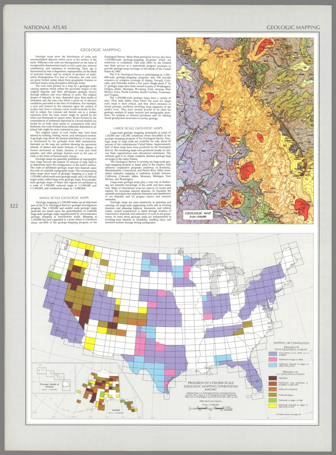
2. Geologic map : Scale 1:250,000 -- Progress of 1:250,000-scale geologic mapping operations, June 1967 / adapted from U. S. Geological Survey, Geological Survey research, 1967, chap. A, U. S. Geological Survey Professional Paper 575-A, Washington, U. S. Govt. Print. Off., 1967, p. A63.
3. A Map of Air Mail & Passenger Routes. Prepared by Byron Weston Company, Manufacturers of Highest Grade Record and Ledger Papers. Dalton, Massachusetts and Printed on Weston's Linen Ledger. (c) B.W. Co. 1930.
4. (Facsimile) Map of Western Part of the Dominion of Canada (portion) to Accompany a Paper by Wm. Ogilvie. Scottish Geographical Magazine, 1898. The Edinburgh Geographical Institute. J.G. Bartholomew. Alaskan Boundary Tribunal, 1903. 46. Andrew B. Graham. Photo-Litho. Washington.D.C.
5. (Facsimile) Papers _ Hudsons Bay Company. Map of North America. Photo. Lith. by A. Hoen & Co. Baltimore, MD. No. 542. Ordered by the House of Commons to be Printed 12th. July 1850. Henry Hansard, Printer.
6. Value of products of manufactures per square mile: 1900. 1. Petroleum refining. 2. Chemicals and allied products. 3. Paper and wood pulp. 4. Printing and publishing. 5. Leather, tanned, curried and finished. 6. Boots and shoes, factory products. (Prepared under the supervision of Henry Gannett, Geographer of the Twelfth Census. United States Census Office, 1903). Julius Bien & Co., N.Y.
7. Value of products of selected industries: 1900. 1. Chemicals and allied products. 2. Petroleum refining. 3. Paper and wood pulp. 4. Printing and publishing, book and job, music and newspapers. (Prepared under the supervision of Henry Gannett, Geographer of the Twelfth Census. United States Census Office, 1903). Julius Bien & Co., N.Y.
8. Manufactures: 1890. Value of product in dollars per head of population. 343. Cotton. 344. Lumber. 345. Glass. 346. Hosiery and knit goods. 347. Leather. 348. Paper. Julius Bien & Co. Lith., N.Y. (1898)
9. A Map of the United States at the Close of the Revolutionary War. 1492-1783. The first in a series of four maps showing the territorial expansion of the United States and notes of historical events of the era. Karl Smith. Lindweave hisotrical map. Copyright 1957 by 'Linweave', Springfield, Mass. This map is lithographed on Linweave early American, white , 80 Lb. Basis. (to accompany) Growth and development of America in maps by Linweave.
10. A Map of the United States Showing Boundaries Established after the Louisiana Purchase and Florida Acquisition.1784-1844. The second in a series of four maps showing the territorial expansion of the Country, with historical notes covering the period from the Revolutionary War to the Annexation of Texas. Karl Smith. Lindweave hisotrical map. Copyright 1958 by 'Linweave', Springfield, Mass. (to accompany) Growth and development of America in maps by Linweave.
11. A Map of the United States Showing Boundaries at the Close of the Civil War. 1845-1866. The third in a series of four maps showing the territorial expansion of the Country, with historical notes covering the period from the Annexation of Texas to the close of the Civil War. Karl Smith. Lindweave hisotrical map. Copyright 1959 by 'Linweave', Springfield, Mass. (to accompany) Growth and development of America in maps by Linweave.
12. A map of the United States and possessions, including Alaska and Hawaii, 1867-1960 : the fourth of a series of four maps showing the territorial expansion of the country, with historical notes covering the period from the close of the Civil War to the admission of Hawaii. Karl Smith. Lindweave hisotrical map. Copyright 1959 by 'Linweave', Springfield, Mass. (to accompany) Growth and development of America in maps by Linweave.
13. A Map of the United States, of America; by H.S. Tanner.
14. Map of the United States of America. Gridley Sc.
15. Carte Generale des Etats - Unis et du Mexique : Comprenant L'Amerique Centrale Et Les Antilles. E. Andriveau-Goujon, Editeur. Paris, Rue Du Bac, 21. 1862. (to accompany) Atlas classique et universel de geograparphie ancienne et moderne ... Nouvelle edition. 1863.
16. Carte Generale des Etats - Unis et du Mexique : Comprenant L'Amerique Centrale Et Les Antilles. E. Andriveau-Goujon, Editeur. Paris, Rue Du Bac, 21. 1862. (to accompany) Atlas classique et universel de geograparphie ancienne et moderne ... Nouvelle edition. 1863.
17. (Composite Map) Carte Generale des Etats - Unis et du Mexique : Comprenant L'Amerique Centrale Et Les Antilles. E. Andriveau-Goujon, Editeur. Paris, Rue Du Bac, 21. 1862. (to accompany) Atlas classique et universel de geograparphie ancienne et moderne ... Nouvelle edition. 1863.
18. Box2_33 plate
19. Box2_19 plate
20. (Covers to) Seeing the U.S.A. with Mr. Peanut : A story book trip through the 48 states, Alaska, Hawaii and Puerto Rico / presented by the makers of Planters Peanuts, Planters Nuts & Chocolate Co., Suffolk, Va. Wilkes-Barre, Pa. San Francisco, Cal. This book created by Joseph R. Fisher. Printed in U.S.A.
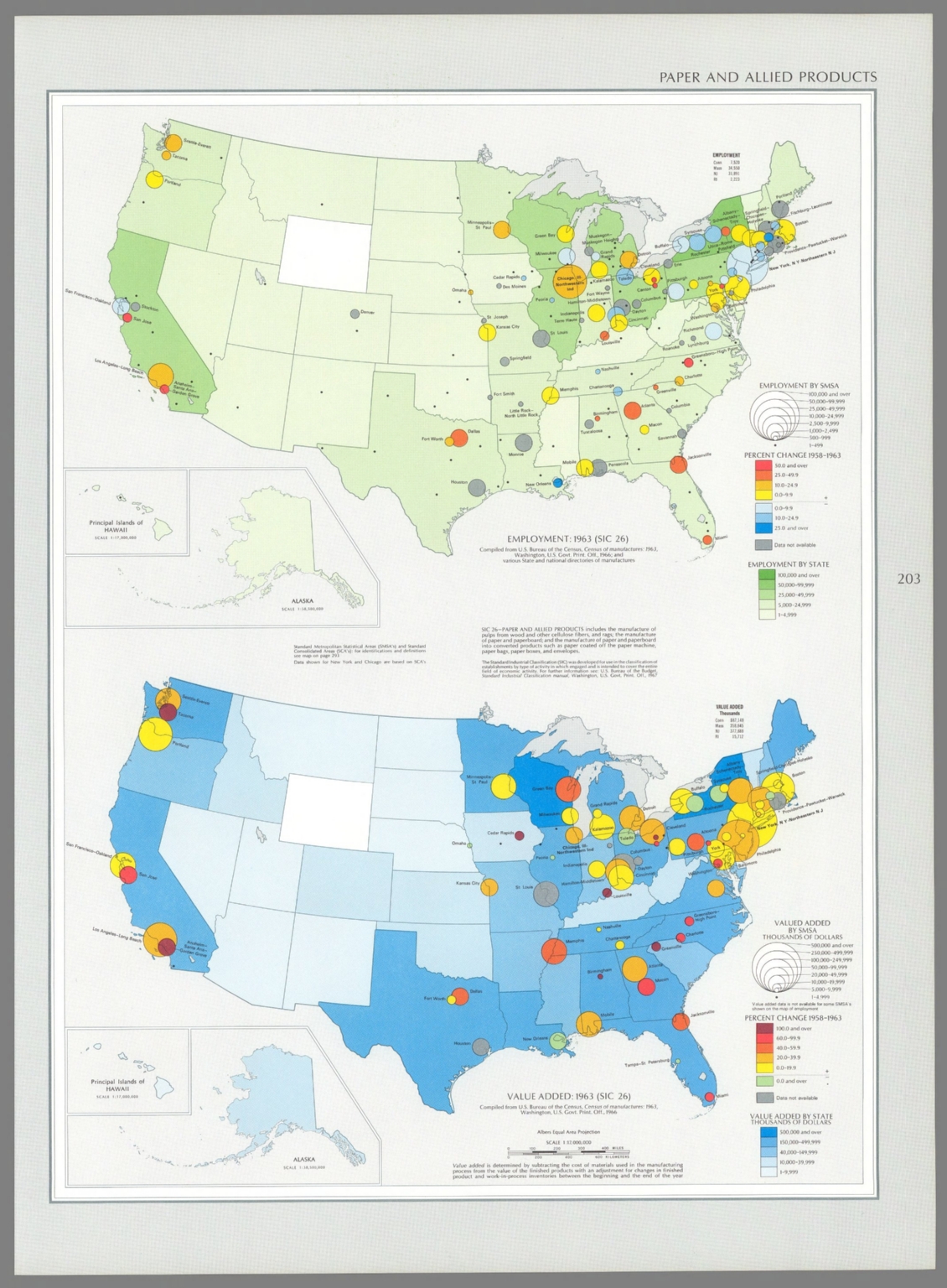
21. Employment : 1963 (SIC 26) / compiled from U. S. Bureau of the Census, Census of manufacturers: 1963, Washington, U. S. Govt. Print Off., 1966; and various State and national directories of manufacturers -- Value added : 1963 (SIC 26) / compiled from U. S. Bureau of the Census, Census of manufacturers: 1963, Washington, U. S. Govt. Print Off., 1966.
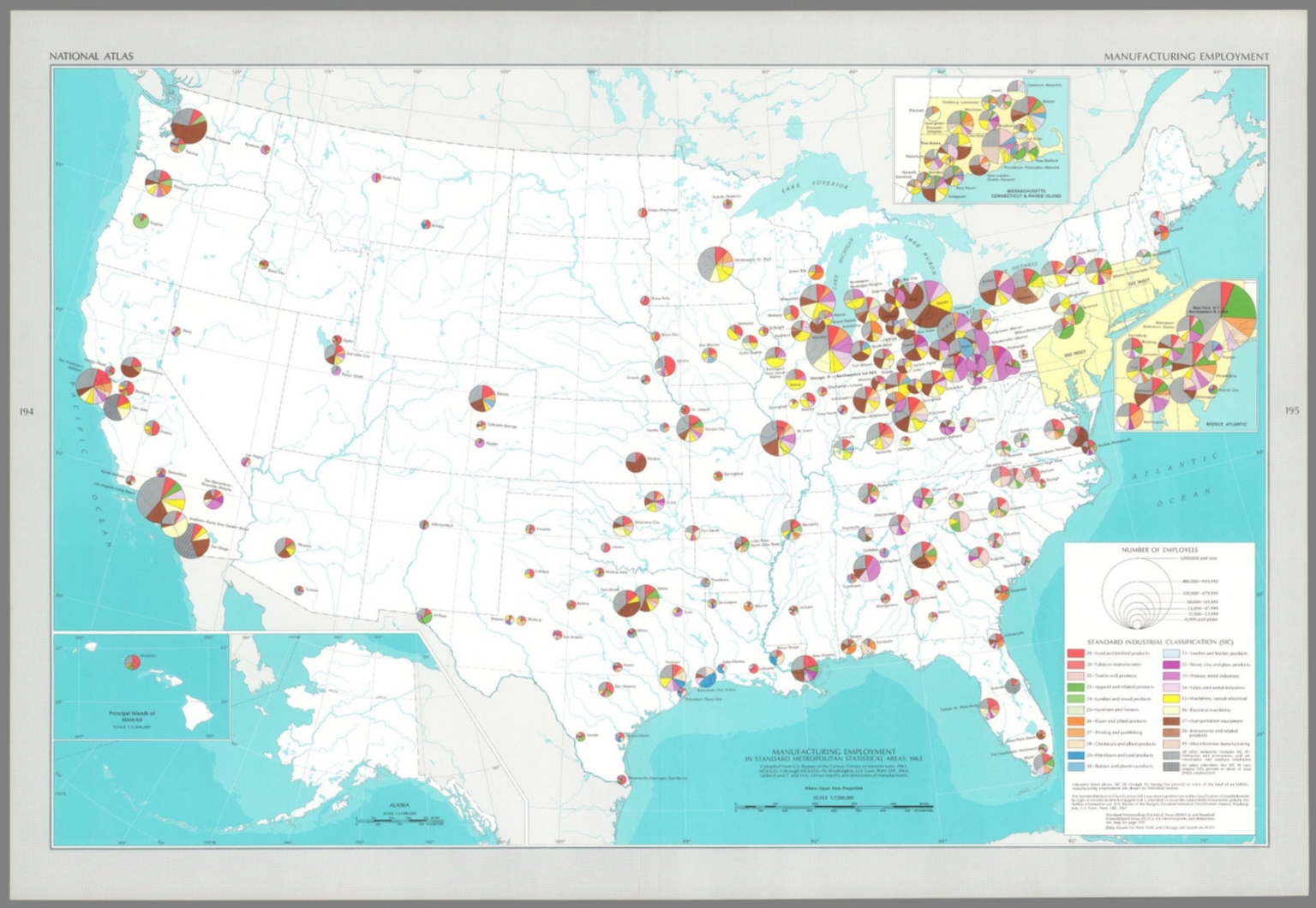
22. Manufacturing employment in standard metropolitan statistical areas : 1963 / compiled from U. S. Bureau of the Census, Census of manufacturers: 1963, MC63(3)-1 through MC63(3)-51, Washington, U. S. Govt. Print Off., 1964, tables 6 and 7, and misc. census reports and directories of manufacturers.
23. United States. Drawn by A. Arrowsmith. Engraved by Thomson & Hall. Published, 1817, by A. Constable & Co. Edinburgh.
24. Map Of The United States The British Provinces Mexico &c. Showing the Routes of the U.S. Mail Steam Packets to California, and a Plan of the Gold Region. Published By J.H. Colton, 86 Cedar St. New York. 1849. Drawn & Engraved by J.M. Atwood. New York. Entered ... 1849, by J.H. Colton ... New York. (inset) Map Of The Gold Region. California. (untitled inset of South America; From New York to San Francisco via Cape Horn...).
25. Amerique Boreale, Nouvle. Bretagne & Canada. Atlas spheroidal & universel de geographie dresse par F.A. Garnier, geographe. Ve. Jules Renouard, Editeur, Rue de Tournon, no. 6, Paris. 1860. Impie. de Louis Antoine, 1, Rue de Cluny, Paris.
26. Etats-Unis de l'Amerique du Nord. Limites en 1860. (with) Iles St. Pierre et Miquelon. Atlas spheroidal & universel de geographie dresse par F.A. Garnier, geographe. Ve. Jules Renouard, Editeur, Rue de Tournon, no. 6, Paris. 1860. Imp. Louis Antoine, r. de Cluny, 1, Paris.
27. Etats-Unis de l'Amerique du Nord. Limites en 1855. (with) Iles St. Pierre et Miquelon. (with) Partie sud du Territoire de la Floride. Atlas spheroidal & universel de geographie dresse par F.A. Garnier, geographe. Ve. Jules Renouard, Editeur, Rue de Tournon, no. 6, Paris. 1860. Imp. Sarazin, R. Git-le-Coeur, 8, Paris.
28. The United States. Published by Cummings & Hilliard, No. 1, Cornhill, Boston. W. B. Annin, sc. (to accompany) An Ancient And Modern Atlas, Containing Thirteen Ancient And Eight Modern Maps.
29. United States. Neele sculp. Published Jany. 1st. 1819, by Pinnock & Maunder Strand.
30. (Index Page to) List Of Post Towns. (to accompany) A New Juvenile Atlas, And Familiar Introduction To The Use Of Maps: With A Comprehensive View Of The Present State Of The Earth ... First American From The Latest London Edition, Corrected And Improved, By John Melish. Philadelphia, Printed For John Melish, John Vallance, And H.S. Tanner, No. 209, Chestnut-Street, By G. Palmer. 1814.
31. (Index Page to) List Of Post Towns. (to accompany) A New Juvenile Atlas, And Familiar Introduction To The Use Of Maps: With A Comprehensive View Of The Present State Of The Earth ... First American From The Latest London Edition, Corrected And Improved, By John Melish. Philadelphia, Printed For John Melish, John Vallance, And H.S. Tanner, No. 209, Chestnut-Street, By G. Palmer. 1814.
32. (Index Page to) List Of Post Towns. (to accompany) A New Juvenile Atlas, And Familiar Introduction To The Use Of Maps: With A Comprehensive View Of The Present State Of The Earth ... First American From The Latest London Edition, Corrected And Improved, By John Melish. Philadelphia, Printed For John Melish, John Vallance, And H.S. Tanner, No. 209, Chestnut-Street, By G. Palmer. 1814.
33. (Index Page to) List Of Post Offices. (to accompany) A New Juvenile Atlas, And Familiar Introduction To The Use Of Maps: With A Comprehensive View Of The Present State Of The Earth ... First American From The Latest London Edition, Corrected And Improved, By John Melish. Philadelphia, Printed For John Melish, John Vallance, And H.S. Tanner, No. 209, Chestnut-Street, By G. Palmer. 1814.
34. (Index Page to) List Of Post Towns. (to accompany) A New Juvenile Atlas, And Familiar Introduction To The Use Of Maps: With A Comprehensive View Of The Present State Of The Earth ... First American From The Latest London Edition, Corrected And Improved, By John Melish. Philadelphia, Printed For John Melish, John Vallance, And H.S. Tanner, No. 209, Chestnut-Street, By G. Palmer. 1814.
35. (Index Page to) List Of Post Towns. (to accompany) A New Juvenile Atlas, And Familiar Introduction To The Use Of Maps: With A Comprehensive View Of The Present State Of The Earth ... First American From The Latest London Edition, Corrected And Improved, By John Melish. Philadelphia, Printed For John Melish, John Vallance, And H.S. Tanner, No. 209, Chestnut-Street, By G. Palmer. 1814.
36. (Index Page to) Table Of The Principal Places In The United States, With Their Latitudes and Longitudes From Washington. 'Those in Capitals are Seats of Government.' (and) Table Of The Post Towns In The United States, With their Distances from Washington. (to accompany) A New Juvenile Atlas, And Familiar Introduction To The Use Of Maps: With A Comprehensive View Of The Present State Of The Earth ... First American From The Latest London Edition, Corrected And Improved, By John Melish. Philadelphia, Printed For John Melish, John Vallance, And H.S. Tanner, No. 209, Chestnut-Street, By G. Palmer. 1814.
37. (Text Pageto) Of England And Wales. (to accompany) A New Juvenile Atlas, And Familiar Introduction To The Use Of Maps: With A Comprehensive View Of The Present State Of The Earth ... First American From The Latest London Edition, Corrected And Improved, By John Melish. Philadelphia, Printed For John Melish, John Vallance, And H.S. Tanner, No. 209, Chestnut-Street, By G. Palmer. 1814.
38. (Text Pageto) Of The United States (and) Of England And Wales. (to accompany) A New Juvenile Atlas, And Familiar Introduction To The Use Of Maps: With A Comprehensive View Of The Present State Of The Earth ... First American From The Latest London Edition, Corrected And Improved, By John Melish. Philadelphia, Printed For John Melish, John Vallance, And H.S. Tanner, No. 209, Chestnut-Street, By G. Palmer. 1814.
39. United States. (engraved by) H.S. Tanner. Sc. Published ... 1814 by J. Melish. J. Vallance & H.S. Tanner. Philadelphia. Includes References to the States. &c. (to accompany) A New Juvenile Atlas, And Familiar Introduction To The Use Of Maps: With A Comprehensive View Of The Present State Of The Earth ... First American From The Latest London Edition, Corrected And Improved, By John Melish. Philadelphia, Printed For John Melish, John Vallance, And H.S. Tanner, No. 209, Chestnut-Street, By G. Palmer. 1814.
40. (Title Page to) Leahy's Hotel Guide and Railway Distance Maps of America. The Green book, It Shows the Way. Published by American Hotel Register Company. Leahy Building 228-234 W. Ontario street, Chicago, Ill. Established Nearly Half Century. Revised Edition No. 59, Copyrighted Jan. 1934. Price of this book, complete $5.00. Subscription, Five Years .... $20.00, Combined Guide and Map of any Individual State 25 cents.
41. (Covers to) A New American Atlas, Designed Principally To Illustrate The Geography Of The United States Of North America; In Which Every Country In Each State And Territory Of The Union Is Accurately Delineated, As Far As At Present Known: The Whole Compiled From The Latest And Most Authentic Information. Philadelphia: Published By Anthony Finley, At The North-East Corner Of Chestnut And Fourth Streets. 1826.
42. (Title Page to) A Complete Historical, Chronological, And Geographical American Atlas, Being A Guide To The History Of North And South America, And The West Indies ... To The Year 1822. According To The Plan Of Le Sage's Atlas And Intended As A Companion To Lavoisne's Improvement Of That Celebrated Work. Philadelphia: H.C. Carey And I. Lea, Chestnut Street. 1822. (on verso) ... T.H. Palmer, Printer.
43. Map Of The United States By J.H. Young. Published by S. Augustus Mitchell. Entered ... Pennsylvania, October 10th, 1831 by S. Augustus Mitchell. Engraved by J.H. Young, D. Haines & F. Dankworth. (inset) A Map Of North America Including All The Recent Geographical Discoveries. (with 10 additional inset maps).
44. (Covers to) Map Of The United States By J.H. Young. Published by S. Augustus Mitchell. Entered ... Pennsylvania, October 10th, 1831 by S. Augustus Mitchell. Engraved by J.H. Young, D. Haines & F. Dankworth. (inset) A Map Of North America Including All The Recent Geographical Discoveries. (with 10 additional inset maps).
45. (United States of North America) Die staaten von N. & S. Carolina, Georgia & Florida 1853. Aus der Geograph. Graviranstalt des Bibliograph. Instituts. (In upper margin) Meyer's Groschen Atlas. (to accompany: Meyer's Zeitungs und Groschen Atlas aller Lander und Staaten der Erde). (insets) Hafen von St. Augustine. (with) Gold-Region von Nord-Carolina. (with) Newberne. (with) Charleston.
46. Die staaten Maine, New Hampshire, Massachusetts, Vermont, Connecticut & Rhode I. 1853. (United States of North America). Stahlstich (Direction v. Kleinknecht). (In upper margin) Meyer's Zeitungs Atlas. No. 69. (to accompany: Meyer's Zeitungs und Groschen Atlas aller Lander und Staaten der Erde). (insets) Boston. (with) New Haven. (with) Hartford.
47. Die staaten Arkansas, Mississippi, Louisiana & Alabama.1853. (United States of North America). Stahlstich, Druck und Verlag der Geographischen des Bibliographischen Instituts. (In upper margin) Meyer's Zeitungs Atlas. No. 67. (to accompany: Meyer's Zeitungs und Groschen Atlas aller Lander und Staaten der Erde). (inset) New Orleans.
48. Vereinigte Staaten von Nord-America und Mexico. 1852. Entw. u. gez. v. Major Radefeld. Stahlstich (Direction v. Kleinknecht). (In upper margin) Meyer's Groschens Atlas. (to accompany: Meyer's Zeitungs und Groschen Atlas aller Lander und Staaten der Erde). (with 6 insets).
49. Die Staaten von Missouri Illinois, Indiana, Ohio, Kentucky & Tennessee. 1852. United States o f North-America. Stahlstich (Direction v. Kleinknecht). (In upper margin) Meyer's Groschens Atlas. (to accompany: Meyer's Zeitungs und Groschen Atlas aller Lander und Staaten der Erde). (insets) Cincinnati. (with) Nashville. (with) Lexington.
50. Vereinigte Staaten von Nord-America : Californien, Texas und die Territorien New Mexico u. Utah. Nach den neuesten Hülfsmitteln gezeich von J. Grassl. 1852. (In upper margin) Meyer's Zeitungs Atlas. No. 120. (to accompany: Meyer's Zeitungs und Groschen Atlas aller Lander und Staaten der Erde).
Discovery Service for Jio Institute Digital Library
For full access to our library's resources, please sign in.


