25,385 results
Search Results

2. Ta-Non-Ka's Indians of the paper country. Badger Paper Mills, Peshtigo, Wisconsin. Maker of Ta-Non-Ka Mimo Bond. copyright 1942. Printed on Ta-Non-Ka substance 24.

3. (Text Page to) Growth and development of America in maps by Linweave. A demonstration of Linweave Paper and an Historical and decorative memento for you. Lithographed on Linweave Capri ... Printed in U.S.A. DR-1259-4.5.

4. (63) Pulp and paper mills : (Pulp and paper mills in Western Canada) -- (Pulp and paper mills in Eastern Canada). Compiled from information supplied by the Forestry Branch, Department of Northern Affairs and National Resources. (Canada Department of Mines and Technical Surveys.)
5. (Text Page to) (63) Pulp and paper mills : (Pulp and paper mills in Western Canada) -- (Pulp and paper mills in Eastern Canada). Compiled from information supplied by the Forestry Branch, Department of Northern Affairs and National Resources. (Canada Department of Mines and Technical Surveys.)
6. (Covers to) Atlas geog. (End papers)

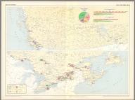
7. The drift of bottle papers in the North Atlantic. Supplement to the Pilot chart of the North Atlantic Ocean, July, 1891. Division of Marine Meteorology, H. M. Witzel, Lieut. U.S.N. Marine Meteorologist, Everett Hayden. Published monthly at the Hydrographic Office, Navy Department, Washington, D.C. Richardson Clover, Lieut. Comdr., U.S.N., Hydrographer.

8. (Text Page to) Notice of the different processes adopted at the Ordnance Map Office Southampton in the publication of the maps and plans. (to accompany) Report on the Ordnance Survey of the United Kingdom for 1855-56. (with) Ordnance Survey. Treasury minute, dated 18 May 1855, and previous papers, relating to the Ordnance Survey. Session 1856.

9. (Text Page to) Ordnance Survey. Treasury minute, dated 18 May 1855, and previous papers, relating to the Ordnance Survey. (Presented to Parliament by Her Majesty's Command.) Session 1856. (with) Report on the Ordnance Survey of the United Kingdom for 1855-56. (Signed) Henry James, Lieutenant-Colonel Royal Engineers.

10. (Composite map) Geologic map of North America. Compiled by the United States Geological Survey in cooperation with the Geological Survey of Canada and Instituto Geologico de Mexico ; under the supervision of Bailey Willis and George W. Stose. 1911. Geologic drafting by Henry S. Selden. Engraved and printed by the U.S. Geological Survey. (insets) Aleutian Islands. (with) Windward Islands. (at the margin) Professional paper 71. U.S. Geological Survey, George Otis Smith, Director.

11. (View) White Water Paper Mills, Stewart Paper Company, Brookville, Franklin County, Ind.

12. (Text Page to) On the mode of communication of cholera. By John Snow. Second edition, much enlarged. London: London, J. Churchill, M.DCCC.LV. (1855). (to accompany) Snow on Cholera : being a reprint of two papers, by John Snow; together with a biographical memoir by B.W. Richardson ; and an introduction by Wade Hampton Frost. New York : Commonwealth Fund. London : Humphrey Milford: Oxford University Press 1936.

13. (Title Page to) Snow on Cholera : being a reprint of two papers, by John Snow ; together with a biographical memoir by B.W. Richardson ; and an introduction by Wade Hampton Frost. New York : Commonwealth Fund. London : Humphrey Milford: Oxford University Press 1936.

14. (Portrait) John Snow. (to accompany) Snow on Cholera : being a reprint of two papers, by John Snow ; together with a biographical memoir by B.W. Richardson ; and an introduction by Wade Hampton Frost. New York : Commonwealth Fund. London : Humphrey Milford: Oxford University Press 1936.

15. Wigtonshire : Specimen with hills engraved. Sheet 3. (to accompany) Report on the Ordnance Survey of the United Kingdom for 1855-56. (with) Ordnance Survey. Treasury minute, dated 18 May 1855, and previous papers, relating to the Ordnance Survey. Session 1856.

16. Letters: Various letters by and to Henry James, associated with the book. (to accompany) Report on the Ordnance Survey of the United Kingdom for 1855-56. (with) Ordnance Survey. Treasury minute, dated 18 May 1855, and previous papers, relating to the Ordnance Survey. Session 1856.

17. Text Composite: On A Necessary Correction of the Observed Height of the Barometer. (to accompany) Report on the Ordnance Survey of the United Kingdom for 1855-56. (with) Ordnance Survey. Treasury minute, dated 18 May 1855, and previous papers, relating to the Ordnance Survey. Session 1856.

18. Co. Donegal : Specimen with hills engraved. Sheet 2. N.E. (to accompany) Report on the Ordnance Survey of the United Kingdom for 1855-56. (with) Ordnance Survey. Treasury minute, dated 18 May 1855, and previous papers, relating to the Ordnance Survey. Session 1856.

19. (Text Page to) (Continued) Specimen (of text) reproduced by the Anastatic Process from Letterpress.(to accompany) Report on the Ordnance Survey of the United Kingdom for 1855-56. (with) Ordnance Survey. Treasury minute, dated 18 May 1855, and previous papers, relating to the Ordnance Survey. Session 1856.

20. Co. Wicklow : Ornament engraved. Sheet 40. (with) Fifeshire : Ornament punched. Sheet 30. (to accompany) Report on the Ordnance Survey of the United Kingdom for 1855-56. (with) Ordnance Survey. Treasury minute, dated 18 May 1855, and previous papers, relating to the Ordnance Survey. Session 1856.

21. Lewis (Ross Shire) : Specimen in outline. Sheet 4. (to accompany) Report on the Ordnance Survey of the United Kingdom for 1855-56. (with) Ordnance Survey. Treasury minute, dated 18 May 1855, and previous papers, relating to the Ordnance Survey. Session 1856.

22. Edinburghshire : Specimen in outline. Sheet 32. (with) Co. Dublin : Specimen in outline. Sheet 31. S.E. (to accompany) Report on the Ordnance Survey of the United Kingdom for 1855-56. (with) Ordnance Survey. Treasury minute, dated 18 May 1855, and previous papers, relating to the Ordnance Survey. Session 1856.

23. Yorkshire : Specimen with hills engraved. Sheet 95 S.W. (to accompany) Report on the Ordnance Survey of the United Kingdom for 1855-56. (with) Ordnance Survey. Treasury minute, dated 18 May 1855, and previous papers, relating to the Ordnance Survey. Session 1856.

24. Specimen by the Anastatic process transferred from a tracing. (with) Specimen by the Anastatic process, from plate, reproduced from an Anastatic impression. (to accompany) Report on the Ordnance Survey of the United Kingdom for 1855-56. (with) Ordnance Survey. Treasury minute, dated 18 May 1855, and previous papers, relating to the Ordnance Survey. Session 1856.

25. Specimen by the Anastatic process, transferred from a tracing. (to accompany) Report on the Ordnance Survey of the United Kingdom for 1855-56. (with) Ordnance Survey. Treasury minute, dated 18 May 1855, and previous papers, relating to the Ordnance Survey. Session 1856.

26. Specimen by Lithography, transferred from a tracing. (with) Specimen reproduced by the Anastatic process, from a Lithograph. (to accompany) Report on the Ordnance Survey of the United Kingdom for 1855-56. (with) Ordnance Survey. Treasury minute, dated 18 May 1855, and previous papers, relating to the Ordnance Survey. Session 1856.

27. Edinburghshire : From the original plate. (with) Edinburghshire : From an electrotype. Sheet 2. Scale six inches to a mile. (to accompany) Report on the Ordnance Survey of the United Kingdom for 1855-56. (with) Ordnance Survey. Treasury minute, dated 18 May 1855, and previous papers, relating to the Ordnance Survey. Session 1856.

28. Specimen by Zinography, transferred from a tracing. (with) Specimen reproduced by the Anastatic process, from a Zinograph. (to accompany) Report on the Ordnance Survey of the United Kingdom for 1855-56. (with) Ordnance Survey. Treasury minute, dated 18 May 1855, and previous papers, relating to the Ordnance Survey. Session 1856.

29. Hill sketching reduced from six inch to one inch to a mile by photography for the engraver. (to accompany) Report on the Ordnance Survey of the United Kingdom for 1855-56. (with) Ordnance Survey. Treasury minute, dated 18 May 1855, and previous papers, relating to the Ordnance Survey. Session 1856.

30. (Text Page to) Specimen (of text) reproduced by the Anastatic Process from Letterpress.(to accompany) Report on the Ordnance Survey of the United Kingdom for 1855-56. (with) Ordnance Survey. Treasury minute, dated 18 May 1855, and previous papers, relating to the Ordnance Survey. Session 1856.

31. A specimen of part of a 1/500 plan ; colored for reduction by photography. South Shields, sheet 36. (to accompany) Report on the Ordnance Survey of the United Kingdom for 1855-56. (with) Ordnance Survey. Treasury minute, dated 18 May 1855, and previous papers, relating to the Ordnance Survey. Session 1856.

32. Part of the Parish of Darlington. Co. Durham. Reduced from 1/2,500 of 25, 34-4 inches to 6 inches to a mile by photography. (to accompany) Report on the Ordnance Survey of the United Kingdom for 1855-56. (with) Ordnance Survey. Treasury minute, dated 18 May 1855, and previous papers, relating to the Ordnance Survey. Session 1856.
33. Geometrical projection of two third of the sphere by Lieut. Colonel H. James, R.E., F.R.S. M.R.I.A. &c. ... Engraved at the Ordnance Survey Map Office Southampton, 1857 from a reduction made by photography. (insets) Projection of Central Station ; Projection of Central Meridian Station. (to accompany) Report on the Ordnance Survey of the United Kingdom for 1855-56. (with) Ordnance Survey. Treasury minute, dated 18 May 1855, and previous papers, relating to the Ordnance Survey. Session 1856.

34. Specimen of part of a 6 inch sheet. Hills sketched for reduction ay photography. Yorkshire. sheet 47. (to accompany) Report on the Ordnance Survey of the United Kingdom for 1855-56. (with) Ordnance Survey. Treasury minute, dated 18 May 1855, and previous papers, relating to the Ordnance Survey. Session 1856.
35. Part of the plan of South Shields, Co. Durham. Reduced from 10 feet to 25 inches to a mile by photography. (with) Part of the plan of South Shields, Co. Durham. Reduced from 10 feet to six inches to a mile by photography. (to accompany) Report on the Ordnance Survey of the United Kingdom for 1855-56. (with) Ordnance Survey. Treasury minute, dated 18 May 1855, and previous papers, relating to the Ordnance Survey. Session 1856.

36. Index to the Ordnance Survey of England and Wales ; on the scale of six inches to a mile and larger scales. Showing the state of publication on the 31st May 1857. (to accompany) Report on the Ordnance Survey of the United Kingdom for 1855-56. (with) Ordnance Survey. Treasury minute, dated 18 May 1855, and previous papers, relating to the Ordnance Survey. Session 1856.

37. Specimen of part of a 1/2,500 plan ; colored for reduction by photography. Darlington. Co. Durham. Sheet LV. 6. (to accompany) Report on the Ordnance Survey of the United Kingdom for 1855-56. (with) Ordnance Survey. Treasury minute, dated 18 May 1855, and previous papers, relating to the Ordnance Survey. Session 1856.
38. Plan of the Ordnance Survey Office; Phoenix Park. (to accompany) Report on the Ordnance Survey of the United Kingdom for 1855-56. (with) Ordnance Survey. Treasury minute, dated 18 May 1855, and previous papers, relating to the Ordnance Survey. Session 1856.

39. Index to the Ordnance Survey of Ireland ; on the scale of six inches to a mile and larger scales. Showing the state of publication on the 31st May 1857. (to accompany) Report on the Ordnance Survey of the United Kingdom for 1855-56. (with) Ordnance Survey. Treasury minute, dated 18 May 1855, and previous papers, relating to the Ordnance Survey. Session 1856.

40. Index to the Ordnance Survey of Scotland ; on the scale of six inches to a mile and larger scales. Showing the state of publication on the 31st May 1857. (to accompany) Report on the Ordnance Survey of the United Kingdom for 1855-56. (with) Ordnance Survey. Treasury minute, dated 18 May 1855, and previous papers, relating to the Ordnance Survey. Session 1856.

41. (Text Page to) Report on the Ordnance Survey of the United Kingdom for 1855-56. (Signed) Henry James, Lieutenant-Colonel Royal Engineers. (with) Ordnance Survey. Treasury minute, dated 18 May 1855, and previous papers, relating to the Ordnance Survey. (Presented to Parliament by Her Majesty's Command.) Session 1856.

42. Plan of the Ordnance Survey Office ; Southampton. (to accompany) Report on the Ordnance Survey of the United Kingdom for 1855-56. (with) Ordnance Survey. Treasury minute, dated 18 May 1855, and previous papers, relating to the Ordnance Survey. Session 1856.

43. Plan (colored) of the Ordnance Survey Office ; Southampton. (to accompany) Report on the Ordnance Survey of the United Kingdom for 1855-56. (with) Ordnance Survey. Treasury minute, dated 18 May 1855, and previous papers, relating to the Ordnance Survey. Session 1856.

44. (Contents to) Report on the Ordnance Survey of the United Kingdom for 1855-56. (Signed) Henry James, Lieutenant-Colonel Royal Engineers. (with) Ordnance Survey. Treasury minute, dated 18 May 1855, and previous papers, relating to the Ordnance Survey. (Presented to Parliament by Her Majesty's Command.) Session 1856.

45. (Half title Page to) Report on the Ordnance Survey of the United Kingdom for 1855-56. (Signed) Henry James, Lieutenant-Colonel Royal Engineers. (with) Ordnance Survey. Treasury minute, dated 18 May 1855, and previous papers, relating to the Ordnance Survey. (Presented to Parliament by Her Majesty's Command.) Session 1856.

46. (Text Page to) (inside front cover: Singed page by Henry James. L'General ...1876). to accompany) Ordnance Survey. Treasury minute, dated 18 May 1855, and previous papers, relating to the Ordnance Survey. (Presented to Parliament by Her Majesty's Command.) Session 1856. (with) Report on the Ordnance Survey of the United Kingdom for 1855-56. (Signed) Henry James, Lieutenant-Colonel Royal Engineers.

47. (Covers to) Ordnance Survey. Treasury minute, dated 18 May 1855, and previous papers, relating to the Ordnance Survey. (Presented to Parliament by Her Majesty's Command.) Session 1856. (with) Report on the Ordnance Survey of the United Kingdom for 1855-56. (Signed) Henry James, Lieutenant-Colonel Royal Engineers.

48. (Section Title Page) Classification of Lands including Papers by C.H. Fitch, R.B. Marshall, E.C. Barnard, and John B. Leiberg by Henry Gannett.

49. Geologic map of North America. Compiled by the United States Geological Survey in cooperation with the Geological Survey of Canada and Instituto Geologico de Mexico ; under the supervision of Bailey Willis and George W. Stose. 1911. Geologic drafting by Henry S. Selden. Engraved and printed by the U.S. Geological Survey. (insets) Aleutian Islands. (with) Windward Islands. (at the margin) Professional paper 71. U.S. Geological Survey, George Otis Smith, Director.

50. North Bennington; Paper Mill Village.

Discovery Service for Jio Institute Digital Library
For full access to our library's resources, please sign in.