7 results
Number of results to display per page
Search Results
2. Chicago. Los Angeles. Vereinigte Staaten : Mittelamerika, Westindien. Gotha : Justus Perthes. Sydow-Wagners method. Schul-Atlas. XXII.

- Author
-
Sydow, Emil von., 1812-1873, Wagner, Hermann, 1840-1929, Haack, Hermann, 1872-1966, Lautensach, Hermann, 1886-1971, and Stollt, O.
- Subjects
- Chicago (Ill.), Los Angeles (Calif.), United States
- Abstract
2 city plans on 1 sheet., 1943. 22nd. Edition of Sydow-Wagner's methodical school atlas of the world. Edited by H. Haack and H. Lautensach. cartographically reviewed and revised by O. Stollt, published by Justus Perthes in Gotha, 1943. Contains 15 pages of text, and 61 double-page colored map pages, 59 main map and 258 secondary maps, in variable scales. Maps include color coded reference, text, legend, secondary title page, some with location map and index. Atlas consists of political and thematic maps, city plans and views. Showing political boundaries, major cities, towns, roads, railroads, telegraph cables, rivers, lakes shipping routes, distances, rivers and mountains. Also showing routes of voyages and discovery. Relief shown by hachures, spot heights and gradient tints. Depth shown by bathymetric tints, isolines and soundings. Prime meridian: Greenwich. Bound in hard cover green paper with linen spine and title “Sydow-Wagners methodischer Schul-Atlas, Justus Perthes”. Atlas accompanied by supplemental alphabetical index: “Namenverzeichniz” in 38 pages. In lower left: L/0998.
- Published
- 1943
3. Spojené Státy Amerika. Československý vojenský atlas̊.

- Author
-
Československá akademie věd., Klíma, Jan, and Czechoslovakia. Ministerstvo národní obrany.
- Subjects
Administrative and political divisions - Abstract
5 maps on 1 sheet. Including: Aleutian Islands (Alaska) , Hawaiian Islands, San Francisco and surroundings, Los Angeles and San Francisco and Oakland. Relief shown by gradient tints, hachures and spot heights. Depth shown by bathymetric tints, isolines and soundings., Czechoslovakian military atlas. Published in 2 volumes, The atlas published in 1965, and the name list published in 1966, this might be one of the most complex post WW2 atlases produced in Europe. The 210 000 names in the separately published in 256 pages, name register prove the amount of data present in the atlas is enormous. Bound in red covers with title in gilt on front cover and spine. The atlas is in 376 pages, in red covers and paper colored dust covers with map of the world and title on front sheet and spine. Atlas divided into two main sections, first part includes world geographical, political, physical and statistical maps, and the second part depicting military historical and the geographical anatomy of the most important battles of history as well as showing battle formations and war strategies from many thousand years B.C. until the Cuban revolution in 1959. Atlas includes color maps, descriptive text, index to and 2 sheets of legends, with separate loose sheets of legend and Supplement to the Map of Asia- Language Division of the Czechoslovak Socialist Republic p. 161. Atlas provides a rich assortment of thematic as well as hundreds of physical and political maps,depicting in full detail the topography, coastlines, islands. water system, administrative divisions, roads, railroads, subways, agriculture, industry, energy, population and economic development, Relief shown by gradient tints, shadings, contours and spot heights. Depth shown by bathymetric tints, isolines. Most maps include descriptive text, tables and diagrams. Military historical maps showing political boundaries and battle grounds, military bases. Arrows and text pointing out the diversion of planes and warships to the strategic places. Atlas printed in the amount of 15 000 copies, it was officially distributed among military commanders. Although it is no surprise the military part of this atlas is affected by communistic propaganda to a rather high degree, it doesn’t make the cartographic part any less an admirable achievement. Around 300 people from Czechoslovakian Ministry of Defense, Charles University in Prague and Czech Academy of Science participated in making of this atlas, including Jane Klim, Editor in-Chief, Josef Paxa, Deputy of the editorial board, Bohuslav Simak, Editor of the Geographical section, Karel Blazek, Military historical section, and Josef Vlastnk, technical editor. Cartographically processed by the Military Cartographic Institute in Bánská Bystrica and the Military Geographical Institute in Prague.
- Published
- 1965
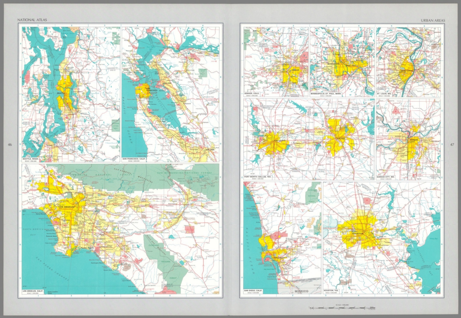
4. Urban areas : Seattle, Wash. -- San Francisco, Calif. -- Los Angeles, Calif. -- Denver, Colo. -- Minneapolis - St. Paul, Minn. -- St. Louis, Mo. -- Fort Worth - Dallas, Tex. -- Kansas City, Mo. -- San Diego, Calif. -- Houston, Tex.
- Author
-
Geological Survey (U.S.), Pecora, William T., Gerlach, Arch C., and Overstreet, William B.
- Subjects
Indians of North America - Abstract
Eleven maps representing urban areas in the United States, as of 1970. Maps show political boundaries, cities, railways, roads, ferry lines, Indian reservations, national forests, mountains, bodies of water, swamps, drainage, coastlines and islands. Relief shown with labeling of mountain names and peak heights. Features population density for each city. Maps include latitudinal and longitudinal lines and scale statements. Colored lithograph. Together, maps are 42 x 65 cm, on double sheet 49 x 71 cm. Index map and legend appear on page 5. Maps appear in General reference maps section., The national atlas of the United States of America, by the United States Geological Survey; published in Washington D. C., 1970. Bound in navy blue board, with title printed in silver on both front cover and spine. Accompanied by envelope with six overlay sheets, tucked between final page and back cover of volume. Collation: [i-vi], vii-xiii, [1], 2-417, A1, A2, B1, B2, C, D. Atlas contains 770 maps and 18 charts. Includes a dedication, foreward, list of contributors, introduction, table of contents and index to map subjects. Topic covered: physical geography, history, economics, culture, administrative boundaries and cartography. In addition, atlas also provides maps of the world, as related to the United States. Maps show political boundaries, cities, railways, roads, topography, bodies of water, glaciers, drainage, coastlines, islands, water depths and time zones. Topical maps feature other details, such as history, geology, climate, agriculture, population, racial demographics (including indigenous peoples), religion, language and transportation. Some maps use data visualization to further illustrate geographical information, with charts overlaid upon the landscape. "Adapted from "About The National Atlas of the United States of America," by the U.S. Geological Survey: The National Atlas of the United States of America was published in 1970. It was designed to be of practical use to decision makers in government and business, and for planners and research scholars as well as others needing to visualize country-wide distributional patterns and relationships between environmental phenomena and human activities. The National Atlas represents the principal characteristics of the country in 1970, including its physical features, historical evolution, economic activities, sociocultural conditions, administrative subdivisions, and place in world affairs. Various federal agencies, professional organizations, and commercial firms had advocated producing a National Atlas of the United States of America, but the magnitude of the task and the scope of the research required deterred those who would begin it. Late in 1954, the National Academy of Sciences-National Research Council established a Committee on the National Atlas of the United States, with representatives from several federal mapmaking agencies. The committee's primary responsibilities were to coordinate all federal agencies that would be involved in producing the atlas and to ensure uniform quality in its cartography. This proved to be a nearly impossible task, and consequently in 1961 the committee terminated itself. In so doing it recommended that the atlas be completed by one federal agency, preferably the Geological Survey in the U.S. Department of the Interior. In March of 1961, the Secretary of the Interior accepted the challenge. Congress appropriated funds to begin work on the National Atlas in 1963, and on reimbursable loan the Library of Congress made available the chief of its Geography and Map Division, Dr. Arch C. Gerlach, to serve as editor. Eighty-four agencies and bureaus appointed liaison officers to the National Atlas Project, base maps were prepared at four scales, and an advisory group of eminent cartographers and geographers collaborated to formulate fundamental design principles and specifications. The first part of the National Atlas is devoted to general reference maps that contain most of the forty-one thousand place names recorded in the index. These maps were included for the convenience of readers wanting basic locational information. In the thematic section of the National Atlas, separate subdivisions deal with the country's physical, historical, economic, and socio-cultural characteristics. The maps in this portion of the atlas represent the relationships between human beings and their environment while offering scientific bases for analyzing the nation's economic development in 1970. The National Atlas proved to be the last paper atlas of this magnitude produced by the federal government."
- Published
- 1970
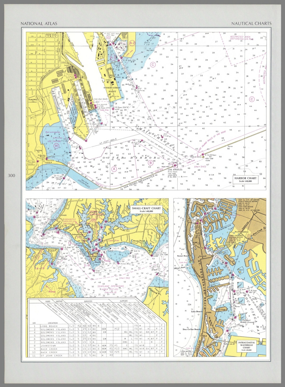
5. Harbor chart : [Los Angeles] -- Small-Craft chart : [Solomons Island] -- Intracoastal waterway chart : [Boca Ciega Bay].
- Author
-
Geological Survey (U.S.), U. S. Coast and Geodetic Survey, Pecora, William T., Gerlach, Arch C., and Overstreet, William B.
- Subjects
Nautical Charts - Abstract
Three nautical charts representing Los Angeles (California), Solomons Island (Maryland) and Boca Ciega Bay (Florida), as of 1968. Charts show cities, roads, topography, bodies of water, drainage, coastlines, islands and water depths. Relief shown with contour lines. Charts include legends, as well as scale statements (scales differ). With a table listing tides, depths, services and supplies. Colored lithograph. Together, charts are 42 x 31 cm, on sheet 49 x 35 cm. Charts appear in Special subject maps section, subsection Mapping and charting., The national atlas of the United States of America, by the United States Geological Survey; published in Washington D. C., 1970. Bound in navy blue board, with title printed in silver on both front cover and spine. Accompanied by envelope with six overlay sheets, tucked between final page and back cover of volume. Collation: [i-vi], vii-xiii, [1], 2-417, A1, A2, B1, B2, C, D. Atlas contains 770 maps and 18 charts. Includes a dedication, foreward, list of contributors, introduction, table of contents and index to map subjects. Topic covered: physical geography, history, economics, culture, administrative boundaries and cartography. In addition, atlas also provides maps of the world, as related to the United States. Maps show political boundaries, cities, railways, roads, topography, bodies of water, glaciers, drainage, coastlines, islands, water depths and time zones. Topical maps feature other details, such as history, geology, climate, agriculture, population, racial demographics (including indigenous peoples), religion, language and transportation. Some maps use data visualization to further illustrate geographical information, with charts overlaid upon the landscape. "Adapted from "About The National Atlas of the United States of America," by the U.S. Geological Survey: The National Atlas of the United States of America was published in 1970. It was designed to be of practical use to decision makers in government and business, and for planners and research scholars as well as others needing to visualize country-wide distributional patterns and relationships between environmental phenomena and human activities. The National Atlas represents the principal characteristics of the country in 1970, including its physical features, historical evolution, economic activities, sociocultural conditions, administrative subdivisions, and place in world affairs. Various federal agencies, professional organizations, and commercial firms had advocated producing a National Atlas of the United States of America, but the magnitude of the task and the scope of the research required deterred those who would begin it. Late in 1954, the National Academy of Sciences-National Research Council established a Committee on the National Atlas of the United States, with representatives from several federal mapmaking agencies. The committee's primary responsibilities were to coordinate all federal agencies that would be involved in producing the atlas and to ensure uniform quality in its cartography. This proved to be a nearly impossible task, and consequently in 1961 the committee terminated itself. In so doing it recommended that the atlas be completed by one federal agency, preferably the Geological Survey in the U.S. Department of the Interior. In March of 1961, the Secretary of the Interior accepted the challenge. Congress appropriated funds to begin work on the National Atlas in 1963, and on reimbursable loan the Library of Congress made available the chief of its Geography and Map Division, Dr. Arch C. Gerlach, to serve as editor. Eighty-four agencies and bureaus appointed liaison officers to the National Atlas Project, base maps were prepared at four scales, and an advisory group of eminent cartographers and geographers collaborated to formulate fundamental design principles and specifications. The first part of the National Atlas is devoted to general reference maps that contain most of the forty-one thousand place names recorded in the index. These maps were included for the convenience of readers wanting basic locational information. In the thematic section of the National Atlas, separate subdivisions deal with the country's physical, historical, economic, and socio-cultural characteristics. The maps in this portion of the atlas represent the relationships between human beings and their environment while offering scientific bases for analyzing the nation's economic development in 1970. The National Atlas proved to be the last paper atlas of this magnitude produced by the federal government."
- Published
- 1968
6. Map of Los Angeles city oil field, Los Angeles County, California, by Chas. A. Blackmar. Issued by the State Mining Bureau, Ferry Building, San Francisco, Lewis E. Aubury State Mineralogist. Trustees: Wm. C. Ralston, President ...

- Author
-
Blackmar, Chas. A. and (California) State Mining Bureau
- Subjects
Mining ,Oil - Abstract
Shows early oil fields in Los Angeles. Printed on paper, in black, with title cartouche in red. Includes a key indicating wells, pumping plants, etc. Map 43 x 62 cm, on sheet 54 x 72 cm. (Date estimated, based upon Wm. C. Ralston's death in 1875; Ralston listed as President of the State Mining Bureau.) (See Pub List No. 3336.000 for other copy.)
- Published
- 1875
7. Map of Los Angeles Historical and Recreational.

- Author
-
Mora, Jo (1876-1947)
- Subjects
Pictorial map - Abstract
This is a special copy printed on tan butcher paper - only 50-100 were made (Gilmore). Dedicated to his friend Charles F. Lummis, noted Los Angeles industrialist, Mora's map of Los Angeles is one of his most "painterly" cartes, with strong colors and shapes spread throughout the map. The map shows early Los Angeles, with the first movie studios and road network. Two versions of the map were printed, one without a title (this copy) and another with the title (see our 8540.000) For more information on Jo Mora's life and works, see http://www.jomoratrust.com, Grandeau & Shorts Cartes 10b; Gilmore M16 (first version without title printed top center).
- Published
- 1942
Discovery Service for Jio Institute Digital Library
For full access to our library's resources, please sign in.