116 results
Number of results to display per page
Search Results
2. Toward a Definition of International and Comparative Library Science.
- Author
-
Harvey, John F.
- Abstract
The newness of a field which librarians are trying to identify and relate to their own concerns and activities is reflected in this paper. It explains the field's research methods and gives examples, as well as discussing its identification and proposing a series of new definitions. In so doing, it is much indebted to the Bereday, Simsova, and Sharify contributions mentioned therein. This is intended to be a pivotal introductory paper. In concluding, the paper proposes that library schools become truly international and teach the best elements from library science world-wide. (LI 004244 through 004256 and LI 004258 through 004267 are related.) (Author)
- Published
- 1972
3. Country Profiles, Iran.
- Author
-
Population Council, New York, NY., Friesen, John K., and Moore, Richard V.
- Abstract
A profile of Iran is sketched in this paper. Emphasis is placed on the nature, scope, and accomplishments of population activities in the country. Topics and sub-topics include: location and description of the country; population--size, number of households, women of reproductive age, growth patterns, role of women, urban/rural distribution, ethnic and religious composition, literacy, economic status, and contraceptive knowledge; population growth and development--national economics and social welfare expenditures; history of population concerns; population policies; population programs--objectives, organization, operations, governmental role, education and communication efforts, and private agencies in family planning; and foreign assistance for family planning activities. Summary statements indicate that program policy is to offer contraceptive information and services through the growing national network of family planning clinics, relying almost exclusively on pills as the contraceptive technique. The strength and sense of urgency of the national commitment can be seen both in the rapidly increasing channeling of talent and financial resources to this effort and in the ambition of national goals for decreasing the current high population growth rate. References and a country map are given. (BL)
- Published
- 1972
4. Dean Vs. Chairman.
- Author
-
Harvey, John F.
- Abstract
This paper deals with the field of library education administration and is based on observation, reflection, and analysis. The author was head of an American graduate library school for nine years, and immediately thereafter, 1967-68, as a Fulbright Professor, headed an Iranian library school for thirteen months. Rather than attempt to compare library education in the two countries, almost as large an undertaking as comparing the two parent institutions, Drexel University (then Drexel Institute of Technology), in Philadelphia, Pennsylvania, and the Faculty of Education, University of Tehran, this analysis focuses primarily on a narrower and more manageable subject, the two positions themselves, dean vs. chairman. This is the story of their comparisons and contrasts, their rewards and problems, one important variable being held constant, the nature of the position as a university graduate library school headship. Most of the comparisons will be made after juxtaposing information from each position, topic by topic. (Related documents are: LI 004245 through LI 004267.) (Author)
- Published
- 1973
5. Locating West and South Asian Research Material.
- Author
-
Harvey, John F.
- Abstract
Although numerous outstanding research collections as well as able professional librarians exist in South and West Asia, many people find Asian libraries difficult to use. Often researchers need specialized data which is hard for them to locate in the limited time available. This paper's purpose is to provide practical suggestions for scholars about overcoming the difficulties of using Asian libraries. It is intended to assist researchers in all fields, including those working on dissertations, and is written to help them change a frustrating and disappointing year into one more rewarding. These remarks are applicable for those parts of Asia which the author has visited: India, Pakistan, eleven more moslem, one Hebrew and one Christian country extending West to the U.A.R. and North to Turkey--and for those researchers whose material location problems are similar to the Asian reference problems with which the author has already dealt. (LI 004244 through 004262 and LI 004264 through 004267 are related.) (Author/NH)
- Published
- 1970
6. Pakistan and Afghanistan Librarianship.
- Author
-
Harvey, John F.
- Abstract
In March and April 1968, the author was a guest of the U.S. Information Service on a two week trip to Pakistan and Afghanistan. During this stay, 30 libraries in five cities were visited. This paper describes this trip and relates the library happenings in these countries. It was obvious that Pakistan librarianship had advanced beyond the profession in either Iran or Afghanistan. There were many more librarians, more of them capable, more curiosity about foreign ideas, more concern for the present, larger book collections, larger buildings, more library schools, more active library associations, and more library publication. Yet all of this development has occurred in university and special libraries, not in school or public libraries, typical of Southwest Asia. And the picture seemed to be standing still or else moving ahead very slowly, as if the librarians had been trained before the nation was ready to support them. There seemed to be no evidence of a surge forward in public libraries, as there was in Iran or of major budget support for university libraries as there was in Ankara. Furthermore, the problem of over population had to be dealt with successfully or there would never be per capita improvement. Since Pakistan's economy was moving rapidly ahead, perhaps good library budgets and new building plans would also come, but one wonders if a country now so poor would support good library service even in the next generation. (LI 004244 through 004260 and LI 004262 through 004267 are related.) (Author/NH)
- Published
- 1968
7. Iranian Vs. American Library Serial Selection Policies.
- Author
-
Harvey, John F.
- Abstract
This essay attempts to compare and contrast certain Iranian and American library serial selection policies. It assumes that many similarities exist between the selection policies of the two countries, but that special problems and contrasts exist in each one, also. The paper concentrates on the policies of two specific institutions, Drexel University, previously, Drexel Institute of Technology, Philadelphia, Pa., U.S.A., and the Iranian Documentation Centre (Irandoc), Tehran, Iran. One is an academic library, the other a government agency documentation center. They are alike in some striking ways but are very different in others. In spite of the absence of data and analyses needed to support an objective study, the author draws two conclusions based on his personal observation and experience. The influence of nationalism on serial subscription policies in Iran and America must be recognized. Probably it is common in libraries over the world to find large numbers of local titles on hand. Also, whenever local pride or nationalism and strong library service ideas are combined, then a rich representation of local serials may be expected, as a way of providing good service to local users. (LI 004244 through 004252 and LI 004254 through 004267 are related.) (Author/SJ)
- Published
- 1971
8. The Iranian Documentation Centre.
- Author
-
Harvey, John F.
- Abstract
The purpose of the Iranian Documentation Centr (Irandoc) was to collect that portion of the world's literature which was pertinent to Iran's research interests, to organize that material, and to promote its use by Iranian researchers. Stated more succinctly, Irandoc's purpose was to obtain ready access to the world's scientific literature in order to improve Iranian research projects. Stated in still another way, Irandoc was (1) building the national science and social science library, (2) providing documentation level services for it, and (3) participating in regional and international information networks. In carrying out these purposes, the Centre collected current book, periodical, document, and report material, organized it, and brought it to the attention of Iranian researchers for use with specific projects. Irandoc's goals included service to the following users: university faculty members, university students, industrial research and development centers, industrial production units, business firms, hospitals, research institutes, government ministries and agencies. In its first three years, Irandoc provided service to these groups plus physicians, engineers, agriculturalists, scientists, chemists, lawyers, educators, economists and others. This paper is a history and description of the establishment and early existence of Irandoc. (LI 004244 through 004251 and LI 004253 through 004267 are related.) (Author/SJ)
- Published
- 1971
9. The Tehran Book Processing Centre.
- Author
-
Harvey, John F.
- Abstract
Establishment of the Tehran Book Processing Centre (Tebroc) was proposed in the Spring of 1968. This document is a descriptive and historical account of the center, and a description of its contributions to Iranian processing development. The center was modeled, to a certain extent, after Bro-Dart's Alanar in Williamsport, Pennsylvania. Tebroc was designed to provide large scale, modern, economic and professional book selection, acquisition, cataloging, classification, and shelf preparation services for Iranian libraries and information centers. All types of libraries were to be served in all parts of Iran. Books in all languages and from all countries, all types and forms of printed and audio-visual materials, all subject fields and English, French, German, Spanish, Persian, and Arabic languages, were to be processed. The organization was Iranian in some ways, western in others, sometimes was very successful, sometimes hopeless. The paper should answer the question, how did this American idea fare in the Iranian library world. (LI 004244 through 004249 and LI 004251 through 004267 are related.) (Author/SJ)
- Published
- 1971
10. Adapting American Library Science for Iranian Use.
- Author
-
Harvey, John F.
- Abstract
Two aspects of comparative library science are discussed in this paper: the adaptation of American library education and of American library standards for Iranian use. Its basic assumption is that all of the goals and most of the essential principles of American library science are as appropriate to modern Iran as to modern America. Furthermore, many practical library procedures can be borrowed from the U.S.A. A further assumption is that the foreigner is seldom familiar enough with Iran to know all of the ideas which should be incorporated or to make all of the changes necessary in adapting either library education or standards for local use. Consequently, Iranian assistance is essential in writing and revising adaptations in both fields. A final assumption is that most Iranians want their libraries improved. (Related documents are: LI 004244 and LI 004246 through LI 004267.) (Author/SJ)
- Published
- 1973
11. Identifying Problems Affecting Adult Literacy Training Programs in the Cento Region; Report of the CENTO Seminar on Illiteracy Held in the National Museum, Tehran, Nov. 16-21, 1963.
- Author
-
Ministry of Education, Tehran (Iran). and Luebke, Paul T.
- Abstract
This volume is the report of the proceedings of a seminar on adult education held in Tehran, Iran. The twelve papers included discuss such topics as adult literacy programs in Iran, literacy in Turkey, adult literacy problems and programs of Pakistan, the purpose of literacy training, defining literacy, planning literacy training programs, motivation in literacy campaigns, using library services to strengthen the literacy drive, the process of communication and audiovisual education, publishing what people will read, and teacher training and personnel selection. (TS)
- Published
- 1964
12. Education for Better Living: The Role of the School in Community Improvement. 1957 Yearbook of Education around the World. Bulletin, 1956, No. 9
- Author
-
US Department of Health, Education, and Welfare, Office of Education (ED) and US Department of Health, Education, and Welfare, Office of Education (ED)
- Abstract
The basic theme of this yearbook, "The Role of the Schools in the Improvement of Community Life," is open to a variety of interpretations. Many factors determine what role the schools will play in a particular country or area, and consequently, what part they may have in community improvement programs. Among the factors are the history and traditions, the economic, political and social conditions, and the culture of the country. Of great importance is the prevailing viewpoint, both among educational leaders and the general population, on the scope and purpose of education. The answer to the question, "To what extent is the school responsible for the type and quality of community living?" will largely determine the extent to which the school will participate in community development programs. This yearbook will describe what is being done in many parts of the world to use education as a creative weapon in the war against instability at the community level. Part I of this document--Some Programs in Action--contains the following papers: (1) The Bolivian Nucleos (Thomas A. Hart); (2) Community Education in Puerto Rico (Fred G. Weis); (3) Community Schools in the Philippines (Jose V. Aguilar); (4) The Role of the Schools in the Development of Community Life (W. E. Baker); (5) The "Schuldorf Bergstrasse" (Friedrich Ploetz); (6) The New Nationwide Program of Fundamental Education in Iran (Luanna J. Bowles); (7) Community Development through Adult Education (Philip Sherlock); (8) The Gold Coast Community Development Service (P. du Sautoy); (9) Fundamental Education at Ubon, Thailand (Richard M. Tisinger); (10) "CREFAL" Trains Teachers for Community Leadership (Horace G. Ogden); (11) Seeing is Believing: Community Education in the British Cameroons (Robert S. Drew); (12) Nomadic Education in Ethiopia (A. I. Sheddad); (13) Education for the Nomadic Tribes of Iran (Glen S. Gagon); (14) The Second Unit Rural Schools of Puerto Rico (Osvaldo Rodriguez Pacheco); and (15) The Community School in a Great Metropolis (Leonard Covello, Simon Beagle, and Leon Beck). Part II of this publication--Some Common Tasks--includes the following: (1) Community Schools of Taiwan--The Growth of an Idea (H. Emmett Brown, Isabelo Tupas, and Henry Yang); (2) College in the Country (J. Carson Pritchard); (3) Producing Instructional Materials in Thailand (Bernice E. Leary); (4) Preparation of Teaching Materials, U.S. Bureau of Indian Affairs (Ann Nolan Clark); (5) A School is Born (Mammo Wolde Senebet); and (6) Getting a Community School Program Started and Keeping it Going (Frederick H. Bair). Part III--Some Common Misunderstandings--includes: (1) Community Education and the Schools (Verna A. Carley; (2) Education and Village Improvements in India (Humayun Kabir); (3) Education and Changing Social Patterns (Samuel C. Adams, Jr.); and (4) The Relation of Education and Other Professions and Resources (Willard W. Beatty). (Contains 32 footnotes.) [The Yearbook Committee members were Bess Goodykoontz, Lane C. Ash, Muriel W. Brown, Paul S. Bodenman, Delia Goetz, Ella W. Griffin, and Frederika M. Tandler. Best copy available has been provided.]
- Published
- 1957
13. EVALUATION OF BACITRACIN DISK FOR THE IDENTIFICATION OF GROUP ‘A’ BETA-HEMOLYTIC STREPTOCOCCI
- Author
-
R.A. Gharagozloo and F. Darougar
- Subjects
Beta-hemolytic streptococci ,Bacitracin paper disk ,Iran ,Public aspects of medicine ,RA1-1270 - Abstract
A total of 711 beta-hemolytic streptococci were isolated from throat cultures of patients during 1970-73. These strains were grouped in parallel by the precipitin and bacitracin paper disk method. The former method was established as the standard by which the bacitracin technique was compared. The difference in results was about 5.67%. The greatest error (5.4%) was seen with non-group A strains being sensitive to bacitracin. In spite of this, it was shown to be advantageous to use the bacitracin disk for primary isolation from throat cultures rather than to consider all beta-hemolytic streptococci isolated as group A, which would give a magnitude of error around 16%.
- Published
- 1974
14. The Comparative Study of Iran-Turkey Public Diplomacy in Iraq and Syria
- Author
-
Seyed Asadollah Athari, Ali Enayati Shabkolaei, and Seyed Muhammad Amin Husseini
- Subjects
iran ,turkey ,iraq ,syria ,public diplomacy ,soft power ,Islam ,BP1-253 - Abstract
The paper attempts to investigate the Iran-Turkey public diplomacy in Iraq and Syria after changes in these countries. Iran and Turkey as two effective powers on the Middle East changes try to enforce their goals and policies of public diplomacy in Iraq and Syria based on the nature of states. The main questions are: how is the Iran-Turkey public diplomacy in Iraq and Syria? What are the effects of new changes in these countries on the Iran-Turkey public diplomacy? To respond those questions, the hypothesis of paper is that Iran and Turkey use both their public diplomacy (soft power) and hard power, in their regional competition, in order to stabilize and enhance their regional hegemony. Both countries have some different facilities and opportunities to take advantage of the public diplomacy in Iraq and Syria, but their relative success depends on their strategies and such successes and failures are not perpetual and in all situations. This paper applied the descriptive-analytical methodology and collected the data by the documentary-library instrument.
- Published
- 1393
15. Asie Meridionale : comprenant la presqu'île de l'Inde, la Perse, l'Afghanistan et le Beloutchistan. Paris - 1862. E. Andriveau-Goujon. Rue du Bac. 21. Dressee par A. Vuillemin. Grave le trait et les montagnes par Gerin; les Ecritures par P. Rousset. Les Eaux par Mme. Fontaine. Imp. A. Chardon. (to accompany) Atlas classique et universel de geograparphie ancienne et moderne ... Nouvelle edition. 1863.

- Author
-
Andriveau-Goujon, Eugene, Vuillemin, Alexandre Aime, 1812-1886, Fontaine, Mme., Gerin, Rousset, P., and Chardon, A.
- Subjects
- India, Iran, Afghanistan, Pakistan, South Asia, Asia
- Abstract
Hand color map. Shows political boundaries and possessions of European in South Asia. Relief shown by hachures. Includes explanation., New edition of the classic and universal atlas of ancient and modern geography. Edited and published by J. Andriveau-Goujon in 1863. Adopted by the Minister of War for regimental libraries. Containing 50 plates, 49 hand double page or folding maps, dated 1854-1863, and 1 plate includes Flags of the nations. Some maps on 2 or more plates. Maps showing the most recent exploration, discoveries, and historical work on geography, political and administrative boundaries, major cities, villages, forts, coastal cities, canals, rivers and mountains. Includes descriptive text. In and mountains. Relief shown by hachures and pictorially. Plate 21 has been repeated (21 & 21A) bound after plate 22. Atlas contains descriptive text and index. Handwritten label in pencil indicating the title. Bound in quarter leather brown marbled paper covered boards with a green paper label reading "Atlas classique & universel de geographie ancienne et moderne. Publie par J. Andriveau-Goujon." The spine is embossed with "Andriveau. Atlas universel" in gilt.
- Published
- 1862
16. Box1_36 plate

- Author
-
Anonymous and Bey, Abdürrahim Hilmi
- Subjects
Ottoman Mapping - Abstract
"This is an extraordinary privately assembled encyclopaedia, focused on Mecca as the Navel of the World. Written in manuscript in thin black and red pens in Ottoman language, it contains over 580 pages of manuscript in tiny characters, sometimes accompanied with charts, over 380 manuscript maps, made with extreme care in precision in colours and with gold and silver highlights, over 225 prints from magazines, books, atlases and other sources from the late 19th and early 20th centuries, often joined in collages and compositions with hand-drawn maps. The maps are made with a greatest precision in well planned configuration. The colours are carefully applied to give an instant effect of a modern data visualisation. The gilt highlights and small details in black ink express the author’s endless patience and dedication to the project. The manuscripts, maps and illustrations are tastefully and carefully joined together thematically in foldouts and pamphlets, bound together with linen or paper stripes or strings. Shorter subjects and uncut plates also appear as separate leaves. We could count 217 such separate units. The whole collection is housed in three charming boxes, possibly made by the author from commercial boxes and leftovers of the linen, which he used for drawings of some of the maps. The anonymous author, doubtless a Muslim intellectual, took the information from the contemporary sources and atlases and smartly combined them in his own unique compositions. He also often added his own annotations, colouring and keys to the prints, which he took from the books and magazines. The manuscripts give an impression of a coherent collection, which was probably never meant for a publication. It was possibly an author private project, to which he dedicated years or decades of his life. It is possible that the collection was meant for a private education. Focus on Mecca The maps with geographic, historic and thematic data focus on the Arabian Peninsula with Mecca as a center. Throughout the series the city is often smartly positioned in the middle of the folds, to give the impression, that the world and around it opens like a flower. In the collection we could trace approximately 23 maps, where Mecca is represented in the central point of the world, 24 maps showcasing only the Arabian Peninsula or parts of it or / and the Red Sea, circa 25 maps of Mecca or/and its surroundings and sketches of the Kaaba and 11 views and prints of Mecca. The latter ones have been taken from other publications and integrated into the encyclopaedia by the author. Medina is represented with two manuscript maps and 8 views. The views here are as well taken from other publications. Separate pamphlets also focus on the history of the Arabian Peninsula and the history of its inhabitants with a chart on the tribes of Arabia. With this work the author geographically represented Mecca as the central point, a navel of the global culture and history from the ancient times up to the present days. Other Subjects The pamphlets and fold-outs are bound together thematically and represent the cultures, history and geography of the World from its beginnings until the early 20th century. The manuscript units with maps, charts and illustrations describe subjects such as geology, time through the Ottoman time charts, astronomy and astrology, ancient cultures and monuments (Babylon, Mesopotamia, Ancient Greece, Baalbek etc.), old geographic representations, such as Tabula Peutingeriana and parts of Fra Mauro’s map, America on old maps, discoveries on America and later discoveries and explorations, thematic maps of the world and parts of the world etc. A large portion of the maps is dedicated to the Mediterranean Basement (ca 152 maps) and the Balkans, with the large Ottoman battles. The other maps focus on Asia, America (ca 5 maps of North America, 2 maps of Central America), other continents and the whole world (27 maps of the world). The author seems unattached an ambivalent to Istanbul and Turkey, as the region is almost neglected in the manuscripts, which is the opposite of the contemporary glorification of the newly founded Turkey and the magnificent history of Istanbul. Also hardly represented are the African regions, including the Muslim ones. It is possible, that the author spent most of his life on the Arabian Peninsula and was not attached to the cultural and political center Istanbul. Authorship and Date The author of the work is not signed, neither are the maps dated. According to the attached note, the collection was allegedly connected with the family of the Turkish writer Ahmed Cemil Akıncı (1914-1984). His father and a possible author, Abdürrahim Hilmi Bey (Sipahizâde) was of Sipahi origins from Rumelia and was educated at the Fatih Madrasa in Istanbul. Hilmi Bey was in charge for the railway and education in Egypt, Palestine, Syria and Hejaz, where he spent a large part of his life. This would explain the author’s unattachment to Istanbul and Turkey. The paper, style and material of the boxes indicate the late 1910s and 1920s. Some of the maps confirm this period of time: a series of thematic world maps (possibly drafted after a contemporary Ottoman atlas) showcase the world in 1915 (1331 Rumi years). An illustration from a magazine, representing a map A Child’s Map of the Ancient World, by Alice York and Ilonka Karasz, was published in 1926. It is the youngest dated document, which we could trace in the collection. References: Unrecorded. [S. l., s. d. Possibly Ottoman Empire / Turkey, late 1910s-1920s]. A magnificent hand-written privately assembled encyclopaedia of the World, affectionately assembled and curated by an enlightened Muslim scholar in the last years of the Ottoman Empire, with over 580 text pages and 380 hand drawn detailed maps with gilt highlights, represents Mecca as the Navel of the World and the connecting point between the ancient civilisations and culture and the modern East and West. Collation: 3 red privately custom-made boxes, constructed of thick card with red linen surface with debossed lettering and decoration, patterned paper mounted inside, each with a black cloth loop with a knot, edges originally reinforced with linen, some linen parts with details of manuscript maps, 9 x 14 x 20 cm (3.5 x 5.5 x 7.8 inches). The boxes contain: - 217 separate units of fold-outs (leporellos), pamphlets and maps composed of sheets of paper, privately joined with straps of linen, sporadically also with stripes of paper or bound together with a sting. Most units with 4-8 pp., but also single sheet units and pamphlets with up to 16 pp. manuscript text. Most of the text accompanied with manuscript maps, mostly mounted verso. Some manuscript maps on loose linen waxed paper. Also includes sporadic single prints from books and magazines and postcards, not edited by the author. - The 217 units include: - - Over 580 manuscript text pages, some with charts in text, plus additional text comments and keys. Black and red ink on paper of various quality and thick card, each 18 x 11,5 cm (7 x 4.5 inches) when folded. - - More than 380 manuscript maps, including multiple maps on one sheet and folding maps. The maps are mostly mounted or drawn on cards on the inner side of the fold-outs and pamphlets, on the back of the text sheets. Some manuscript maps on loose waxed linen paper sheets. Most of the maps are ornated with gilt highlights. Black, purple and red ink and water colours on paper and linen paper, from 18 x 11,5 cm to 18 x 44 cm (7 x 4.5 inches to 7 x 17.3 inches), mostly mounted on the back of text pages, but also loose sheets. - - More than 225 prints, mostly mounted in compositions with maps, pictorial panels and more than 35 collages. The prints of various, mostly small sizes include maps, lithographs, chromolithographs, steel engravings, wood-cuts, postcards (cut and uncut), photo-reproductions, illustrations from books and magazines etc. Some prints (mostly illustrations from books and postcards) are added as unedited and uncut sheets. The prints have been taken from mostly Ottoman, but also German, French and English publications. Various techniques, some with manuscript annotations in black ink or with hand colour. - Additional unsorted sheets of manuscript and illustrations. Condition report: Boxes with some staining and minor wear on the edges, manuscripts and maps overall in a good clean condition with minor staining, foxing and wear. Sporadic maps and manuscripts are left unfinished." (Alexander Johnson and Dasa Pahor, 2020)
- Published
- 1918
17. Persia. Drawn by A. Arrowsmith. Engraved by Sidy. Hall. Published, 1817, by A. Constable & Co. Edinburgh and Longman & Compy., London.

- Author
-
Arrowsmith, Aaron, Corbould, H., Heath, Chas., Hall, S., and Thomson & Hall.
- Subjects
- Iran, London
- Abstract
First edition of Arrowsmith atlas published in 1817. Although the maps are not large, they are dense with information. This complete atlas features index and 53 copperplate maps, drawn by Arrowsmith and engraved by Sidney Hall, with a few engraved by Thomson in collaboration with Hall. The maps include two world, 29 related to Europe and Scandinavia, 16 on Asia, Africa, and Oceania, and six related to the Americas. The United States map shows Georgia extending from the coast to the Mississippi River. The area west of the Mississippi is blank and labeled Louisiana. Engraved title page has Atlas holding the globe above two putti, one sailing a dingy, the other engaged in cartographic studies with a globe, map and dividers. Hardbound with marbled paper and original paper label printed with "Arrowsmith's New General Atlas Comprehended in Fifty three Maps From Original Drawings. Price L 2,12,6. coloured". Black leather spine has a label embossed with "Atlas (18)17" in gilt. Maps have original outline color, with many tissue guards still in place., First edition of Arrowsmith atlas published in 1817. This complete atlas features index and 53 copperplate maps, drawn by Arrowsmith and engraved by Sidney Hall, with a few engraved by Thomson in collaboration with Hall. The maps include two world, 29 related to Europe and Scandinavia, 16 on Asia, Africa, and Oceania, and six related to the Americas. The United States map shows Georgia extending from the coast to the Mississippi River. The area west of the Mississippi is blank and labeled Louisiana. Engraved title page has Atlas holding the globe above two putti, one sailing a dingy, the other engaged in cartographic studies with a globe, map and dividers. Hardbound with marbled paper and original paper label printed with "Arrowsmith's New General Atlas Comprehended in Fifty three Maps From Original Drawings. Price L 2,12,6. coloured". Black leather spine has a label embossed with "Atlas (18)17" in gilt. Maps have original outline color, with many tissue guards still in place.
- Published
- 1817
18. Asie Occidentale, Turquie d'Asie, Arabie, Perse, Turkestan, Afghanistan & Beloutchistan. Atlas spheroidal & universel de geographie dresse par F.A. Garnier, geographe. Paris, Ve. Jules Renouard, Editeur, R. de Tournon, no. 6. 1860. Imp. de Sarazin, 8, r. Git-le-Coeur, Paris.

- Author
-
Garnier, F. A., 1803-1863, P.-A. Bourdier et Cie., and Sarazin (Firm)
- Subjects
- Afghanistan, Arabia, Iran, Pakistan, Turkey, Paris, Middle East, Asia
- Abstract
Full col. Relief shown by hachures. Prime meridian: Paris. On globe in cartouche: Sphericite de la terre., This atlas is exceptional for its "spheroidal" maps of the globe, showing the various continents and poles, shaded to give the effect of a sphere floating in space. The remaining maps are also very well executed and colored, mostly by hand, a few in colored litho. In recent years, this atlas has become rare in the trade. This is the only atlas that Garnier produced, according to Phillips. Tooley lists an 1860 edition. Covers are quarter leather marbled paper covered boards with a paper label; the burgundy leather spine is embossed with "F.A. Garnier. Atlas Universel et Spheroidal de Geographie" in gilt. On verso of half-title: Paris -- Imprimerie de P.-A. Bourdier et Cie., Rue Mazarine, 30., Phillips, 836.
- Published
- 1862
19. Imperium Persicum Antiquum. Published by Cummings & Hilliard, No. 1, Cornhill, Boston. W.B. Annin, Sc. (to accompany) An Ancient And Modern Atlas, Containing Thirteen Ancient And Eight Modern Maps.

- Author
-
Cummings, Jacob Abbot and Annin, William B.
- Subjects
School ,Classical - Abstract
Engraved outline hand color map. Relief shown pictorially., Cummings’ Atlas, published by Cummings and Hilliard. A very well printed edition of the same eight modern maps as the "School Atlas" (6th edition) plus thirteen ancient maps and a plan of the Temple of Jerusalem. Outline hand color maps, engraved by M. Butler, T. W. Wightman, and W. B. Annin. Showing political and administrative divisions, major cities and town, rivers, canals, lakes and mountains. Relief shown by hachures and pictorially. Prime meridian: Greenwich. The plate marks are clearer and the impressions much stronger and the paper better than the school atlas. The content on title page listing 2 fewer ancient maps. Covers are half leather, marbled paper covered boards with no title.
- Published
- 1817
20. General-Karte des Türkischen Reiches in Europa und Asien nebst Ungarn, Südrussland, den kaukasischen Ländern und West-Persien. Entworfen u. bearbeitet von Heinrich Kiepert. Berlin, verlag von Dietrich Reimer, 1855. Mit Nachträgen und Berichtigungen 1877. Stich und Druck der lithographischen Anstalt von L. Kraatz.

- Author
-
Kiepert, Heinrich and Kraatz, Leopold
- Subjects
Ottoman Mapping - Abstract
Case map of the Ottoman Empire. Colored lithograph on paper, sectioned and mounted on linen, which is folded and inserted within a case made of black board. Shows political boundaries, railroads and water routes, as well as ethnic divisions. Includes legend and three bar scales. Features a table: Erklärung häufiger geographischer Benennungen in den vier Hauptsprachen des Orients: Türkisch, Arabisch, Persisch, Ost-Slawisch, Russisch ... (= Explanation of common geographical names in the four main languages of the Orient: Turkish, Arabic, Persian, East Slavic, Russian.) Map 84 x 119 cm, on sheet 88 x 123 cm, folded to 31 x 22 cm, inside case 33 x 24 cm., Case map of the Ottoman Empire. Colored lithograph on paper, sectioned and mounted on linen, which is folded and inserted within a case made of black board, with title in gilt. Map 84 x 119 cm, on sheet 88 x 123 cm, folded to 31 x 22 cm, inside case 33 x 24 cm.
- Published
- 1877
21. Persia. Neele sculp. Published Jany. 1st. 1819, by Pinnock & Maunder Strand.

- Author
-
Pawley, Neele, Samuel John, 1758-1824, Neele, George, Pinnock and Maunder, and Samuel & George Neele
- Subjects
- Iran, London
- Abstract
Map of Persia [Iran] and vicinity. Shows political boundaries, cities, railroads, topography, major lakes and drainage, coastlines and islands. Features historical note: Here Pr. A. Beekewitz with 3000 men were massacred by the Usbecks in 1717, according to Bruce. Relief shown with hachures. Includes latitudinal and longitudinal lines, as well as a compass rose and bar scale, given in British statute miles. Hand-colored engraving, including illustration of clouds behind title. Map is 22 x 27 cm, on sheet 26 x 34 cm., Pawley's minor atlas, published in London by G. and W. B. Whittaker, 1822. Bound in board, covered with faded red and blue marbled papers. End papers comprised of the same marbling, but not faded. With leather spine and corners. Gilded spine title: Pawley's minor atlas. Collation: 2° : [1] page, [2] plates, I-XXXVI, [XXXVII], XXXVIII-XLIII leaves of plates, [1] page. First and last pages are blank. Forty-three plates containing 43 maps. All double plates except for II-V. Engraved title page and index. Title page dated 1822; Index and all maps dated 1819, with the exception of the map on plate XVII, which is dated 1823. Maps dated 1819 have the imprint Pinnock & Co. Strand or Pinnock & Maunder Strand. Maps show political boundaries, cities, railroads, routes, topography, deserts, vegetation, major lakes and drainage, coastlines and islands. Maps of North America also feature the indigenous peoples living therein. Maps include latitudinal and longitudinal lines, as well as compass roses, bar scales and historical notes. Hand-colored engravings.
- Published
- 1819
22. Persia, Arabia &c. 65. (1848)

- Author
-
Bourquin, Frederick, Mitchell, Samuel Augustus, and Tanner, Henry S.
- Subjects
- Iran, Saudi Arabia, Philadelphia, Asia
- Abstract
Lithographed. Relief shown with hachures.Map printed on lightweight paper and tipped., This is a unique copy of the Mitchell/Tanner Universal Atlas. Frederick Bourquin and his employer, Peter Duval, received a Third Premium Award from the Franklin Institute in November, 1848, for their achievement in transferring the Universal Atlas from copper plates to lithographic stones. The catalog of the exhibition lists it as "No. 52. Universal Atlas in folio, a most beautiful specimen of the art of transferring and lithographic printing, from the press of P.S. Duval, Philadelphia, transferred by Bourquin." This copy of the atlas was their submission to the Franklin Institute to be considered for the award. It is made up of sheets from the atlas, all uncolored, all oversized, and all taken from various editions of the atlas from 1846 to 1848 (one map is dated 1849, but we believe it was issued in late 1848). It appears that these sheets were offprints that remained in the lithographer's shop and that the atlas was made up from them. Atlas is bound in half leather marbled paper covered boards with leather label on the front reading "Atlas Transferred From Copper To And Printed From Stone By Frederick Bourquin." The atlas stayed with the Franklin Institute, each page having the Institute's stamp on it, and was eventually sold by the Institute in the mid twentieth century. There are several erasures of dates that are earlier than 1848 (perhaps an attempt to make the book seem up to date) and several erasures of Tanner's name (on the title page) to conform to the fact that in 1848 this was known as Mitchell's atlas. The map borders vary between the "Mitchell" and the "Tanner" borders. And the paper thickness and quality varies as well. These sheets may have been some of the first "pulls" of each map in the various 1846-48 editions. This is a fascinating compilation and throws light on the transition in printing from copper plate to lithographic stone., Ristow p. 311 (award actually received in 1848).
- Published
- 1848
23. Persia. Drawn by J. Wyld. Engraved by Hewitt. Published by John Thomson & Co. Edinburgh. (to accompany) A General Atlas, Containing Maps illustrating some important periods in Ancient History; and distinct Maps of the several Empires, Kingdoms and States In The World, From Original Drawings according to the latest Treaties by J. Wyld and Engraved by N.R. Hewitt. Edinburgh, Printed for John Thomson & Co for Baldwin, Cradock & Joy, London & John Cumming, Dublin.

- Author
-
Thomson, John, Wyld, James, 1790-1836, Lizars, W.H., and Hewitt, N.R.
- Subjects
Classical - Abstract
Detailed map, with outline colored boundaries. With a vignette "View of Mt. Ararat". The atlas is the second edition and includes the extra map of the Arctic and two extra maps of Australia. The text adds a section on Voyages of Discovery. Two additional maps are laid in, one of South America, the other of Mexico. Each map has a small vignette illustrating a subject related to the map. Half leather paper-covered boards with label pasted on front printed with title. Prime meridian is Greenwich. Relief shown pictorially., This is the second edition and includes the extra map of the Arctic and two extra maps of Australia. The text adds a section on Voyages of Discovery. Two additional maps are laid in, one of South America, the other of Mexico. Half leather paper-covered boards with label pasted on front printed with title., cfP6043.
- Published
- 1824
24. SEROLOGICAL AND PARASITOLOGICAL OBSERVATIONS ON MALARIA IN SOUTHERN IRAN
- Author
-
Gh. H. Edrissiaon and A. Afshar
- Subjects
Malaria ,P. falciparum ,P.vivax ,Iran ,Public aspects of medicine ,RA1-1270 - Abstract
In the course of serological and parasitological studies of malaria, 1,018 persons were examined. They were from four different areas (A, B, C and D) in the region of Bandar Abbas and 1-1ina), southern Iran, where malaria is still endemic. For the serological examinations, the IFAT was used with P. falciparum and P.vivax antigens. Several FA-positive reactions were observed in young children, most probably due to congenital antibodies. In areas A, B, and particularly in area C, the sero-positivity rates indicate that malaria control measures have been relatively effective in recent years. The sero-positivity related to increasing age, and virtually negative in the younger age groups. Parasitological findings how that more positives were found, by concentration technique than by the routine examination of thick blood films. This indicates that routine blood examination of fever cases is not able to show the real infection rate in areas where malaria is still endemic· A comparison between the serological readings obtained with extracts from 204 blood specimen on filter paper and those produced by genuine plasma samples has yielded practically identical results.
- Published
- 1974
25. TRAINING OF THE MALARIOLOGISTS
- Author
-
M.A. Faghih
- Subjects
Malaria ,Malariologist ,Epidemiologist ,Iran ,Public aspects of medicine ,RA1-1270 - Abstract
With the recent changes in the status of malaria and in the strategy of malaria eradication, and with more emphasis given to the planning of .the anti-malarial campaign within a coordinated health and socio-economic development plan; with the, betterment of methodology for comprehensive health planning and the refinement of administration and management techniques; and with rapidly increasing medical knowledge and technology; there is need for a revision of the programs for the training of the professional malaria staff, particu1arly the "malariologist".In the present paper, the above changes and developments as well as the experience gained are reviewed, the profile of an ideal epidemiologist malariologist is given, and the pattern of the program for the training of such a person, including basic, special and advanced training, is described and, wherever necessary, is exemplified.
- Published
- 1974
26. A PRELIMINARY STUDY OF MEDICATED SURMEH (A NATIVE MASCARA POWDER) BY BIOLOGICAL METHOD
- Author
-
H. Mohsenin and Kh. Moradpour
- Subjects
Trachoma ,Blepharitis ,Iran ,Public aspects of medicine ,RA1-1270 - Abstract
Trachoma, especially its complications, is more prevalent in females than in males. In some of the rural areas of Iran, the use of "Surmeh" is a prevalent practice. A biological test was carried out to determine the benefit of using this social custom by means of medicated surmeh for the control of trachoma and other infectious eye disease. Surmeh is smoked carbon powder, with a little oil added, which is used for beautifying the eye-lashes and eye-lids of women. Surmeh could transmit bacterial eye diseases, but its effect on the transmission of trachoma is not yet proven. In preparing medicated Surmeh almond oil is used, but other cheap, non-allergiant oils may be substituted. Seventy tests for three kinds of medicated surmeh were performed, i.e., 1. surmeh plus 1% aureomycin; 2. surmeh plus 3% aureomycin; 3. surmeh plus about one-thousandth methylene blue. The biological test is the same as the usual bacterial sensitivity test, i.e., a stock isolated sensitive staphylococcus is cultured on blood agar plate and round disc papers ,with eye secretion are put on the plate. The tests showed that all three medicated surmeh were effective and have considerable residual effects up to 8 hours. In few occasions the residual effect was lasting even up to 16-23 hours. The residual effects of medicated surmeh are nearly the same as those of antibiotic eye ointments. Medicated surmeh may be used for the treatment of blepharitis. It seems that medicated surmeh is also effective in trachoma control, especially for the prevention of trichiasis. Medicated surmeh can be prepared in the field by making a condensed oil suspension of the effective drug and mixing 2-3 drops in each of the women's surmeh pots. Health education is needed for the proper use of surmeh in areas where its use is common, and precautions must be taken to prevent the spreading of this social custom.
- Published
- 1974
27. Les identifications de Gayomart à l'époque islamique
- Author
-
Sven Hartman
- Subjects
Islam ,Gayōmart (Zoroastrian mythology) ,Syncretism ,Iran ,Bible, Old Testament ,Religions -- Relations ,Religion (General) ,BL1-50 - Abstract
In this paper, the author explores who was identified as the First man in the context of the arrival of Islam in Persia. Was Gayomart the first man, or Adam, or are they the same person? This question was not only religious but also political, as they represented two different peoples, the Persians and the Arabs.
- Published
- 1969
- Full Text
- View/download PDF
28. II. Tab. 2. Perser = Persans.

- Author
-
Klinger, Johann Georg, 1764-1806 and Müller, Johann Wolfgang
- Subjects
Ethnography ,Nationality ,Race - Abstract
View representing figures indigenous to current-day Iran, wearing their traditional attire. The background shows figures, camels with packs, buildings, and a hilly landscape. With text in German and French. Hand colored engraving. View is 9 x 9 cm, on card 10 x 9 cm. Appears in II. Asiatiques., Description de differens peuples remarquables des cinq parties du monde avec des figures representant leur costume national by Jean Wolfgang Müller and Jean George Klinger. Published by Klinger in Nuremberg, Germany, in 1807. Second edition. Title translates to: Description of different remarkable peoples from the five parts of the world with figures representing their national costume. Board game featuring one world map and one map each of Europe, Asia, Africa, North America and Australia, as well as views of specific indigenous groups for each of those five regions. The game is housed in a box, which is decorated with marbled papers and features a pasted-on, hand-colored engraving of a European explorer amidst a group of indigenous people, all surrounding the title cartouche. The box contains a booklet of descriptive text, world map, game board, 4-page sheet of instructions, and five slipcases, each housing a map of a continent with views of figures indigenous to specific regions, wearing their traditional attire. Each view is accompanied by captions in German and French. The accompanying booklet contains detailed descriptions of the attire, diet and lifestyle of each indigenous group depicted. Pagination: [I-III] IV-SVI, [1-2], 3-127 pages. The game was a collaboration between geographer Klinger and gamemnaker Müller. A German first edition was published in 1801, followed by this second edition in both German and French in 1807. Klinger (1764-1806) was a German map, globe and game maker active in Nuremberg during the early to mid-19th century. He was consider the most prominent globe maker of his generation. Müller (1765-1828) was a Nuremberg-based educator and publisher of playing cards and other games.
- Published
- 1807
29. (Composite map to) (sheets) I-XII

- Author
-
Chesney, Francis Rawson (1789 - 1872)
- Subjects
- Iraq, Syria, Iran, Kuwait, Middle East
- Abstract
"Rare – the complete set of 12 connecting charts (that if joined would measure approx.. 2 x 4 metres!) showcasing the first scientific survey of the Euphrates and Tigris Rivers, the result of an incredible expedition led by Colonel Francis Rawson Chesney who traveled by steamboat 1,200 miles down the entire navigable length of the Euphrates, from Birecik, Turkey, down through Syria and Iraq, to the Persian Gulf, in order to prove the feasibility of a new short travel route between India and Britain; while the commercial exploitation of route never materialized, Chesney’s survey had a grand legacy, as its charts served as the authoritative source maps of the Euphrates an Tigris for decades, the blueprints for political, military and commercial activities and scientific and archaeological discovery – one of the great masterpieces of inland hydrography of the 19th century. In the 1830s, Britain was on the top of the world, having built a massive Asian empire consolidated upon its domination the Indian Subcontinent. However, it had a major challenge in that the established transport routes from Britain to India were either incredibly long (around the Cape of Good Hope) or unpleasant and dangerous (traversing Egypt’s Suez Isthmus overland and traveling down the pirate-infested Red Sea route). Enter Colonel (later General) Francis Rawson Chesney (1789 - 1872), an extremely enterprising British army officer. He politically well-connected, being the protégé of Lord Rawdon (later the 1st Marquess of Hastings) who served as the Governor-General of India (1813-23). In 1829, Chesney was sent on a special mission to the Ottoman Empire, whereupon he made many reconnaissance surveys. This led him to draft a well-reasoned proposal to build a canal across the Suez Isthmus that later proved highly influential (Ferdinand de Lesseps, who eventually completed the Suez Canal in 1869, addressed Chesney the “father” of the canal when they met in Paris). However, it was clear that during the 1830s the technical and financial resources, let alone the right political circumstances, were not right for building such a grand project. Chesney next prosed to the British government that they should consider creating a travel corridor from India to Europe via the Euphrates River, which ran for 2,800 from the highlands of eastern Anatolia down through the Syria and Iraq, before meeting the Tigris, forming the Shatt-al-Arab, before entering the Persian Gulf at the border of Ottoman Iraq and Persia. This river was known to be navigable for many hundreds of kilometres above the sea, while its tributary, the Tigris, was navigable up to Baghdad. As the relatively new technology of steamships was then revolutionizing global travel, he proposed that shallow draft steamships could be used to travel from the Persian Gulf up into Anatolia, and that from there passengers and freight could travel overland to the Mediterranean. Eventually, a railway could be built from the head of the navigation of the Euphrates to the Mediterranean, although that would be well into the future. Id realized, this plan would create by far and away the shortest distance travel route between India and Britain. The Euphrates route was also geopolitically convenient for London, as not only was the weak Ottoman Empire malleable (desperately seeking cooperation with Britain), but a British operation to protect a permanent travel route up through Mesopotamia and Anatolia would act as a deterrent to Russian aggression in the greater region (Britain and Russia were then squaring off in the first Cold War, ‘The Great Game’). While the Euphrates was then navigable for up to 1,200 miles above its embouchure, the Euphrates and Tigris had never been surveyed in serious, scientific fashion, such that the nature and extent of the navigability of these great streams was not known. Beginning in 1832, Chesney fiercely lobbied Whitehall for funds and resources to mount steamship expedition down the entire navigable length of the Euphrates, methodically mapping the river and its major tributaries, as well as conducting scientific and cultural research. Fortunately, he had friends in high places; it helped that King William IV, a career naval officer, was very enthusiastic about the project. In 1834, Chesney’s plan was approved by the government and Parliament voted to give £20,000 to find the project, then a very large sum. Two prefabricated steamboats of an ingenuous design, that could be disassembled and reconfigured, were custom-built for the expedition in Liverpool by the firm of John Laird. The vessels were fittingly named the Euphrates and the Tigris. Chesney managed to recruit an all-star team of military officers and scientists to guide the technical and academic aspects of the mission. This included the explorer Henry Blosse Lynch of the Indian Navy and the geologist William Francis Ainsworth, president of the Royal Physical Society of Edinburgh. He also assembled a crew from the Royal Artillery, Royal Sappers and Miners with professional skills and field experience in operating steam machinery, surveying and drawing. Chesney and his team were enthusiastic not just about mapping the Euphrates but also about the ethnographic, scientific and religious studies that the trip afforded, as “the country about the sources of the Euphrates and Tigris was the seat of [Biblical] Paradise!”. However, Lord Ellenbourgh, the president of the Board of Control for India, reminded the team that they should “always bear in mind that [the practicability of navigating the Euphrates] is the one object of your expedition, and that scientific inquiries, however interesting, are no to be allowed to detain you”. Chesney and his party set out from England for the Mediterranean early in 1835, arriving at the Gulf of Iskenderun, on the frontier of Anatolia and Syria, in March of that year. The men transported their equipment and the disassembled steamships over 140 miles of rough terrain to Bir (Birecik in modern Turkey), on the banks of the Euphrates. There, they created an improvised shipyard and assembled the vessels. They then set out down the river from a point that was about 1,200 miles above the sea. As the river’s course was little known, the trip proved extremely dangerous, as they had to negotiate a variety of hazards, even though navigable passages were always inevitably revealed. While Chesney was careful to maintain good relations with the Kurdish, Assyrian and Arab tribes that resided along the banks of the rivers (forging links that would be vital if a regular river transport corridor were to be opened), misunderstandings almost resulted in tragic altercations on several occasions. Worst of all, the Tigris was lost, vanishing during a sudden, freak storm, with it and its crew never to be seen again! Yet, the expedition persisted (fortunately Chesney and the principals of the expedition survived, as they were aboard the Euphrates). All along the way, Chesney and his men conducted exacting systematic hydrographic surveys to the highest standards. Geodetic basepoints at key junctures were ascertained by astronomical observations, while careful bathymetric soundings and accounts of the currents were taken. Observations were made of magnetic deviation and meteorology, while the party gathered geological, botanical and biological specimens. They also carefully recorded archeological sites, as well as taking careful notes on the local tribes, so executing the first comprehensive scientific reconnaissance of Mesopotamia. In addition to mapping the entire navigable length of the Euphrates from Birecik to the Persian Gulf, the party ascend the Tigris River for the Shatt-Al-Arab up to Baghdad, mapping the river with same care. Towards the end of the expedition, a side party ascended the Karun River, in Persia, which was major tributary of the Shatt-Al-Arab. The entire expedition was completed in early 1837. Critically, Chesney and his team had proved that the Euphrates was navigable for steamships from the Persian Gulf all the way up to Birecik, which was only 140 miles from the Mediterranean. This opened what was by far and away the shortest route from India to Britain (especially if a railway could someday be constructed between Birecik and Iskenderun). Chesney returned to London later in 1837, with has manuscript maps, watercolours, sketches and notes. His endeavor was immediately hailed as a tour de force, and many in government were highly enthusiastic about open the Euphrates India-Britain route. However, Britain soon became involved in the horrific disaster of the First Anglo-Afghan War (1839-42), which distracted the powers that be from pressing on with the Euphrates project. Moreover, for much of the 1840s, Chesney was deployed to serve in the Far East and so had trouble finding the spare time to work on publishing his maps and papers, let alone lobby for its advancement. Thus, the Euphrates plan remained ‘on ice’ during what was a decisive period. By the time that Chesney’s lavish account of the Euphrates expedition (including the present charts) were published in London in 1849-50, much of the momentum that once existed behind the Euphrates plan had dissipated. Ironically, it was Chesney’s 1829 feasibility study for the Suez Canal that ultimately killed his Euphrates plan, for his ideas for the former were adopted by his admirer Ferdinand de Lesseps who commenced the Suez Canal project in the 1850s, so rendering the Euphrates travel corridor obsolete (the Suez Canal would be inaugurated in 1869). However, Chesney’s endeavour had a long and consequential legacy, in that his charts of the Euphrates and Tigris remained the base maps for the rivers for many decades, used by government officials of various states, merchants, scientists, and archeologists, as the blueprints for great ventures and discoveries. Notably, in the 1860s, British soldiers, who were running the lines for the overland telegraph route from India to Europe through Iraq, used Chesney’s charts as guides. Indeed, on a technical level, his work would not be superseded until the early 20th century. Importantly, the Euphrates and Tigris had from the early 20th century onwards been, in parts, dammed, drained and redirected, in addition to any natural changes in their courses, so radically transforming their nature. Chesney’s charts this are incomparable records of a bygone era, showing the rivers’ former courses and what then remained of ancient Mesopotamian civilizations before unnumerable amazing archaeological sites were severely disturbed by modernity. The Present Charts in Focus Present here is a very rare complete set of the first printing of Chesney’s 12 connecting charts of the navigable stretches of the Euphrates and Tigris rivers, representing one of the greatest technical achievements of inland hydrography of the 19th century. If joined, the sheets would form a mega-chart of irregular dimensions with approximate maximum measurements of 2 x 4 metres. A masterpiece of scientific surveying, the charts are all executed to the uniform large scale of 4 miles to an inch. They meticulously map the contours of the rivers, regulated by marked astronomical observations and trigonometrical surveys, while bathymetric soundings dot the navigable routes, with all major features, both natural (hills, swamps, headlands, etc.) and manmade (villages, major buildings, roads, etc.) being carefully depicted. The nature of the vegetation and agriculture (ex. farm fields, palm groves) is shown, while Chesney notes the locations of the various tribes that inhabit the banks of the rivers, critical information, as maintaining good relations with the locals would be vital to anyone seeking to traverse the region. The circumstances surrounding the publication of the charts is bit hazy, although there is evidence that the 12 charts, were issued separately by the eminent firm of J. & C. Walker, who was the official printer for the British Admiralty and the East India Company. However, they were more commonly issued along with Chesney’ text volumes, The Expedition for The Survey of The Rivers Euphrates and Tigris, Carried on by Order of The British Government, in The Years 1835, 1836, and 1837; Preceded by Geographical and Historical Notices of The Regions situated between The Rivers Nile and Indus (Published by Longman, Brown, Green, and Longmans., London, 1850), as part of the accompanying atlas that featured “fourteen maps and charts, and embellished with ninety-seven plates, besides numerous wood-cuts”. The present set of the charts is beautifully backed on white silk and was perhaps a separately issued set. The charts, especially as a complete set of 12 sheets, only very seldom ever appear on the market (perhaps only once every ten years or so), either alone, or as part of the assembly of Chesney’s text volumes and atlas." (Alexander Johnson/Dasa Pahor, 2023), British Library: General Reference Collection 10025.f.21. and X.570.; OCLC: 316378697; Dorsey D. JONES, ‘Chesney Chose the Euphrates Route’, The Historian 5, no. 1 (1942), pp. 5–23. Full text Vol 1 Expedition https://archive.org/details/b30455121_0001/page/n13/mode/2up Full text Vol 2 Expedition https://archive.org/details/b30455121_0002/page/n11/mode/2up
- Published
- 1849
30. Vorderasien und Agypten. Gotha : Justus Perthes. Sydow-Wagners method. Schul-Atlas. XXII.

- Author
-
Sydow, Emil von., 1812-1873, Wagner, Hermann, 1840-1929, Haack, Hermann, 1872-1966, Lautensach, Hermann, 1886-1971, and Stollt, O.
- Subjects
Physical - Abstract
Map of Middle East and Egypt. Bonne'sche Projektion., 1943. 22nd. Edition of Sydow-Wagner's methodical school atlas of the world. Edited by H. Haack and H. Lautensach. cartographically reviewed and revised by O. Stollt, published by Justus Perthes in Gotha, 1943. Contains 15 pages of text, and 61 double-page colored map pages, 59 main map and 258 secondary maps, in variable scales. Maps include color coded reference, text, legend, secondary title page, some with location map and index. Atlas consists of political and thematic maps, city plans and views. Showing political boundaries, major cities, towns, roads, railroads, telegraph cables, rivers, lakes shipping routes, distances, rivers and mountains. Also showing routes of voyages and discovery. Relief shown by hachures, spot heights and gradient tints. Depth shown by bathymetric tints, isolines and soundings. Prime meridian: Greenwich. Bound in hard cover green paper with linen spine and title “Sydow-Wagners methodischer Schul-Atlas, Justus Perthes”. Atlas accompanied by supplemental alphabetical index: “Namenverzeichniz” in 38 pages. In lower left: L/0998.
- Published
- 1943
31. Persia.

- Author
-
Cram, George Franklin, 1841-1928
- Subjects
Railroad - Abstract
Map of Persia [present-day Iran]. Shows political boundaries, cities, railroads, topography, deserts, bodies of water, drainage, coastlines and islands. Relief shown with hachures. Includes latitudinal and longitudinal lines, as well as a bar scale given in miles. Provides figures for square milage and population. Map indexed to indicate place names. Colored lithograph. Map is 24 x 30 cm, on sheet 33 x 45 cm., Cram's standard American railway system atlas of the world, by George F. Cram; published in New York and Chicago, 1899. Bound in dark teal-colored board, which has been reinforced with duct tape. Front cover includes title, advertisement and "Index to United States, Canada and Mexico maps". With green floral end papers. Collation: 2° : [1-4], 5-510, 515-608, [1-42] pages. Atlas comprised of 231 maps, with geographic coverage of the United States as a whole and each of its fifty states, as well as Canada, Central America, South America, the West Indies, Europe, the Middle East, Asia, Africa, the East Indies, Australia and New Zealand. Also, with several city maps, including San Francisco, New York, Philadelphia, Detroit, Atlanta, Dallas and Denver. Maps show political boundaries, counties, towns, Indian reservations, mines, railroads, roads, steamship lines, topography, bodies of water, drainage, coastlines, islands and water routes with distances. Some maps provide figures for square mileage and population. Volume includes title page, table of contents, and index pages associated with state maps, as well as 42 (unnumbered) pages with “Special list of attorneys in every banking town in the United States” and “Bank directory containing one or more principal banks and bankers in each city and town in the United States, who make a specialty of collections and general banking business”. According to the title, “Maps of the United States are the largest scale and clearest print of any maps published. Foreign maps are compiled largely from charts of the Royal Geographical Society and are geographically correct.” For the 1901 edition of the atlas, see Pub List No. 2809.000.
- Published
- 1899
32. XII. The Shatt el’Arab from Basrah to the Bar of the Euphrates, and the River Karun from Salmanah Island to Mohammerah, with the Bah-a-Mishi'r.

- Author
-
Chesney, Francis Rawson (1789 - 1872)
- Subjects
- Iraq, Iran, Kuwait, Middle East
- Abstract
"Rare – the complete set of 12 connecting charts (that if joined would measure approx.. 2 x 4 metres!) showcasing the first scientific survey of the Euphrates and Tigris Rivers, the result of an incredible expedition led by Colonel Francis Rawson Chesney who traveled by steamboat 1,200 miles down the entire navigable length of the Euphrates, from Birecik, Turkey, down through Syria and Iraq, to the Persian Gulf, in order to prove the feasibility of a new short travel route between India and Britain; while the commercial exploitation of route never materialized, Chesney’s survey had a grand legacy, as its charts served as the authoritative source maps of the Euphrates an Tigris for decades, the blueprints for political, military and commercial activities and scientific and archaeological discovery – one of the great masterpieces of inland hydrography of the 19th century. In the 1830s, Britain was on the top of the world, having built a massive Asian empire consolidated upon its domination the Indian Subcontinent. However, it had a major challenge in that the established transport routes from Britain to India were either incredibly long (around the Cape of Good Hope) or unpleasant and dangerous (traversing Egypt’s Suez Isthmus overland and traveling down the pirate-infested Red Sea route). Enter Colonel (later General) Francis Rawson Chesney (1789 - 1872), an extremely enterprising British army officer. He politically well-connected, being the protégé of Lord Rawdon (later the 1st Marquess of Hastings) who served as the Governor-General of India (1813-23). In 1829, Chesney was sent on a special mission to the Ottoman Empire, whereupon he made many reconnaissance surveys. This led him to draft a well-reasoned proposal to build a canal across the Suez Isthmus that later proved highly influential (Ferdinand de Lesseps, who eventually completed the Suez Canal in 1869, addressed Chesney the “father” of the canal when they met in Paris). However, it was clear that during the 1830s the technical and financial resources, let alone the right political circumstances, were not right for building such a grand project. Chesney next prosed to the British government that they should consider creating a travel corridor from India to Europe via the Euphrates River, which ran for 2,800 from the highlands of eastern Anatolia down through the Syria and Iraq, before meeting the Tigris, forming the Shatt-al-Arab, before entering the Persian Gulf at the border of Ottoman Iraq and Persia. This river was known to be navigable for many hundreds of kilometres above the sea, while its tributary, the Tigris, was navigable up to Baghdad. As the relatively new technology of steamships was then revolutionizing global travel, he proposed that shallow draft steamships could be used to travel from the Persian Gulf up into Anatolia, and that from there passengers and freight could travel overland to the Mediterranean. Eventually, a railway could be built from the head of the navigation of the Euphrates to the Mediterranean, although that would be well into the future. Id realized, this plan would create by far and away the shortest distance travel route between India and Britain. The Euphrates route was also geopolitically convenient for London, as not only was the weak Ottoman Empire malleable (desperately seeking cooperation with Britain), but a British operation to protect a permanent travel route up through Mesopotamia and Anatolia would act as a deterrent to Russian aggression in the greater region (Britain and Russia were then squaring off in the first Cold War, ‘The Great Game’). While the Euphrates was then navigable for up to 1,200 miles above its embouchure, the Euphrates and Tigris had never been surveyed in serious, scientific fashion, such that the nature and extent of the navigability of these great streams was not known. Beginning in 1832, Chesney fiercely lobbied Whitehall for funds and resources to mount steamship expedition down the entire navigable length of the Euphrates, methodically mapping the river and its major tributaries, as well as conducting scientific and cultural research. Fortunately, he had friends in high places; it helped that King William IV, a career naval officer, was very enthusiastic about the project. In 1834, Chesney’s plan was approved by the government and Parliament voted to give £20,000 to find the project, then a very large sum. Two prefabricated steamboats of an ingenuous design, that could be disassembled and reconfigured, were custom-built for the expedition in Liverpool by the firm of John Laird. The vessels were fittingly named the Euphrates and the Tigris. Chesney managed to recruit an all-star team of military officers and scientists to guide the technical and academic aspects of the mission. This included the explorer Henry Blosse Lynch of the Indian Navy and the geologist William Francis Ainsworth, president of the Royal Physical Society of Edinburgh. He also assembled a crew from the Royal Artillery, Royal Sappers and Miners with professional skills and field experience in operating steam machinery, surveying and drawing. Chesney and his team were enthusiastic not just about mapping the Euphrates but also about the ethnographic, scientific and religious studies that the trip afforded, as “the country about the sources of the Euphrates and Tigris was the seat of [Biblical] Paradise!”. However, Lord Ellenbourgh, the president of the Board of Control for India, reminded the team that they should “always bear in mind that [the practicability of navigating the Euphrates] is the one object of your expedition, and that scientific inquiries, however interesting, are no to be allowed to detain you”. Chesney and his party set out from England for the Mediterranean early in 1835, arriving at the Gulf of Iskenderun, on the frontier of Anatolia and Syria, in March of that year. The men transported their equipment and the disassembled steamships over 140 miles of rough terrain to Bir (Birecik in modern Turkey), on the banks of the Euphrates. There, they created an improvised shipyard and assembled the vessels. They then set out down the river from a point that was about 1,200 miles above the sea. As the river’s course was little known, the trip proved extremely dangerous, as they had to negotiate a variety of hazards, even though navigable passages were always inevitably revealed. While Chesney was careful to maintain good relations with the Kurdish, Assyrian and Arab tribes that resided along the banks of the rivers (forging links that would be vital if a regular river transport corridor were to be opened), misunderstandings almost resulted in tragic altercations on several occasions. Worst of all, the Tigris was lost, vanishing during a sudden, freak storm, with it and its crew never to be seen again! Yet, the expedition persisted (fortunately Chesney and the principals of the expedition survived, as they were aboard the Euphrates). All along the way, Chesney and his men conducted exacting systematic hydrographic surveys to the highest standards. Geodetic basepoints at key junctures were ascertained by astronomical observations, while careful bathymetric soundings and accounts of the currents were taken. Observations were made of magnetic deviation and meteorology, while the party gathered geological, botanical and biological specimens. They also carefully recorded archeological sites, as well as taking careful notes on the local tribes, so executing the first comprehensive scientific reconnaissance of Mesopotamia. In addition to mapping the entire navigable length of the Euphrates from Birecik to the Persian Gulf, the party ascend the Tigris River for the Shatt-Al-Arab up to Baghdad, mapping the river with same care. Towards the end of the expedition, a side party ascended the Karun River, in Persia, which was major tributary of the Shatt-Al-Arab. The entire expedition was completed in early 1837. Critically, Chesney and his team had proved that the Euphrates was navigable for steamships from the Persian Gulf all the way up to Birecik, which was only 140 miles from the Mediterranean. This opened what was by far and away the shortest route from India to Britain (especially if a railway could someday be constructed between Birecik and Iskenderun). Chesney returned to London later in 1837, with has manuscript maps, watercolours, sketches and notes. His endeavor was immediately hailed as a tour de force, and many in government were highly enthusiastic about open the Euphrates India-Britain route. However, Britain soon became involved in the horrific disaster of the First Anglo-Afghan War (1839-42), which distracted the powers that be from pressing on with the Euphrates project. Moreover, for much of the 1840s, Chesney was deployed to serve in the Far East and so had trouble finding the spare time to work on publishing his maps and papers, let alone lobby for its advancement. Thus, the Euphrates plan remained ‘on ice’ during what was a decisive period. By the time that Chesney’s lavish account of the Euphrates expedition (including the present charts) were published in London in 1849-50, much of the momentum that once existed behind the Euphrates plan had dissipated. Ironically, it was Chesney’s 1829 feasibility study for the Suez Canal that ultimately killed his Euphrates plan, for his ideas for the former were adopted by his admirer Ferdinand de Lesseps who commenced the Suez Canal project in the 1850s, so rendering the Euphrates travel corridor obsolete (the Suez Canal would be inaugurated in 1869). However, Chesney’s endeavour had a long and consequential legacy, in that his charts of the Euphrates and Tigris remained the base maps for the rivers for many decades, used by government officials of various states, merchants, scientists, and archeologists, as the blueprints for great ventures and discoveries. Notably, in the 1860s, British soldiers, who were running the lines for the overland telegraph route from India to Europe through Iraq, used Chesney’s charts as guides. Indeed, on a technical level, his work would not be superseded until the early 20th century. Importantly, the Euphrates and Tigris had from the early 20th century onwards been, in parts, dammed, drained and redirected, in addition to any natural changes in their courses, so radically transforming their nature. Chesney’s charts this are incomparable records of a bygone era, showing the rivers’ former courses and what then remained of ancient Mesopotamian civilizations before unnumerable amazing archaeological sites were severely disturbed by modernity. The Present Charts in Focus Present here is a very rare complete set of the first printing of Chesney’s 12 connecting charts of the navigable stretches of the Euphrates and Tigris rivers, representing one of the greatest technical achievements of inland hydrography of the 19th century. If joined, the sheets would form a mega-chart of irregular dimensions with approximate maximum measurements of 2 x 4 metres. A masterpiece of scientific surveying, the charts are all executed to the uniform large scale of 4 miles to an inch. They meticulously map the contours of the rivers, regulated by marked astronomical observations and trigonometrical surveys, while bathymetric soundings dot the navigable routes, with all major features, both natural (hills, swamps, headlands, etc.) and manmade (villages, major buildings, roads, etc.) being carefully depicted. The nature of the vegetation and agriculture (ex. farm fields, palm groves) is shown, while Chesney notes the locations of the various tribes that inhabit the banks of the rivers, critical information, as maintaining good relations with the locals would be vital to anyone seeking to traverse the region. The circumstances surrounding the publication of the charts is bit hazy, although there is evidence that the 12 charts, were issued separately by the eminent firm of J. & C. Walker, who was the official printer for the British Admiralty and the East India Company. However, they were more commonly issued along with Chesney’ text volumes, The Expedition for The Survey of The Rivers Euphrates and Tigris, Carried on by Order of The British Government, in The Years 1835, 1836, and 1837; Preceded by Geographical and Historical Notices of The Regions situated between The Rivers Nile and Indus (Published by Longman, Brown, Green, and Longmans., London, 1850), as part of the accompanying atlas that featured “fourteen maps and charts, and embellished with ninety-seven plates, besides numerous wood-cuts”. The present set of the charts is beautifully backed on white silk and was perhaps a separately issued set. The charts, especially as a complete set of 12 sheets, only very seldom ever appear on the market (perhaps only once every ten years or so), either alone, or as part of the assembly of Chesney’s text volumes and atlas." (Alexander Johnson/Dasa Pahor, 2023), British Library: General Reference Collection 10025.f.21. and X.570.; OCLC: 316378697; Dorsey D. JONES, ‘Chesney Chose the Euphrates Route’, The Historian 5, no. 1 (1942), pp. 5–23. Full text Vol 1 Expedition https://archive.org/details/b30455121_0001/page/n13/mode/2up Full text Vol 2 Expedition https://archive.org/details/b30455121_0002/page/n11/mode/2up
- Published
- 1849
33. VII. The River Euphrates from Hit to the Kuthah River, and River Tigris from Sammarra to the Abu Hitti Canal.

- Author
-
Chesney, Francis Rawson (1789 - 1872)
- Subjects
- Iraq, Iran, Middle East
- Abstract
"Rare – the complete set of 12 connecting charts (that if joined would measure approx.. 2 x 4 metres!) showcasing the first scientific survey of the Euphrates and Tigris Rivers, the result of an incredible expedition led by Colonel Francis Rawson Chesney who traveled by steamboat 1,200 miles down the entire navigable length of the Euphrates, from Birecik, Turkey, down through Syria and Iraq, to the Persian Gulf, in order to prove the feasibility of a new short travel route between India and Britain; while the commercial exploitation of route never materialized, Chesney’s survey had a grand legacy, as its charts served as the authoritative source maps of the Euphrates an Tigris for decades, the blueprints for political, military and commercial activities and scientific and archaeological discovery – one of the great masterpieces of inland hydrography of the 19th century. In the 1830s, Britain was on the top of the world, having built a massive Asian empire consolidated upon its domination the Indian Subcontinent. However, it had a major challenge in that the established transport routes from Britain to India were either incredibly long (around the Cape of Good Hope) or unpleasant and dangerous (traversing Egypt’s Suez Isthmus overland and traveling down the pirate-infested Red Sea route). Enter Colonel (later General) Francis Rawson Chesney (1789 - 1872), an extremely enterprising British army officer. He politically well-connected, being the protégé of Lord Rawdon (later the 1st Marquess of Hastings) who served as the Governor-General of India (1813-23). In 1829, Chesney was sent on a special mission to the Ottoman Empire, whereupon he made many reconnaissance surveys. This led him to draft a well-reasoned proposal to build a canal across the Suez Isthmus that later proved highly influential (Ferdinand de Lesseps, who eventually completed the Suez Canal in 1869, addressed Chesney the “father” of the canal when they met in Paris). However, it was clear that during the 1830s the technical and financial resources, let alone the right political circumstances, were not right for building such a grand project. Chesney next prosed to the British government that they should consider creating a travel corridor from India to Europe via the Euphrates River, which ran for 2,800 from the highlands of eastern Anatolia down through the Syria and Iraq, before meeting the Tigris, forming the Shatt-al-Arab, before entering the Persian Gulf at the border of Ottoman Iraq and Persia. This river was known to be navigable for many hundreds of kilometres above the sea, while its tributary, the Tigris, was navigable up to Baghdad. As the relatively new technology of steamships was then revolutionizing global travel, he proposed that shallow draft steamships could be used to travel from the Persian Gulf up into Anatolia, and that from there passengers and freight could travel overland to the Mediterranean. Eventually, a railway could be built from the head of the navigation of the Euphrates to the Mediterranean, although that would be well into the future. Id realized, this plan would create by far and away the shortest distance travel route between India and Britain. The Euphrates route was also geopolitically convenient for London, as not only was the weak Ottoman Empire malleable (desperately seeking cooperation with Britain), but a British operation to protect a permanent travel route up through Mesopotamia and Anatolia would act as a deterrent to Russian aggression in the greater region (Britain and Russia were then squaring off in the first Cold War, ‘The Great Game’). While the Euphrates was then navigable for up to 1,200 miles above its embouchure, the Euphrates and Tigris had never been surveyed in serious, scientific fashion, such that the nature and extent of the navigability of these great streams was not known. Beginning in 1832, Chesney fiercely lobbied Whitehall for funds and resources to mount steamship expedition down the entire navigable length of the Euphrates, methodically mapping the river and its major tributaries, as well as conducting scientific and cultural research. Fortunately, he had friends in high places; it helped that King William IV, a career naval officer, was very enthusiastic about the project. In 1834, Chesney’s plan was approved by the government and Parliament voted to give £20,000 to find the project, then a very large sum. Two prefabricated steamboats of an ingenuous design, that could be disassembled and reconfigured, were custom-built for the expedition in Liverpool by the firm of John Laird. The vessels were fittingly named the Euphrates and the Tigris. Chesney managed to recruit an all-star team of military officers and scientists to guide the technical and academic aspects of the mission. This included the explorer Henry Blosse Lynch of the Indian Navy and the geologist William Francis Ainsworth, president of the Royal Physical Society of Edinburgh. He also assembled a crew from the Royal Artillery, Royal Sappers and Miners with professional skills and field experience in operating steam machinery, surveying and drawing. Chesney and his team were enthusiastic not just about mapping the Euphrates but also about the ethnographic, scientific and religious studies that the trip afforded, as “the country about the sources of the Euphrates and Tigris was the seat of [Biblical] Paradise!”. However, Lord Ellenbourgh, the president of the Board of Control for India, reminded the team that they should “always bear in mind that [the practicability of navigating the Euphrates] is the one object of your expedition, and that scientific inquiries, however interesting, are no to be allowed to detain you”. Chesney and his party set out from England for the Mediterranean early in 1835, arriving at the Gulf of Iskenderun, on the frontier of Anatolia and Syria, in March of that year. The men transported their equipment and the disassembled steamships over 140 miles of rough terrain to Bir (Birecik in modern Turkey), on the banks of the Euphrates. There, they created an improvised shipyard and assembled the vessels. They then set out down the river from a point that was about 1,200 miles above the sea. As the river’s course was little known, the trip proved extremely dangerous, as they had to negotiate a variety of hazards, even though navigable passages were always inevitably revealed. While Chesney was careful to maintain good relations with the Kurdish, Assyrian and Arab tribes that resided along the banks of the rivers (forging links that would be vital if a regular river transport corridor were to be opened), misunderstandings almost resulted in tragic altercations on several occasions. Worst of all, the Tigris was lost, vanishing during a sudden, freak storm, with it and its crew never to be seen again! Yet, the expedition persisted (fortunately Chesney and the principals of the expedition survived, as they were aboard the Euphrates). All along the way, Chesney and his men conducted exacting systematic hydrographic surveys to the highest standards. Geodetic basepoints at key junctures were ascertained by astronomical observations, while careful bathymetric soundings and accounts of the currents were taken. Observations were made of magnetic deviation and meteorology, while the party gathered geological, botanical and biological specimens. They also carefully recorded archeological sites, as well as taking careful notes on the local tribes, so executing the first comprehensive scientific reconnaissance of Mesopotamia. In addition to mapping the entire navigable length of the Euphrates from Birecik to the Persian Gulf, the party ascend the Tigris River for the Shatt-Al-Arab up to Baghdad, mapping the river with same care. Towards the end of the expedition, a side party ascended the Karun River, in Persia, which was major tributary of the Shatt-Al-Arab. The entire expedition was completed in early 1837. Critically, Chesney and his team had proved that the Euphrates was navigable for steamships from the Persian Gulf all the way up to Birecik, which was only 140 miles from the Mediterranean. This opened what was by far and away the shortest route from India to Britain (especially if a railway could someday be constructed between Birecik and Iskenderun). Chesney returned to London later in 1837, with has manuscript maps, watercolours, sketches and notes. His endeavor was immediately hailed as a tour de force, and many in government were highly enthusiastic about open the Euphrates India-Britain route. However, Britain soon became involved in the horrific disaster of the First Anglo-Afghan War (1839-42), which distracted the powers that be from pressing on with the Euphrates project. Moreover, for much of the 1840s, Chesney was deployed to serve in the Far East and so had trouble finding the spare time to work on publishing his maps and papers, let alone lobby for its advancement. Thus, the Euphrates plan remained ‘on ice’ during what was a decisive period. By the time that Chesney’s lavish account of the Euphrates expedition (including the present charts) were published in London in 1849-50, much of the momentum that once existed behind the Euphrates plan had dissipated. Ironically, it was Chesney’s 1829 feasibility study for the Suez Canal that ultimately killed his Euphrates plan, for his ideas for the former were adopted by his admirer Ferdinand de Lesseps who commenced the Suez Canal project in the 1850s, so rendering the Euphrates travel corridor obsolete (the Suez Canal would be inaugurated in 1869). However, Chesney’s endeavour had a long and consequential legacy, in that his charts of the Euphrates and Tigris remained the base maps for the rivers for many decades, used by government officials of various states, merchants, scientists, and archeologists, as the blueprints for great ventures and discoveries. Notably, in the 1860s, British soldiers, who were running the lines for the overland telegraph route from India to Europe through Iraq, used Chesney’s charts as guides. Indeed, on a technical level, his work would not be superseded until the early 20th century. Importantly, the Euphrates and Tigris had from the early 20th century onwards been, in parts, dammed, drained and redirected, in addition to any natural changes in their courses, so radically transforming their nature. Chesney’s charts this are incomparable records of a bygone era, showing the rivers’ former courses and what then remained of ancient Mesopotamian civilizations before unnumerable amazing archaeological sites were severely disturbed by modernity. The Present Charts in Focus Present here is a very rare complete set of the first printing of Chesney’s 12 connecting charts of the navigable stretches of the Euphrates and Tigris rivers, representing one of the greatest technical achievements of inland hydrography of the 19th century. If joined, the sheets would form a mega-chart of irregular dimensions with approximate maximum measurements of 2 x 4 metres. A masterpiece of scientific surveying, the charts are all executed to the uniform large scale of 4 miles to an inch. They meticulously map the contours of the rivers, regulated by marked astronomical observations and trigonometrical surveys, while bathymetric soundings dot the navigable routes, with all major features, both natural (hills, swamps, headlands, etc.) and manmade (villages, major buildings, roads, etc.) being carefully depicted. The nature of the vegetation and agriculture (ex. farm fields, palm groves) is shown, while Chesney notes the locations of the various tribes that inhabit the banks of the rivers, critical information, as maintaining good relations with the locals would be vital to anyone seeking to traverse the region. The circumstances surrounding the publication of the charts is bit hazy, although there is evidence that the 12 charts, were issued separately by the eminent firm of J. & C. Walker, who was the official printer for the British Admiralty and the East India Company. However, they were more commonly issued along with Chesney’ text volumes, The Expedition for The Survey of The Rivers Euphrates and Tigris, Carried on by Order of The British Government, in The Years 1835, 1836, and 1837; Preceded by Geographical and Historical Notices of The Regions situated between The Rivers Nile and Indus (Published by Longman, Brown, Green, and Longmans., London, 1850), as part of the accompanying atlas that featured “fourteen maps and charts, and embellished with ninety-seven plates, besides numerous wood-cuts”. The present set of the charts is beautifully backed on white silk and was perhaps a separately issued set. The charts, especially as a complete set of 12 sheets, only very seldom ever appear on the market (perhaps only once every ten years or so), either alone, or as part of the assembly of Chesney’s text volumes and atlas." (Alexander Johnson/Dasa Pahor, 2023), British Library: General Reference Collection 10025.f.21. and X.570.; OCLC: 316378697; Dorsey D. JONES, ‘Chesney Chose the Euphrates Route’, The Historian 5, no. 1 (1942), pp. 5–23. Full text Vol 1 Expedition https://archive.org/details/b30455121_0001/page/n13/mode/2up Full text Vol 2 Expedition https://archive.org/details/b30455121_0002/page/n11/mode/2up
- Published
- 1849
34. VI. The River Tigris from Nineveh to Kal’ah Sherkat, and again from Kal’ah Sherkat to Sammarra.

- Author
-
Chesney, Francis Rawson (1789 - 1872)
- Subjects
- Iraq, Iran, Middle East
- Abstract
"Rare – the complete set of 12 connecting charts (that if joined would measure approx.. 2 x 4 metres!) showcasing the first scientific survey of the Euphrates and Tigris Rivers, the result of an incredible expedition led by Colonel Francis Rawson Chesney who traveled by steamboat 1,200 miles down the entire navigable length of the Euphrates, from Birecik, Turkey, down through Syria and Iraq, to the Persian Gulf, in order to prove the feasibility of a new short travel route between India and Britain; while the commercial exploitation of route never materialized, Chesney’s survey had a grand legacy, as its charts served as the authoritative source maps of the Euphrates an Tigris for decades, the blueprints for political, military and commercial activities and scientific and archaeological discovery – one of the great masterpieces of inland hydrography of the 19th century. In the 1830s, Britain was on the top of the world, having built a massive Asian empire consolidated upon its domination the Indian Subcontinent. However, it had a major challenge in that the established transport routes from Britain to India were either incredibly long (around the Cape of Good Hope) or unpleasant and dangerous (traversing Egypt’s Suez Isthmus overland and traveling down the pirate-infested Red Sea route). Enter Colonel (later General) Francis Rawson Chesney (1789 - 1872), an extremely enterprising British army officer. He politically well-connected, being the protégé of Lord Rawdon (later the 1st Marquess of Hastings) who served as the Governor-General of India (1813-23). In 1829, Chesney was sent on a special mission to the Ottoman Empire, whereupon he made many reconnaissance surveys. This led him to draft a well-reasoned proposal to build a canal across the Suez Isthmus that later proved highly influential (Ferdinand de Lesseps, who eventually completed the Suez Canal in 1869, addressed Chesney the “father” of the canal when they met in Paris). However, it was clear that during the 1830s the technical and financial resources, let alone the right political circumstances, were not right for building such a grand project. Chesney next prosed to the British government that they should consider creating a travel corridor from India to Europe via the Euphrates River, which ran for 2,800 from the highlands of eastern Anatolia down through the Syria and Iraq, before meeting the Tigris, forming the Shatt-al-Arab, before entering the Persian Gulf at the border of Ottoman Iraq and Persia. This river was known to be navigable for many hundreds of kilometres above the sea, while its tributary, the Tigris, was navigable up to Baghdad. As the relatively new technology of steamships was then revolutionizing global travel, he proposed that shallow draft steamships could be used to travel from the Persian Gulf up into Anatolia, and that from there passengers and freight could travel overland to the Mediterranean. Eventually, a railway could be built from the head of the navigation of the Euphrates to the Mediterranean, although that would be well into the future. Id realized, this plan would create by far and away the shortest distance travel route between India and Britain. The Euphrates route was also geopolitically convenient for London, as not only was the weak Ottoman Empire malleable (desperately seeking cooperation with Britain), but a British operation to protect a permanent travel route up through Mesopotamia and Anatolia would act as a deterrent to Russian aggression in the greater region (Britain and Russia were then squaring off in the first Cold War, ‘The Great Game’). While the Euphrates was then navigable for up to 1,200 miles above its embouchure, the Euphrates and Tigris had never been surveyed in serious, scientific fashion, such that the nature and extent of the navigability of these great streams was not known. Beginning in 1832, Chesney fiercely lobbied Whitehall for funds and resources to mount steamship expedition down the entire navigable length of the Euphrates, methodically mapping the river and its major tributaries, as well as conducting scientific and cultural research. Fortunately, he had friends in high places; it helped that King William IV, a career naval officer, was very enthusiastic about the project. In 1834, Chesney’s plan was approved by the government and Parliament voted to give £20,000 to find the project, then a very large sum. Two prefabricated steamboats of an ingenuous design, that could be disassembled and reconfigured, were custom-built for the expedition in Liverpool by the firm of John Laird. The vessels were fittingly named the Euphrates and the Tigris. Chesney managed to recruit an all-star team of military officers and scientists to guide the technical and academic aspects of the mission. This included the explorer Henry Blosse Lynch of the Indian Navy and the geologist William Francis Ainsworth, president of the Royal Physical Society of Edinburgh. He also assembled a crew from the Royal Artillery, Royal Sappers and Miners with professional skills and field experience in operating steam machinery, surveying and drawing. Chesney and his team were enthusiastic not just about mapping the Euphrates but also about the ethnographic, scientific and religious studies that the trip afforded, as “the country about the sources of the Euphrates and Tigris was the seat of [Biblical] Paradise!”. However, Lord Ellenbourgh, the president of the Board of Control for India, reminded the team that they should “always bear in mind that [the practicability of navigating the Euphrates] is the one object of your expedition, and that scientific inquiries, however interesting, are no to be allowed to detain you”. Chesney and his party set out from England for the Mediterranean early in 1835, arriving at the Gulf of Iskenderun, on the frontier of Anatolia and Syria, in March of that year. The men transported their equipment and the disassembled steamships over 140 miles of rough terrain to Bir (Birecik in modern Turkey), on the banks of the Euphrates. There, they created an improvised shipyard and assembled the vessels. They then set out down the river from a point that was about 1,200 miles above the sea. As the river’s course was little known, the trip proved extremely dangerous, as they had to negotiate a variety of hazards, even though navigable passages were always inevitably revealed. While Chesney was careful to maintain good relations with the Kurdish, Assyrian and Arab tribes that resided along the banks of the rivers (forging links that would be vital if a regular river transport corridor were to be opened), misunderstandings almost resulted in tragic altercations on several occasions. Worst of all, the Tigris was lost, vanishing during a sudden, freak storm, with it and its crew never to be seen again! Yet, the expedition persisted (fortunately Chesney and the principals of the expedition survived, as they were aboard the Euphrates). All along the way, Chesney and his men conducted exacting systematic hydrographic surveys to the highest standards. Geodetic basepoints at key junctures were ascertained by astronomical observations, while careful bathymetric soundings and accounts of the currents were taken. Observations were made of magnetic deviation and meteorology, while the party gathered geological, botanical and biological specimens. They also carefully recorded archeological sites, as well as taking careful notes on the local tribes, so executing the first comprehensive scientific reconnaissance of Mesopotamia. In addition to mapping the entire navigable length of the Euphrates from Birecik to the Persian Gulf, the party ascend the Tigris River for the Shatt-Al-Arab up to Baghdad, mapping the river with same care. Towards the end of the expedition, a side party ascended the Karun River, in Persia, which was major tributary of the Shatt-Al-Arab. The entire expedition was completed in early 1837. Critically, Chesney and his team had proved that the Euphrates was navigable for steamships from the Persian Gulf all the way up to Birecik, which was only 140 miles from the Mediterranean. This opened what was by far and away the shortest route from India to Britain (especially if a railway could someday be constructed between Birecik and Iskenderun). Chesney returned to London later in 1837, with has manuscript maps, watercolours, sketches and notes. His endeavor was immediately hailed as a tour de force, and many in government were highly enthusiastic about open the Euphrates India-Britain route. However, Britain soon became involved in the horrific disaster of the First Anglo-Afghan War (1839-42), which distracted the powers that be from pressing on with the Euphrates project. Moreover, for much of the 1840s, Chesney was deployed to serve in the Far East and so had trouble finding the spare time to work on publishing his maps and papers, let alone lobby for its advancement. Thus, the Euphrates plan remained ‘on ice’ during what was a decisive period. By the time that Chesney’s lavish account of the Euphrates expedition (including the present charts) were published in London in 1849-50, much of the momentum that once existed behind the Euphrates plan had dissipated. Ironically, it was Chesney’s 1829 feasibility study for the Suez Canal that ultimately killed his Euphrates plan, for his ideas for the former were adopted by his admirer Ferdinand de Lesseps who commenced the Suez Canal project in the 1850s, so rendering the Euphrates travel corridor obsolete (the Suez Canal would be inaugurated in 1869). However, Chesney’s endeavour had a long and consequential legacy, in that his charts of the Euphrates and Tigris remained the base maps for the rivers for many decades, used by government officials of various states, merchants, scientists, and archeologists, as the blueprints for great ventures and discoveries. Notably, in the 1860s, British soldiers, who were running the lines for the overland telegraph route from India to Europe through Iraq, used Chesney’s charts as guides. Indeed, on a technical level, his work would not be superseded until the early 20th century. Importantly, the Euphrates and Tigris had from the early 20th century onwards been, in parts, dammed, drained and redirected, in addition to any natural changes in their courses, so radically transforming their nature. Chesney’s charts this are incomparable records of a bygone era, showing the rivers’ former courses and what then remained of ancient Mesopotamian civilizations before unnumerable amazing archaeological sites were severely disturbed by modernity. The Present Charts in Focus Present here is a very rare complete set of the first printing of Chesney’s 12 connecting charts of the navigable stretches of the Euphrates and Tigris rivers, representing one of the greatest technical achievements of inland hydrography of the 19th century. If joined, the sheets would form a mega-chart of irregular dimensions with approximate maximum measurements of 2 x 4 metres. A masterpiece of scientific surveying, the charts are all executed to the uniform large scale of 4 miles to an inch. They meticulously map the contours of the rivers, regulated by marked astronomical observations and trigonometrical surveys, while bathymetric soundings dot the navigable routes, with all major features, both natural (hills, swamps, headlands, etc.) and manmade (villages, major buildings, roads, etc.) being carefully depicted. The nature of the vegetation and agriculture (ex. farm fields, palm groves) is shown, while Chesney notes the locations of the various tribes that inhabit the banks of the rivers, critical information, as maintaining good relations with the locals would be vital to anyone seeking to traverse the region. The circumstances surrounding the publication of the charts is bit hazy, although there is evidence that the 12 charts, were issued separately by the eminent firm of J. & C. Walker, who was the official printer for the British Admiralty and the East India Company. However, they were more commonly issued along with Chesney’ text volumes, The Expedition for The Survey of The Rivers Euphrates and Tigris, Carried on by Order of The British Government, in The Years 1835, 1836, and 1837; Preceded by Geographical and Historical Notices of The Regions situated between The Rivers Nile and Indus (Published by Longman, Brown, Green, and Longmans., London, 1850), as part of the accompanying atlas that featured “fourteen maps and charts, and embellished with ninety-seven plates, besides numerous wood-cuts”. The present set of the charts is beautifully backed on white silk and was perhaps a separately issued set. The charts, especially as a complete set of 12 sheets, only very seldom ever appear on the market (perhaps only once every ten years or so), either alone, or as part of the assembly of Chesney’s text volumes and atlas." (Alexander Johnson/Dasa Pahor, 2023), British Library: General Reference Collection 10025.f.21. and X.570.; OCLC: 316378697; Dorsey D. JONES, ‘Chesney Chose the Euphrates Route’, The Historian 5, no. 1 (1942), pp. 5–23. Full text Vol 1 Expedition https://archive.org/details/b30455121_0001/page/n13/mode/2up Full text Vol 2 Expedition https://archive.org/details/b30455121_0002/page/n11/mode/2up
- Published
- 1849
35. Vorderasien und Agypten. Gotha : Justus Perthes. Sydow-Wagners method. Schul-Atlas : 21 Auflage. 1940.

- Author
-
Sydow, Emil von., 1812-1873, Wagner, Hermann, 1840-1929, Haack, Hermann, 1872-1966, and Lautensach, Hermann, 1886-1971
- Subjects
Physical - Abstract
Map of Middle East and Egypt. With inset: Frz. Somali. Bonne'sche Projektion., 1940. 21st. edition of Sydow-Wagner's methodical school atlas of the world. Edited by H. Haack and H. Lautensach. Revised and reprint from the original edition of 1889 and published by Justus Perthes in Gotha, 1940. Contains XVI, 64 page, 67 main map, some double page, 232 secondary maps, in variable scales in color and black and white, Maps include color coded reference, text, legend, secondary title page, some with location map and index. Atlas consists of political and thematic maps, city plans and views. Showing political boundaries, major cities, towns, roads, railroads, rivers, lakes shipping routes, distances, and mountains. Also showing routes of voyages and discovery. Relief shown by hachures, spot heights and gradient tints. Depth shown by bathymetric tints, isolines and soundings. Prime meridian: Greenwich. Bound in hard cover green paper with linen spine and title “Sydow-Wagners methodischer Schul-Atlas, Justus Perthes”. Atlas accompanied by supplemental alphabetical index: Namenverzeichniz in 42 pages, a manuscript map and a postcard map “Landtcarte von dem Nortfrieslande … Anno 1651”.
- Published
- 1940
36. Carte de la Perse de l'Armenie de la Natolie & del'Arabie. Chés J. B. Elwe. A Amsterdam. MDCCXCII.

- Author
-
Elwe, Jan Barend
- Subjects
- Iran, Armenia, Turkey, Saudi Arabia, Middle East
- Abstract
Map of the Middle East, including Persia [current-day Iran], Armenia, Anatolia [current-day Turkey] and Saudi Arabia. Shows countries, regions, cities, topography, vegetation, deserts, bodies of water, drainage, coastlines and islands. Relief shown pictorially. Includes a compass rose with north oriented toward top of sheet, a bar scale, latitudinal and longitudinal lines, and descriptive notes throughout. With decorative cartouches. Hand-colored engraving. Map is 46 x 55 cm, on double sheet 58 x 70 cm., Atlas der wereld, by Jan Barend Elwe; published in Amsterdam, 1792. Title translates to: Atlas of the world. Bound in contemporary half-calf over marbled paper boards. With gilt ornamentation and title on spine. Collation - Folio: 22 pages, 40 leaves of plates. Comprised of letterpress text, an engraved title page, 37 maps, one timeline and one table of distances for Europe. Geographic coverage includes Europe, Russia, the Middle East, the Holy Land, East and Southeast Asia, Africa, North America and South America. Maps show continents, countries, regions, cities, churches, railways, topography, deserts, bodies of water, drainage, coastlines, islands and routes of exploration. With pictorial vignettes of figures, fauna and flora. This historical atlas in which Elwe re-issued maps by De L’Isle, Ottens, Jaillot, and other 17th-century cartographers continued the 17th-century Franco-Dutch mapmaking tradition long after it had been eclipsed by the 18th-century English mapmakers. The work is an intriguing bookend on a cartographic tradition - “the golden age of cartography” - that shaped much of the modern world.
- Published
- 1792
37. Carte generale de la Turquie d'Asie, de la Perse, de l'Arabie, du Caboul et d'une partie de la Tartarie. Par A.H. Brue. Chez l'Auteur ... 1822. (to accompany) Atlas physique et politique des cinq parties du monde, par H. Brue.

- Author
-
Brue, Adrien Hubert, 1786-1832
- Subjects
- Turkey, Iran, Afghanistan, Arabian Peninsula, Asia
- Abstract
Outline hand color engraved map of Turkey in Asia. In upper right margin: "Atlas Universel Pl. 26.", Physical and political atlas of the world, by Adrien Hubert Brue, containing maps of ancient and modern geography. Published in Paris, by J. Goujon, Geographer-Editor. Unusual edition of Brue's Atlas, complete with its 36 maps on heavy paper, dated between 1762 and 1825 and supplementary 8 maps, in addition to the 36 plates. including: Comparative and figurative table of the height of the main mountains … 1829; La Palestine 1767; 3 plates from an atlas of Africa (nos. 1, 3 and 2); Plate no. 59 United States of Mexico, 1830, and plates nos. 64-65, South America, 1828-1830. Maps are engraved hand color in outline. Most maps double page, with title cartouche, some on multiple plates. Showing political and administrative boundaries, cities, towns, roads, exploration routes, rovers, canals and mountains. Relief shown by hachures and pictorially. Depth shown by soundings. Prime meridian: Ferro and Paris.
- Published
- 1822
38. Blizký a Střední Východ. Československý vojenský atlas̊.

- Author
-
Československá akademie věd., Klíma, Jan, and Czechoslovakia. Ministerstvo národní obrany.
- Subjects
Administrative and political divisions ,Physical - Abstract
10 maps on 1 sheet. Showing regions, capitals and major cities. Relief shown by hachures, contours and spot heights. Depth shown by bathymetric tints, isolines and soundings., Czechoslovakian military atlas. Published in 2 volumes, The atlas published in 1965, and the name list published in 1966, this might be one of the most complex post WW2 atlases produced in Europe. The 210 000 names in the separately published in 256 pages, name register prove the amount of data present in the atlas is enormous. Bound in red covers with title in gilt on front cover and spine. The atlas is in 376 pages, in red covers and paper colored dust covers with map of the world and title on front sheet and spine. Atlas divided into two main sections, first part includes world geographical, political, physical and statistical maps, and the second part depicting military historical and the geographical anatomy of the most important battles of history as well as showing battle formations and war strategies from many thousand years B.C. until the Cuban revolution in 1959. Atlas includes color maps, descriptive text, index to and 2 sheets of legends, with separate loose sheets of legend and Supplement to the Map of Asia- Language Division of the Czechoslovak Socialist Republic p. 161. Atlas provides a rich assortment of thematic as well as hundreds of physical and political maps,depicting in full detail the topography, coastlines, islands. water system, administrative divisions, roads, railroads, subways, agriculture, industry, energy, population and economic development, Relief shown by gradient tints, shadings, contours and spot heights. Depth shown by bathymetric tints, isolines. Most maps include descriptive text, tables and diagrams. Military historical maps showing political boundaries and battle grounds, military bases. Arrows and text pointing out the diversion of planes and warships to the strategic places. Atlas printed in the amount of 15 000 copies, it was officially distributed among military commanders. Although it is no surprise the military part of this atlas is affected by communistic propaganda to a rather high degree, it doesn’t make the cartographic part any less an admirable achievement. Around 300 people from Czechoslovakian Ministry of Defense, Charles University in Prague and Czech Academy of Science participated in making of this atlas, including Jane Klim, Editor in-Chief, Josef Paxa, Deputy of the editorial board, Bohuslav Simak, Editor of the Geographical section, Karel Blazek, Military historical section, and Josef Vlastnk, technical editor. Cartographically processed by the Military Cartographic Institute in Bánská Bystrica and the Military Geographical Institute in Prague.
- Published
- 1965
39. Blizký a Střední Východ - Severní část . Československý vojenský atlas̊.

- Author
-
Československá akademie věd., Klíma, Jan, and Czechoslovakia. Ministerstvo národní obrany.
- Subjects
Administrative and political divisions ,Physical - Abstract
Folded political and physical map of Northern part of Middle East. Equidistant Kuzelov projection. Shows political and administrative boundaries, regions, capitals and major cities. Relief shown by gradient tints, hachures and spot heights. Depth shown by bathymetric tints, isolines and soundings., Czechoslovakian military atlas. Published in 2 volumes, The atlas published in 1965, and the name list published in 1966, this might be one of the most complex post WW2 atlases produced in Europe. The 210 000 names in the separately published in 256 pages, name register prove the amount of data present in the atlas is enormous. Bound in red covers with title in gilt on front cover and spine. The atlas is in 376 pages, in red covers and paper colored dust covers with map of the world and title on front sheet and spine. Atlas divided into two main sections, first part includes world geographical, political, physical and statistical maps, and the second part depicting military historical and the geographical anatomy of the most important battles of history as well as showing battle formations and war strategies from many thousand years B.C. until the Cuban revolution in 1959. Atlas includes color maps, descriptive text, index to and 2 sheets of legends, with separate loose sheets of legend and Supplement to the Map of Asia- Language Division of the Czechoslovak Socialist Republic p. 161. Atlas provides a rich assortment of thematic as well as hundreds of physical and political maps,depicting in full detail the topography, coastlines, islands. water system, administrative divisions, roads, railroads, subways, agriculture, industry, energy, population and economic development, Relief shown by gradient tints, shadings, contours and spot heights. Depth shown by bathymetric tints, isolines. Most maps include descriptive text, tables and diagrams. Military historical maps showing political boundaries and battle grounds, military bases. Arrows and text pointing out the diversion of planes and warships to the strategic places. Atlas printed in the amount of 15 000 copies, it was officially distributed among military commanders. Although it is no surprise the military part of this atlas is affected by communistic propaganda to a rather high degree, it doesn’t make the cartographic part any less an admirable achievement. Around 300 people from Czechoslovakian Ministry of Defense, Charles University in Prague and Czech Academy of Science participated in making of this atlas, including Jane Klim, Editor in-Chief, Josef Paxa, Deputy of the editorial board, Bohuslav Simak, Editor of the Geographical section, Karel Blazek, Military historical section, and Josef Vlastnk, technical editor. Cartographically processed by the Military Cartographic Institute in Bánská Bystrica and the Military Geographical Institute in Prague.
- Published
- 1965
40. Války Starovékého Řecka v. 5-4. stol. Př. n.I. Československý vojenský atlas̊.

- Author
-
Československá akademie věd., Klíma, Jan, and Czechoslovakia. Ministerstvo národní obrany.
- Subjects
Military ,Historical - Abstract
4 timeline maps on 1 sheet, with 5 insets. Including: map A, Greco-Persian Wars. Map B, Peloponnesian War. Map C, A campaign of tens of thousands of Greek mercenaries. D, Boeotian War., Czechoslovakian military atlas. Published in 2 volumes, The atlas published in 1965, and the name list published in 1966, this might be one of the most complex post WW2 atlases produced in Europe. The 210 000 names in the separately published in 256 pages, name register prove the amount of data present in the atlas is enormous. Bound in red covers with title in gilt on front cover and spine. The atlas is in 376 pages, in red covers and paper colored dust covers with map of the world and title on front sheet and spine. Atlas divided into two main sections, first part includes world geographical, political, physical and statistical maps, and the second part depicting military historical and the geographical anatomy of the most important battles of history as well as showing battle formations and war strategies from many thousand years B.C. until the Cuban revolution in 1959. Atlas includes color maps, descriptive text, index to and 2 sheets of legends, with separate loose sheets of legend and Supplement to the Map of Asia- Language Division of the Czechoslovak Socialist Republic p. 161. Atlas provides a rich assortment of thematic as well as hundreds of physical and political maps,depicting in full detail the topography, coastlines, islands. water system, administrative divisions, roads, railroads, subways, agriculture, industry, energy, population and economic development, Relief shown by gradient tints, shadings, contours and spot heights. Depth shown by bathymetric tints, isolines. Most maps include descriptive text, tables and diagrams. Military historical maps showing political boundaries and battle grounds, military bases. Arrows and text pointing out the diversion of planes and warships to the strategic places. Atlas printed in the amount of 15 000 copies, it was officially distributed among military commanders. Although it is no surprise the military part of this atlas is affected by communistic propaganda to a rather high degree, it doesn’t make the cartographic part any less an admirable achievement. Around 300 people from Czechoslovakian Ministry of Defense, Charles University in Prague and Czech Academy of Science participated in making of this atlas, including Jane Klim, Editor in-Chief, Josef Paxa, Deputy of the editorial board, Bohuslav Simak, Editor of the Geographical section, Karel Blazek, Military historical section, and Josef Vlastnk, technical editor. Cartographically processed by the Military Cartographic Institute in Bánská Bystrica and the Military Geographical Institute in Prague.
- Published
- 1965
41. Iran, Afghanistan und Beludschistan entworfen und gezeichnet von C. F. Weiland. Weimar, im Verlag des Geograph. Instituts, 1829.
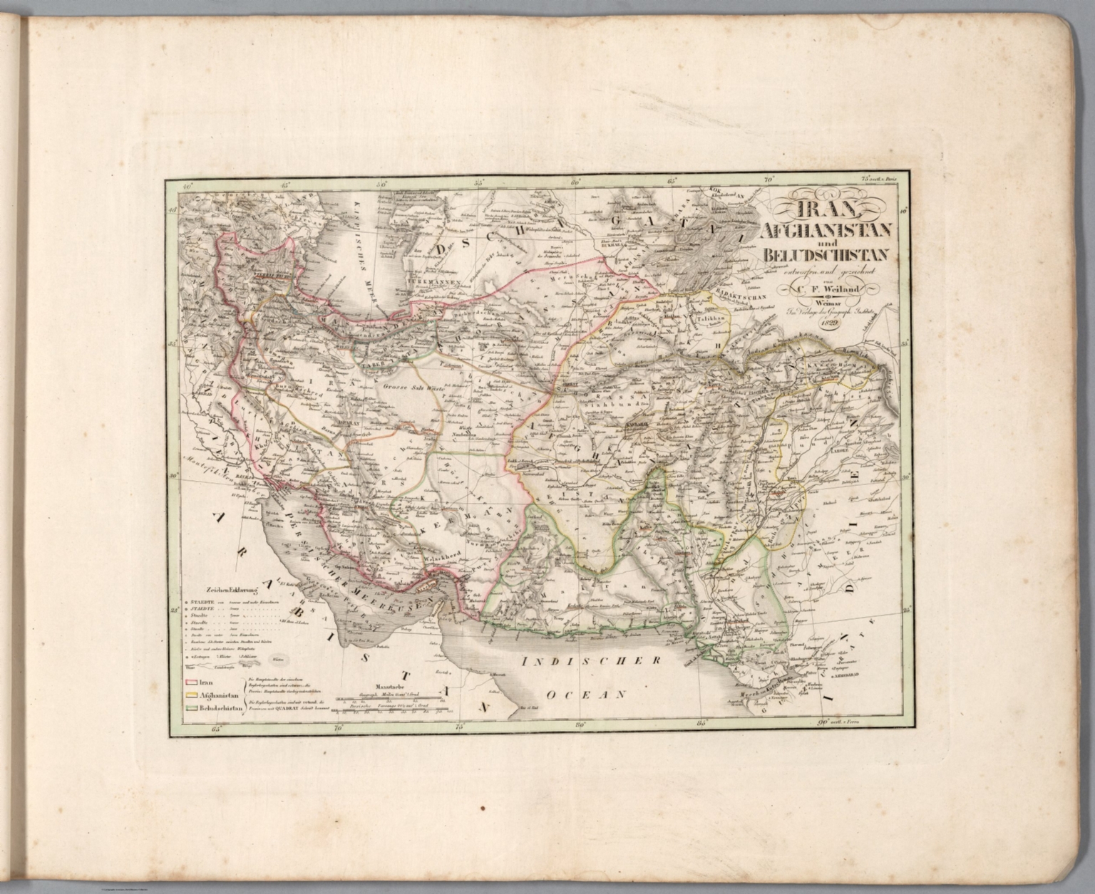
- Author
-
Weiland, C. F. (Carl Ferdinand), 1782-1847
- Subjects
- Iran, Afghanistan, Balochistan Region
- Abstract
Map of Iran, Afghanistan and the Balochistan Region, as of 1829. Shows political boundaries, cities, railways, forts, population, topography, bodies of water, drainage, coastlines and islands. Relief shown with hachures. Includes latitudinal and longitudinal lines, as well as a legend and two bar scales. Hand-colored engraving. Map is 27 x 37 cm, on sheet 45 x 57 cm. (Plate number taken from table of contents.), Hand-Atlas über alle Theile der Erde zunächst für Bürgerschulen und Zeitungsleser bestimmt by Carl Ferdinand Weiland; published in Weimar, 1829. (Date inferred based upon date of latest map within atlas.) Title translates to: General hand-atlas for all parts of the world, initially intended for public schools and newspaper readers. Bound in blue paper covers. which are blank. Collation: 2° : [2], I-XII, XIV-XIX, XXI-XXII, XX, XXIII-LX leaves of plates. This copy missing map number XIII, entitled “Preussische Monarchie”. Atlas comprised of title page and table of contents, followed by fifty-nine maps with global coverage, including two world maps (divided into Western, Eastern, Northern and Southern Hemispheres), Europe, the Middle East, Asia, Africa, North America, South America, Australia and the West Indies. Maps show political boundaries (including European colonies), cities, forts, population, railways, canals, population, topography, deserts, bodies of water, drainage, coastlines, islands and water routes. Map of North America displays territories of certain indigenous peoples. Hand-colored copper engravings with hand-drawn annotations on some maps.
- Published
- 1829
42. Persia / by Edwd. Weller, F. R. G. S. ; engraved by Edwd. Weller, Duke Str. Bloomsbury ; Day & Son Lithrs. to The Queen.
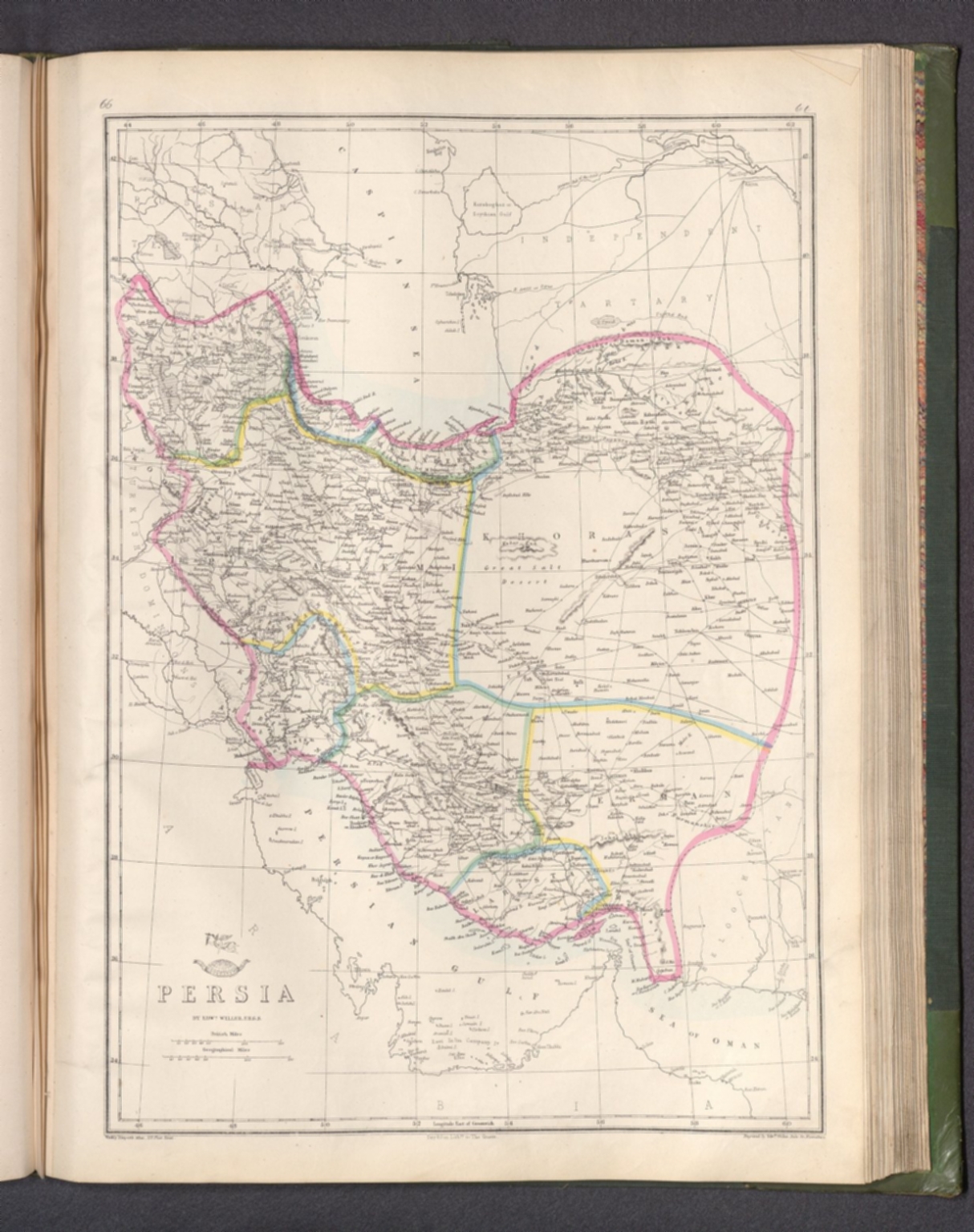
- Author
-
Weekly Dispatch, Weller, Edward, 1819-1884, and Day & Son
- Subjects
- Iran
- Abstract
Map of Persia [current-day Iran]. Shows political boundaries, cities, railways, topography, bodies of water, drainage, coastlines and islands. Relief shown with hachures. Includes latitudinal and longitudinal lines, as well as two bar scales given in British and geographical miles. Hand-colored lithograph. Map is 42 x 30 cm, on sheet 48 x 33 cm. Plate number handwritten in ink at upper right corner of sheet. Appears in Vol. II : Foreign., The dispatch atlas, in two volumes: Vol. I : British and .Vol. II : Foreign. Published by the Weekly Dispatch, London, 1863. Includes a preface, directions for binding and a table of contents for both volumes, which lists the maps in order of appearance, with plate numbers handwritten beside map titles. Preface begins: The subscribers to the Weekly Dispatch have in this collection the most full and accurate survey of the world's surface that has yet been presented to the public in any single series. Both volumes bound in board covered in dark green linen, with spine and corners in calf. Gilded spine titles, as well as ornamentation on spines and front and back covers. With marbled end papers and gilded page edges. Collation: Volume I: [6] pages, 129 leaves of plates (some double); Volume II: 147 leaves of plates (some double). The work’s total 276 plates contain 300 maps. Each plate number handwritten in ink above map. First volume focuses on the British Isles, especially England. Second volume covers the larger globe, featuring Europe, the Middle East, Asia, Africa, North America, Central America, South America, Australia, New Zealand, the Pacific Ocean and the Arctic. Maps show political boundaries, cities, fortresses, railways, roads, bridges, canals, ocean routes, topography, glaciers, bodies of water, drainage, coastlines, shoals, islands and water depths. Maps of the Americas include territories of indigenous peoples. Maps of the United States south delineate between Federal, Border and Confederate States. Some maps feature English translations of terms from other languages that describe geographic features, including the “Explanation of Arabic words" - such as nahr for river - in the Map of Syria. Maps created by Edward Weller, J. W. Lowry, B. R. Davies, John Dower and T. Ettling; printed by Edward Weller and Day & Son, Lithographers to The Queen.
- Published
- 1863
43. Persia. Tanner, Sc. (to accompany) Atlas Modern. (The Cyclopedia; or, Universal Dictionary of Arts, Sciences, and Literature. 41 vol, 6 vol. of Plates, Ancient and modern atlas.)

- Author
-
Rees, Abraham and Tanner, Henry Schenck
- Subjects
- Iran, Phila.
- Abstract
Engraved double page map. Shows boundaries and division, major cities, rivers and mountains. Relief shown by hachures. Prime meridian is Greenwich., Modern Atlas, with Melish U.S. 1820 edition. Includes separate North America and United States by Arrowsmith for the English edition. Bound in quarter leather with with paper covered boards with "Atlas. Modern." on a cover label. The atlas includes uncolored maps, with no pagination and no tile page. Map count includes 2 separate maps. 41 unnumbered maps of the modern world double page, some folded. Shows political and administrative divisions, major cities, towns, roads, railroads, canals, rivers, lakes, and mountains. Relief shown by hachures. Prime meridian is Greenwich. Includes handwritten index. For "Atlas Ancient" see Publist # 0843.000., Walsh S-09234; P711,4312a.
- Published
- 1820
44. Persia. Published by T. Brown & W. & D. Lizars, Edinburgh. (to accompany) New Edinburgh general atlas ... The maps drawn and engraved by W. & D. Lizars.

- Author
-
Lizars, William Home, 1788-1859 and Lizars, Daniel
- Subjects
- Iran, Edinburgh, Middle East
- Abstract
Hand colored engraved map. Shows political and administrative boundaries. Relief shown by hachures., Lizars' New Edinburgh general atlas of the world, contains engraved title page, with decorative borders, text and contents, 44 lithographed hand colored maps on 62 plates, some double and folded. Maps show political and administrative boundaries, cities, villages, rivers, post roads, exploration routes, rivers, lakes and mountains. Relief shown by hachures. Some maps includes notes. Prime meridian is Greenwich. The map of the United States, covers eastern and central states. Covers are brown half leather paper covered boards with title in black on front cover, the spine in seven compartments with six raised bands, gilt-lettered in one and stamped in the rest with title" New Edinrg. Atlas". Manuscript notes inside front cover and verso of title page.
- Published
- 1818
45. Nordost-Afrika und Arabien. Von A. Petermann. Bearbeitet v. Fr. Hanemann. Gest. v. E. Kuhn, Terrain v. A. Kramer. Stieler's Hand-Atlas No. 70. Gotha: Justus Perthes. 1875.

- Author
-
Stieler, Adolf, 1775–1836, Petermann, August, Hanemann, F., Kuhn, E., and Kramer, A.
- Subjects
- Egypt, Saudi Arabia, Iran, Gotha, Africa, North, Africa, East, Middle East, Africa
- Abstract
Outline color map of northeastern Africa and Arabian Peninsula. With inset map: Abessinien & Ägyptischer Sudan., 1875, 6th. edition of Stieler’s Hand atlas of the world and of the universe. Published by Justus Perthes of Gotha. It went through ten editions from 1816 to 1945. The first edition, published in 1817 by Stieler and Christian Gottlieb Reichard, with editions continuing well into the 20th century. This is the 6th. edition, with 90 maps dated 1871–75, edited by August Petermann, Hermann Berghaus and Carl Vogel. With additional set of special map of Australia on 9 sheets. This copy is a series of outline color unbound loose maps published in separate paper folders (several of which are included) over several years, placed in hard cover slip case. Some maps on multiple sheets. Maps showing political and administrative boundaries, cities, roads, railroads, canals, rivers, lakes, and mountains. Also showing European possessions and exploration routes. Relief shown by hachures and spot heights. Depths showing by soundings. Prime meridians: Greenwich, Ferro and Paris. Includes legend, text, profiles, and color coded references. All scans made at 800ppi because the loose maps could be scanned though the sheet scanner at higher resolution than the overhead camera scanner for bound atlases.
- Published
- 1875
46. Iran & Turan Oder: Persien, Afghanistan, Balutschistan, Turkestan. Von A. Petermann. Bearbeitet von H. Habenicht & F. Hanemann. Stieler's Hand-Atlas No. 62. Gotha: Justus Perthes. 1875.

- Author
-
Stieler, Adolf, 1775–1836, Petermann, August, Habenicht, H., and Hanemann, F.
- Subjects
- Iran, Pakistan, Afghanistan, Gotha, Middle East, Asian, Central
- Abstract
Outline color map of Middle East., 1875, 6th. edition of Stieler’s Hand atlas of the world and of the universe. Published by Justus Perthes of Gotha. It went through ten editions from 1816 to 1945. The first edition, published in 1817 by Stieler and Christian Gottlieb Reichard, with editions continuing well into the 20th century. This is the 6th. edition, with 90 maps dated 1871–75, edited by August Petermann, Hermann Berghaus and Carl Vogel. With additional set of special map of Australia on 9 sheets. This copy is a series of outline color unbound loose maps published in separate paper folders (several of which are included) over several years, placed in hard cover slip case. Some maps on multiple sheets. Maps showing political and administrative boundaries, cities, roads, railroads, canals, rivers, lakes, and mountains. Also showing European possessions and exploration routes. Relief shown by hachures and spot heights. Depths showing by soundings. Prime meridians: Greenwich, Ferro and Paris. Includes legend, text, profiles, and color coded references. All scans made at 800ppi because the loose maps could be scanned though the sheet scanner at higher resolution than the overhead camera scanner for bound atlases.
- Published
- 1875
47. Persia; Arabia &c. (to accompany) A New Universal Atlas Containing Maps of the various Empires, Kingdoms, States and Republics Of The World. (inset) Environs of Constantinople.

- Author
-
Mitchell, Samuel Augustus. and Knight, J.
- Subjects
- Iran, Saudi Arabia, Afghanistan, Pakistan, Philadelphia, Asia
- Abstract
Color copper lithograph map by region. Shows political and administrative divisions, capitals, important towns, mountains and rivers. Includes explanations. Prime meridian is Greenwich. Relief shown by hachures., 1848 edition, known as Mitchell's new Universal atlas, without Tanner's name on the title page. Tanner issued this atlas first in 1836 with engraved maps, then it was taken over by Carey and Hart in 1843 and converted by them to lithographic maps in 1845. In 1846 Mitchell took over the publishing of this atlas and continued until 1849. This atlas is important in American printing history in that it was the first American atlas to be converted from engraved map plates to lithographic map plates. The maps are in full color, lithographic, covering the World, North America, and Mexico. Oregon and Upper California maps show the new boundary of Mexico and the United States resulting from the Mexican War, for the first time. Title page by K. Knight, includes a view of "The first landing of Columbus in the new world". Print showing Christopher Columbus and crew praying after landing in the New World for the first time on October 12 1492. Atlas is bound in half leather green marbled paper covered boards with "Mitchell's Universal Atlas" stamped in gilt on front label. Mitchell was born in 1792 in Connecticut and spent some of his early working years as a teacher. During his teaching years, he became quite dissatisfied with the available textbooks, and this led him to become a writer and publisher. He moved to Philadelphia, a major center for publishing at the time., P6106.
- Published
- 1848
48. Perse. Gravee par U. Muschani. Imprime chez Thierry Freres, Paris. Atlas de l'Empire Ottoman, par J.J. Hellert. Planche XXIII. (to accompany) Nouvel atlas physique, politique, et historique de l'Empire Ottoman... 1844.

- Author
-
Hellert, J. J. and Muschani, U.
- Subjects
Ottoman Mapping ,Historical - Abstract
Engraved map. Shows major cities and towns. Relief shown by hachures. Prime meridian is Ferro. Includes index to provinces and neighboring countries., New political and historical atlas of the Ottoman Empire and neighboring states in Europe, Asia and Africa, in forty sheets. Drawn, reviewed and corrected by J.J. Hellert, and accompanied by a historical, geographical and statistical commentary by G. Heck, and Leon Plee. Atlas consists of engraved title page, 2 folded tables, IV, 82 pages of descriptive text and 39 engraved maps, some folded, the first double page map is colored. Includes plans of Constantinople, Dardanelles, important cities of the Empire, and the memorable sieges and battles. Atlas bound in half leather and marble paper covered boards with title "Atlas l'Empire Ottoman" in gilt on spine.
- Published
- 1844
49. Persia : Ancient and modern. London. Published by J. Wyld. 1838. (to accompany) A new general atlas of modern geography : consisting of a complete collection of maps of the four quarters of the globe ...

- Author
-
Wyld, James, 1812-1887, Wyld, James, 1790-1836, and Delarochette, Louis Stanislas d'Arcy
- Subjects
Classical - Abstract
Engraved map of Persian Empire, hand colored in outline. "Indiae Veteris Quatenus Macedonibus Nota Fuit Finitimarumque Regionum Specimen Geographicum ... Auctor L.S. DeLaRochette ". Shows administrative boundaries, major cities and towns. Relief shown by hachures. Prime meridian is Greenwich., Wyld’s general atlas in 58 pages, with engraved title and contents within decorative border printed in green. Contains 55 engraved maps, most dated 1838, hand color in outline, mostly double page and some folded, three engraved comparative charts of mountains and rivers and itinerary measures. Bound in red grained morocco, incorporating original marbled paper covered boards, original engraved title label on the front cover, and title “Wyld’s general atlas” in gilt in on spine. Atlas containing very detailed maps of the world with an emphasis on Europe, but with several important maps showing the Americas, Asia, Africa and Australia. Most of the maps have a small vignette illustrating a feature of the region. This large general atlas by Wyld is far more rare than his smaller general atlas of 1824, see our 2713.000
- Published
- 1838
50. Map of the Ottoman Dominions in Asia : with the adjacent frontiers of the Russian and Persian Empires. London. Published by Jas. Wyld. 1838. (to accompany) A new general atlas of modern geography : consisting of a complete collection of maps of the four quarters of the globe ...

- Author
-
Wyld, James, 1812-1887 and Wyld, James, 1790-1836
- Subjects
Ottoman Mapping - Abstract
Double page engraved map of Turkey in Asia, hand colored in outline. Shows political boundaries. Relief shown by hachures. Prime meridian is Greenwich., Wyld’s general atlas in 58 pages, with engraved title and contents within decorative border printed in green. Contains 55 engraved maps, most dated 1838, hand color in outline, mostly double page and some folded, three engraved comparative charts of mountains and rivers and itinerary measures. Bound in red grained morocco, incorporating original marbled paper covered boards, original engraved title label on the front cover, and title “Wyld’s general atlas” in gilt in on spine. Atlas containing very detailed maps of the world with an emphasis on Europe, but with several important maps showing the Americas, Asia, Africa and Australia. Most of the maps have a small vignette illustrating a feature of the region. This large general atlas by Wyld is far more rare than his smaller general atlas of 1824, see our 2713.000
- Published
- 1838
Discovery Service for Jio Institute Digital Library
For full access to our library's resources, please sign in.